

Introduction
Habitat is essential for human beings, and it is the basic condition for their survival and development. [1, 2] All along, scholars’ research on the issue of habitat environment has mainly focused on urban areas. However, with the progress of the times and the attention paid to the “three rural issues” in recent decades. People’s concern for environmental improvement of human habitats has also shifted from urban to rural areas. [3] Cultural and ecological reserves are essential for the preservation of human ecological welfare and are particularly important for the protection of cultural diversity. [4] Among them, the Huizhou Cultural and Ecological Reserve has a total area of 13,881 square kilometers and a total population of more than 2 million. The conservation of cultural and ecological reserves is a holistic one, from the natural ecology to the socio-ecological environment. [5] Therefore, high priority should be given to the preservation and transmission of the original conditions of existence of all the people in the protected areas. Countries around the world had been constantly exploring ways to enhance and protect the human habitat. While drawing on the protection measures of other countries, the Chinese Government has also been exploring ways that are in line with China’s national conditions.
At present, there is still room for deepening the research results on the environment of rural settlements. In terms of study areas, most of them are national [6, 7], provincial [8, 9], county [10], and wetland [11] studies. These studies have provided lessons for the improvement and management of rural habitats. However, less research has been done on the environmental aspects of village clusters in culturally protected regions. The topography of the Huizhou Cultural and Ecological Reserve is mainly characterized by undulating mountains and numerous water systems. Its ecological environment is better than that of the northern regions, but its infrastructure and public service facilities are poorer than those of the plains. Therefore, it is necessary to enhance the organization of the analysis of the evolution of the horizontal space features of the regional village settlements in a holistic view.
The rural habitat is the carrier of production and living space for rural residents. Improving rural human settlements and building beautiful and livable villages is an important task in the implementation of the rural revitalization strategy. Since the reform and opening of China, the process of industrialization and urbanization has been accelerating, with significant changes in urban-rural relations. In particular, the urban and rural territorial structure, industrial structure, employment structure and social structure have gone through a process of rapid evolution. However, the long-term urban bias, civic bias and heavy industry bias have led to the problem of decline in the countryside while China has made great achievements in economic growth and social development. The loss of rural labor force, external prosperity but internal withering, and hollowing out of rural industries and population have become huge obstacles to the sustainable development of rural habitat. In recent years, the CPC Central Committee and the State Council have attached great importance to improving the construction of rural human settlements, and the 2018 Central Committee Document No. 1 explicitly calls for the implementation of a three-year action plan for the improvement of rural human settlements. The main direction of attack is to improve the management of rural garbage and sewage and the appearance of villages. Integrate all kinds of resources, strengthen all kinds of initiatives, and steadily and orderly promote the governance of outstanding problems of the rural habitat environment. Efforts have been made to make up for the short boards that affect the quality of life of the rural masses. The report of the 19th CPC National Congress points out that the implementation of the strategy of rural revitalization, ecological livability is the key. 2021, based on the basic completion of the objectives and tasks of the three-year action program for rural habitat improvement, the five-year action of rural habitat improvement and upgrading was launched and implemented to continue to improve the rural habitat environment, and to help revitalize the countryside. The construction of rural habitat is an important embodiment of the scientific concept of development and is related to the fundamental well-being of many farmers. Strengthening the study of rural habitat is an important foothold in the construction of a beautiful, livable, and workable countryside.
In recent years, to effectively solve the various problems of environmental protection of rural human settlements. Experts have studied the issue of agricultural habitat from the perspective of combining theory and practice. In terms of empirical methods, the main approaches include multiple linear regression model [12], ordered probity regression models [13] and structural equation model [14] that rely on panel data. Since synthesizing the results of previous studies, the advantages and disadvantages of various methods were comprehensively analyzed. It was determined that the Entropy Weight TOPSIS model should be adopted for the evaluation study. The entropy-TOPSIS method is a sophisticated assessment method that adds the TOPSIS model to the entropy method. [15] Compared with the traditional TOPSIS method subjective will is lower, the objective factual data is more effectively embodied, improving the accuracy of the calculation results. At the same time, it is an attempt and breakthrough to apply the TOPSIS research method to the evaluation of human environment.
The rural Huizhou Cultural and Ecological Reserve is an integral part of the integration process of the Yangtze River Delta. The Study on the Planning of Traditional Villages in Huizhou provides a detailed study of the ecological concepts, spatial layout and habitat planning of local villages. Scholars have initially established some basic models [16, 17] and methodological steps [18] regarding rural habitat evaluation. Most of them are based on PSR (Pressure-State-Response) [19] and its extended models, which can clearly show the causal relationships in the system. However, it lacks an effective grasp of the system structure and decision-making process. Indicator weights are largely based on level organization laws and expert scoring systems, which are highly subjective [20]. At the same time, there is a lack of research on the analytical optimization aspects of the evaluation index system.
These studies show that the development of rural areas in the Huizhou Cultural and Ecological Reserve is closely related to the ecological environment. It is a key area for future implementation of environmental construction. In recent years, with the state’s support for rural construction, the condition of rural habitat has been significantly improved. On this basis, Anhui Province Huizhou Cultural Ecological Reserve is selected as the research object. The theory of “social-economic-natural” (sense) composite ecosystem is used as a guide to construct the indicators that are suitable for it. The entropy weight TOPSIS and gray correlation are analyzed for each region, to quickly understand the ecological impact mechanism of the region in recent years.
Through the collation and analysis of the relevant adaptability data of Huizhou cultural and ecological protection zone countryside, the evaluation system of rural habitat quality is constructed, the evaluation system is applied to the villages of Huizhou cultural and ecological protection zone, and the relevant problems are found according to the analysis and evaluation results and the optimization strategy is proposed, so as to achieve the purpose of improving the quality of rural habitat environment. Based on the results of the evaluation of the quality of rural habitat in the Huizhou Cultural and Ecological Reserve and the analysis of the problems, the corresponding updating strategies are proposed to improve the adaptability of the rural habitat in the Huizhou Cultural and Ecological Reserve. According to the optimization analysis and evaluation of the rural habitat environment involved in the study, it can provide certain reference for the improvement of the adaptability of the relevant protected areas.
Information and Methodology
Overview of the Study Region
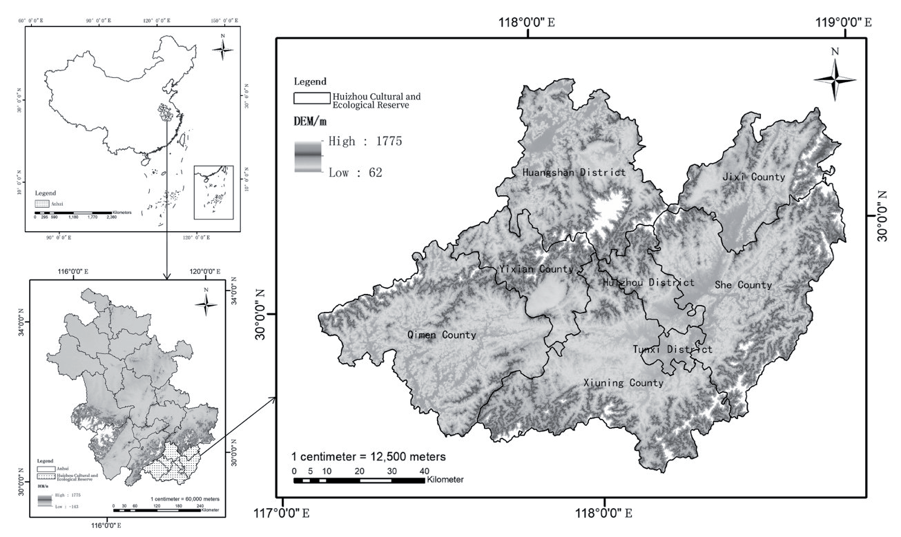
The regional scope of this study is the Huizhou Cultural Ecological Reserve (Fig. 1). The Huizhou Cultural Ecological Reserve is in the mountainous areas of southern Anhui Province and northern Jiangxi Province, covering an area of approximately 13,881 kilometers square. It is located between 117°10′E~118°55′E and 29°24′N~30°32′N, including Huangshan City and Jixi County in Anhui Province and Wuyuan County in Jiangxi Province. Due to the limitation of statistical data, this paper takes the whole territory of Huangshan City and Jixi County of Xuancheng City in Anhui Province as the specific research object, Wuyuan County in Jiangxi Province is not involved. Huangshan District, Tunxi District, Huizhou District, Yixian County, Qimen County, Xiuning County, Jixi County, and Shexian County of Huizhou Cultural and Ecological Reserve were finally selected for the study. The diversity of the region’s geography, the complexity of its ecology and the variability of its social development have led to a diversity of regional conditions. There is a clear geographical variation in the vulnerability of rural habitats in the regions.
The Huizhou Cultural and Ecological Reserve is a gathering place for humanistic and ecological values in the new era. However, in the past economic construction and development, there are problems such as irrational planning. This has caused many unfavorable effects on the economy, culture, and ecological environment of the area. The Government of China released the Triennial Operation Program for the Improvement of Village Habitat in 2014, 2018 and 2020, the Triennial Operation Program for the Improvement of Village Habitat and the Key Points for the Improvement of Village Habitat, respectively. The management of rural habitats has been pushed into an unprecedented process. This means that only by solving the ecological problems of the more backward regions. It is possible to further create a quality human environment conducive to improving the quality of life of the inhabitants of agricultural areas. Optimizing and upgrading the rural habitat environment from the actual rural areas. This is an urgent need to solve the outstanding problems of the rural environment and to safeguard people’s livelihoods.
Research Process
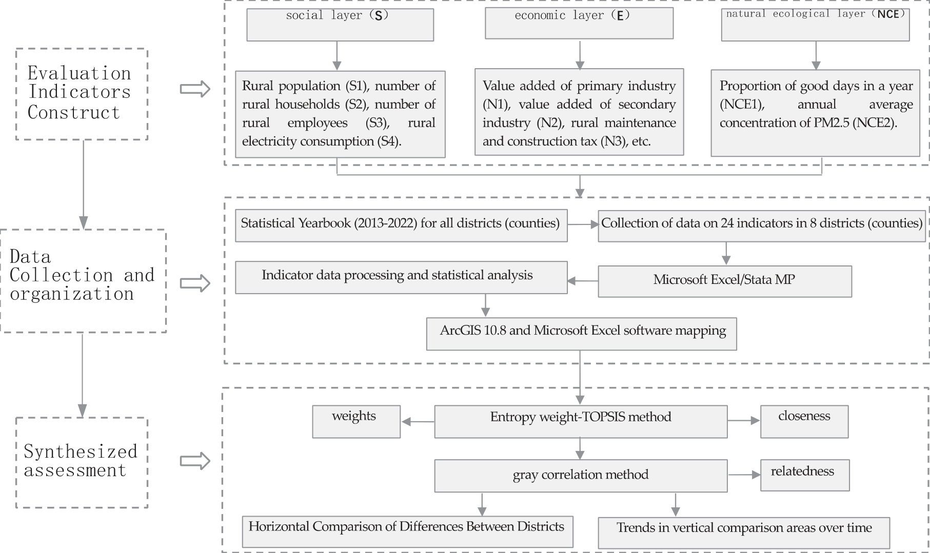
As an example, Huizhou Cultural and Ecological Reserve, 2012-2021 was selected as the study period. The specific research process (Fig. 2) is as follows: First, the construction of evaluation indicators. According to the research results of related scholars, the social, economic, and ecological environment conditions of the protected area are considered. Starting from the substantial developmental changes in Huizhou’s countryside, it combines the theory of composite ecosystem. Systematic analysis is carried out from three domains, and the indicator factors of each domain are specified in a hierarchical manner. Second, data collection and organization. The indicator data of the eight districts (counties) contain three categories: social, economic, and natural environment. Data from the District (County) Yearbook of Statistics and Bulletin of Statistics for 2013-2022. Third, comprehensive evaluation. The entropy weight-TOPSIS method was used to compare the differences in the quality of village habitat in different districts (counties) and different years. Use the gray correlation method to judge the indicators and deduce the dominant factors influencing the village habitat quality.
As a specific space for human settlement, cultural ecological reserves are undoubtedly an important research object in habitat science. As cultural ecological reserves contain rich cultural and ecological values, people need to protect their natural and cultural environments to ensure their sustainable development. This study is anticipated to advise on rural settlement levels and ecological policy development in similar protected areas. To achieve ecologically, socially, and economically sustainable development of settlements in a coherent manner.
Indicator Construction
The human habitat can be regarded as the surface space that is closely linked to human settlement, production, and life; it is the basis for human survival and the main place for human beings to utilize and transform nature. Rural habitat, as an important part of the human environment system, is the environment created by rural residents during their production and life, such as housing, transportation, farming, culture and recreation, education and health, and the utilization and modification of nature. This study divides the rural habitat into two parts: the hard environment of rural habitat and the soft environment of rural habitat. The hard environment of rural habitat refers to the material environment of rural habitat, which is the sum of all material facilities serving and utilized by rural residents as the carriers of farmers’ production and life, and it is the unity of spatial, humanistic, and natural elements, consisting of both space and entity, mainly including rural natural ecology. The soft environment of rural habitat refers to the sum of all non-material things that farmers can personally feel in the process of production and life, which is a kind of intangible environment, mainly including rural economic development and social services. Therefore, this paper selects rural natural ecology (NCE) to measure the quality of the hard environment of rural human settlements, and rural economic (E) development and social (S) services to measure the quality of the soft environment of rural human settlements.
Fig. 2.
Framework for Research on the Environmental Performance of Village Habitat in Huizhou Cultural and Ecological Reserves.
The SENCE conceptual framework is an ecological functional unity that is a combination of human social and economic activities and natural conditions [21, 22]. That is, the SENCE composite ecosystem (Fig. 3). Since the human habitat is a complex system, it encompasses a wide range of factors, including the economy, education, standard of living, social conditions, and the environment. It is hard to use a single criterion to evaluate multiple aspects of an abstract system. Rural settlement systems are characterized by openness, non-linearity, instability, and continuous fluctuation. At present, there are large differences in the rural zoning of the Huizhou Cultural and Ecological Reserve. There is a mismatch between the human environment and infrastructure development. Therefore, the SENCE conceptual framework was adopted in this study to adequately reflect the status and trends of protected areas. Moreover, the dynamic relationship between the levels is clearly shown.
The SENCE conceptual framework can both objectively reflect the current situation and problems of rural habitat environment and meet the requirements of scientific and systematic [23, 24]. The framework is a new approach to the study of the human habitat environment, which has a positive and realistic guiding significance. The results of the study on environmental assessment and indexing systems for rural habitats identified three subsystems: social (S), economic (E) and natural ecology (NCE). Referring to the results of previous research and combining the interpretation of the concept of rural habitat in this paper. The construction of the indicator system focuses on the strategy of rural revitalization. It reflects the developmental changes in agriculture, rural areas and farmers’ lives and the scientific content of environmental construction. The connotations of the indicators should avoid duplication and overlap and be able to evaluate and compare the effects of construction. At the same time, data sources should be stable and reliable, and easy to collect, process and use. Drawing on relevant research results, 3 guideline layers and 24 indicator layers were comprehensively and quantitatively evaluated to establish a rural habitat quality evaluation system (Table 1).
At the same time in the selection of indicators, this paper combines the geographical characteristics of Huizhou Cultural and Ecological Reserve, based on the selection of principles of human environment science, specifically including the following principles. First, the principle of targeting, closely around the attributes and characteristics of each level of indicators, targeted selection of related indicators to objectively reflect the evaluation of the reality of the development characteristics of the object. Second, the principle of systematicity, the first, second and third level indicators are clearly hierarchical and interconnected, and the indicators have a certain logical relationship with each other and can constitute an overall system. Operability principle, the data source of each indicator comes from the actual sampling, to ensure the consistency of the statistical unit and caliber of each indicator.
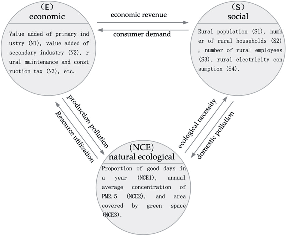
Table 1.
Comprehensive quantitative assessment indicator mechanism for the quality of village habitat.
Through the above analysis methods, the hierarchical structure of the urban and rural habitat quality evaluation index system of Huizhou Cultural and Ecological Protection Zone is finally determined as 1 target layer, 3 guideline layers and 24 indicator layers. The target layer, i.e., the general objective of this hierarchical model, is the quality of urban and rural habitat environment in A Huizhou Cultural and Ecological Reserve. The guideline layer (first-level indicators) is the subdivision and specification of the system layer of this hierarchical model. They are social (S), economic (E) and natural ecology (NCE) 3 types of indicator elements. Indicator layer (second-level indicators) based on the construction of the first-level indicators, the expansion of its indicators, the expansion of the indicators is the materialization of the subsystem layer. The subsystem layer is expanded through generalization and screening, with a total of 24 secondary evaluation indicators. The specific selection is based on the following:
First, the social layer (S) [25]. “Society” corresponds to the social subsystem in the evaluation indicator system. It refers to the interrelationships and social systems formed by human interactions. It includes social relations, cultural characteristics, public administration, economic development, etc. Eight indicator layers were chosen to measure: the number of rural population (S1), the number of rural households (S2), the number of rural employees (S3), rural electricity consumption (S4), the number of villages with broadband access (S5), rural employment subsidies (S6), pesticide use (S7), and the number of cars owned by rural residents per 100 households (S8).
Second, the economic layer (E) [26]. The economic subsystem encompasses the full range of productive and commercial activities on which mankind bases its livelihood and growth. The level of economic production is one of the driving factors in the growth of village habitation and affects the standard of living and production in villages. It considers the strategic requirements of the Strategic Plan for Rural Revitalization (2008-2012) in terms of enriching cultural life in the countryside and increasing the supply of public services in the countryside. Meanwhile, considering the basic situation of farmers’ production and life, eight indicator layers were selected for measurement. The main indicators are rural maintenance and construction tax (E3), the total composition of the agricultural industry (E5), rural minimum living expenses (E6) and Engel’s coefficient of rural households (E8).
Third, the natural ecological layer (NCE) [27]. The natural ecosystem subsystem is the foundation of the composite ecosystem, which simultaneously specifies the scale and characteristics of the composite ecosystem. Natural ecology is the key to efficient village development and the foundation of rural ecological civilization. In conjunction with the Strategic Plan for Rural Revitalization (2018-2022), the strategic requirements for building ecologically livable and beautiful villages and safeguarding and improving people’s livelihoods include promoting clean agricultural production, focusing on solving outstanding problems in the agricultural environment, accelerating the remediation of outstanding shortcomings, focusing on upgrading the appearance of villages, improving the conditions of rural transportation and logistics facilities, and consolidating the foundation of rural informatization. At the same time, taking into account the actual production and living conditions of farmers, the percentage of sunny days in a year (NCE1), the annual average concentration of PM2.5 (NCE2), and the area covered by green space (NCE3) are selected as ecological environment quality indicators. “Nature” refers to the natural environment and ecological resources of human settlements, including topography, water, and land, etc., and is the key to sustainable rural development in the future. Per capita daily domestic water consumption (NCE4), sewage discharge (NCE5), centralized sewage treatment rate (NCE6), area of landscaped greenspace (NCE7), and green space and plaza land (NCE8) were chosen to be measured.
Sources of Data for Indicators
Considering the availability of data, statistical data from eight districts (counties) in the Huizhou Cultural and Ecological Reserve were selected for this study. Administrative division data for the study area was obtained from the National Geographic Information Database (NGID). Data on social and economic aspects come from the district (county) statistical yearbooks and statistical bulletins from 2012 to 2022. Most of the indicator data were accessed through the above databases. Linear interpolation was added for some districts with absent figures. From them, the data needed for this study were screened and organized, and a comprehensive assessment was performed by the entropy weight-TOPSIS method and GRA method. The survey data processing and statistical analysis in the study were completed using Microsoft Excel and Stata MP software, and mapping was done using ArcGIS 10.8 and Microsoft Excel.
Evaluation Methodology
The entropy weight TOPSIS method is used, which can be used to calculate the weight of each indicator, and then the TOPSIS method is used to calculate the indicators of rural habitat. The weights are determined objectively using the information provided by each indicator. The entropy method can objectively reflect the importance of each indicator in the evaluation system. It is therefore suitable for objective evaluation of the environmental quality of human habitats. [28] TOPSIS focuses on defining the separation between the best and worst resolution of the decision problem. Finally, the relative approximation of each evaluation objective to the desired resolution is compute. From there, the advantages and disadvantages of the solutions are ranked. [29, 30] Combining the two methods, the calculation results are more objective and accurate [31]. It has been effectively applied to assess the living ambient conditions in villages. Using the methodology described above, an index of rural habitats in the Huizhou Cultural and Ecological Reserve was generated from the data obtained from the data processing.
Gray correlation analysis determines the extent to which the target to be recognized affects the target of the research by comparing the strength of each association. [32, 33] This approach allows quantitative methods to measure the evolution and changing dynamic of the system and is ideally adapted to kinetic-historical characterization. The correlation coefficient as well as the correlation formula were used to calculate the gray correlation of various indexes with the quality of village habitats, respectively. The group used the gray correlation method to analyze the factors affecting the quality of village habitats in the Huizhou Cultural and Ecological Reserve. This has a certain degree of accuracy and scientific validity. The two methods mentioned above have different principles and bases for decision-making and are highly complementary. In the present study, a comprehensive evaluation model for the quality of village living environment was established by integrating entropy weight TOPSIS and gray correlation analysis. The calculation steps are as follows:
First, entropy weight TOPSIS comprehensive evaluation method. Suppose there are y programs to be evaluated and x indicators. A statistical indicator data matrix M = (Nij)y×x can be formed. When one of the indicators is positive, the value Mij is normalized by the formula:
Where, when the index is a reverse index, the normalization formula for the Mij value is:
Where Mij is the original data. The entrepreneurial weights of each index are calculated using the normalized data matrix with the formula (3):
Where Zij is the weight of the i th evaluation program in the j th indicator,
From the weight matrix and step (1), we get the normalization matrix formula M = (Nij)m×n, which leads to the indicator weighting matrix formula:
Where qij – NijWj.
Calculate the composite score of each indicator. The optimal and worst solutions for each indicator can be calculated through the weighting matrix of the indicators, Equations (5) and (6) are:
The Euclidean distance formula was used to compute the following values for the separation between the optimal and minimum options as well as the composite scores. The formula for the district among the optimal and the poorest scenarios is given as:
For each measurement scenario, calculate the relative proximity to the desired scenario. From Equation (9), 0<F<1. When F = 1, the optimal solution is reached. Conversely, the worst solution is reached when F = 0. The closer F is to 1, the closer the regional indicator is to the optimal solution and the highest score is achieved. The comprehensive score formula is:
Second, gray correlation analysis. Find
Where δ = 0.5, Sij+ are the gray correlations between region i and the positive ideal solution indicator with respect to the participant indicator j.
Sij– is the extent to which region i is linked to the negative ideal solution indicator relative to participant indicator j.
Comparison between Different Regions
The composite index of Huizhou Cultural and Ecological Reserve gradually recovered from 2021 (0.483) to 2012 (0.498) (Table 2). The evaluated values of the composite from 2012 to 2021 were 0.498, 0.58, 0.273, 0.288, 0.312, 0.398, 0.38, 0.423, 0.445, and 0.483, respectively (Fig. 4). Huizhou Cultural and Ecological Reserve has implemented natural ecological protection projects, architectural Huizhou style renovation projects and folklore protection projects in the process of creating the reserve. Indiscriminate logging is prohibited in the conservation zone to protect the good natural environment. Overall, the condition of the regional countryside habitat shows a trend from decline to recovery. Specifically, it can be categorized into the following three stages.
Table 2.
Relative proximity, 2012-2021.
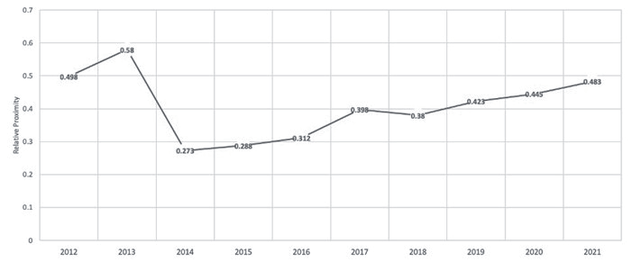
First, the basically flat stage in 2012-2013. 2012-2013 Huizhou Cultural and Ecological Reserve Rural Habitat Harmonization Index showed a small upward trend. The reason for this is that the foundations of the rural environment in the region are relatively underdeveloped. In 2012-2013, the synchronization of rural output, livelihoods and the quality of ecology were improved. At the same time, local governments are emphasizing the reduction of geographical disparities in the rural habitat quality. Huizhou Cultural and Ecological Reserve relies on advantageous resources such as natural landscape, rural scenery, and ethnic customs. Vigorously developing rural tourism has effectively driven the development of the agricultural industry in rural areas. During this period, the strengths of high-level districts (counties) are maximized, and various types of factors are promoted for cross-regional exchange and mobility. The result is a natural ecological protection, architectural style creation and folk culture atmosphere. This is not only conducive to the rapid restoration of Huizhou’s cultural ecology. It also provides a favorable environment and conditions for the protection of cultural forms, including intangible cultural heritage.
Secondly, there is a phase of significant decline in 2013-2014. Over this period, the Habitat Score has shown a decreasing trend. Although the level of production and living environment continues to rise. However, the ecological environment has been damaged to a degree that makes it hard to improve it in tandem with production and living conditions. The philosophy of ecological primacy should be always maintained. Various protected areas are also actively exploring ways to harmonize cultural and ecological conservation with socio-economic development. For example, the preservation of Rhegong art is linked to the cultural industry, the tourism economy and the poverty alleviation and enrichment of local villagers. Make it a driving force for local socio-economic development. Therefore, the local government and villagers have also shown considerable enthusiasm for the construction of the protected area.
Third, a phase of modest climb from 2014-2021.The Harmonization Index has increased from 2014-2021, but the increase is small. It shows that the construction of rural habitat in the Huizhou Cultural and Ecological Protection Zone has achieved positive results and significantly improved in quality. The reason for this is, on the one hand, that governments at all levels are actively promoting the implementation of measures such as “beautiful villages” and “rural habitat improvement”. In contrast, driven by rapid urbanization and industrialization and rapid socio-economic development, the production, life, and ecology of rural areas have been significantly upgraded. However, the quality of the natural environment in the Huizhou Cultural and Ecological Reserve is also affected by the increased intensity of human activities in some counties. As a result, ecological sensitivity has become an important constraint on changing the quality of habitat.
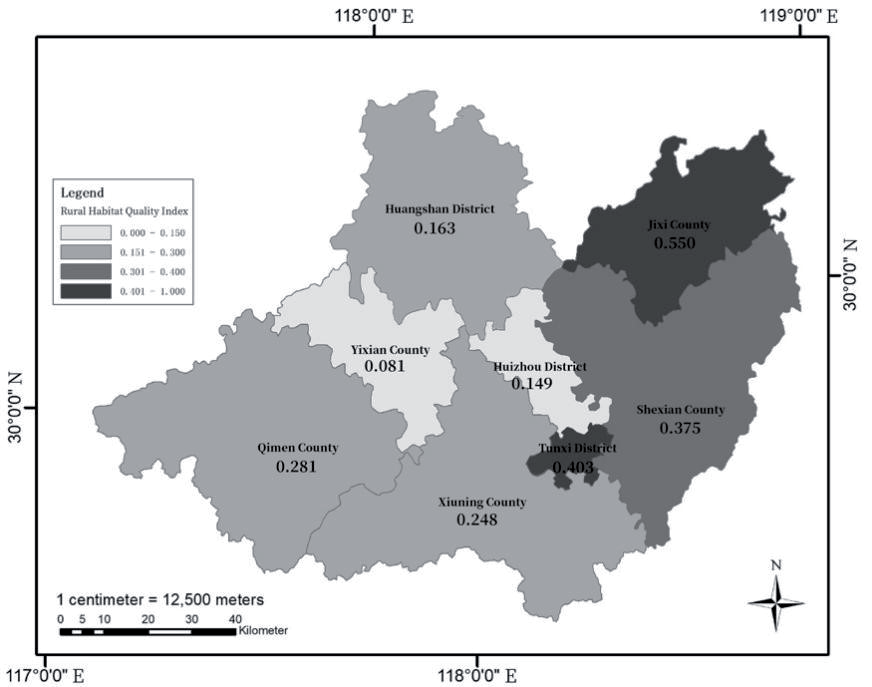
Comparison of relative proximity values of different regions based on entropy-weighted-TOPSIS method (Fig. 5). The composite index of the districts (counties) in the Huizhou Cultural and Ecological Reserve, in descending order, are Jixi County (0.550), Tunxi District (0.403), Shexian County (0.375), Qimen County (0.281), Xuning County (0.248), Huangshan District (0.163), Huizhou District (0.149), and Yixian County (0.081). Jixi County (0.550) is in the first place in the overall evaluation. Meanwhile, Jixi County is also always in the first place in the year-to-year change from 2012 to 2021. Relevant financial, transportation and environmental protection policies in Jixi County have been more supportive of rural habitable construction. This has enhanced the development of rural industries, culture and education, health care, road transportation and environmental protection facilities.
The results of the study show that the average score for the quality of village settlements in the Huizhou Cultural and Ecological Reserve is 0.281. The overall level of the quality of village settlements in the Huizhou Cultural and Ecological Reserve is low. Among them, Yixian County (0.081) ranked in the bottom one in terms of the composite index. Changes in the indicators over the study period show that the number of people working in the villages (S3) has been declining year by year. The loss of labor force has led to the effects of idle land, low efficiency, and outdated facilities, which have greatly limited the development of villages. This shows that residents have a weak awareness of water conservation, and the task of rural sewage treatment is arduous. The counties and districts are at different stages of development in terms of natural environment, industrial conditions, culture, and education. There are also major differences in the effectiveness of the implementation of the relevant policies.
Comparison between Years
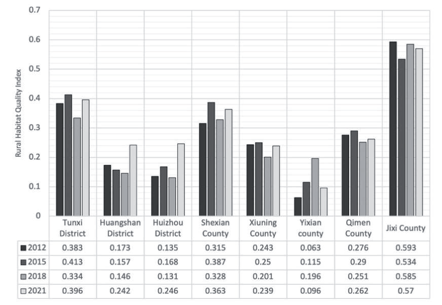
Combined with the entropy weight-TOPSIS results, the relative proximity of each region of the Huizhou Cultural and Ecological Reserve was calculated for 2012, 2015, 2018 and 2021 (Fig. 6). Most of the districts (counties) maintain a stable state, with Jixi County having the best human environment condition. Among them, Tunxi District (0.383-0.396), Huangshan District (0.173-0.242), Huizhou District (0.135-0.246), Shexian County (0.315-0.363) and Yixian County (0.063-0.096) showed an upward trend in the state of habitat. Habitat status in Xiuning County (0.243-0.239) and Qimen County (0.276-0.262) showed a decreasing trend.
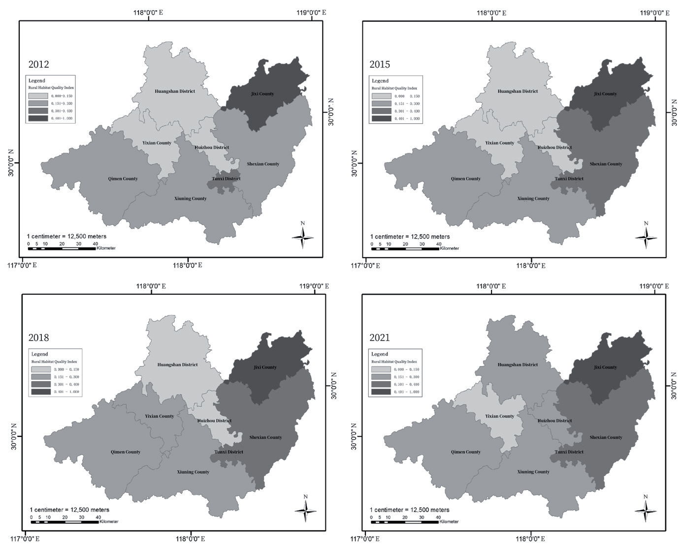
Based on the results of entropy weight-TOPSIS, the suitability of rural habitat environment in Huizhou Cultural and Ecological Reserve was quantitatively analyzed. Using ArcGIS 10.8 program, the relative proximity index was classified into four levels. And the trend of relative proximity index for each district in 2012, 2015, 2018 and 2021 was plotted (Fig. 7). Over the research timeframe, all districts (counties) showed an upward trend in the level of sustainable level of rural human settlements. However, there are some differences between districts (counties). The main manifestation is that the quality level is higher in the southeastern part of the country, while the northern part is lagging. Along with the improvement of the level of environmental sustainability, the differences between the districts (counties) are gradually decreasing.
In 2012-2015, the average standard of living in the Huizhou Cultural and Ecological Reserve was not high, and the living conditions in most areas still need to be improved. In all districts (counties), the environmental condition indices are greater in the south than in the north, and greater in the east than in the west. Being an ethnic region with an ancient heritage, the area has always been influenced by multiculturalism, reflecting a diversity of living habits. Among them, the rural habitat in Shexian County is in a state of benign development. This indicates that local management interventions have been strengthened to enhance ecological protection. To create a model and provide experience for building a beautiful and livable rural habitat.
In 2015-2018, the differences in the Huizhou Cultural and Ecological Reserve were significantly reduced. The Government formulated rural development strategies in the context of regional realities. As an example, the villages which include Jixi County, Tunxi District and Shexian County will be a precious asset to the high-level industrialized regions. These areas are subject to little interference from human activities, are rich in vegetation types and have a relatively stable ecological spatial pattern. An important ecological barrier has been constructed for the surrounding areas. In the future, the countryside will become an area for residents of cities to feel nature and experience inherited traditional culture. It is therefore suggested that rural areas should explore the characteristics of regional assets, promote traditional culture, and realize sustainable rural development.
From the time pattern of 2018-2021, the score coefficients of the districts (counties) of the Huizhou Cultural and Ecological Reserve gradually decrease, and the gap gradually narrows. The districts (counties) show a trend of change from small to large growth rates. In terms of spatial patterns, the eastern region consistently achieves high-quality rural human settlements, with the higher-ranking Jixi County, Tunxi District and Shexian County all located in the east. This indicates that local policy concepts have to some extent been implemented. These three districts (counties), while focusing on economic development, have focused on the protection and improvement of the biological conditions of the rural habitat. This has achieved a situation of double excellence in economy and ecology. Government departments should pay attention to weak counties, explore the potential of rural industries, shape special industries and build core competitiveness. In the improvement of rural ecological environment, it is necessary to find out the foundation of the current situation of rural ecological environment. The districts (counties) have a better foundation, showing a certain trend of improvement. This ensures the existing level of ecological settlement and decreases the adverse effects on rural production and life. To ensure a good rural living environment, and to realize the concept of “green mountains are golden mountains”.
Level of Impact of Different Indicators
GRA makes decisions based on the similarity of the geometrical patterns between evaluation units and positive and negative “ideal solutions”. In this study, the gray correlation method was adopted to rank the relevance of 24 indicators in the evaluation index system (Table 3). This results in the extent to which all the metrics impact on the village human condition quality. The findings of the study showed that the gray correlation factor for most of the indicators exceeded 0.80. This indicates that the indicators selected in this study can synergize with each other on the quality of rural habitat. The correlation coefficients of the top eight indicators are above 0.900. In descending order, the percentage of good days in a year (0.977)>number of households in the countryside (0.974)>area of green space in gardens (0.974)>number of villages with broadband access (0.973)>centralized sewage treatment rate (0.971)>number of people in the countryside (0.971) >number of people in the countryside (0.963)>area covered by green space (0.961).
Based on the results of the gray correlation, Governments are expected to focus on addressing the major barriers. Habitat mass can be viewed as a huge, complicated, and dynamic system. Elements affecting habitat quality encompass the natural setting, social progress, and economic development. The top eight indicators are from the social layer (S) and the natural ecological layer (NCE). Among them, proportion of good days in a year (NCE1) has the greatest influence. This suggests that the suitability of the living environment in villages is largely influenced by weather quality. Currently, the major influences on the rural living conditions are temperature, temperature difference and precipitation. Suitable temperature is one of the necessary conditions for human habitation. Currently, most rural residential spaces are built with a temperature reference point of 26 degrees Celsius, which is also the ideal temperature environment. At the same time, proper air humidity is crucial, and it directly affects the feeling of living. Dull, humid, and other residential spaces not only affect the life of the building, but at the same time seriously impair the quality of living.
Although the physical surroundings cannot be altered easily, livelihood requirements, communal facilities and infrastructures are the main obstacles to the quality of village dwellings. Therefore, there is a need to develop a holistic concept that addresses the various barriers to the value of human habitat. The area of this study is in Anhui Province. Anhui Province adheres to the principle of “adapting to local conditions and classifying and guiding”. It is comprehensively promoting rural living garbage treatment, sanitary toilet renovation, sewage treatment and other habitat projects. Full coverage of the rural household waste treatment system has finally been realized. The appearance of villages has been significantly improved, and a long-term management and care system has been initially established. In 2018, the penetration rate of rural hygienic latrines in Anhui Province will reach 68%, and the penetration rate of centralized water supply will reach 67%.
Table 3.
Degree of relevance of indicators for evaluating the quality of rural habitat.
Discussion
Many of the existing research papers and works on Huizhou Cultural and Ecological Reserve are about its village cultural heritage, protection, and development, mainly exploring its history, culture, landscape, pattern, etc., but seldom researching from the perspective of human habitat environment. This study systematically analyzes and evaluates Huizhou Cultural and Ecological Reserve from the perspective of village habitat environment, which can enrich the content of related research. In this study, the evaluation of rural habitat environment in Huizhou Cultural and Ecological Reserve is studied, the evaluation system is constructed, and the entropy weight TOPSIS method and gray correlation method are comprehensively utilized to select eight districts (counties) in Huizhou Cultural and Ecological Reserve and evaluate their habitat environment.
First, the results of the comprehensive evaluation show that there is a large gap between the first-ranked region and the last-ranked region. The difference in the composite index between Jixi County (0.550) and Yixian County (0.081) is 0.469. Governments should explore locally appropriate economic growth models and enhance the infrastructure of human habitation in the light of unique local resource endowments. Wang, X et al. showed that investment in public facilities is the main factor driving rural green development [34]. The preparation of a comprehensive, scientific, and rational regional plan for the construction of village habitat is beneficial to giving full play to the cohesive function of regional integration.
Second, the study showed that the average habitat quality score for villages in the Huizhou Cultural and Ecological Reserve was 0.281. This suggests that the growing intensity of environmental transformation intensifies the impacts on physical systems, resulting in critical challenges to indigenous sustainable development. While improving the production and living environment, it is necessary to utilize land as intensively as possible and avoid large-scale encroachment. As an example, the hardening of roads and the spread of built-up land provide facilities for human beings while at the same time destroying the existing natural scenery. This causes ecological decline and a lowering of the worth of ecosystem values. Furthermore, the policy and industrial planning should be used to break the imbalance and realize the overall enhancement of the Huizhou Cultural and Ecological Reserve.
Third, all 24 factors selected for this study have some influence over the quality of village habitat, but the extent of their influence varies widely. First, the natural ecological layer (NCE) has the greatest influence, which shows that a good ecological environment is the main factor influencing the enhancement of rural habitat. The findings of scholars such as Wang, N showed that strengthening ecological management, reducing habitat alteration, and restoring degraded natural habitats are essential for maintaining biodiversity [35]. Wu, C et al. similarly showed that strengthening ecological control while maintaining sustained and stable economic development [36]. Among them, the proportion of good days in a year (0.977)>the area of landscaped green space (0.974)>the centralized sewage treatment rate (0.971)>the area covered by green space (0.961). Secondly, the major influence on habitat quality is social class (S). From the evaluation results, the number of rural households (0.974)>the number of villages with broadband (0.973)>the number of rural population (0.971)>the number of rural employees (0.963).
According to the analysis of the characteristics of the village environment of Huizhou Cultural and Ecological Reserve and the adaptive evaluation and result analysis. Give the corresponding adaptive updating and upgrading strategies from the village as a whole to the three dimensions of society (S), economy (E) and natural ecology (NCE). It provides a certain reference for the protection and adaptive development of villages in Huizhou Cultural and Ecological Reserve.
This study preliminarily reveals the spatio-temporal landscape characteristics of village settlements in Huizhou Cultural and Ecological Reserve. It also explores the factors and laws affecting the spatial differences. It is necessary to further deepen the study of the evolution of long time-series spatial patterns and their formation mechanisms in the future. However, due to limitations in data collection at the district (sub-district) level. Natural disasters, toilet revolution, rural health, rural education and policy considerations are not included in the indicator framework for the time being. In the context of the implementation of the rural revitalization policy and the five-year action to upgrade the village environment. It is recommended that the relevant indicators be incorporated into China’s rural statistical indicator system. This will provide basic data support for improved vulnerability assessment of village dwellings and strengthened monitoring of the state of village revitalization.
Conclusions
The research area focuses on areas where there has been little habitat science research. This study shifted from traditional urban areas to cultural and ecological reserves. Future studies should do in-depth research on the types of rural habitat. Combined with the current situation of rural habitat development in different regions, active and effective measures should be taken to improve the level of rural habitat, tailored to local conditions, guided by zoning, and focused on promoting the integrated development of urban and rural areas and the optimization and adjustment of industrial structure. Give full play to the advantages of the countryside in terms of natural environment and folk culture, create an industrial system of leisure agriculture and rural tourism, and spread the cultural value of the countryside. Promote the integration of urban and rural infrastructure and the equalization of public services, to achieve the continuous improvement of the rural habitat.
The research angle is refined from daily areas to special areas. The refined research areas can be used to a certain extent as the basis for environmental research on cultural and ecological reserves. This will improve the territorial spatial layout planning, integrate, and optimize the spatial control of cultural and biological reserve planning. And combine traditional cultural activities with ecological protection. The formation of ideal habitat space is the “optimal development path” for the harmonious coexistence of human beings and nature in the construction of ecological civilization. The following suggestions are put forward with a view to providing some references for promoting the optimization of the habitat environment of villages in the Huizhou Cultural and Ecological Reserve.
First, local advantages should be tapped, and regional differences should be narrowed. To optimize the strengths of high-level districts (counties) and to facilitate inter-county exchanges and mobility in the form of complementary strengths. For areas undergoing significant evolution, local governments should enhance the development dynamics of villages and adjust to impacts and risks in the outside environment. For areas that are lagging in economic development, the supply of libraries, cultural centers and cultural stations should be constantly increased to promote the regional culture of Huizhou. In addition, set up display programs such as demonstration gardens or museums of intangible cultural heritage. Intangible cultural heritage products such as Huizhou three carvings, Wanan compass, and Huizhou ink production techniques will be centrally displayed. This will not only increase the variety of tourism viewing and even experience, but also allow the inheritors to earn economic income in it. This will enhance the enthusiasm of the heritage and promote the cultivation and growth of the heritage team.
Secondly, we should accelerate the upgrading of the quality of the housing system and improve the happiness index of villagers. To do a good job of planning for village and town systems and planning for rural housing construction and the renovation of dilapidated buildings. Combine planning for urban villages and villages on the fringes of cities with the renovation of old towns and the construction of new districts. An increase in farmers’ income is the key to a prosperous rural life. First, we are vigorously promoting the development of agrotourism, research and study, and recreation and health care, and constantly broadening the channels for increasing incomes. Secondly, financial, monetary, and human resources support and skills training should be increased. It promotes local and nearby employment for the rural population and facilitates sustained increases in farmers’ incomes and disposable incomes. In addition, it also guides reasonable consumption in villages and promotes the upgrading of village appearance. Habitat conditions are further optimized.
Thirdly, public service support should be strengthened to continuously improve the quality of the social system. First, there is a need for government departments to increase their financial and human investment in environmental protection and governance. A nationwide action to improve the environment without garbage is being carried out. Raise awareness of environmental protection among all people, guide villagers to establish scientific concepts, and advocate a healthy and environmentally friendly lifestyle. Secondly, in terms of agricultural production, technological innovation should be strengthened to improve the utilization rate of agricultural inputs and reduce the production of waste at source. Lastly, quality medical resources have been promoted to cover county-level general hospitals, township central health centers and village health clinics. The level of medical services in villages has been further upgraded.

