

Introduction
The hydropower development volume of Jinsha River, Yalong River, Dadu River and Minjiang River accounts for 90% of Sichuan province. Among them, the Dadu River Basin belongs to the southwest mountain area of China’s five major ecologically fragile areas. The terrain is undulating, the geological environment conditions are complex, and geological disasters are frequent occurrences. It is a sensitive area for climate and biological response. Lai 2020 took the lower reaches of the Dadu River as the research area [1]. Based on the multidisciplinary theoretical knowledge and methods of geology, geography, ecology, etc. Combined with GIS, the ecological environment vulnerability evaluation model of the research area was established to explore the main geological factors affecting the ecological environment vulnerability of the research area. The research shows that the influence degree of geological factors on the ecological environment vulnerability of the research area is ranked as follows: rock type > rock hardness degree > fault density > separation > strike of faults. Yao 2020 took the Dadu River as the research area, and used five methods to evaluate the sensitivity of geological disasters in the Dadu River Basin, using the logistic regression model, the information quantity model, a combination of the information quantity model and the logistic regression model, spatial logistic regression, and a combination of information quantity and the spatial logistic regression model [2]. It is revealed that the ‘’high’’ and ‘’extremely high’’ prone areas of geological disasters are mainly distributed along both sides of the Dadu River. The road crowning distance factors and river distance factors have a great contribution to the evaluation process. Wang et al. 2023 took Kangding City as the research area [3]. Meanwhile, the researchers used the evidence weight model and the reduction coefficient method to divide the landslide hazard susceptibility based on the slope unit. The results showed that the ‘’extremely high’’ and ‘’high’’ susceptibility areas were mainly distributed along the Kangding River, the Yala River near the Lucheng Town and Erdaoqiao Village in Kangding City. In addition, scholars such as Ding 2007, Ba 2011 and Xu 2013 also studied the development characteristics and distribution of geological disasters in the deep - cut gorge area of the Dadu River Basin [4-6].
For long-distance power transmission projects in areas with complex geological environments, the lines need to cross many geomorphological and geological units. The geotechnical types along the lines are complicated. Therefore, the project construction and operation processes are easily threatened by numerous kinds of geologic disasters [7-15]. In this paper, the influence of site selection of transmission tower foundation and the risk assessment of geological disasters in transmission lines are studied. Some scholars have performed a series of work on geological disasters and their control measures in the investigation of transmission line engineering in mountainous areas, and regional geological disasters induced by earthquakes [16-25]. In western Sichuan, what is the impact of frequent geological disasters on the selection of sites for transmission projects, transmission line planning, and design? How to choose better engineering sites under the complex geological environment in western Sichuan? In this paper, we take the Erlang Mountain Deep - Cut Gorge Area of Dadu River as the research object. Then, based on the remote sensing interpretation and the geological disaster investigation in the area, some scholars research the development characteristics of the collapse disaster and the impact on the transmission project. The results of the study can provide a theoretical basis for the evaluation and prevention of geological disasters along the transmission corridor. In addition, the results provide technical guidance for selecting of lines, designing and constructing the power transmission projects.
Methods
Geological Setting of the Study Area
The Deep - Cut Gorge Area of Dadu River is located in Ganzi Tibetan Autonomous Prefecture and Ya’an City, Sichuan Province. It involves Kangding, Luding County, Tianjin County, Xingjing County and Hanyuan County, with the highest altitude in the area being the Yanzigou Gongga Mountain in Luding County, with the highest peak reaching 5751 m. There are three rivers in the area, including the Deep Cut Canyon Area of Dadu River, Kangding River and Yalah River. These rivers present deep - cut gorge geomorphology along both sides of the river valley, with the slope angle exceeding 40°. The transmission line in the area starts from Zheduo Mountain in the west to Erlang Mountain in the east, which is roughly laid along the river valley.
The stratum lithology of the study area is very complex. The formation age of strata is from archaeozoic era to mesozoic era. The sedimentary rocks, metamorphic rocks and magmatic rocks are all exposed. The geological structures are extremely complex and the tectonic activities are strong. The distribution faults are mainly Xianshuihe fault zones, Daduhe fault zones and Longmenshan fault zones. According to the “Seismic ground motion parameters zonation map of China” (GB18306 - 2015), the basic peak acceleration of the ground vibration in the study area is 0.2 - 0.4 g. The type of groundwater in the area is mainly divided into two types: pore water of loose rock, bedrock fissure water. Human engineering activities that damage the geological environment in the area are mainly construction of houses, roads, water conservancy facilities and power transmission projects.
Table 1.
Characteristics of collapse disaster in study area
Characteristics of Collapse Disaster
Combined with the on-site investigation and remote sensing interpretation, a total of 42 collapse disasters have been developed in the study area. The development characteristics of collapse disasters are shown in Table 1. The collapse disasters in the study area are mainly distributed along Kangding River and Dadu River. Classified by material composition based on rock collapse, the scale is dominated by the small and medium-sized collapse. The destabilization modes include the toppling type collapse, falling type collapse, and sliding type collapse. Most of the collapses in the study area are the high-level and medium-level collapse.
Results
Controlling Factors for Collapse Disaster Formation
The gestation of geological disasters is controlled by internal and external factors. The internal factor is determined by the geological environment conditions of the slope, material composition and slope structure conditions. The factors are the material basis for the deformation and evolution of the slope. External factors are various dynamic trigger factors. Internal factors include topography, rock and soil type and its structure, geological structure, etc. External factors include river erosion, rainfall, earthquake, human engineering activities, etc. This paper combines the development characteristics of geological disasters in the deep - cut gorge area of Erlang Mountain - Zheduo Mountain Dadu River. Then this paper analyzes the formation and control factors of geological disasters in the area from the aspects of topography, slope direction, geological structure, engineering geological formation complex, annual rainfall, etc.
Altitude Factor
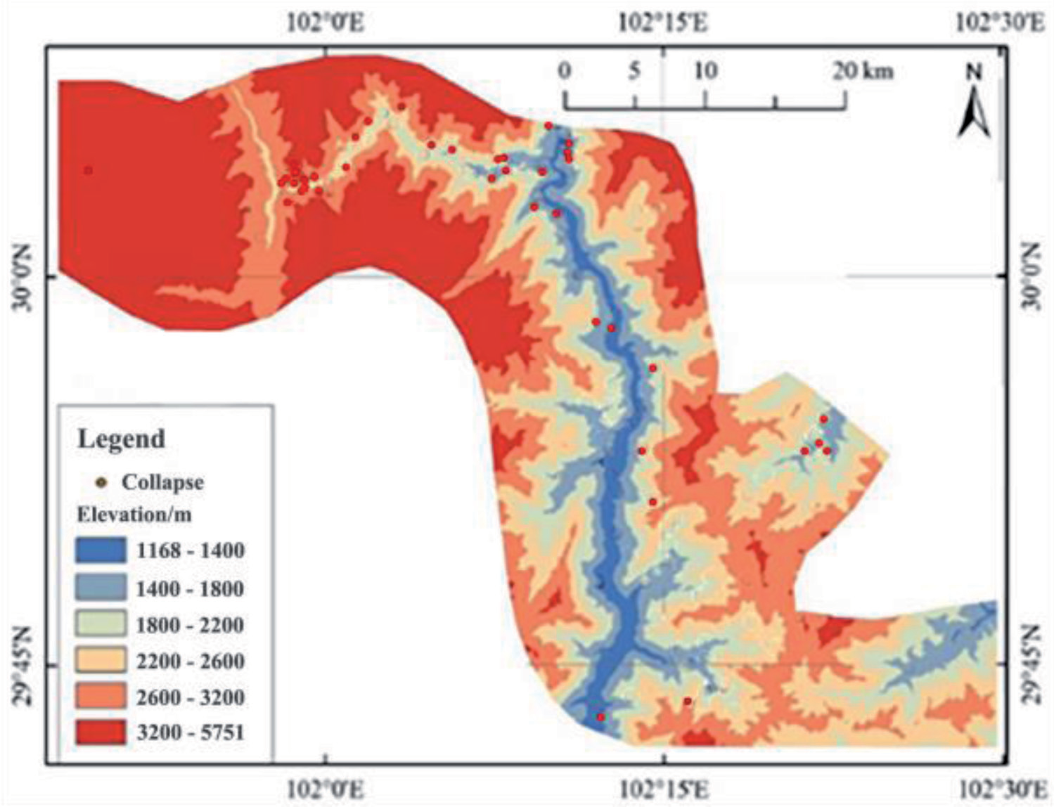
The relationship between the distribution of geological disasters in the study area and the elevation is shown in Fig.1. The collapse disasters are mainly distributed along the Kangding River in the northwest. The elevation ranges with the highest number of collapse disasters are 2600 - 3200 m, 1800 - 2200 m, and 1400 - 1800 m, respectively. A total of 34 collapses are distributed, accounting for 81% of the total number of collapses.
Slope Gradient
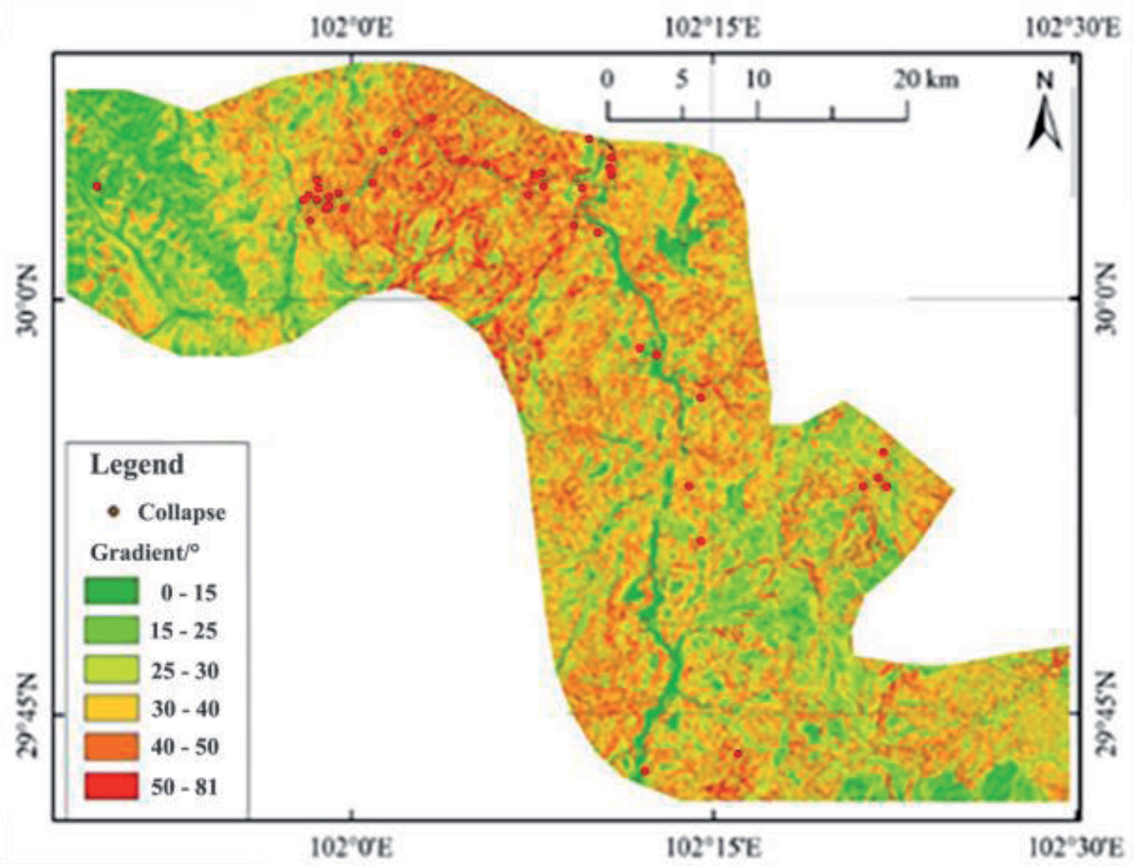
The steeper the slope gradient, the more it is prone to geologic hazards. The slope significantly affects the stress redistribution and stress differentiation process of the slope rock and soil mass. With the steepening of the slope, the larger the distribution range and value of the tensile stress at the trailing edge of the slope, the more significant the shear stress concentration at the foot of the slope. The high and steep slope is not conducive to the stability of the slope rock and soil mass. The relationship between geological disaster distribution and slope is shown in Fig. 2.
It shows that the slope in the study area is mainly between 15°and 50°, and the slope of 30°~ 40°is the most developed, followed by the slope of 40°~ 50°. The study area is a typical deep - cut gorge geomorphology. The slope ranges with the largest number of collapse disasters are 40°~ 50°, 30°~ 40°, and 50°~ 81°, respectively. A total of 30 collapses are distributed, accounting for 71.4% of the total number of collapses. The number of collapse disasters increases with the increase of slope.
Slope Orientation
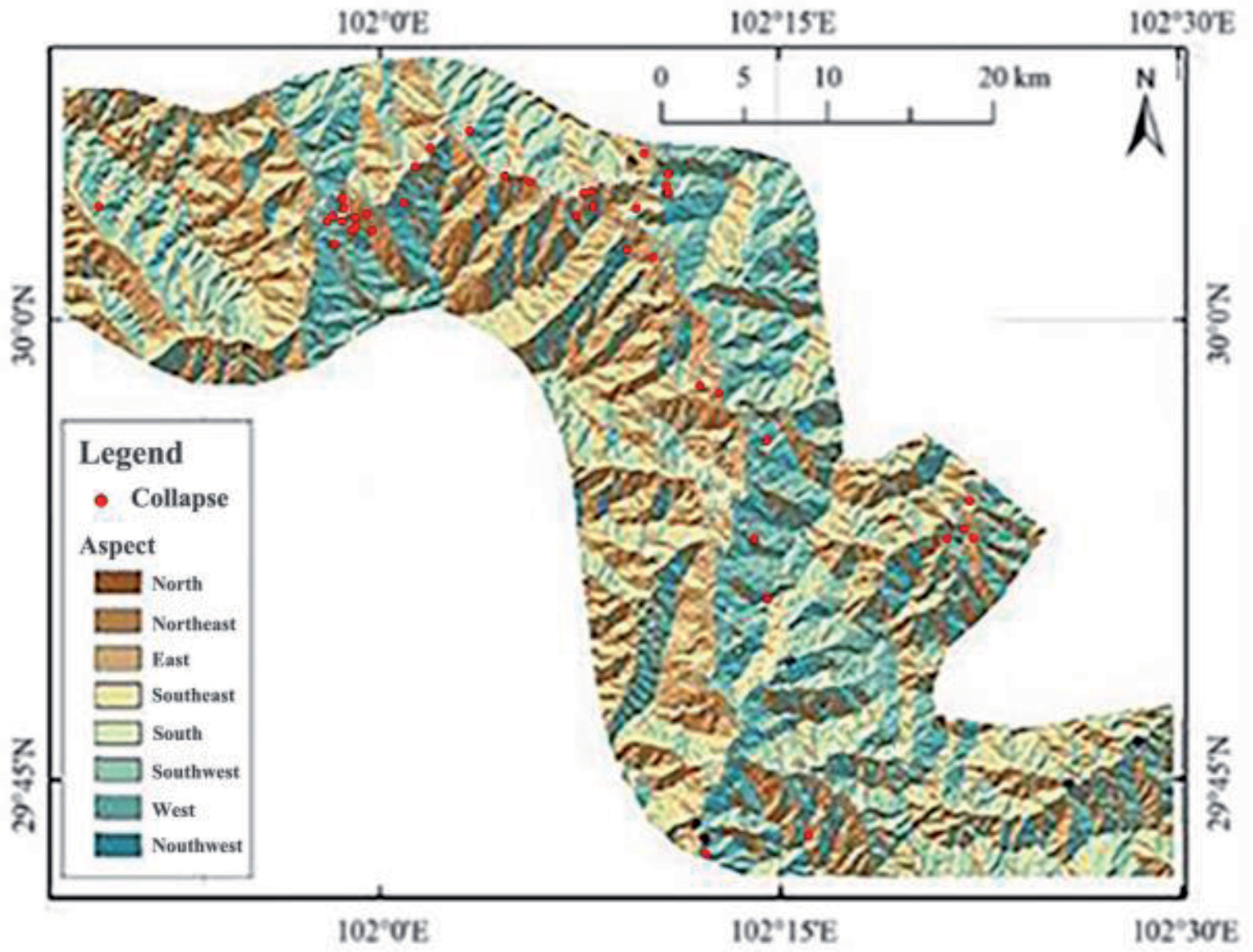
The slope direction largely determines the time and intensity of the slope to receive solar radiation. In addition, it affects the development of vegetation on the slope surface and the degree of weathering denudation. The distribution of geological disasters and slope direction in the study area is shown in Fig. 3.
It shows that the slope direction in the study area is basically evenly distributed, and the distribution of geological disasters by slope direction does not show significant regularity. The slope areas have a lot of collapse disasters with a total of 23 collapses, accounting for 56.1% of the total number of collapses, which are successively southeast, northwest, and southwest.
Geological Structure
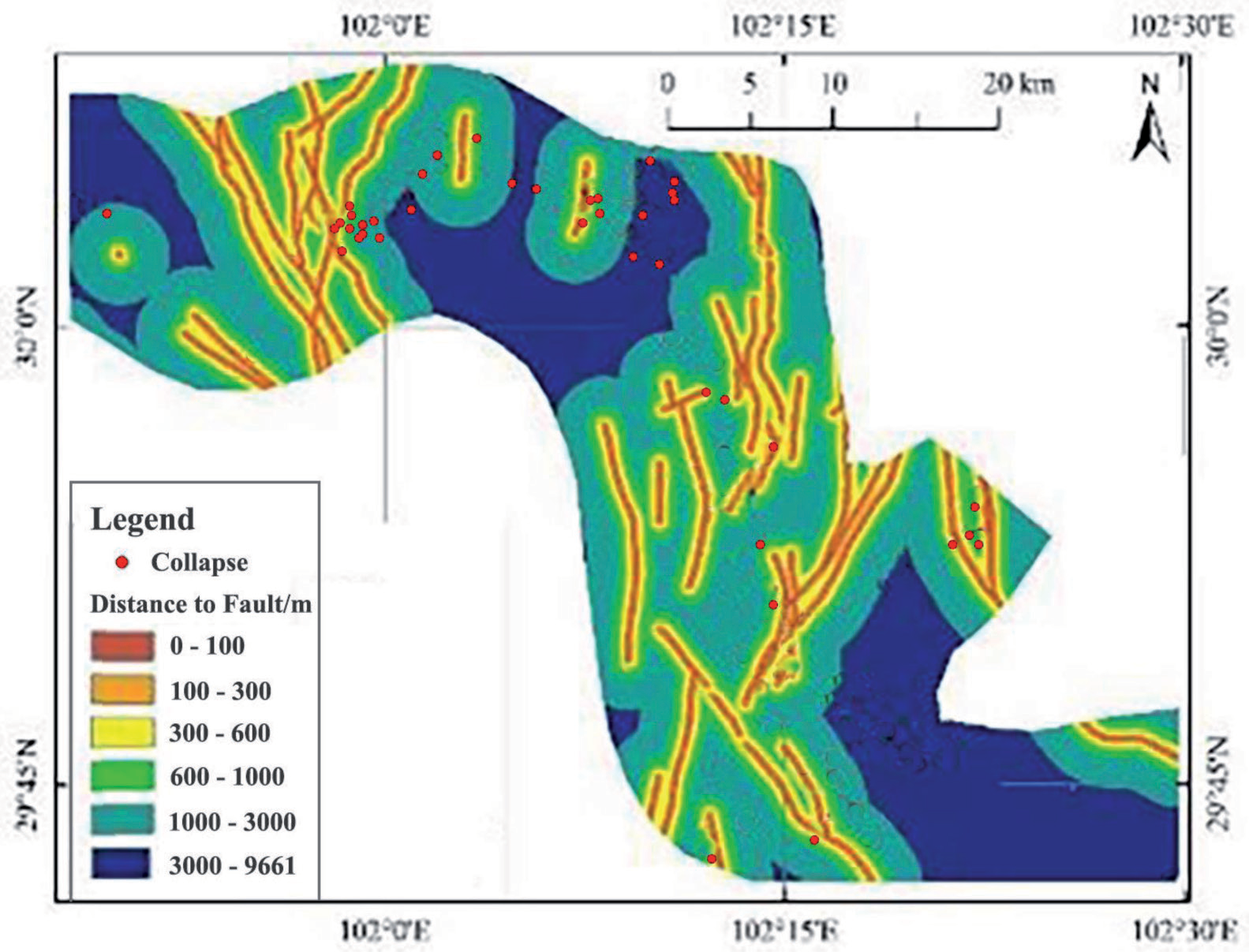
The geological structure in the study area is complex and the faults are developed. Generally, the closer the distance from the fault is, the stronger the influence of tectonic action on the stability of rock and soil mass is, and the more prone it is to lead to geological disasters. In this paper, the distance from the fault lines is used to measure the influence of tectonic action on the stability of rock and soil. The distribution map of collapse disaster development and fault distance in the study area is shown in Fig.4. It shows that there are 46 geological disasters distributed in the 1000 - 3000 m distance from the faults in the study area, accounting for 30.9% of the total number of geological disasters; besides, there are 33 geological disasters in the range of 3000 - 9661 m, accounting for 22.1% of the total number of geological disasters. The geological disasters in the remaining sections are basically evenly distributed.
Rock Formation
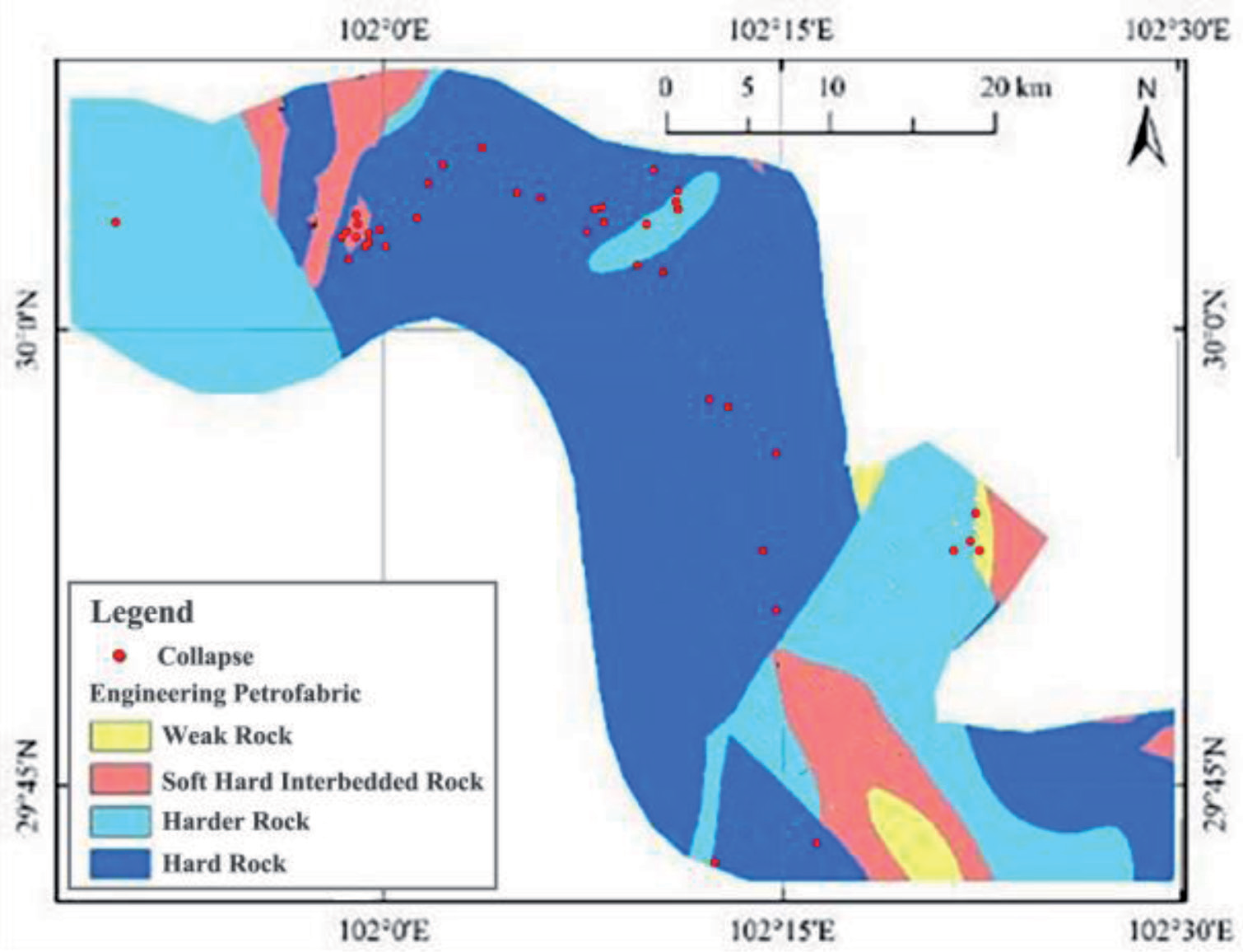
According to the formation age of strata and lithology, the strata in the study area are divided into four categories: rigid formation complex, relatively rigid formation complex, soft-hard alternant strata, and weak lays. The distribution map of geological disasters and engineering rock groups in the study area is shown in Fig. 5.
It shows that the number of engineering geological formation complexes in the study area is rigid formation complex, relatively rigid formation complex, soft-hard alternant strata, and weak lays. These proportions are 58.8, 30.1%, 9.3%, and 1.8% respectively. The collapse disasters in the study area are mainly developed in the early Proterozoic acid rock, the Paleoproterozoic acid rock, the Nanhua period acid rock and the Kangding group complex. The lithology is mainly composed of quartz diorite, granite, amphibolite, and other rigid or relatively rigid rocks. These rigid rock masses can form steep slopes, which are conducive to the concentration of tensile stress at the trailing edge of the slope. The rock can promote tensile fractures at the trailing edge of the slope, which is prone to collapse under rainfall conditions.
Annual Rainfall
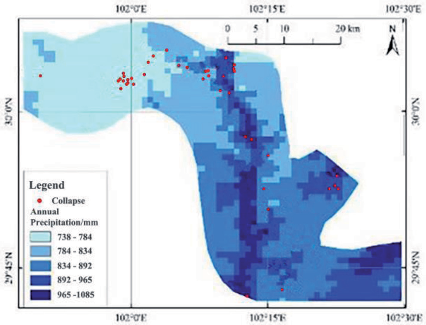
Rainfall can significantly reduce the stability of slope rock and soil mass, which is an important geological disaster inducing factor. This paper uses multi-year average rainfall for analysis. The distribution of collapse disasters and annual rainfall in the study area is shown in Fig.6. It shows that the collapse disasters in the study area are mainly distributed in the area with rainfall of 834 - 965mm, and the number of collapses in this area is 22, accounting for 52.4%.
Discussion
Hazards to Power Transmission Projects Created by Collapses
Some scholars have divided the influence of geological disasters on power transmission projects into four typical hazard modes in combination with the influence form, inducing factors, threat objects, and influence scope of geological disasters on power transmission projects [26-27]:1) threaten the safety of substation site, resulting in equipment damage and interruption of power supply in the area.2) threaten substation access roads and other ancillary facilities, affecting the normal operation and maintenance of substations. 3) damage to the transmission tower, resulting in line interruption; 4) the earthquake induced regional geological disasters, resulting in large regional power grid paralysis. According to the remote sensing interpretation and field survey of geological disasters along the Erlang Mountain Zheduo Mountain transmission line corridor, the study area has the most landslide disasters, with a total of 61 landslide disasters developed, accounting for 40.94% of the total disasters.
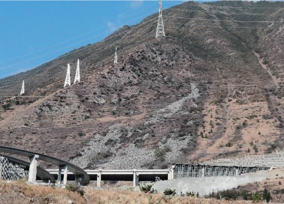
Remote sensing interpretation and on-site geological disaster investigation shows that the influence of the current collapse disaster development along the transmission corridor in the deep – cut gorge area of Erlang Mountain – Zheduo Mountain Dadu River on the power transmission project is mainly to threaten the stability of the tower and its foundation. The typical disaster characteristics and the form of action on the power transmission project are as follows:
The No.4 collapse is located on the edge of Yakang Expressway. The geographic coordinate is 102° 21′ 20′′, 29° 58′ 12′′, and the slope direction is 95°. The remote sensing image and on - site investigation can see a clear collapse boundary, which belongs to medium-sized rock collapse (Fig. 7). The rock mass in the collapse source area of the No.4 collapse is steeply inclined. The collapse deposits are developed under the current conditions. The formation mechanism should be sliding or falling collapse. The stable state under the current conditions is basically stable to less stable. There are multiple transmission tower foundations arranged above it. Rainfall will reduce the stability of the collapse. There is the possibility of instability, which poses a serious threat to the stability of the transmission tower, and even leads to the collapse of the transmission tower.
Conclusions
This paper takes the transmission corridor along the Erlang Mountain - Zheduo Mountain Dadu River deep - cut gorge area as the research object. The development characteristics of collapse disaster and influence on power transmission projects in the area are studied by means of remote sensing interpretation and geological disaster investigation. The following conclusions are obtained:
(1) There are 42 collapse disasters in the study area. The collapse disasters are mainly developed along the Kangding River and the Dadu River which are mainly small and medium - sized rock collapses. They are developed in Early Proterozoic acid rocks, Paleoproterozoic acid rocks, Nanhua period acid rocks, and the Kangding group complex. The lithology is mainly rigid or relatively rigid rocks such as quartz diorite, granite, and amphibolite.
(2) The main factors controlling the formation of collapse disasters in the study area are topography, slope direction, geological structure, engineering geological formation complex, annual rainfall, etc. In the study area, the collapse disasters are mainly distributed in the elevation below 2200 m, and the slope gradient of the collapse disaster is mainly between 40° and 50°. The slope direction is basically evenly distributed. The distribution of the collapse disasters by the direction of the slope does not show any significant pattern. The collapse disaster in the study area is the most developed in the distance from the fault in the interval of 1000 - 3000 m.
(3) Erlangshan – Xuanduo Mountain Dadu River deep – cutting gorge area along the transmission corridor of the current collapse disaster development on the transmission project is mainly to threaten the stability of the tower and foundation. Under the current situation, the stable state of disaster is basically stable ~less stable. Rainfall, excavation, human engineering activities, or earthquakes might lead to a serious threat to the stability of transmission towers and their foundations.

