

Introduction
The establishment of protected areas is an important way to conserve global biodiversity [1], and national parks are one of the most extensive types of protected areas, playing a significant role in conserving biodiversity, historical and cultural heritage, and maintaining ecosystem services within their spatial boundaries [2]. In October 2021, the 15th Conference of the Parties to the United Nations Convention on Biological Diversity (COP 15) in Kunming, China, officially announced the establishment of the first five national parks in China, marking China’s entry into the ranks of countries with national park systems. The pilot projects include the Three-River-Source National Park, the Wuyishan National Park, the Giant Panda National Park, the Northeast China Tiger and Leopard National Park, and the Hainan Tropical Rainforest National Park. In addition, China has selected a total of 49 national park candidate sites in the National Park Spatial Layout Plan, setting out a plan that envisages the creation of the world’s most extensive national park system by 2035. Meanwhile, Huangshan National Park is also on the list of 49 national park candidate sites [3]. In recent decades, the largest urbanization in human history has occurred in emerging countries, such as China, and studies have demonstrated that human-land conflicts brought on by urbanization can cause huge regional losses of biodiversity, forest carbon sinks, and other ecosystem services [4]. Furthermore, China’s eastern and southern regions have minimal ecosystem coverage, rendering them more vulnerable to habitat fragmentation, population stress, and economic pressure [5]. Hence, the issue of how to establish national parks in human-land conflict zones must be addressed urgently.
Determination of boundary extent is the priority in the establishment of national parks. In landscape ecology, boundary delineation is essential for the protection of ecosystem integrity by identifying areas of excess heterogeneity between areas of relative homogeneity at a particular scale [6]. The Huangshan National Park construction area is located in the Yangtze River Delta urban agglomeration, one of the five largest urban agglomerations in China, which has become the region with the most intense human-land conflict due to rapid urbanization [7]. Therefore, this study focuses on Huangshan National Park, and how to enhance biodiversity conservation while minimizing the impact on human society is the key issue to be addressed.
There are currently more studies on the boundary delineation between national parks and protected areas. The guidelines for this are mainly based on the protection of regional ecological resources, regional topographic integrity, ecological community distribution, and important ecological lands [8, 9], while the delineation methods include species genetic evolution prediction [10], flagship species richness measurements [11], ecosystem type monitoring [12, 13], ecosystem service measurements [14], landscape diversity calculations [15], and local community participation in delineation [16]. The frequent human activities have caused negative impacts on the ecological environment around and inside the national parks, and have posed great difficulties for the boundaries delineation and subsequent management of national parks [17]. National park planning across the world will have to cope with a similar management issue, namely how to resolve the conflict between the development of national parks and the surrounding communities, tourists, and other stakeholders, which is also a conflict between development and conservation.
Overall, there is still a large knowledge gap in the current delineation of national park boundaries. Most of the existing research tends to draw boundaries primarily on the conservation of species and landscapes, however, some of it also considers the attitudes of local communities towards the scope of national parks. Although national parks and protected areas’ boundaries have some validity, the trade-off between ecological resource conservation and community economic development was less considered during the delineation process, thus most of the protected areas have failed to achieve the desired purpose of balancing conservation and development. Moreover, the size of the national park protection area is typically determined based on expert determination or policy orientation, and the threshold of the protection area rarely considers the region’s human-land conflict relationship, which is not conducive to the construction and sustainable development of national parks.
Systematic conservation planning, as the mainstream theory of protected area planning, was first proposed by Margules and Pressey [18]. To alleviate the human-land conflicts prevailing in protected areas, it underlines the necessity to consider the socioeconomic and conservation costs of the area while determining the priority protected areas. Additionally, it is built on complementary algorithms that combine data on biodiversity components and conservation costs, which direct conservation management actions to identify boundaries, and also adopt a multidisciplinary approach to master planning of priority biodiversity conservation areas, making conservation actions more focused and effective [19]. GIS technology has made it easier to refine system conservation planning methods, facilitating the development of a series of siting software to solve increasingly complex boundary delineation problems [20]. C-Plan [21], Zonation [22], Marxan [23], and other common siting software are currently in use. The Marxan model was widely used in the early days of marine conservation planning [24-26], and is currently used in the boundaries delineation of terrestrial protected areas at both global and regional scales [27- 29].
The Huangshan National Park construction area is centered on the Huangshan National Scenic Area, which is situated inside the Southern Anhui Mountainous and Hilly Ecological Region, serving as an important part of the hilly mountainous area in southern China. In 1992, Mount Huangshan was inscribed on the World Heritage List by the UNESCO (United Nations Educational, Scientific and Cultural Organization) World Heritage Convention, which described it as “the loveliest mountain of China”. As can be seen, Huangshan National Park possesses extremely high ecological values. However, because it lies in the Yangtze River Delta, a region that is experiencing rapid economic growth, the delineation of the national park boundary requires balancing ecological conservation with socioeconomic development. Therefore, this study takes the southern Anhui mountainous and hilly ecological region as the research area, and firstly, we evaluate the current ecological protection status, to prepare for the subsequent boundary delimitation work. Secondly, this study weighs the trade-offs between conservation and development, sets the conservation features of species, ecosystems, and landscapes at three levels, counts the intensity of human activity as a conservation cost, and then computes each planning unit’s irreplaceability value and protection advantage based on the conservation features and cost. Finally, this study determines the optimal protection ratio of the national park through marginal benefits analysis, and delineates the boundary of Huangshan National Park, aiming to provide scientific experience and reference for the establishment of national parks in human-land conflict areas in China.
Methods
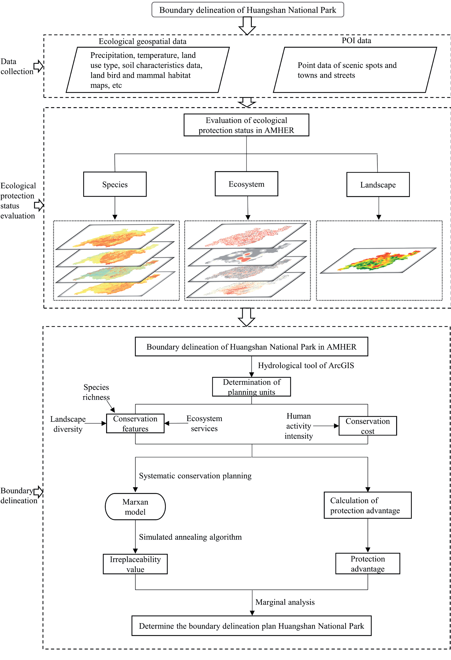
The study uses Huangshan National Park as its research subject and develops a set of detailed national park boundary delineation guidelines (Fig. 1), which can also be used to delineate park boundaries in other areas where people and land conflict. This will enable China to establish the largest national park system in the world.
First of all, this paper takes the Southern Anhui Mountainous and Hilly Ecological Region as the study area and evaluates the current status of ecological protection, including species, ecosystems, and landscapes, which are characterized by species richness, ecosystem services, and landscape diversity, respectively for the subsequent study. After that, the study incorporates the data of human activity intensity as the conservation cost, species richness, ecosystem services, and landscape diversity as the conservation features, calculates the protection advantage value of each planning unit, and uses the systematic conservation planning software Marxan to calculate the irreplaceability value of each planning unit. Finally, this research determines the protection ratio based on the irreplaceability value and completes the boundary delineation of Huangshan National Park by analyzing the marginal benefits of protection advantages under different protection ratios. The next sections provide a detailed description of each step.
Study Area
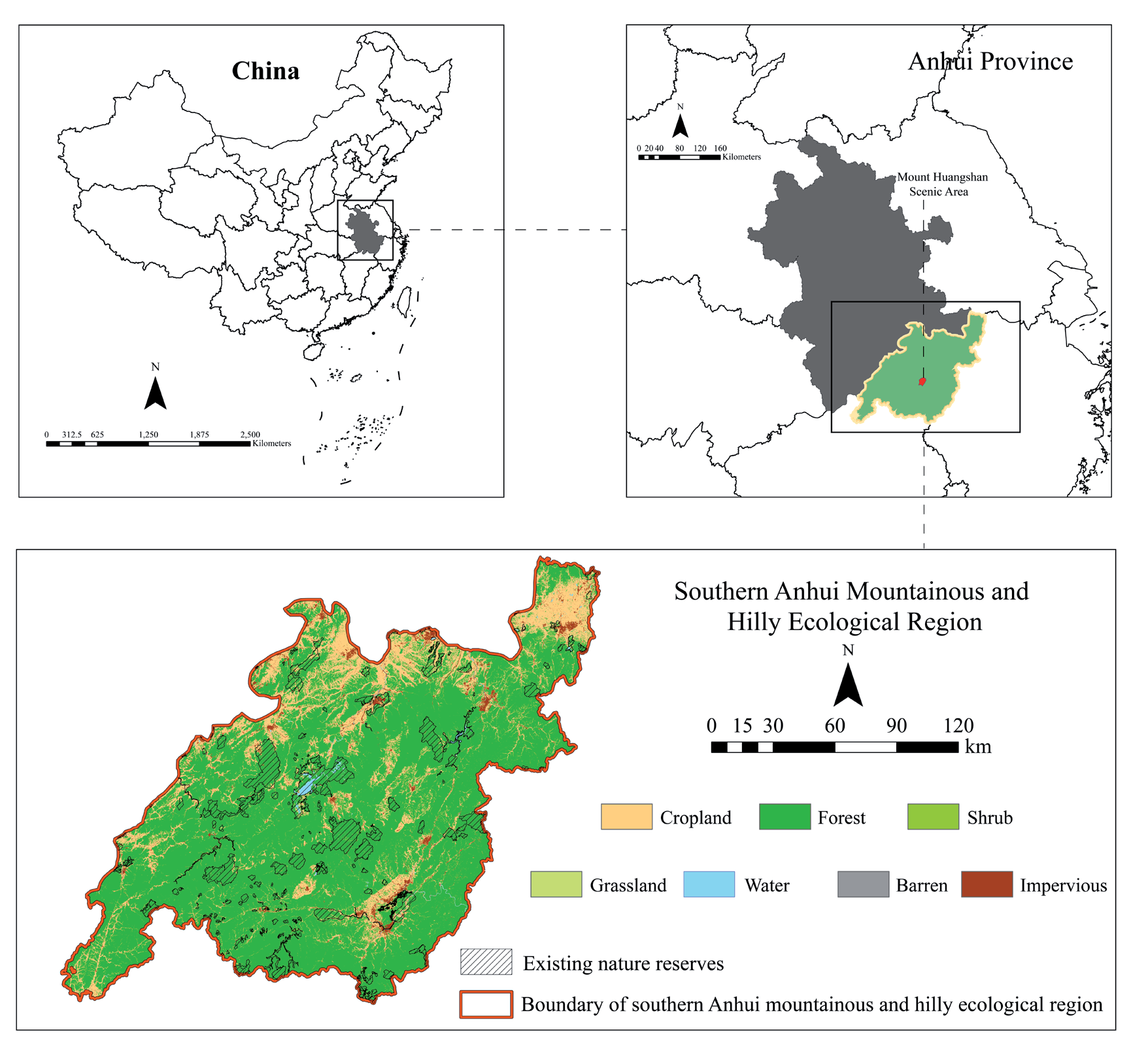
This study takes Huangshan National Scenic Area as the study area. While considering the geographical correlation and the integrity of the ecosystem, the Southern Anhui Mountainous and Hilly Ecological Region are selected as the assessment area of Huangshan National Park, according to the results of the ecological function zoning in Anhui Province. Located in the south of Anhui Province, between 29°40′-31°21′N, 116°64′- 119°64′E, connected to the Yangtze River in the north and bordered by Jiangsu, Zhejiang, and Jiangxi provinces in the south, the Southern Anhui Mountainous and Hilly Ecological Region is the main component of the southern hilly mountainous region in China and the most biodiversity-rich natural geographic area in Anhui Province [30] (Fig. 2). The landscape is dominated by hills, with dramatic topographic undulations, and the highest elevation reaches 1816 meters. The climate is a subtropical humid monsoon climate with abundant rainfall and light, and four distinct seasons. The land use type in the ecological zone of the hills of southern Anhui is mainly woodland, with the proportion of woodland reaching 66.49%, with a great overall ecological environment. There are 167 existing forest parks, wetland parks, scenic spots, geoparks, and other kinds of nature reserves in the region.
Data Source
This paper mainly adopts spatial data for the research of national park boundaries and zoning. The spatial data mainly include precipitation, temperature, land use type, soil characteristics data, digital elevation model, NDVI, land bird and mammal habitat maps, human activity intensity data, and POI data in the South Anhui Mountain and Hill Ecological Zone.
The 2020 temperature data is from the National Tibetan Plateau Scientific Data Center (https://data. tpdc.ac.cn/zh-hans/data/71ab4677-b66c-4fd1-a004- b2a541c4d5bf/) with a spatial resolution of 1 km. The 2020 precipitation data is from Science Data Bank (https://cstr.cn/31253.11.sciencedb.01607) with a spatial resolution of 1 km. The 2020 land use data is obtained from the Landsat-based annual Chinese land cover dataset (https://zenodo.org/record/). 5816591#. YvttjBxByUk) with a spatial resolution of 30m. The 2020 soil characteristics data is from the Harmonized World Soil Database (https://webarchive.iiasa.ac.at/ Research/LUC/External-). World-soil database/HTML/) with a spatial resolution of 30 m. The 2020 digital elevation model and NDVI data are from the Data Center of the Chinese Academy of Sciences (https://www.resdc. cn/Default.aspx) with a resolution of 90 m and 1 km, respectively. Terrestrial habitats in the hilly ecoregion of southern Anhui Bird and mammal habitat maps are from previous research [31], and the database contains species richness data for all mammals and birds, red-listed mammals and birds, with a spatial resolution of 100 m. Terrestrial systems data is from Data Center in NASA’s Earth Observing System Data and Information System (https://sedac.ciesin.columbia.edu/ data/set/lulc-human-modification-terrestrial-systems/ data-download), the dataset includes 13 indicators of human activities such as population density, urbanized area, crops, and nighttime light data, with a spatial resolution of 1 km. POI is a location identifier in the navigation map, which can visually reflect the area’s production and life information. The POI point data in the study area are from the web crawler using the Gaode Map API, and the year of all acquisitions is 2020.
Conservation Features and Conservation Cost Calculation
National parks are widely considered to be the core of biodiversity conservation strategies [32]. Biodiversity includes multiple levels and levels of diversity, with four main levels: genetic diversity, species diversity, ecosystem diversity, and landscape diversity. Among them, genetic diversity data are difficult to quantify due to the large area of Huangshan National Park construction area. Therefore, this paper introduces three levels of biodiversity indicators of species, ecosystem, and landscape to characterize conservation features in the national park boundary delineation process. In studies related to protected area delineation, conservation costs are often indicated using human activity intensity [5, 14], so this paper uses human modification of terrestrial systems data to characterize the cost of delineating Huangshan National Park.
Fig. 1.
Methodological framework. Note: “AMHER” is the abbreviation for the Southern Anhui Mountainous and Hilly Ecological Region.
Planning Unit Determination
The watershed scale is the basic territorial unit with water as the link and the complex of natural and ecological-economic and social systems [33]. This study selects the watershed as the smallest planning unit of Huangshan National Park construction area in this study, mainly because of the integrity of the natural geographic unit and ecosystem, which can highlight the comprehensive issues of human-land harmony at the watershed scale and facilitate management. The watershed unit as the planning unit is calculated by the hydrological tool of ArcGIS.
Species Richness Data
The species richness data contains all mammals and birds, IUCN Red-Listed mammals and birds from the Terrestrial and Bird and Mammal Habitat Map databases. Our study sets the weights using the expert scoring method: red-listed mammals (30%), red-listed birds (30%), all mammals (20%), and all birds (20%). Based on the set weights, the final species richness data is obtained by ArcGIS overlay analysis.
Ecosystem Services Measurement
The Territorial Ecological Restoration Plan of Anhui Province (2021-2035) proposes that the Southern Anhui Mountainous and Hilly Ecological Region is rich in natural and humanistic landscapes, with relatively well-preserved natural vegetation and wildlife, diverse and important ecosystem service functions [34]. However, the soil erosion surrounding water-containing places is particularly severe because of the unnatural structure of forests in some areas. The woodland area has also decreased in some locations as a result of the influence of tourism development, urban and rural construction, and other human activities, which has a detrimental effect on water conservation and carbon storage services. In addition, it is proposed within the document to build the international cultural tourism demonstration area in southern Anhui and promote the ecological tourism economy. Therefore, our study considers the above reasons and select water conservation, carbon storage, soil conservation, and cultural ecosystem services as the evaluation index of integrated ecosystem services.
Water conservation is the process and capacity of ecosystem water retention over a certain time and space scale, which is calculated using the water balance equation [35].
WS is water conservation supply (t); Pi is precipitation (mm); Ai is the area of the ith land use (m2); ETi is potential evapotranspiration (mm); Ri is surface runoff (mm), calculated by multiplying precipitation and surface runoff coefficient, which is described in the literature [36].
Soil conservation is mainly to reduce erosion and prevent soil nutrient loss, which plays an important role in preventing regional ecological degradation [37]. In this study, calculations are based on the modified soil erosion equation [38]:
Ac is soil retention (t/hm2·a); Ap is potential soil erosion; Ar is actual soil erosion; R is rainfall erosion factor (MJ·mm/hm2·h·a); K is soil erodibility factor (t·hm2·h/hm2·MJ·mm), L and S are terrain factors. Where L represents the slope length factor, and S represents the slope factor, to better reflect the overall shape of the terrain, the terrain factor can also be replaced by undulation LS. C is the vegetation factor.
Carbon storage is calculated based on the carbon module of the InVEST (Integrated Valuation of Ecosystem Services and Trade-offs) model, which accounts for the supply of carbon storage services by calculating above-ground carbon density, below-ground carbon density, soil organic matter, and dead organic matter for different land use types [39]. Research demonstrates that both biomass carbon density and soil carbon density show a significant correlation with mean annual precipitation [40, 41]. Therefore, the biomass carbon density and soil carbon density in the Southern Anhui Mountainous and Hilly Ecological Region are corrected based on the average annual precipitation. The carbon storage is calculated as:
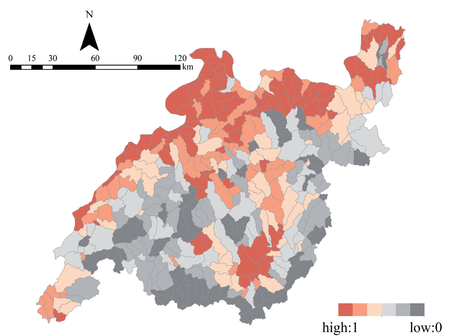
CS is the supply of carbon storage services, Cabove, i, Cbelow, i, Cdead, i, and Csoil,j represent the above-ground biomass, below-ground biomass, dead organic matter, and carbon density of soil carbon pools of the ith land use type, respectively, and Ai is the area of the ith land use type.
As an important component of ecosystems, cultural ecosystem service may safeguard and enhance resource values, as well as improve the well-being of residents [42]. In this study, the quantification of cultural ecosystem service is achieved through kernel density analysis of POIs of sites in the mountainous areas of southern Anhui Province [43] by ArcGIS 10.8.
In the research, ArcGIS spatial overlay analysis is applied to evaluate the importance of integrated ecosystem services in the study area. Four indicators of water conservation, soil conservation, carbon storage, and cultural services are standardized, and then equal weights and sums to obtain the evaluation results of integrated ecosystem services [14, 44].
Landscape Diversity Index Calculation
Landscape diversity is characterized using the Shannon Diversity Index [45, 46]. Considering that impervious surfaces and cultivated lands are not naturally occurring lands and should not be protected, impervious surfaces and cultivated lands are reclassified as grasslands for calculation [15] and calculated as follows:
SHDI is the Shannon diversity index, pi is the area share of patch types in the landscape, and M is the number of patch types in the landscape. The value of 0 indicates that the landscape contains only one patch, and its value increases as the area of different types of patches in the landscape increases and the number of patches increases.
Conservation Feature and Cost Data Calculation
The species richness data, integrated ecosystem services, and landscape diversity data are standardized and then equal-weighted superimposes to obtain conservation features, and the human modification of terrestrial systems data is used as conservation cost. The mean values of conservation features and costs for each watershed unit are calculated using the Zonal Statistics as Table in ArcGIS, and standardize to obtain the conservation feature and conservation cost data for this study.
Protection Advantage Measurement
In this paper, the protection advantage is defined as the marginal benefit of a watershed unit being included in the national park boundary [47], with the following equation:
Where PAi is the protection advantage of each watershed unit, CFi and CCi are the normalized average conservation feature and average conservation cost of each watershed unit, respectively.
Calculation of Watershed Unit Irreplaceability Values Based on Marxan
The Marxan software employs a simulated annealing algorithm, which compares an equivalent number of replaceable places with the irreplaceable locations at each stage to find effective solutions [48, 49]. Provide Marxan with reasonable species, habitat data, or some other characterization data to guarantee that the protected area will meet the user-defined conservation objectives at minimal cost.
The watershed-scale conservation feature and conservation cost data are entered into the Marxan software for calculation, while Marxan is run to obtain two results, one for the priority conservation units and the other for the non-substitutability results. In this study, we mainly use the irreplaceability results for boundary delineation. First, the Marxan model’s iteration number is set to 10,000, and each watershed planning unit in the outcome has a value between [0] and [10000], which indicates how many times it has been chosen as the best planning solution. And the irreplaceability of the planning unit is measured by how frequently each watershed unit is selected. The more irreplaceable a site is, the more important it is for conservation, and the more likely it is to be chosen repeatedly.
Results
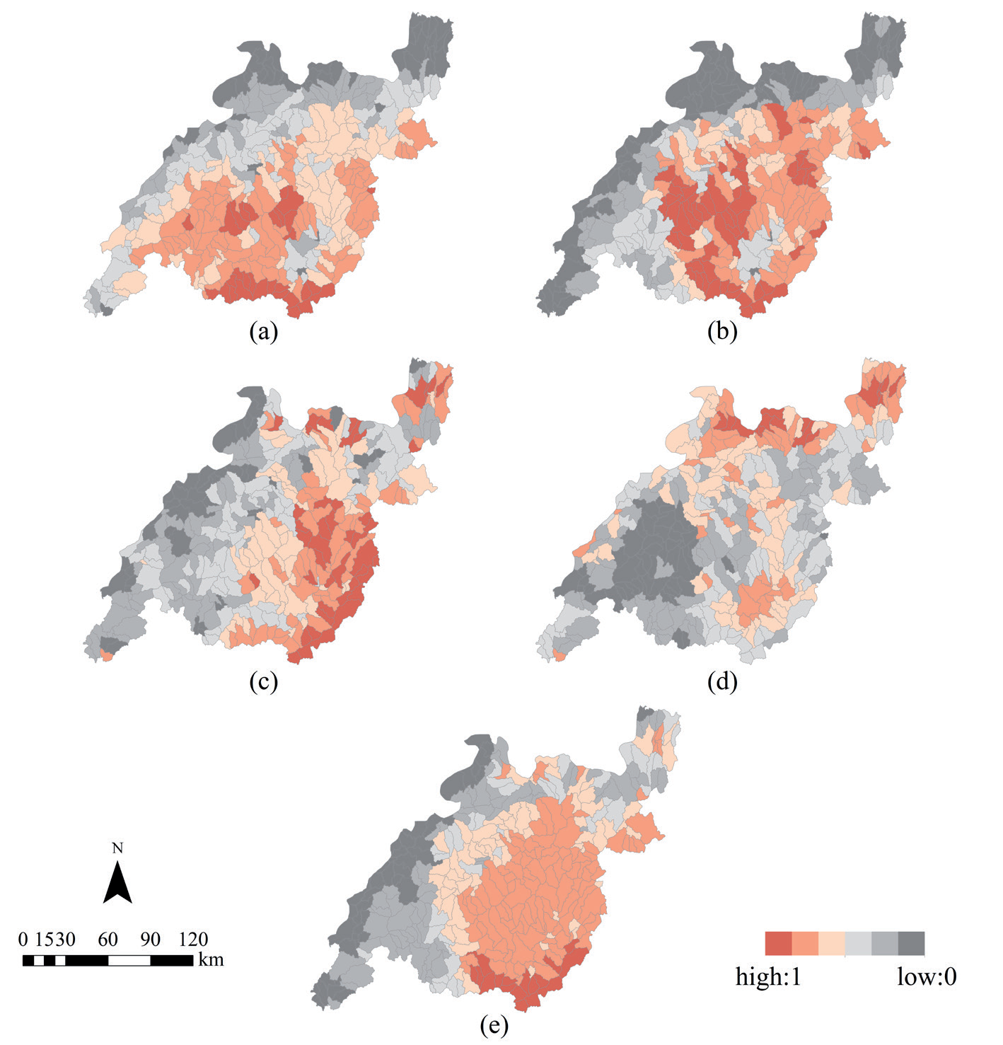
Species Richness Feature
The watershed units in the study area are divided by the ArcHrydro tool in the Spatial Analyst module of ArcGIS software, and finally, 350 watershed units are extracted according to spatial distribution. As shown in Fig.3a, the southern part of the Mountains in Southern Anhui is home to the majority of the high-value mammal species richness areas, while the low-value areas are less distributed in the northeastern part. According to Fig. 3b, the high-value areas of globally threatened mammal species richness are mainly concentrated in the southeastern part of the South Anhui Mountains, whereas the western and northeastern regions have lower values. The primary reason is that the Southern Anhui Mountainous and Hilly Ecological Region’s southern portion has a higher elevation than its northern portion, and has a higher proportion of woodlands, which is more suitable for mammal habitat. Additionally, the northern part of the mountainous and hilly ecological region has a significant amount of arable land and urban construction sites, and human activities like environmental pollution, resource overuse, habitat fragmentation, and anthropogenic hunting and poaching will negatively affect the diversity of mammal species.
The species richness distribution features of birds and birds that are endangered globally are comparable, as shown in Fig. 3(c,d). Due to the northern section of the ecoregion’s proximity to China’s longest river, and near the southern Yangtze River, the high-value regions are primarily concentrated in the northern part of the Southern Anhui Mountainous and Hilly Ecological Region. And therefore numerous small micro-wetlands are also distributed in this area, which provide suitable habitats for birds. Although human agricultural activities are more intense in this area, the farmland is mainly paddy fields, which, from a dialectical point of view, also relieves foraging pressure for birds and serves as a stepping stone during migration.
The Southern Anhui Mountainous and Hilly Ecological Region’s species richness, as determined by weighted superposition, is depicted in Fig. 3e). The high-value areas are primarily found in the eco-region’s central and eastern regions, while some areas in the west have lower species richness.
Ecosystem Service Feature
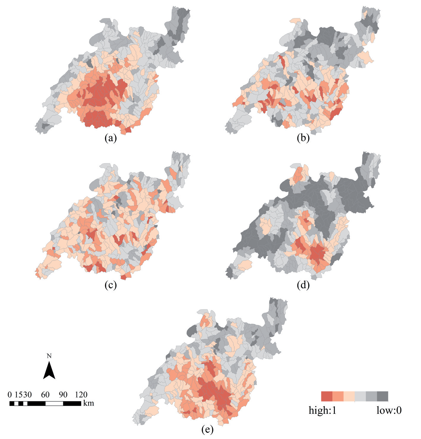
The Southern Anhui Mountainous and Hilly Ecological Region’s high-value water conservation zones are primarily concentrated in the southwest (Fig. 4a). These regions receive high rainfall and rich vegetation, thus their capacity to conserve water is strong. According to Fig. 4b, the eco-region’s overall degree of soil conservation is relatively uniform, and from north to south, it steadily increases in terms of spatial distribution. The northern part of the region is relatively flat and suitable for human activities. Urbanization and construction activities lead to the increase of impervious surfaces, thus the soil conservation function is weaker. On the contrary, the high-value areas are mainly distributed in the mountainous areas in the south, which are more influenced by topographic factors. The majority of the land in the region is forest, which results in a high level of overall carbon storage service (Fig. 4c). Conversely, areas with weak carbon storage are dispersed throughout each municipality’s construction land, water area, and unused land. The high-value areas of cultural services within the Southern Anhui Mountainous and Hilly Ecological Region are mainly located in the southern part of the study area (Fig. 4d). The southern half of the research region is rich in attractions and has a high degree of aggregation. And the high-value locations are surrounded by well-known scenic spots such as Taiping Lake Scenic Spot, Huangshan Mountain Scenic Spot, and Qi Yun Mountain Scenic Spot, which have high recreational value.
Fig. 3.
Distributional features of mammal richness a), IUCN red-listed mammal richness b), bird richness c), IUCN red-listed bird richness d), and combined species richness e).
In general, the results of ecosystem service distribution in the Southern Anhui Mountainous and Hilly Ecological Region have significant spatial heterogeneity, with the integrated ecosystem service values decreasing from north to south (Fig. 4e). The central and southern parts are mainly dominated by high-value areas with relatively high regional ecosystem importance, while the importance of major ecosystems in the remaining regions is relatively low.
Landscape Diversity Feature
After reclassifying the cropland and impervious surface as grassland, five land use types exist in the study area, namely forest, shrubland, grassland, water, and barren. The results of the Landscape Diversity Index (LDI) are shown in Fig. 5. The high values of the LDI are mainly found in the southern periphery of the study area, while the northern area has a lower LDI. By overlaying with the land use data, our study found that there are various types of woodland, shrubland, grassland, unused land, and water area scattered in the southern study area, so the landscape diversity index is relatively high. However, the northern portion consists mainly of grassland and woodland, with fewer types of land use and thus a lower landscape diversity index. The landscape diversity index in the central region is similar to that in the northern region, which is generally low, but there are sporadic high-value units. In general, SHDI low-value areas tend to consist of two or fewer land use types, while SHDI high-value areas have more types of land use types and a more balanced proportion of each land use type, and thus should be protected as a priority.
Irreplaceability Values and Protection Advantage Results
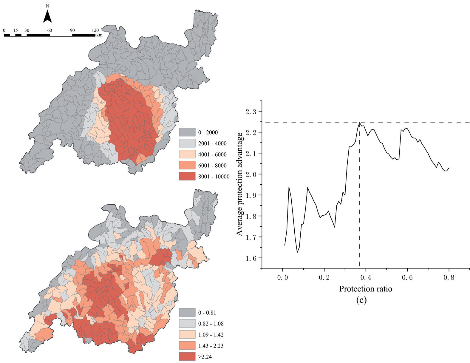
Figs 6(a,b) display the irreplaceability values and protection advantage outcomes. In South Anhui’s mountainous region, the high values are primarily concentrated in the central and southern areas, while the irreplaceability values in the western and northeastern regions are lower. The results of irreplaceability values and protection advantages are different, and the high value of protection advantages is more concentrated in the west and south of the study area, while some high-value areas are distributed in the northeast, and the advantages in the north are also relatively low.
Fig. 4.
Distributional features of water conservation a), soil conservation b), carbon storage c), cultural services d), and integrated ecosystem services e).
This study analyzes the relationship between the irreplaceability value and the protection advantage, to determine the threshold value of the protection ratio in the process of national park boundary delineation. The size of the irreplaceability value determines the priority conservation ranking, and planning units with high irreplaceability values are chosen as conservation units. The protection ratio is the proportion of the number of conservation units to the total number of planning units, and it is investigated how it relates to the conservation units’ average protection advantage (Fig. 6c). The study discovers that the average protection advantage fluctuates upward as the ratio rises between 0% and 37%, peaks when the index reaches 37%, and declines when it is higher than 37%. In other words, as the protection ratio rises, the average protection advantage tends to go down.
Determination of the Optimal Boundary Solution
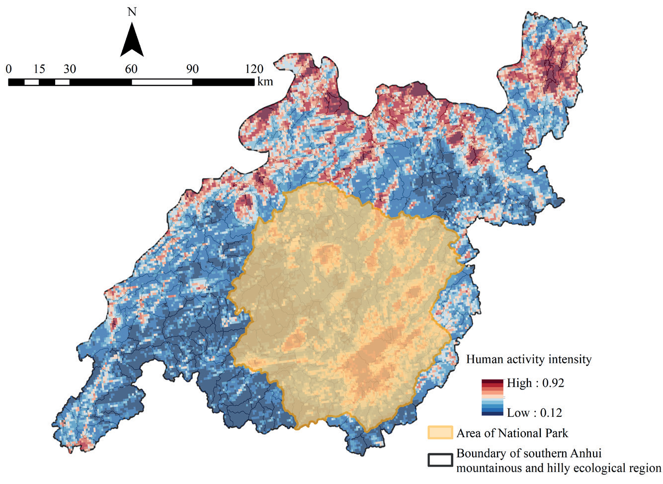
According to the correlation between the protection ratio and the average protection advantage, we found that the average protection advantage reached its peak when the ratio is at 37%. And since the minimum value of irreplaceability under this ratio is 2425, our study delineates the watershed unit with an irreplaceability value greater than 2425 as the boundary area of Huangshan National Park construction area (Fig. 7).
The scope of the delineated Huangshan National Park construction area is located in the Southern Anhui Mountainous and Hilly Ecological Region, consisting of 130 watershed units with an area of 9498.41 km2, accounting for 34.28% of the area in the eco-region. The boundary covers the most densely forested ecosystem of the national park with 82.48% of woodland and 1.08% of water, which owns superior natural resources. Next, 14.30% of the land is cultivated and 2.10% of the impervious surface, and the intensity of human activities is low in the study area, while high values of human activities are scattered in the national park, with the most intensive distribution in the southeast. Shrublands, grasslands, and barrens accounted for a relatively small percentage of 0.04%. In addition, according to the statistics, the delineated Huangshan National Park construction area protected 48.45% of the conservation features in the study area, among which 48.02%, 44.57%, and 35.44% of species richness, ecosystem services, and landscape diversity are protected respectively, while the conservation cost accounted for 35.81% of the study area, with good overall conservation effect.
Discussion
Discussion of National Park Areas
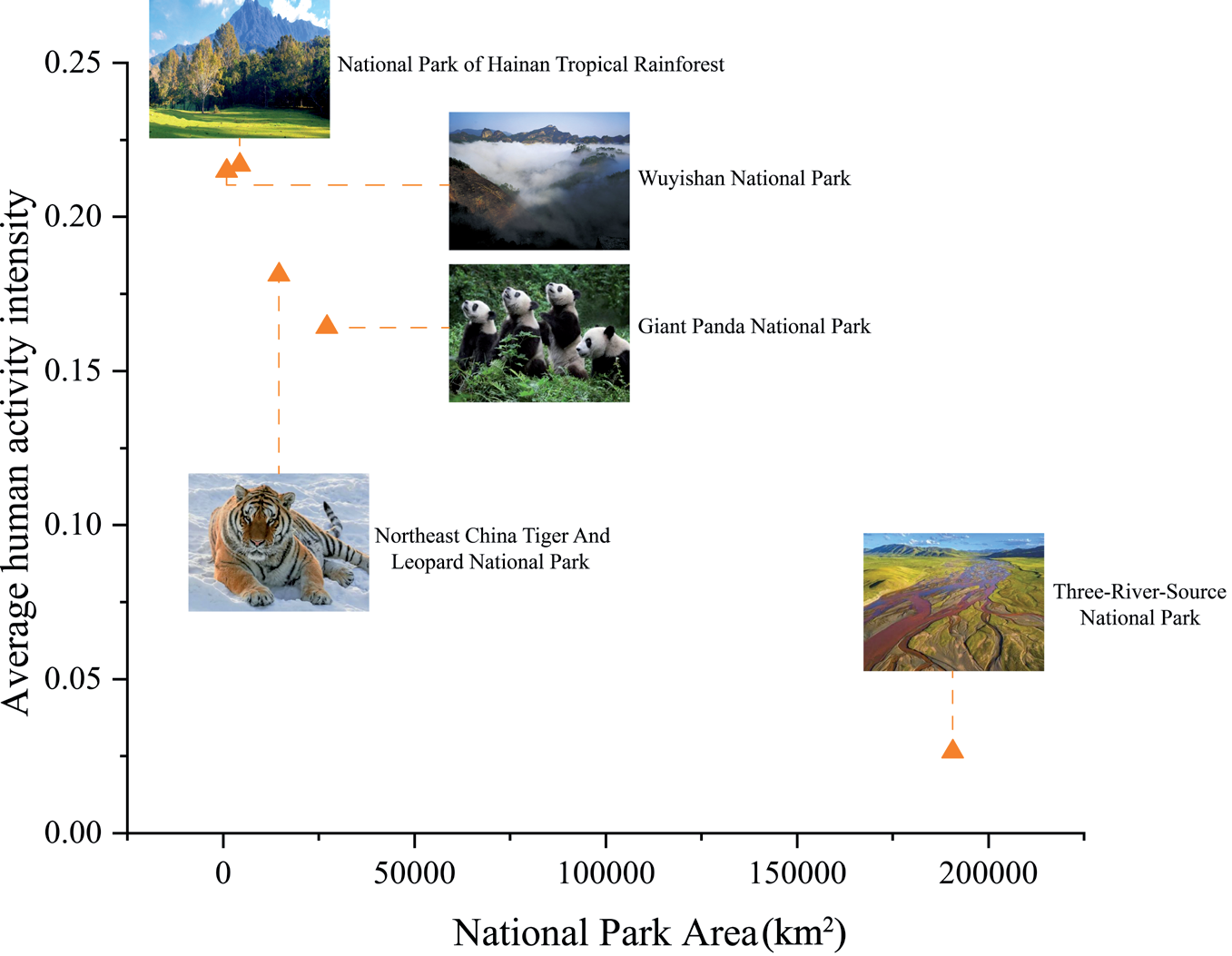
The delineation of national park areas often receives little attention. For instance, Three-River-Source National Park, one of the first national parks in China, has the largest area (190,700 km2) than Wuyishan National Park, which has the smallest area of 1001 km2. The size of the area is a key consideration in national park planning for future development [50]. The larger the area of a national park, the more adequate the protection of ecological integrity within the park. However, the size of a national park is limited by the size of the country, economic development, and other factors, while national parks with small areas may deviate from the requirements of “national representation” and “ecological process integrity”. Therefore, it is a very important task to set the threshold value of the national park area reasonably.
The study calculates the area of the first five national parks in China and the average human activity intensity (Fig. 8), and distinguish a significant negative correlation between the two. For example, Wuyishan National Park and Hainan Tropical Rainforest National Park have smaller areas, both of which have higher human activity intensity. While Three-River-Source National Park, which is less populated, has a larger national park area. In addition, the average human activity intensity in the Southern Anhui Mountainous and Hilly Ecological Region is 0.3719, which is high compared with the first national parks in China, and the boundary delineation of Huangshan National Park is bound to face serious human-land conflict. Therefore, this study uses conservation features and conservation costs to calculate the irreplaceability value and protection advantages of each watershed unit. And by analyzing their correlation, the number of watershed units in the scope of the national park is finally determined, taking into account both the integrity of conservation features and the cost of national park construction, which is conducive to the future sustainable development of the national park.
Considerations on the Huangshan National Park Construction Area
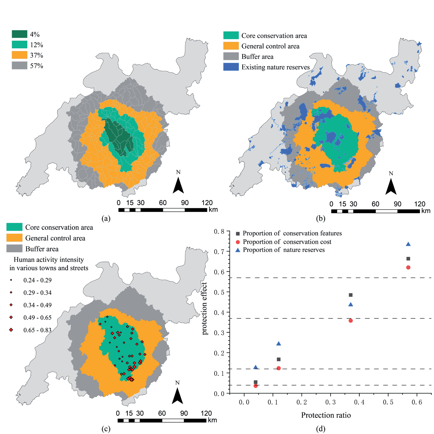
The correlation between the protection ratio and the average protection advantage (Fig. 6c) shows that the advantage has four obvious peaks at 4%, 12%, 37%, and 57% of the protection ratio, indicating a better conservation effect at this ratio. The distribution of the canonical cells of the four better protection ratios is shown in Fig. 9 a), with a clear aggregation trend. Based on this, our study develops the consideration of functional zoning of national parks. The zoning of national parks is an important mechanism for implementing differentiated management and achieving multifunctional goals, which involves the realization of conservation objectives. The early functional zoning of national parks in China was usually based on the characteristics of protected resources in the four-zone zoning method [51, 52] and the three-zone zoning method [53], but a unified set of standards and methods for functional zoning within national parks was not formed. However, with the announcement of Guidance on Establishing a Protected Area System with National Parks as the Mainstay, China’s nature reserves and national parks began to implement the two-zone zoning method of the core conservation area and general control area [54]. The functional zoning in this section is based on the two-zone zoning method.
Our study sets three indicators to evaluate the protection effect, which are the proportion of conservation features, the percentage of conservation costs, and the percentage of existing protected areas. Setting the protection ratio as the qualified line, the conservation effect is excellent when the ratio of conservation features and existing protected areas is above the pass line and the ratio of conservation costs is below the line. In general, the ratio of conservation features to existing protected areas under different protection ratios is higher than the qualified line, but there are cases when the ratio of conservation costs is lower than the qualified line (Fig. 9d). At 4%, the proportion of conservation features is above the qualified line, the proportion of existing protected areas is at a high level, and the proportion of conservation costs is also below the reference line. At 12%, the proportion of conservation features and existing protected areas are both at a high level, but the proportion of conservation costs is slightly higher than the qualified line, which is because the natural background resources of the area are better and attract many tourists, and we have to strictly protect the area and reduce the human activities in it. Therefore, The study classifies the area with 0~12% protection ratio as core conservation area (Fig. 9b). When the protection ratio is at 37%, both the protection feature and existing protected areas are at a high level, and the protection cost proportion is also lower than the qualified line, so The study classifies the area with 12%~37% protection proportion as the general control area (Fig. 9b). At 57%, the proportion of conservation features and existing protected areas are both at a high level, especially covering a large number of existing protected areas in the study area, but the cost of national park construction increases sharply due to the over-designated area. In cases such as Nepal and West Africa, some residents disagree with the legal requirements of national parks, because they are denied access to essential natural resources such as forest and water, and because of the almost inevitable harm to wildlife when they share the same landscape with humans, so buffer areas are often placed around national parks [55, 56]. To maintain ecological integrity and ensure participatory conservation by residents, buffer zones are often established around the periphery of national parks, and we, therefore, classify areas with 37% to 57% conservation ratio as buffer zones (Fig. 9b).
To better protect biodiversity, the core conservation area of Huangshan National Park should be protected by the principles of no reduction in area and intensity, and no change in protection characteristics. By superimposing the average intensity of human activities in the core conservation area and the towns and streets within it (Fig. 9c), The study found that the intensity of human activities in some of the townships in the core protected area is still at a high level, which may bring problems to the long-term management of Huangshan National Park. In response to this problem, the Guidance on Establishing a Protected Area System with National Parks as the Mainstay also proposes to adjust established cities and towns or densely populated areas with low conservation value and community livelihood facilities out of the scope of national parks [54]. Regarding this opinion, The study uses the natural breakpoint method to classify the towns and streets within the core conservation area into five categories, based on the average human activity intensity value, along with two suggestions followed. (1) Temporarily, the main urban construction areas of the three types of towns and streets with lower average human activity intensity values will be adjusted out of the scope of the core conservation area. However, this way of transferring out has both advantages and disadvantages, on the one hand, it can alleviate the serious human-land conflict relationship within the core protection area and avoid the one-size-fits-all style of management to bring inconvenience to the life and production of the residents, while on the other hand, the ecological integrity of the national parks has been greatly compromised. (2) Although the transferred towns and streets are no longer part of the national park in terms of laws and regulations, the physical space does not change, and if the problems of water pollution, soil erosion, environmental noise, and night lighting within them are more serious, they will still harm regional environmental protection. Therefore, Our study not only suggests transferring the main urban construction areas of the two types of towns and streets with higher average human activity intensity values out of the core area, but also should directly move the industries within them out of the national scope on a large scale to control the low level of human activity intensity. It should be noted that “transferring out” should only be a temporary measure for the establishment of the national park, which is not conducive to the long-term development of the national park, and more scientific and appropriate management methods need to be found in the future.
In addition, the government needs to establish an assessment mechanism for the core conservation areas that considers the integrity of the ecosystem and the development needs of society, as well as clarify the protection objects within the national parks. It should be exhaustive to specific natural areas such as forests, water, wetlands, and species habitats, and should also include human landscapes such as historical and cultural relics. The core conservation area is also rich in tourist attractions, one of which is the Huangshan Scenic Area. As a result, strict protection should still be implemented for this area in general, but given that the Huangshan Scenic Area has high recreational value in terms of local conditions, tourists should not be directly prohibited from entering. The government should restrict the flow of tourists in the scenic area and reduce the tourism-supporting facilities inside the core conservation area, such as moving the station, hotel, and toll gate out of the core area, to realize the separation of tourism, transport, and residence.
The general control area needs to be protected in a way that does not affect the well-being of the residents as much as possible, so human activities that have less impact on the environment should be allowed to exist. While heavy industries such as factories and mines that pollute heavily should be moved out of the national park area. In addition, it is necessary to establish a system of participation by the indigenous people and communities, so that it can be established, monitored, and shared by all. The government first needs to clarify the boundaries of residential and agricultural areas in this area to avoid the uncontrolled expansion of construction land and arable land. They also should focus on the management of domestic waste and wastewater, and avoid the random discharge of agricultural waste, such as chemical fertilizers and pesticides to prevent the bad impact on the ecological environment. In addition, under the guideline of not affecting the environment, residential and recreational activities can be properly developed in this area. For instance, this area is more suitable for establishing a national park town with characteristics rich in Huizhou culture, which can meet the demand for science and education for tourists and also provide jobs for residents and facilitate government management. Moreover, the centralization of recreational activities can minimize the impact on the natural environment.
Fig .9.
Distribution of watershed units with different protection ratios a), Huangshan National Park zoning b), average intensity of human activities in towns and streets in the core conservation area c), and correlation between protection ratios and protection effects d).
Buffer areas serve as transitional areas within and outside national park boundaries, and their primary responsibility is to provide ecological buffers and compensation for community benefits in national parks, which are important tools for national park conservation management [55, 57]. It has been found that the construction of protected areas can be a double-edged sword [58], leading to the increasing isolation of protected areas, but that protected areas cannot control human activities outside of them, and that there can be more intense retaliatory urbanization in their vicinity. Based on this objective phenomenon, this study proposes to designate a buffer area outside the boundary of Huangshan National Park. The buffer zone should be controlled mainly in three aspects: construction control, industrial control, and behavior control, reasonably controlling the expansion of construction land within the buffer zone, strictly limiting industrial energy consumption, and guiding human activities in the area to achieve a measured and controlled development. In addition, the government should monitor the ecological environment, and if ecological damage is found, relevant production and living activities should be stopped immediately and ecological restoration should be started.
Shortcomings and Prospects
This study explores the boundary of the Huangshan National Park construction area by taking the Southern Anhui Mountainous and Hilly Ecological Region as an example, analyzes the species richness, typical ecosystem services, and landscape diversity values in the study area, and delineates the boundary of the Huangshan National Park construction area by using the protection advantage and irreplaceability values, and the results of the study can be a reference for the future construction of the Huangshan National Park. However, due to the availability of data, this study still has the following three shortcomings, which we hope to improve in future studies.
(1) In this research, considering the integrity of the ecosystem within the national park, the Southern Anhui Mountainous and Hilly Ecological Region is selected as the site selection range for the creation of Huangshan National Park, according to the ecological function zoning of Anhui Province. However, by analyzing the results of species richness, ecosystem services, and biodiversity, it can be found that the high-value areas are almost all distributed in the southern boundary of the eco-region, therefore, resource surveys should be conducted on a larger scale in subsequent studies to increase the scope of site selection. (2) The Marxan model can handle data of multiple species at the same time. In this paper, only species diversity data of mammals and birds are selected for input, and species data from field monitoring can be applied in the follow-up study to protect specific species. In addition, The study selects human activity intensity as cost data in determining national park boundaries, because the expected maximum acceptable construction cost is difficult to determine, so the Cost Threshold Penalty indicator in the Marxan model is not considered. But in the realistic national park establishment process, the Cost Threshold Penalty indicator needs to be taken into account, which can effectively control the cost budget.
(3) The boundary itself is dynamic in nature, and the dynamic development trend of future national park boundaries can be simulated by quantified means in the future, such as multi-scenario simulation of land use data of Huangshan National Park, to cope with multiple conservation needs in the future.
Conclusion
The biodiversity and ecological value of the Southern Anhui Mountainous and Hilly Ecological Region have an important status regionally, nationally, and even globally. The establishment of Huangshan National Park within this scope must include the precious resources and landscapes within it. Therefore, this study starts from the basic objectives of national park protection, combines the actual situation of resource endowment, the current situation of protection and management, and the distribution of conflicts in the Huangshan National Park construction area, and obtains the boundary delimitation solution of the construction area, under the premise of protection and taking into account the community development needs. The main conclusions of this study are as follows: (1) The distribution of species richness, ecosystem services, and landscape diversity results in the Southern Anhui Mountainous and Hilly Ecological Region differ slightly, but the juxtaposition of high-value areas is mainly gathered in the southern part of the study area, which is mainly woodland, less affected by human activities, and has better originality and integrity of the ecosystem. (2) This paper finally completes the boundary delineation of the Huangshan National Park construction area by analyzing the boundary benefits of protection advantages under different protection ratios. It is found that the average protection advantage of the planning unit is the highest when the protection ratio is 37%, therefore, the irreplaceability value is greater than 2425, and this is delineated as the boundary. The boundary of the Huangshan National Park Creation Area is mainly located in the central and southern parts of the study area, which contains 130 watershed units with a total area of about 9498.41 km2.

