

Introduction
Coalfield mining can cause a series of mine environmental problems, such as large-scale air-mining areas, leakage of surface water, the deterioration of groundwater quality, etc., which seriously threaten the water safety of residents’ living, production and industry [1-4]. The rational development and utilization of water resources, especially groundwater resources, are significant to the ecological environment protection and the sustainable development of the coalfield [5-7].
The chemical compositions of groundwater are the main elements of the hydrogeological study in the mining area, which is intimately linked with regional geochemical evolution and cycling processes. Investigating its spatial distribution is essential for delineating hydrogeochemical processes and flow paths in mines. Currently, a suite of established methodologies, including ion ratios, multivariate statistical analysis, isotopic tracing, hydrochemical modeling, geographic information systems (GIS), hierarchical clustering analysis (HCA), principal component analysis (PCA), and self-organizing maps (SOM), are extensively utilized to investigate the dominant factors and spatiotemporal variations of hydrochemical evolution within the multilayered aquifer systems [8-19]. Moreover, water-stable isotopes and tritium radioactive isotopes have been extensively employed to investigate the origin and age of the water [20-24].
The Huaibei coalfield, an important coal production zone in Eastern China, is underlain by a groundwater system composed of multiple aquifers, and these aquifers have proved that there is a certain hydraulic connectivity between different aquifers. Currently, with the development of deep mining, the original underground flow patterns have been gradually changed. This may enhance the hydraulic connections among the aquifers, thereby elevating the risk of water inrush events. Particularly, the Taiyuan Formation limestone in the Huaibei coalfield, being a deep and abundant aquifer, presents a significant threat to deep mining operations [25, 26].
In response to the hydrogeochemical evolution in the Huaibei coalfield, numerous researchers have conducted a series of hydrogeochemical studies, which focus on both single and multiple aquifer systems [27- 30]. For instance, Zhang et al. (2022) used cluster analysis combined with geological conditions, water-rock interactions and mining activities to investigate the spatiotemporal variations and primary controlling factors of deep groundwater hydrogeochemistry in the Carboniferous limestone aquifer of the Huaibei coalfield [31]. Meanwhile, Cheng et al. (2022) combined hydrochemical and dual isotopic analyses of sulfate in surface water, soil water and groundwater with evaluations of the UZ to identify the groundwater sulfate source and transformation in the coal mining area [32]. Although previous studies have made certain progress in the field of hydrogeochemistry of groundwater in mining areas, regional research on the hydrochemical evolution of Taiyuan Formation limestone groundwater, particularly from the perspective of deep water-bearing system and flow system, combined with the specific characteristics of the hydrological circulation conditions of deep groundwater in mining areas, is still relatively lacking. Systematic analyses along flow paths are especially scarce. In addition, previous studies have mostly focused on qualitative analysis of hydrochemical reactions, and there is a shortage of quantitative simulation research on the hydrochemical evolution of Taiyuan Formation limestone groundwater. In fact, unlike the conditions of shallow unconsolidated groundwater circulation, deep groundwater circulation in the Taiyuan Formation is often significantly affected by regional faults and major fractures [33, 34], which is often ignored by previous studies [35, 36]. Therefore, accurately understanding the distribution of water-blocking faults in Sunan mining area and defining hydrological units, as well as conducting reverse simulation modeling, will contribute to the elaborate characterization of hydrogeochemical evolution.
Therefore, in order to master the intrinsic geochemical evolution of the Taiyuan Formation limestone groundwater in Sunan mining area of Huaibei coalfield, the Piper diagram, the Gibbs diagram, the ion ratio relationship, and the Chlorine-Alkali index are utilized. Furthermore, the reverse hydrogeochemical modeling was employed using PHREEQC software. The main objectives of this study are: 1) analyze the hydrochemical characteristics and explore the mechanism of deep water-rock interactions, 2) verify the water-rock interactions quantitatively. This provides a more systematic perspective for the study of groundwater hydrogeochemistry, and is a step forward in the knowledge of quantitative simulation of regional deep confined aquifer systems. The findings of this study would provide a scientific basis for water hazard prevention and rationalization of deep groundwater resources.
Material and Methods
Regional Geological Situation
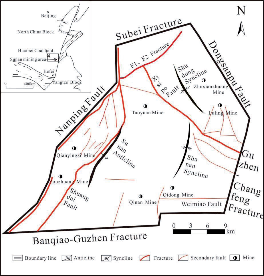
Huaibei coalfield is an important coal production base in China, crossing three cities and seven counties in northern Anhui Province. The coalfield covers an area of 30,000 km2, with proven reserves of 6.7 billion tons. Sunan mining area is located in the southeast of the coalfield, inside the Suxian-Guoyang depression zone. The terrain in the mining area is relatively flat, with an elevation of 20.6 to 27.3 m. The surface rivers in the mining area belong to the Huai River system, mainly including Tuo River, Xinbian River, Hui River and other seasonal rivers. The Taiyuan Formation is about 600 m deep and 105~160 m thick with an average of 130 m, the formation lithology is mainly dark gray to gray limestone, which accounts for 40% of the formation thickness, with sandstone, siltstone, mudstone and carbonaceous mudstone. The recharge of groundwater runoff is poor due to the fact that the groundwater of Taiyuan Formation limestone consists mainly of buried and confined karst groundwater, and its water richness varies greatly, from weak to very strong, specifically strong in the east and north, and weak in the south and west. Vertically, the watery is strong in the upper part and weak in the lower part. Because of its proximity to the main mineable coal seam (No. 10 coal), the groundwater of Taiyuan Formation limestone is the main aquifer which threatens mining safety.
Table 1.
Development characteristics of fold structure in Sunan mining area.
Table 2.
Characteristics of main faults in Sunan mining area, Huaibei coalfield.
Sunan mining area belongs to the southeast of North China plate tectonically, the structures of Sunan mining area are controlled by the superposition of Indosinian movement and Yanshan movement. The NNE structures, NW structures and near EW structures are mainly developed [37] (Tables 1, 2). With the EW extension in the late Indosinian period, regional boundary faults were formed, and in the middle and late Yanshan movement, the major fractures were formed. The low-order NW structures and NE-NNE structures were distributed in the fault blocks formed by regional faults and major fractures [38] (Fig. 1).
Data Collection and Processing
In this paper, the conventional hydrochemical data of limestone water of typical Taiyuan Formation in Zhu Xian Zhuang coalmine, Luling coalmine, Taoyuan coalmine, Qinan coalmine, Qidong coalmine, Zouzhuang coalmine, and the Qianyingzi coalmine in Sunan mining area were collected [28, 39, 40].The data included seven conventional ion components K+ + Na+ (replaced by Na+ due to the low content of K+ and its similar chemical properties to Na+), Ca2+, Mg2+, Cl-, SO42-, HCO3-, and CO32-. The values of TDS and pH were also applied to suggest these hydrochemical characteristics.
Considering the existence of subjective and objective errors in the test process, the data were tested for anion and cation balance, and the test formula was calculated as follows:
Where E is the relative error, mc and ma are the milligram equivalent concentration (meq/L) of anions and cations, respectively. If K+ and Na+ are measured values, E values should be less than 5% positive and negative. If K+ and Na+ are calculated values, E values should be zero or close to zero. The tests revealed that the E-values of the groundwater samples from the Taiyuan Formation at the mine site were in a reasonable range (-2.66% to 1.81%), and the results could be used for subsequent analyses
Research Methods
Hydrological Units Division
Tectonic water control is closely related to the mechanical nature of the tectonics, tectonic morphology, generation and resurrection time, the fracture zones of regional faults and major fractures are densely cemented and tend to form water-resisting boundaries [41]. According to the structures, stratigraphic conditions, hydrogeological characteristics and boundary conditions, the hydrological unit of Huaibei coalfield can be divided into two primary hydrological units in the north and south; the southern hydrological unit is divided into three secondary hydrological units, viz. Sunan, Linhuan and Guoyang. Due to the distribution of water-blocking faults (mainly concave-controlling faults and basin-controlling faults), the tertiary hydrological unit in Sunan mining area was further divided on the basis of the division of the primary and secondary hydrological units.
Reverse Simulation
Based on chemical thermodynamics and chemical kinetics, hydrogeochemical modeling has been studied since the 1960s, and WATEQ, WATEQF, EQ3/6, SOLMINEQ.88, PHREEQC, NETPATH, MT3DMS, NETPATH, PHAST and other software have been developed with the wide application of computer [42]. The PHREEQC software based on ion-association water model is the most widely used simulation program [43, 44], which can realize the simulation calculation of mineral saturation index and mass transfer of mineral or gas components in the process of groundwater runoff under different paths. The saturation index (SI) of major minerals, which represents the saturation state of minerals relative to groundwater, is a necessary parameter for reverse geochemical modeling. When the value of SI is greater than 0, it indicates that the mineral is in a saturated - oversaturated state, and the mineral tends to precipitate. When the value of SI is less than 0, it indicates that the mineral is in an unsaturated state, and the mineral tends to dissolve.
Results and Discussion
Hydrochemical Characteristics
Characteristics of Hydrochemical Components
In terms of ion concentration, the cations of groundwater samples in the mining area were mainly K++Na+ and Ca2+, and the anions were mainly SO42-, HCO3- and Cl-. The concentration of K++Na+ ranged from 27.3 to 413.73 mg/L, with an average of 168.8 mg/L, and the concentration of K++Na+ of water sample No. 11 was the highest. The concentration of Ca2+ ranged from 4.45 to 385 mg/L, with an average of 161.5 mg/L. The concentration of SO42- ranged from 2.47 to 1180 mg/L, with an average of 481.5 mg/L, the highest concentration of SO42- was found in water sample No. 7. The concentration of HCO3- ranged from 33.9 to 529.1 mg/L, with an average of 38.3 mg/L, of which the highest concentration of HCO3- was found in water sample No. 2. The concentration of Cl- ranged from 13.95 to 339 mg/L, with an average of 175.5 mg/L (Table 3).
Table 3.
Characteristics of main faults in Sunan mining area, Huaibei coalfield.
In terms of TDS and pH, the concentration of TDS ranged from 123 to 2190 mg/L, with an average of 1043.5 mg/L. The pH value ranged from 7.7 to 10.1, indicating that the groundwater was weakly alkaline to alkaline. The pH value of water sample No. 16 from Zouzhuang coalmine was the highest, and the TDS concentration of water sample No. 6 from Taoyuan coalmine was the highest with 2190 mg/L (Table 3).
Hydrochemical Type Analysis
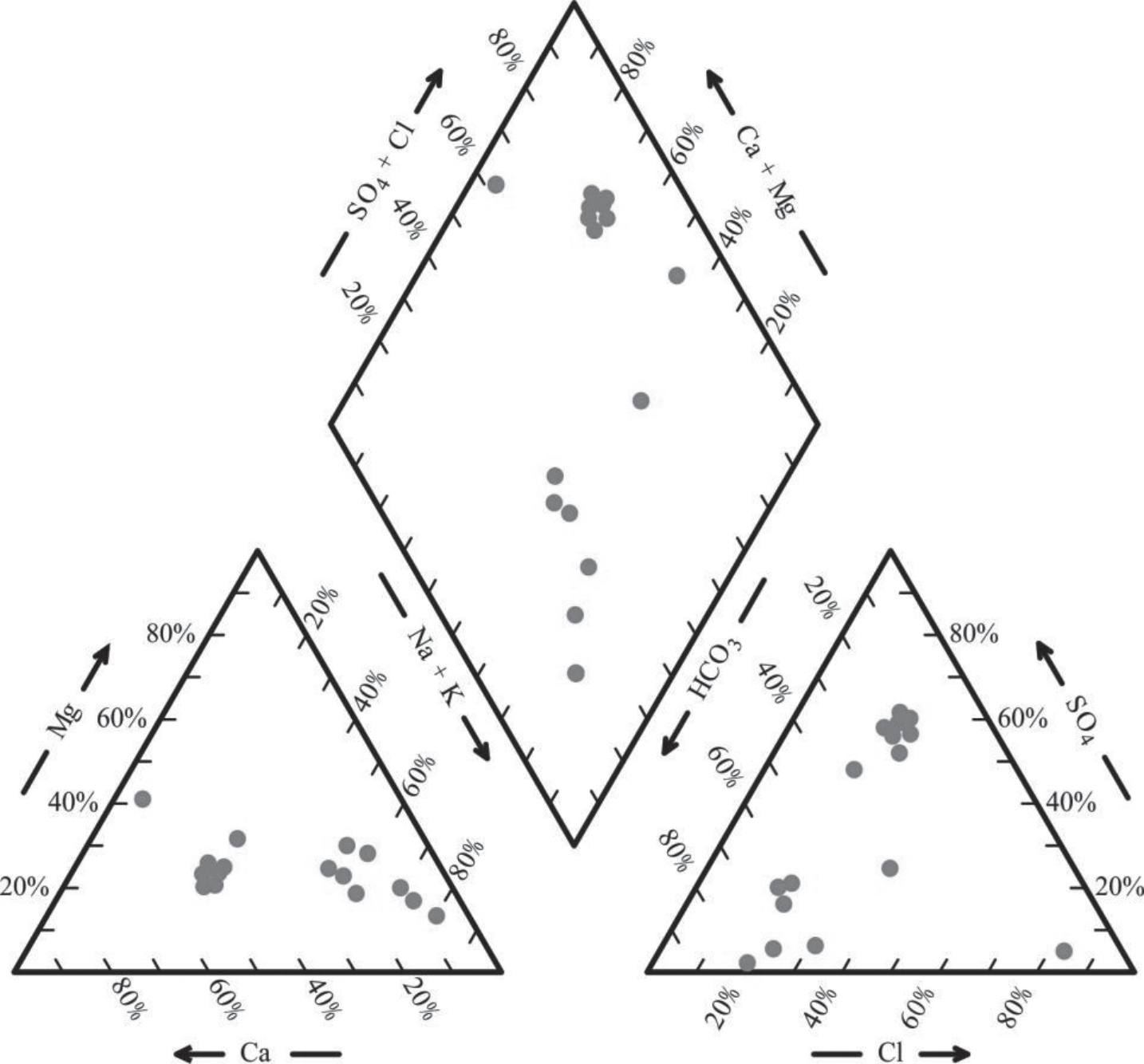
According to the Piper three-line diagram of Taiyuan Formation limestone water in Sunan mining area of Huaibei coalfield (Fig. 2), the hydrochemical types of Taiyuan Formation limestone water in the mining area were mainly SO4.Cl-Ca.Mg (50%) and HCO3.Cl -Na (43.75%). There are obvious differences in the hydrochemical types between different regions of the mining area, the HCO3.Cl-Na type was dominated in the western and eastern parts of the Sunan mining area, and the SO4.Cl-Ca.Mg type was dominated in the central part of the mining area.
Hydrochemical Formation Mechanism
Gibbs Diagram
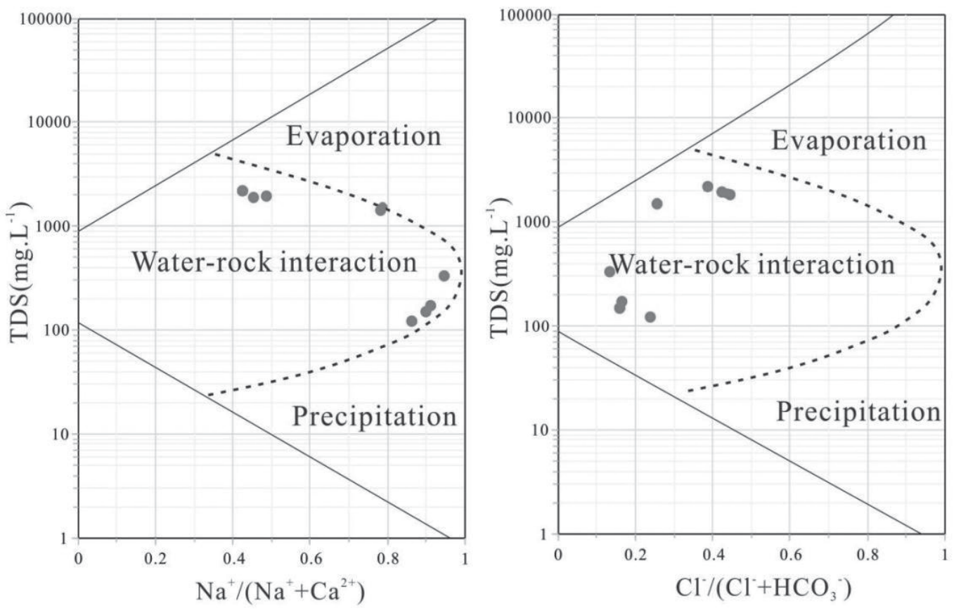
The Gibbs diagram can macroscopically reflect the controlling factors of major ions in the process of groundwater formation. Generally speaking, the control factors of major ions are divided into three types: evaporation concentration-controlled, rock weathering-controlled and precipitation-controlled. As shown in Fig. 3, the water sample points of Taiyuan Formation limestone were mainly located in the water-rock action zone, far away from the evaporation zone and atmospheric precipitation zone, indicating that the water-rock action played a dominant role in the chemical composition of groundwater.
Dissolution
The difference of chemical composition of groundwater is affected by many factors, such as dissolution and precipitation of halite, carbonate minerals, sulfate minerals, weathering of silicate minerals and ion exchange, of which the strength of lixiviation depends on the solubility of rock, the development of pores, the solubility of water, and the alternating strength of water [45]. The ion ratio relationship can be used to reveal the source of chemical components in groundwater and the possible hydrogeochemical effects.
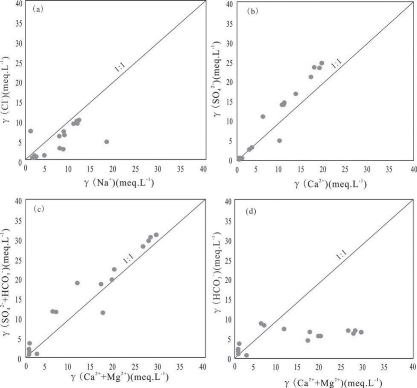
Based on the relative stability of Cl- in groundwater [46], the relationship between Na+ and Cl- can be used to explore the source of Na+ in groundwater. The Na+-Cl- molar ratio produced by halite dissolution was 1:1. From the Fig. 4a), it can be seen that the water samples of the Taiyuan Formation limestone aquifer were generally below the 1:1 dissolution line of Na-Cl. The relatively high Na+ was derived from the dissolution of rock salt, and it can also be derived from the alternating adsorption of Mg2+ and Ca2+ in the water layer and Na+ ions in the surrounding rock, resulting in the increase of Na+ in the water layer.
The relationship between Ca2+ and SO42- in groundwater can be used to explore the source of SO42- in groundwater. The ion ratio of Ca2+ - SO42- generated by gypsum dissolution was 1:1. As can be seen from the Fig. 4b), the water samples were generally close to the 1:1 dissolution line, indicating that the main source of SO42- was the dissolution of gypsum. The water samples located above the 1:1 dissolution line may be owing to the increase of HCO3- caused by desulfurization, which furthermore resulted in calcite precipitation (Eq. 2, 3) and the decrease of Ca2+.
The relationship between (Ca2+ + Mg2+) and (HCO3- + SO42-) in groundwater reflected the main source of Ca2+ and Mg2+ [47]. The ratio of (Ca2+ + Mg2+) – (HCO3- + SO42-) produced by the dissolution of carbonate and sulfate was 1:1. As shown in Fig. 4c), all water samples were generally distributed along the dissolution line 1:1 of (Ca2++Mg2+) - (HCO3-+SO42-), indicating that the dissolution of gypsum, calcite and dolomite was the main source of Ca2+ + Mg2+ ions in groundwater. Most of the water samples located above the 1:1 dissolution line implied that there are other losses of Ca2+ and Mg2+. It is highly probable that Mg2+ and Ca2+ in the limestone groundwater were alternately adsorbed with Na+ in the surrounding rocks.
The relationship between (Ca2+ + Mg2+) and HCO3- in groundwater can also be used to confirm the main source of Ca2+ and Mg2+. The (Ca2+ + Mg2+) – HCO3- ion ratio produced by carbonate dissolution was 1:1. As shown in Fig. 4d), the contents of (Ca2+ + Mg2+) were much higher than HCO3- in some water samples, which proclaimed that carbonate dissolution was one source of Ca2+ and Mg2+, and other sources may be from the sulfate dissolution.
Ion Exchange Adsorption
The Chlorine-Alkali Index (CAI) was commonly used to describe the direction and intensity of cation exchange [48]. When the values of CAI-1 and CAI- 2 were negative, it indicated that the Ca2+ and/or Mg2+ in the groundwater were exchanging ions with Na+ and/or K+ in the surrounding rock. When the values of CAI-1 and CAI-2 were positive, it demonstrated the existence of reverse ion exchange. When the absolute values of CAI-1 and CAI-2 were larger, it suggested that the strength of ion exchange was stronger, and a value of 0 indicated that there was no ion exchange during the hydrochemical evolution..
The formulas for CAI-1 and CAI-2 were as follows:
Table 4.
Concentrations of mineralization degree of Taiyuan Formation limestone groundwater (mg / L).
| Mineralization degree | SuⅡ-1 | SuⅡ-2 | SuⅡ-.3 | Sunan |
|---|---|---|---|---|
| Maximum value | 1929.11 | 2685 | 387.88 | 2685 |
| Minimum value | 132.99 | 211.58 | 178.65 | 132.99 |
| Average value | 892.7 | 1808.7 | 283.265 | 1376.82 |
Fig. 5.
Chlor-alkali index and (Ca2+ + Mg2+ – HCO3– – SO4 2–)/(Na+ + K+ – Cl–) of limestone groundwater.
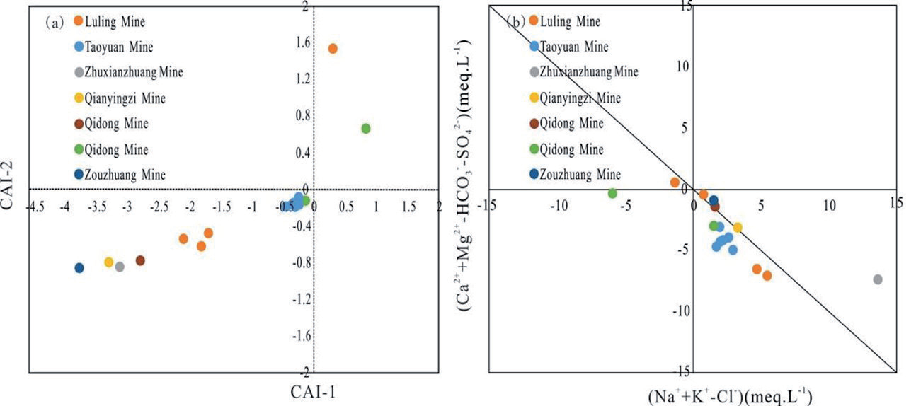
The unit of each index was meq/L.
According to the Chlorine-Alkali Index diagram of limestone groundwater in the mining area (Fig. 5a), the CAI-1 and CAI-2 values of limestone water in Taiyuan Formation ranged from -3.76 to 0.83 and -0.86 to 1.53, respectively. The values of all water samples were less than 0, except for water sample No. 3 from Luling Mine and water sample No. 15 from Qinan Mine, suggesting that the limestone water in the Taiyuan formation mainly underwent positive cation exchange (Eq. 6), resulting in Ca2+ and Mg2+ in the groundwater replacing Na+ in the surrounding rock.
In addition, (Ca2+ + Mg2+ – HCO3- – SO42-)/(Na+ + K+ – Cl-) can be used to analyze the influence of ion exchange on water. Specifically, (Na+ + K+ – Cl-) represented the increase or decrease of Na+ + K+ except for the dissolution of halite, and the (Ca2+ + Mg2+ – HCO3- – SO42-) represented the increase or decrease of Ca2+ + Mg2+except for the dissolution of calcite, dolomite and gypsum. From Fig 5b), it can be seen that the water samples in the study area were mainly distributed in the IV quadrant of the coordinate axis, and most of the water samples fell on or closed to the - 1:1 straight line, indicating that the limestone water of Taiyuan Formation was affected by ion exchange, which was in agreement with the conclusion of the Chlorine-Alkali Index (CAI). The farther the water sample point was from the coordinate origin, the stronger the ion exchange effect was. So, it can be inferred that the ion exchange effect was stronger in the mines of Zhu Xianzhuang, Luling, Qinan and Taoyuan than in the mines of Zouzhuang, Qidong and Qianyingzi.
Hydrogeochemical Reverse Simulation
Tertiary Hydrological Units Division
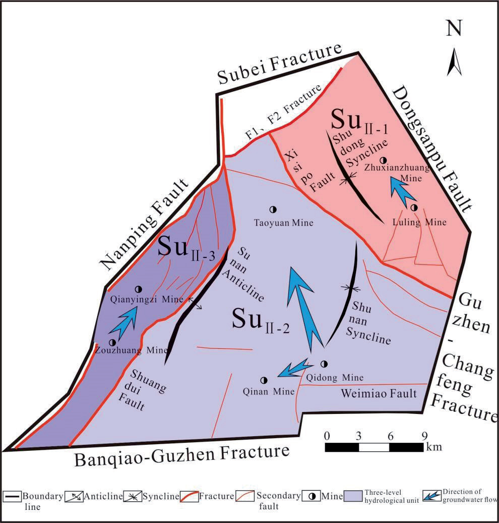
Taking the Xisipo reverse fault and the Shuangdui normal fault as the dividing line, which have a drop of more than 1,000 meters and are the relative watertight boundaries of the mine area, the Sunan mining area, which is a secondary hydrological unit, was divided into three tertiary hydrological geological units: SuII-1, SuII-2 and SuII-3.
The Xisipo thrust fault is located in the northeastern part of the mining area and belongs to the Xusu nappe shielding fault, which thrusts the Ordovician Cambrian limestone in the upper plate onto the Carboniferous Permian limestone in the lower plate, resulting in the interruption of the hydraulic connection between the two plates.
Table 5.
Water level elevation of tertiary hydrological unit in Sunan mining area (m).
| Water level elevation | SⅡ-1 | SⅡ-2 | SⅡ-3 | ||||
|---|---|---|---|---|---|---|---|
| Luling mine | Zhuxianzhuang mine | Qidong mine | Qinan mine | Taoyuan mine | Qianyingzi mine | Zouzhuang mine | |
| 9.44~20.98 | - | 8.09~19.6 | –93.9~–10.1 | –173.4~–69 | 18.6~50.19 | - | |
Fig. 6.
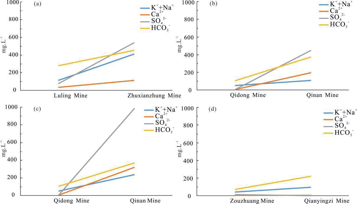
The variation of main ion concentration in different runoff paths of Taiyuan Formation limestone groundwater in Sunan mining area.
The Shuangdui normal fault extends to the northeast and cuts the western flank of the Sunan anticline. The Carboniferous-Permian strata on the lower plate of the fault buttress the Ordovician-Cambrian strata on the upper plate, resulting in the interruption of the hydraulic connection of the limestone water in the Taiyuan Formation on both sides, and the Taiyuan Formation limestone water in the upper side is recharged by the Ordovician limestone water in the lower side.
The limestone aquifers of Taiyuan Formation were relatively closed among different hydrological units with very small mutual connectivity and large differences in mineralization degree and water level elevation. The mineralization degree of Taiyuan Formation limestone groundwater in the mining area ranges from 132.99 to 2685 mg/L, with the maximum value occurring in the Taoyuan mine of the SuII-2 hydrological unit, and the minimum value occurring in Luling mine of SuII-1 hydrological unit (Table 4). The difference of mineralization degree reflects the strength of karst development and groundwater runoff between the three tertiary hydrological units to some extent. Specifically, the karst development and the groundwater runoff of SuII-2 hydrological unit is relatively strong, the karst development and the groundwater runoff of SuII-1 hydrological unit is relatively weak, and SuII-3 hydrological unit is the weakest.
In terms of the original water level elevation, the water level elevation of the Taiyuan formation limestone groundwater in the mining area varied greatly, showing high around and low in the middle, in which SuII-3 water level elevation>SuII-1 water level elevation>SuII-2 water level elevation, also showing obvious blocky characteristics (Table 5).
Selection of Simulation Path
The characteristics of limestone water runoff in Taiyuan Formation are mainly controlled by the tectonic background and dominated by horizontal movement, with no overflow movement between aquifers, which means that the selection of runoff paths must be based on rational and fine-grained division of hydrological units.
According to the regional hydrogeological conditions and the division of tertiary hydrogeological units, and with reference to the spatial distribution characteristics of dominant ions and TDS (along the direction of the runoff , with the increase of the runoff path, the concentration of dominant ions and TDS increases under the effect of leaching and ion exchange, as shown in Fig. 6, the concentrations of SO42- and HCO3- of the rest of the paths are significantly increased except for Zouzhuang mine → Qianyingzi mine), the simulation paths were selected. Each simulated water flow path included two water sample points: the initial water sample and the terminal water sample. Finally, four simulation paths were identified in the mining area, including Luling mine → Zhuxianzhuang mine, Qidong mine → Qinan mine, Qidong mine → Taoyuan mine, Zouzhuang mine → Qianyingzi mine, as shown in Fig. 7.
Determination of Possible Mineral Phase
The selection of possible mineral phases is fundamental and critical in determining the reactions that may occur along groundwater flow paths and is central to inverse hydrogeochemical modeling [49].
Firstly, based on the distribution characteristics of dominated ion such as K++Na+, Ca2+, HCO3-, SO42- in the Taiyuan Formation limestone groundwater in the Sunan mining area, and combining with the lithological characteristics and hydrogeochemical formation mechanism of the Taiyuan Formation, the calcite, dolomite, gypsum, and halite were selected as the main mineral phases. Secondly, considering the cation exchange adsorption, NaX, CaX2, and MgX2 were selected as the main mineral phases. Finally, CO2(g) was selected as a possible mineral phase considering that CO2(g) would continue to dissolve into groundwater, and H2S(g) ) was selected as a possible mineral phase considering desulfurization. The dissolution of albite would lead to the increase of Na+, which was selected as a possible mineral phase, and also FeS2 and O2(g) were considered as possible mineral phases considering the oxidation of pyrite due to mining disturbance
The SI values of main minerals in the limestone groundwater samples from the Taiyuan Formation in the mining area were simulated by reverse hydrogeochemical simulation (Table 6). The SI values of calcite and dolomite in all mines in the Sunan mining area were greater than 0, indicating that they were in a supersaturated state and were not the main source of Ca2+, Mg2+, HCO3-. The SI values of gypsum and halite were less than 0, indicating that they were always in a dissolved state in groundwater and the leaching of gypsum and halite was continuous during the water runoff in the Taiyuan Formation, which were an important source of Ca2+, Na+, Cl- and SO42- in groundwater. The SI values of albite and pyrite were both 0, with no precipitation or dissolution, which could be excluded as the possible phases.
Table 6.
SI values of main minerals of Taiyuan Formation limestone groundwater in Sunan mining area.
Table 7.
Simulation results of Taiyuan Formation limestone groundwater under different simulation paths (mmol / L).
Material Transfer under Different Runoff Paths
The complexity of the lithology, geology and the surrounding physical, chemical and biological environment of the aquifer leads to multiple solutions for the simulation results. It is necessary to determine the optimal solution based on the hydrogeological conditions of the study area, combined with the source analysis of hydrochemical components and the saturation index of minerals. When the amount of mineral transfer is greater than 0, it means that the minerals are dissolved (or gases dissolve into the groundwater), and the amount of mineral transfer is less than 0, it means that the minerals precipitate (or gases escape from the groundwater). The simulation results of hydrogeochemical reactions under different runoff paths (the uncertainty in the simulation process is 0.05) were shown in Table 7.
In runoff path 1 from Luling mine to Zhu Xian Zhuang mine, the hydrochemical type of Taiyuan Formation limestone groundwater changed from Na-HCO3 type to Ca-SO4 type, and the dissolution and leaching of gypsum, halite and dolomite mainly occurred, with the dissolution amounts of 4.83 mmol/L, 1.82 mmol/L and 1.7 mmol/L, which led to an increase in the content of Na+, Ca2+, Mg2+, SO42- and CL-, respectively. The increased content of Ca2+ in water resulted in the precipitation of calcite with the amount of 1.98 mmol/L. Positive cation exchange occurred with Ca2+ and Mg2+ in the groundwater replacing Na+ in the surrounding rock, and the exchange amount was 5.26 mmol/L. During the runoff process, CO2 gas was dissolved into the water body, causing dolomite (SI>0) to continue to dissolve and precipitate with a lag, the content of HCO3- to increase and PH to decrease.
In runoff path 2 from Qidong mine to Qinan mine, the hydrochemical type of Taiyuan Formation limestone groundwater changed from Na-HCO3 type to Ca-SO4.Cl type, and the dissolution and leaching of halite, gypsum and dolomite occurred, with the dissolution amounts of 6.49 mmol/L, 4.6 mmol/L and 3.92 mmol/L, which led to an increase in the content of Na+, Ca2+, Mg2+, Cl- and SO42, respectively. The increased content of Ca2+ in water resulted in the precipitation of calcite with the amount of 5.63 mmol/L. Reverse cation exchange occurred with Na+ in groundwater replacing Ca2+ and Mg2+ in the surrounding rock, and the exchange amount was 3.88 mmol/L, resulting in a decrease in the content of Na+. During the runoff process, a large amount of CO2 gas was dissolved into the groundwater, resulting in partial dissolution of the dolomite (SI>0), an increase in the content of HCO3- and a decrease in pH..
Because the runoff path 3 from Zouzhuang mine to Qianyingzi mine was shorter than other paths, the intensity of leaching and ion exchange was lower than other paths, and the hydrochemical type had not changed, which was still Na-HCO3 type. The dissolution and leaching of gypsum and halite mainly occurred, with the dissolution amounts of 1.12 mmol/L and 0.58 mmol/L. Positive cation exchange occurred with Ca2+ and Mg2+ in groundwater replacing Na+ in surrounding rock, and the exchange amount was 1.93 mmol/L. The dissolution of dolomite and the precipitation of calcite were relatively weak. During the runoff process, H2S gas escaped from the groundwater and desulfurization occurred.
In runoff path 4 from Qidong Mine to Taoyuan Mine, the hydrochemical type of Taiyuan Formation limestone water changed from Na-HCO3 type to Ca-SO4 type, and the dissolution and leaching of gypsum, halite and dolomite occurred, with the dissolution amounts of 10.23 mmol/L, 7.53 mmol/L and 3.97 mmol/L, which led to an increase in the content of Mg2+, Na+, SO42- and Cl-. The increased content of Ca2+ in water resulted in the precipitation of calcite with the amount of 5.76 mmol/L. Ca2+ and Mg2+ in groundwater replaced Na+ in surrounding rock with the exchange capacity was 1.11 mmol/L. During the runoff process, CO2 gas was dissolved into the water body, causing dolomite (SI > 0) to continue to dissolve, the content of HCO3- to increase and PH to decrease.
Overall, the dissolution and leaching of gypsum, halite and dolomite and the precipitation of calcite occurred in all simulated paths, showing approximately the same dissolution and precipitation pattern, with Path 4>Path 2>Path 1>Path 3 in terms of the intensity of action. Positive cation exchange occurred in all paths except path 2, with path 1>path 3>path 4 in terms of the intensity of action, where desulfurization occurred in path 3.
Conclusion
This study delves into the hydrochemical characteristics and formation mechanism of the Taiyuan Formation limestone groundwater by using Piper three-line diagram, Gibbs diagram, ion proportional relationship, and Chlorine-alkali index. The water-rock interactions were quantitatively verified by the PHREEQC software at the regional scale. The results provided scientific basis for reasonable utilization and protection for deep groundwater resources, and the following key findings were established:
1. The cations in groundwater were mainly K+ + Na+, Ca2+, and the anions were mainly SO42-, HCO3- and Cl-. The hydrochemical types mainly contained the SO4.Cl-Ca.Mg type and the HCO3.Cl-Na type.
2. The dissolution of halite, gypsum, calcite, dolomite, and the ion exchange played a dominant role in the chemical composition of groundwater. The ion exchange was dominated by positive cation exchange, and the ion exchange intensity in the mining areas of Zhuxianzhuang, Luling, Qinan and Taoyuan were stronger than that in the mining areas of Zouzhuang, Qidong, and Qianyingzi.
3. Taking the Xisipo reverse fault and Shuangdui normal fault as the dividing line, the Sunan mining area can be divided into three tertiary hydrogeological units: SuII-1, SuII-2 and SuII-3. The block characteristics of each hydrological unit were significant, which controlled the runoff of Taiyuan Formation limestone groundwater.
4. The SI values of calcite and dolomite in the Sunan mining area were greater than 0, indicating a tendency to precipitate. The SI values of gypsum and Halite were less than 0, indicating that they still dissolved in groundwater, which were important sources of ions such as Ca2+, Na+, Cl- and SO42- in groundwater.
5. In the four simulated runoff paths, the dissolution and leaching of gypsum, halite and dolomite, the precipitation of calcite, dissolution of CO2 gas and positive ion exchange with different intensities mainly occurred, and reverse cation exchange and desulfurization partially occurred, which can jointly prove the hydrochemical evolution process of limestone water in Taiyuan Formation in the study area.

