

Introduction
With the focus of China’s infrastructure construction such as roads, railways, water conservancy, and hydropower gradually shifting to the western karst mountain area, a large number of high-risk karst tunnels have emerged. Once encountering karst caves, faults, karst pipelines, and other bad geology during tunnel excavation, it is very easy to induce geological hazards such as water and mud inrush, collapse, and rock burst [1, 2]. According to statistics, water and mud inrush have become one of the most frequent and harmful geological hazards in tunnel construction, seriously affecting tunnel and underground engineering [3, 4]. Therefore, it is very necessary to carry out research on risk assessment, prediction, and early warning of water inrush in karst tunnels.
In recent decades, scholars at home and abroad have conducted a few researches regarding the risk management and risk assessment of water and mud inrush hazards [5-7]. In terms of risk assessment model, the attribute mathematical theory [7, 8], fuzzy mathematical theory [9, 10], analytic hierarchy analysis [11], cloud model [12, 13], set pair analysis [14], grey theory [15], extension theory [16], random forest model [17], were used to establish a risk assessment model of tunnel water inrush. However, the existing risk assessment models have the following questions in the application process. First, it is difficult to characterize the uncertainty and complexity of the geological conditions. Second, the applicability of each model is different. Therefore, Li et al. [18] proposed an attribute interval evaluation model based on the attribute mathematical theory. Li et al [19] subdivided the identity, opposition, and difference into the identity, good and bad opposition, and good and bad difference, and introduced the fuzzy mathematical theory to determine the connection function to improve the set pair analysis method. Based on the fuzzy mathematical theory, Wang et al. [20] used an interval number to present the evaluation index values, membership degrees, and weight vector, and carried out a relative superiority analysis of the interval matrix. Wang et al. [21] presented a non-linear attribute measure function based on a normal distribution function and adopted an interval to quantify the evaluation index. Yang and Zhang [22] improved the linear measurement functions in the attribute mathematical theory based on the trigonometric function. Yuan et al. [23] used the center triangle whitening weight function and upper and lower limit whitening weight function to solve the crossing properties of the grey clustering and presented a modified grey clustering model. Ye et al. [24] proposed a highly coupled fractal analysis model for tunnel excavation by coupling the porous media fractal theory with multi-field effects to assess the risk of water inrush.
As a common multi-target decision method, the ideal point model can realize the comprehensive assessment of multiple factors and multiple objects at the same time. Due to the simple principle and calculation, it was widely applied in the field of rockburst prediction [25], rock mass quality classification [26], risk evaluation of water inrush [27], and failure risk of prestressed anchor cable [28]. Therefore, the ideal point method was introduced for risk recognition of water inrush in karst tunnels. A new ideal point interval recognition model was proposed. The weight of the evaluation index was determined based on the improved AHP and frequency statistic method. The risk-pregnant factors and risk-causing factors were selected as the evaluation index of water inrush. A dynamic risk assessment method and the early warning criteria for tunnel water inrush were established.
Material and Methods
Traditional Ideal Point Model
The basic principle of the ideal point model is to regard the evaluation object as a pint in the m-dimensional space, construct the positive and negative ideal points based on the prior information, and then use the constructed objective function to find the feasible solution that is closest to the positive ideal point and farthest from the negative ideal point. The method has the advantages of simple principle, easy calculation, and high resolution, and is widely used in multi-objective optimization decision-making problems.
(1) Evaluation index decision-making matrix construction
Assuming that an evaluation object contains n evaluation index Ij (j=1, 2,…, n), and the index Ij is regarded as the jth objective function of the decision-making for the evaluation object. The objective function vector is defined as:
The weights corresponding to the n objective functions are denoted as:
Where 0<wj<1,
The ideal value of the object to be evaluated under the objective function fj(x) is defined as μj. The judgment matrix can be constructed as follows:
(2) Selecting a positive ideal point and negative ideal point
The evaluation indices can be divided into 2 categories: very large type and very small type. For very large indices, the larger the value, the more dangerous it is. For very small indices, the smaller the value, the more dangerous it is. It is assumed that each evaluation index Ij (j = 1, 2, …, n) can be divided into K risk levels, as shown in Table 1.
When the evaluation index belongs to the very large type, and the ajk<bjk, aj1<aj2<…<ajK and bj1<bj2<…<bjK are satisfied, the definitions of positive ideal point and negative ideal point are as follows:
When the evaluation index belongs to the very small type, and the ajk<bjk , aj1>aj2>…>ajK, and bj1>bj2>…>bjK are satisfied, the definitions of positive ideal point and negative ideal point are as follows:
Where fjk*(+) and fjk*(–) are the positive ideal point and negative ideal point of the evaluation index Ij belonging to the risk level Ck respectively. ajk and bjk are the upper limit and lower limit of the evaluation index Ij belonging to the risk level Ck respectively.
(3) Constructing ideal point functions
The distance between the measured value of the evaluation index and the ideal point is defined as the ideal point function. When the distance between the index and the positive ideal point is smaller, and the distance between the index and the negative ideal point is larger, the risk level is considered higher. The functional expression is as follows:
The Minkowski distance is generally selected as the ideal point function, and the distance D between the evaluation object and the ideal point in the n-dimensional space is calculated as
Where D1k and D2k are the multi-index distance measure values between the object to be evaluated and the positive ideal point, and the negative ideal point, respectively. wj is the weight of the evaluation index Ij. fj*U and fj*L are the upper limit and lower limit of the index Ij respectively. xj is the actual value of the index Ij. P is the Minkowski distance function coefficient, which is usually taken as P = 2.
(4) Ideal point closeness
The ideal point closeness is used to describe the degree of the object to be evaluated belonging to the risk level Ck(k = 1, 2, …, K). Its calculation formula is as follows:
Where 0≤T≤1. The larger the closeness T, the smaller the distance between the object and the positive ideal point, and the larger the distance value between the object and the negative ideal point.
Improved Ideal Point Interval Model
The traditional ideal point model has the following shortcoming when making a target decision: (1) A fixed value is often adapted to quantify the evaluation index. Due to the complexity and uncertainty of the geological conditions, the measured value of the evaluation index is assigned by a small range of intervals.
(2) The unreasonable selection of the ideal points leads to the confusion of the risk level. As an example, it is assumed that the object to be evaluated is a point in one-dimensional space, and its location coordinate is 60, as shown in Fig. 1. The distance between the object and the positive and negative ideal points and the closeness degree are calculated, as shown in Table 2.
Table 1.
Classification criteria of evaluation index.
| Evaluation index (Ij) | Risk level | |||
|---|---|---|---|---|
| C1 | C2 | … | CK | |
| I1 | a11~b11 | a12~b12 | … | a1K~b1K |
| I2 | a21~b21 | a22~b22 | … | a2K~b2K |
| … | … | … | … | … |
| In | an1~bn1 | an2~bn2 | … | anK~bnK |

As can be seen from Table 1., the risk of the object is Level IV. The location point of the object belongs to Level III. Therefore, the ideal points and ideal point functions are improved.
(1) For a very large index, the maximum value is selected as the positive ideal point and the minimum value as the negative ideal point. For a very small index, the opposite is true. The specific formula is as follows:
When the evaluation index belongs to a very large type:
When the evaluation index belongs to a very small type:
Where fj(x) represents the actual value of the ith evaluation index.
(2) According to the selected positive and negative ideal points, the ideal distance measure functions D are constructed based on Eq.(7).
(3) To accurately characterize the complexity and uncertainty of the geological conditions along the tunnel, the value of the evaluation index Ij s extended to a continuous small range of mathematical interval
Therefore, for any
For any
Where μj' is the weighted average value of the ideal point distance interval
(4) The weighted summation of the distances between the multiple evaluation indices and the ideal points in the n-dimensional space is calculated as follows:
(5) Eq.(6) is used to calculate the closeness degree between the object to be evaluated and the ideal point. However, the obtained closeness degree is a single value, which cannot effectively characterize the risk level of the object. Therefore, according to its variation range, the closeness degree is divided into four risk levels on average: Level IV, Level III, Level II, and Level I, as shown in Table 3.
Dynamic Risk Assessment Method of Water Inrush in Karst Tunnels
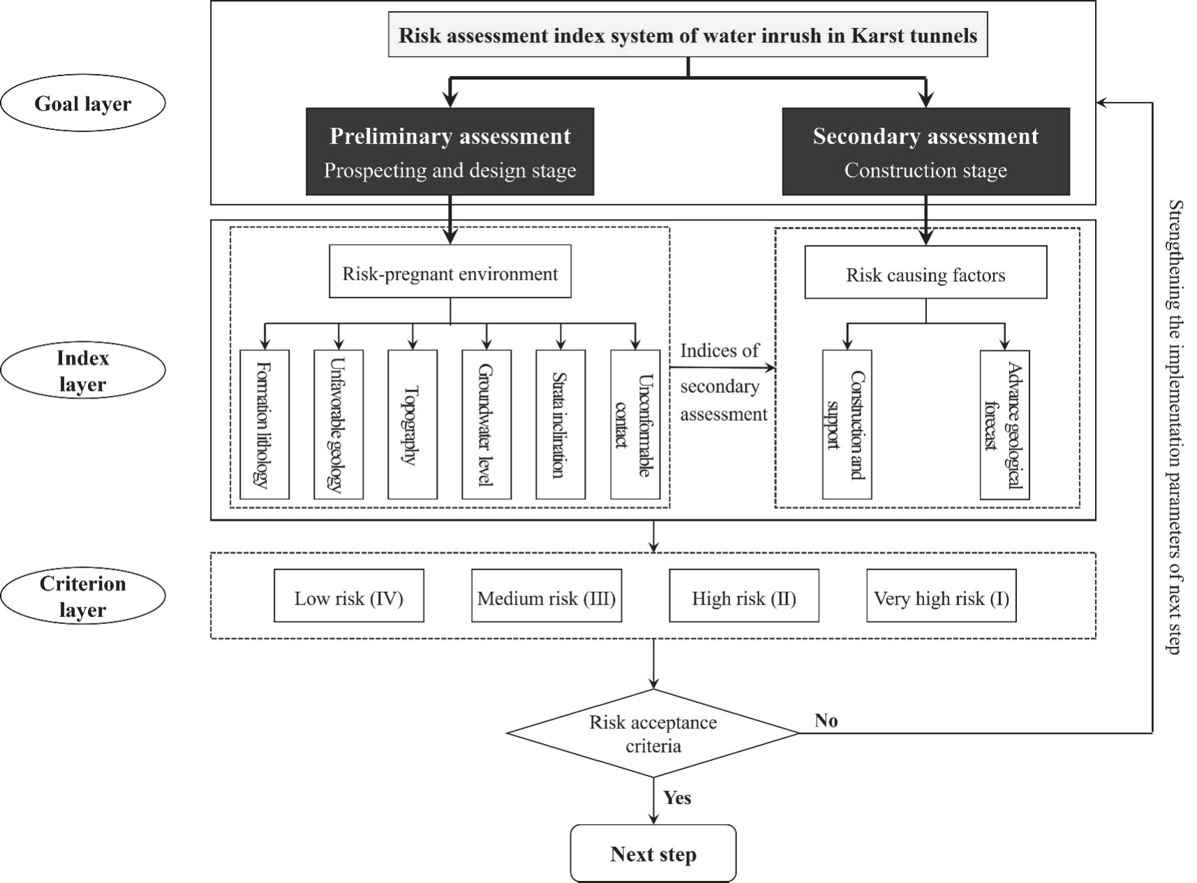
It is well known that the risk of water inrush in the process of tunnel construction is changing. To realize the dynamic identification of the risk, a two-stage dynamic risk assessment method for water inrush in karst tunnels is proposed: the preliminary assessment and the secondary assessment. The preliminary assessment is carried out in the survey and design stage, which can provide a reference for the design. The secondary assessment is carried out in the construction stage, which can provide a reference for the tunnel excavation.
Dynamic Evaluation Index System for Water Inrush
Based on a large number of tunnel water inrush case statistics, the influencing factors of water inrush can be divided into 3 categories: geological and hydrological factors, climatic and environmental factors, and construction and design factors. The geological and hydrological factors include the formation lithology, geological structure, groundwater, topography and geomorphology, rock formation occurrence, and unconformity structural plane. The climatic and environmental factors mainly include temperature and rainfall. The construction and design factors include the excavation method, support measures, advance geological forecast, and monitoring and measurement.
Based on the statistical analysis of the important influencing factors of water inrush, combined with the existing research [18], the dynamic risk assessment index system of water inrush in karst tunnels is established. For the preliminary assessment, the hazard-pregnant environment factors including formation lithology I1, unfavorable geology I2, groundwater level I3, topography and geomorphology I4, dip angle of rock formation I5, unconformity structural plane I6 are selected as the evaluation indices. The construction and support I7, and advance geological forecast I8 based on the hazard-pregnant environment indices are added as evaluation indices of the secondary evaluation. The risk of water inrush from low to high is divided into Level IV (Low risk), Level III (Medium risk), Level II (High risk), and Level I (Very high risk), as shown in Fig. 2.
It is difficult to quantitatively describe the formation lithology I1, unfavorable geology I2, unconformity structural plane I6, construction and support I7, and advance geological forecast I8. Therefore, according to the qualitative grading standard, the expert scoring method is used to quantify these indices. The negative terrain area ratio is used to quantify the topography and geomorphology I4. The dip angle of rock formation 25°~65° is the most favorable for karst development, but the index does not meet the definition of a very large index and very small index. To satisfy the feasibility calculation of the ideal interval evaluation method, the index I5 is corrected. The grading standard of the evaluation indices is shown in Table 4.
Early Warning and Risk Acceptance Criteria
The dynamic assessment results can only reflect the possibility of water inrush, but can not reflect the harm degree. Therefore, the water inflow is introduced to establish a four-color early warning method for water inrush, as shown in Table 5.
To effectively avoid the occurrence of water inrush, the risk acceptance criteria are formulated. That is, the acceptance line is introduced to divide the risk into acceptable area and unacceptable area. When the risk level of the assessment is in the unacceptable area, the support parameters, excavation methods, and monitoring and measurement can be dynamically adjusted to reduce the risk to an acceptable area, as shown in Table 6.
Index Weighting Method
The reasonable weighting method of the evaluation indices is very important for the risk evaluation results of water inrush. Therefore, an integrated method based on subjective weight and objective weight is used to determine the weighting of the evaluation indices.
Where wis is the subjective weight of the index Ii, which is determined by the improved analytic hierarchy process method. wio is the objective weight of the index Ii, which is determined by the improved analytic hierarchy process method. β and 1-β are the distribution coefficients of subjective weight and objective weight, and their specific values are determined by the experts according to the field situation.
(1) The objective weight
Through the frequency statistics of the influencing factors of the water inrush examples, Li et al [9] obtained the objective weights of the evaluation indices I1~I5. That is, (formation lithology I1, unfavorable geology I2, groundwater level I3, topography and geomorphology I4, dip angle of rock formation I5) = (0.188, 0.388, 0.259, 0.109, 0.056). However, the unconformity structural plane I6 is not considered. Its objective weight is determined according to the reference [11], that is w6s = 0.180. The index weights of the preliminary assessment can be obtained by normalizing the above weights:
Table 4.
Indices and criteria for risk assessment of water inrush in karst tunnels.
Table 5.
Four-color warning method for water inrush.
| Four-color warning >10000 | Water inflow (m3·d-1) | ||||
|---|---|---|---|---|---|
| 3000~10000 | 500~3000 | <500 | |||
| Risk level | Level I | Red | Orange | Orange | Yellow |
| Level II | Orange | Orange | Yellow | Yellow | |
| Level III | Orange | Yellow | Yellow | Blue | |
| Level IV | Yellow | Yellow | Blue | Blue | |
For the secondary assessment, the risk-causing factors including construction I7 and support, advance geological forecast I8, are introduced. Their objective weights are determined according to the frequency statistics in the reference [11]. That is, w7s = 0.048 and w8s = 0.192. The objective weight vector of the secondary evaluation indices is as follows:
(2) The subjective weight
The analytic hierarchy process (AHP) method is used to calculate the subjective weight of the evaluation indices. The AHP can give full play to the experts’ experience and knowledge but it also has two limitations: One is that the index weights are easily affected by subjectivity and risk preference. The other is that there are fuzziness and uncertainty in the relative importance between the evaluation indices, and using the single scale to quantify the importance can easily lead to information loss. Therefore, the triangular fuzzy number theory (TFN) is introduced to improve the AHP, and the specific steps are as follows:
a. The triangular fuzzy number Mij = (rlij, rmij, ruij) is used to characterize the relative importance between the evaluation indices Ii and Ij, where rl, rm, and ru represent the lower limit value, the most likely value, and the upper limit value, respectively.
The relative importance between the evaluation indices is quantified based on 1~9 scales method proposed by the Saaty [29]. However, the 1~9 scales method is easy to cause scale confusion and unqualified consistency checking. Therefore, a new 1~5 scales method is proposed to determine the values of rl, rm, and ru, as shown in Table 7.
b. A n-order judgment complementary matrix can be constructed from the triangular fuzzy number Mij, denoted as M = (Mij)n×n. The matrix needs to satisfy:
c. The triangular fuzzy matrix M is defuzzified. Taking Mij = (rlij, rmij, ruij) as an example, its calculation formula is as follows:
d. The AHP is used to solve the subjective weight vector Wo of the matrix R according to the reference [30]. And consistency checking is carried out.
Results and Discussion
Engineering Background of Yuelongmen Tunnel
The Yuelongmen Tunnel is one of the key control projects of the Chengdu-Lanzhou Railway. The tunnel is repaired by two separate lines with a left line length of 19974.3 m and a right line length of 20044.0 m. The maximum buried depth is about 1445.5 m. The tunnel area is located in the central Longmen Mountain Fault zone and passes through the Gaochuanping active fault, Gaochuanping overturned syncline, and Qianfoshan fault. The geological conditions are very complex, and show typical “four extreme and three high” characteristics, namely “ extremely strong terrain cutting, extremely complex and active structure condition, extremely weak and broken lithology condition, extremely significant Wenchuan earthquake effect, high geostress, high earthquake intensity, and high geological hazard risk” [31]. Therefore, engineering geological problems such as active fault, high geostress, large deformation of soft rock, and karst in the tunnel area are significant.
Table 6.
Risk acceptance criteria for water inrush.
Table 7.
The 1~5 scales method.
The section D1K93+440~D2K96+250 of Yuelongmen Tunnel is in the deep circulation zone of groundwater. The lithology is dominated by soluble rocks such as dolomitic limestone, and limestone. The karst is moderately developed. There are several rivers in the tunnel area. The section YD2K94+605~+701 passes through the Suishui River, and the minimum buried depth is about 50m, as shown in Fig. 3. The proposed dynamic risk assessment method based on the new fuzzy interval recognition model is used to evaluate the water inrush risk of the river-crossing section YD2K94+605~+701 in the right line of the tunnel. According to the engineering geological survey, special hydrological survey, and other data of the river-crossing section from the Yuelongmen Tunnel, the measured interval values of the preliminary assessment indices are determined, and the interval values of the secondary assessment indices are modified in combination with geological conditions revealed by the on-site excavation, as shown in Table 8.
Integrated Weighting Determination
The proposed TFN-AHP method is used to construct the triangular fuzzy judgement matrix for the dynamic risk assessment of water inrush in karst tunnels. The matrix is defuzzified and the weighting calculation is carried out. The subjective index weights of the preliminary assessment and secondary assessment are obtained. Moreover, the constructed judgement matrix satisfies the consistency checking, as detailed in Table 9.
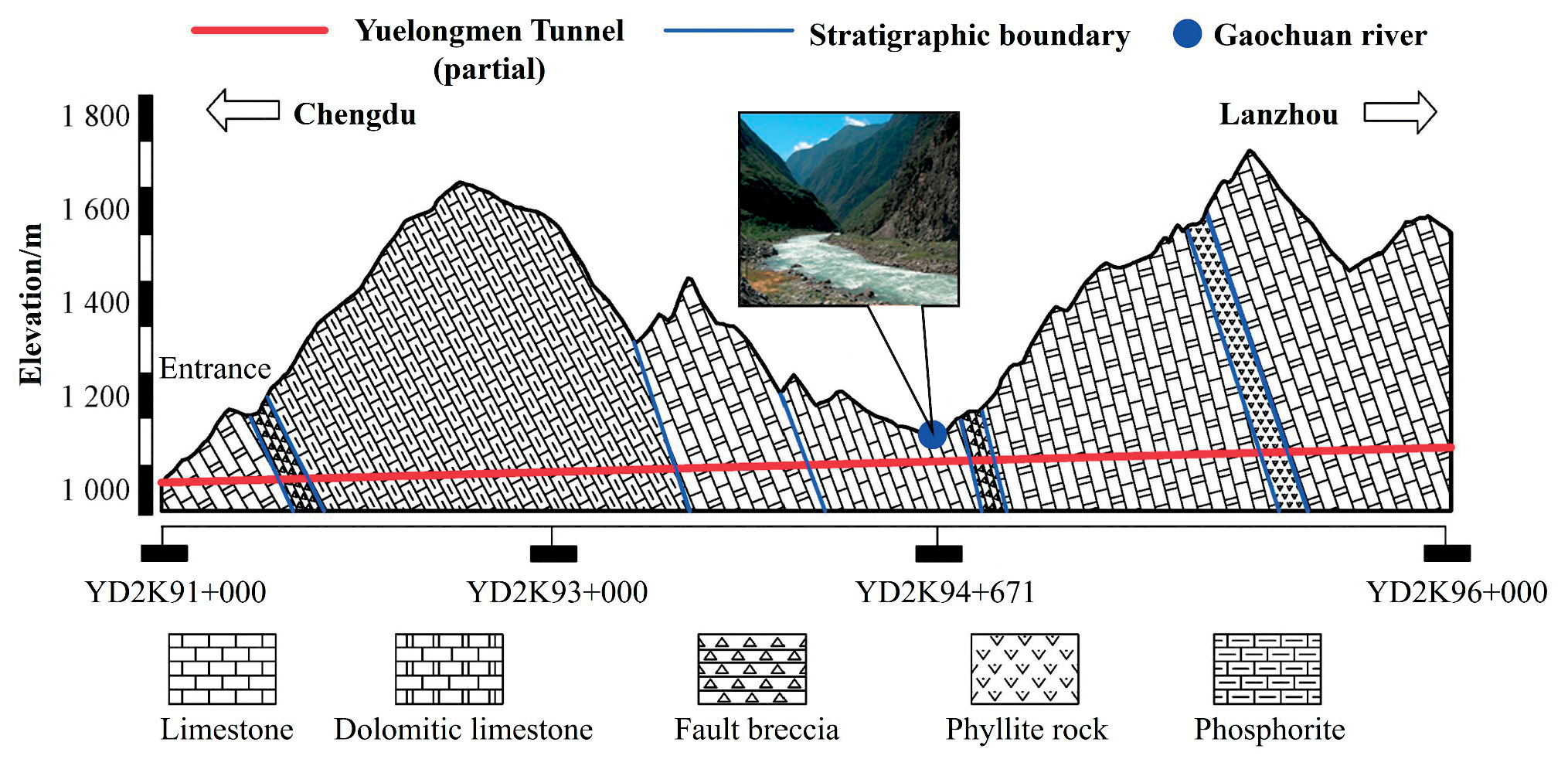
Table 8.
Measured interval value of dynamic evaluation index in the river-crossing section of Yuelongmen Tunnel.
Table 9.
Triangular fuzzy judgment matrix for subjective weights analysis.
The integrated weight values of the evaluation indices are calculated according to the determined objective weights and subjective weights. The distribution coefficient α is selected as 0.5. The integrated index weights of the preliminary assessment and secondary assessment can be obtained as follows:
Positive Ideal Point and Negative Ideal Point
According to the definition of very large index and very small index, the formation lithology I1, unfavorable geology I2, groundwater level I3, topography and geomorphology I4, dip angle of rock formation I5, unconformity structural plane I6 belong to very large index, while the construction and support I7, and advance geological forecast I8 belong to very small index. Then, according to the upper and lower limits of the value range of each index, the positive ideal point matrix F*(+) and the negative point matrix F*(-) of the dynamic risk assessment of water inrush are determined:
(1) Preliminary assessment
(2) Secondary assessment
Risk Grading Recognition
The measured interval values of the evaluation indices in Table 8 are substituted into the Eq. (9)-(14), the distance between the object to be evaluated and the ideal point and the closeness degree of the ideal point are obtained, as shown in Table 10.
According to the interpretation results of advance geological forecast and targeted advanced drilling, it is presumed that the water inflow of the tunnel face is about 7000 m3/d. Based on the warning release criteria in Table 5, the early warning level is orange and the risk is unacceptable. Therefore, it is necessary to stop work and take some measures to control water inrush.
Excavation Verification
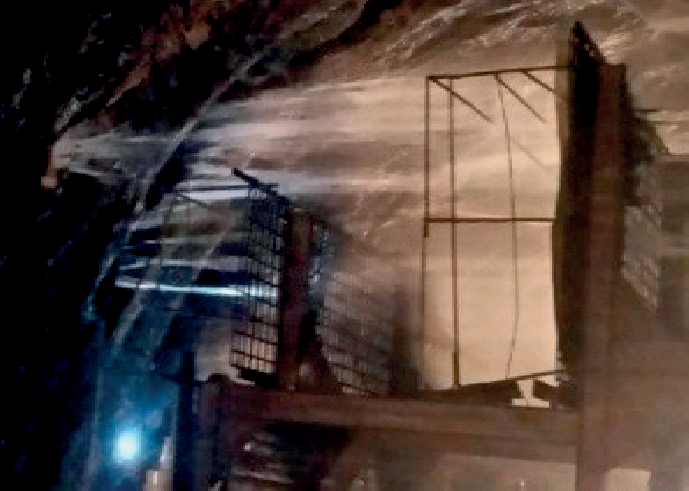
After the excavation of the river-crossing section in the Yuelongmen Tunnel, the water inrush occurs on the arch roof, as shown in Fig. 4. Since the large water-bearing and water-conducting structure is developed in the river-crossing section, the water inrush is fissure-type and the water inflow is about 130 m3/h. The practicability and feasibility of the proposed method in the dynamic risk assessment and control of water inrush is verified.
Conclusions
(1) A new ideal interval recognition model is proposed based on the ideal point method. Considering the complexity and uncertainty of the geological conditions along the tunnel, a small range of continuous interval is used to quantify the evaluation index. The positive and negative ideal points and ideal point functions are improved. And the risk grading criteria based on the ideal point closeness is proposed.
(2) An integrated weighting method of the evaluation index based on AHP and frequency statistic method is proposed. To avoid the scale confusion of the relative importance between the evaluation indices, a 1-5 scales method is put forward. The triangular fuzzy number theory is introduced to improve the subjectivity and risk preference of the AHP.
Table 10.
Analysis of dynamic risk assessment results of water inrush in the river-crossing section of Yuelongmen Tunnel.
(3) To realize the process control of water inrush, a dynamic assessment method is presented, namely the preliminary assessment in the survey and design stage and the secondary assessment in the construction stage. The early warning release criteria of water inrush are put forward combining the risk level and water inflow. And the risk acceptance criteria are developed.
(4) The proposed dynamic risk assessment method of water inrush based on the ideal interval recognition model is applied to the river-crossing section D1K93+440~D2K96+250 in the Yuelongmen Tunnel. The evaluation results are in good agreement with the actual situation, which verifies the practicability and feasibility of the method. The proposed method has the advantages of a clear risk level and dynamic risk recognition.

