

Introduction
The land is a universal natural wealth to people, the use of which ensures food security [1, 2]. The advent of globalization, along with continuing socio-economic development, has brought cardinal changes to the distribution of land resources. Different regions across the globe have seen different trends in this land use change, European countries, for example, currently experience land abandonment [3, 4], whilst China struggles with the lack of land resources due to increasing population and intense construction [5]. The intensification of human activities leads to a variety of environmental problems. Among them are soil degradation [6], water depletion [7, 8], pollution, and biodiversity reduction [9].
The state of food security in the world is regulated by the Food and Agriculture Organization of the United Nations (FAO)/World Health and the Organization (WHO) Expert Committee on Food Additives (JECFA) [10]. Developed and developing countries that participate in the FAO forums work together to adopt appropriate political solutions to combat hunger and improve agricultural practices, forestry, fisheries, and food security. Addressing malnutrition and hunger is one of the most important Sustainable Development Goals [11, 12]. While large-scale food production does not guarantee an even distribution of food among the population, having access to a sufficient quantity of food is a prerequisite for food security. One way to solve the food crisis is to increase the area of arable land through grassland conversion, but it is not the best solution, as it leads to soil degradation, pesticide and nutrient leaching, and the release of carbon emissions [11]. In recent years, researchers have been increasingly searching for ways to improve land-use efficiency that could provide food security and meet the growing demand for food, animal feed, biomass and bioenergy in the world [13].
A sustainable farming system is a result of meaningful land use research, which, in turn, requires scholars to optimize their research approach [14, 15]. The focus, in this case, should be on factors that may influence agricultural land-use efficiency (LUE). The said parameter can be defined as the ratio of yield obtained from a particular land area to reference yield, or previous yield [16]. Primarily, the LUE analysis includes the following measures: yield potential, product quantity, quality and function [13, 16, 17]. The comparison among different farming systems (organic farming, conventional farming and agroforestry) evaluated using this approach in Germany revealed the highest level of efficiency with conventional models. In addition, the researchers emphasized the importance of considering agri-environmental indicators when supporting effective and sustainable farming [13].
As for factors that influence the agricultural output of a region, there are many of them [18]. Those include geographic location, topography, soil structure and composition, geological and engineering processes, agro-technologies, and labour productivity, to name a few.
The estimation of land-use efficiency may involve different procedures; one of them is the combined use of geographic information systems (GIS) and the logic scoring of preference (LSP) method [19-21]. It allows examining a wide range of evaluation criteria by using GIS tools and expert reasoning [22]. In the past, however, land use studies considered a small set of parameters, and the factor of human reasoning was absent [23, 24]. Ultimately, concepts encompassing the adequacy or efficiency of land utilization are inherently subjective, and their quantification eludes direct empirical assessment. Consequently, scholars resort to the strategic approach of expert analysis as a means of investigation [19].
Land use efficiency exerts an influence on agricultural production, structure, and quality, as posited by previous scholarly discourse [18]. The commonly accepted indicator of agricultural efficiency is the volume of gross output per unit area. In the European Union, it is assessed by exploring the dynamics of agricultural land use and crop production, along with the ratio between production and gross value added per unit area [18, 25]. This approach motivates farmers to strategically refine their land use practices, intending to augment agricultural production and maximize gross value added per unit area, as highlighted in previous scholarly discussions [18]. In the Russian Federation, the efficiency of land use is evaluated using economic and mathematical models to optimize the cropland structure [26], and the evaluation process includes additional ecological criteria. Consequently, the economic and social welfare of the population depends on how well the efficiency of land use is estimated and predicted.
Mountains occupy about 12.5% of the Earth’s land surface, provide habitat to one-third of terrestrial species, and are a source of fresh water, not to mention their cultural value; hence, they have become the focus of international policy efforts, aimed at supporting the sustainable development of mountain systems [27]. The available literature points to the importance of mountain areas in providing ecosystem services: they participate in climate regulation and air quality regulation at global and local levels, as well as in food provision (through farming, livestock and fish cultivation, and biomass production), energy and mineral resource supply [28-30]). Mountain areas have recently been singled out as a separate subject of legal regulation and received legal support as regions essential for sustainable development [31].
In temperate and higher latitudes, as well as at elevated altitudes, an augmentation in agricultural productivity may be observed contingent upon the cultivated crop varieties, vegetative periods, precipitation levels, and temperature fluctuations [32, 33]. For instance, in the context of mountainous regions of the Himalayas, it has been reported that the elevation in average temperatures due to climatic shifts has the potential to expedite the development and growth of winter crops, consequently enhancing crop yield [32]. Elevated levels of agricultural output are attainable only under the prerequisite of adequate soil moisture content. The intricate interplay between soil moisture and vegetation growth is particularly pronounced within arid desert regions [34].
This study aims to quantify the spatial variability in agricultural land use and to build a mathematical model of land use efficiency in the mountainous regions of the North Caucasus and Crimea. The secondary objective of the study is to identify the main factors behind land use variability. Note that mountain areas have more economic risks associated with the development of unfavourable engineering-geological processes than flat land, and the topology is also different [35, 36].
Methods and Materials
The study area covers the mountainous systems of the Crimean Peninsula and the North Caucasus. Despite the presence of mountain ranges, these regions are characterized by small hypsometric heights (up to 500 m), favourable to agriculture, a warm climate, sufficient precipitation levels, and fertile soils. All these factors contribute to high levels of agricultural production in certain regions.
The North Caucasus (Fig. 1) occupies southeastern European Russia with a strong natural resource base and intensive agriculture [34]. The climate is moderate, with hot summers, mild winters, and sufficient precipitation. The region has a high population density, mainly agricultural employment, underdeveloped industry and education, and frequent inter-ethnic and religious conflicts. Agriculture accounts for 80% of the area, and livestock is predominant (70% and 30%, respectively). Agriculture, however, is hardly considered ultra-modern. The indicators of mechanization, the use of mineral fertilizer, and modern farming techniques are the weakest in Russia. As a result, agricultural productivity is maintained through climate and fertile soils.
The mountains of Crimea are located to the south and southeast of the Crimea peninsula (Fig. 2), and their size is several times smaller than the Caucasus Mountains. They spread over 180 km from west to east and 60 km from north to south. The region experiences a temperate and subtropical climate, with the primary economic drivers being the healthcare and tourism industries. The steppe and piedmont areas in the Crimea-Caucasus region are good for agricultural practice [37], which cannot be said about the mountainous areas, where conditions are less favourable.
The agricultural area of the North Caucasus (Fig. 3) amounts to 1,350,333,000 m2 [37], with the highest shares in the Stavropol province (61,086,000 m2) and the Karachay-Cherkess Republic (8,172,000 m2), and the lowest in the Republic of Ingushetia (1,507,000 m2) [37]. Among the most cultivated plants here are grain crops, followed by fruits and vegetables (harvested in the foothills), sunflowers, and sugar beet.
The area of agricultural land in the mountain areas of Crimea is approximately 1 700 000 m2 [38] The most used areas are located in the Simferopol (525 000 m2) and Belogorsk (306 000 m2) districts (Fig. 4), and those used less situate in the coastal areas of Black Sea – in Alushta (7,000 m2), Sudak (5 000 m2), and Yalta (0 m2) [38].
Among the most cultivated plants here are cereals and legumes, followed by sunflowers, potatoes, and other vegetables [39]. Their yield correlates well with the application of mineral fertilizers, with a correlation coefficient of 0.81.
The topography of a mountain area heavily determines the variability in farmland use [40]. A correlation exists between the steepness of the terrain slope, the type of land development, and the advent of unfavourable processes (Table 1) [41].
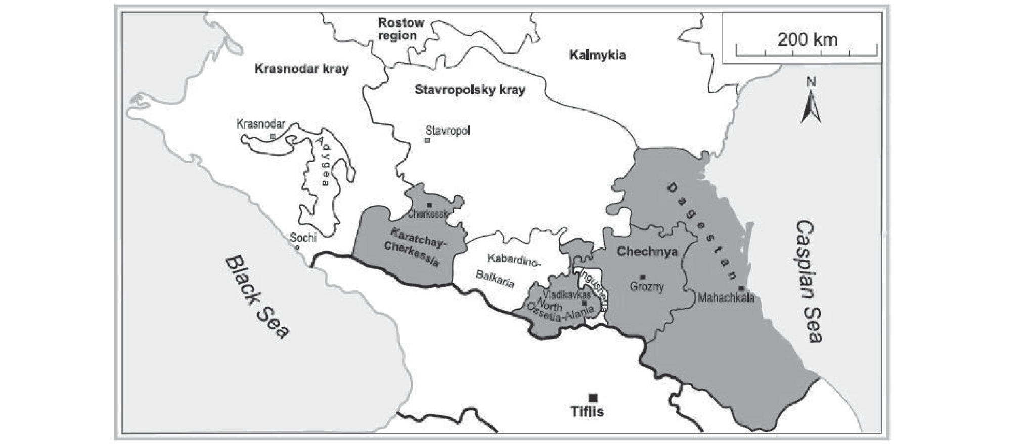
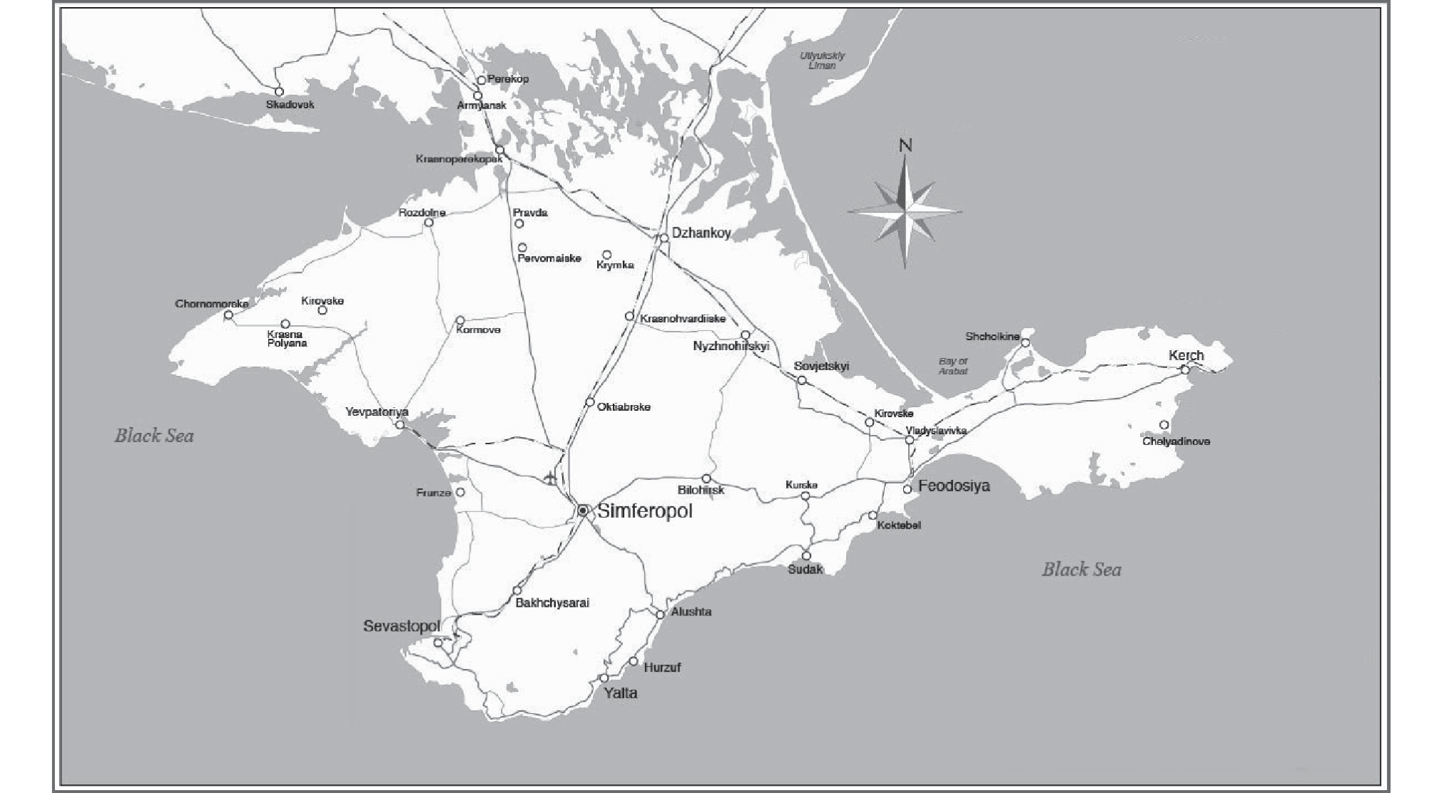
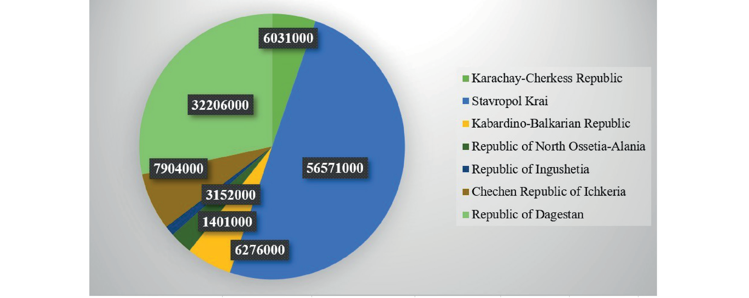
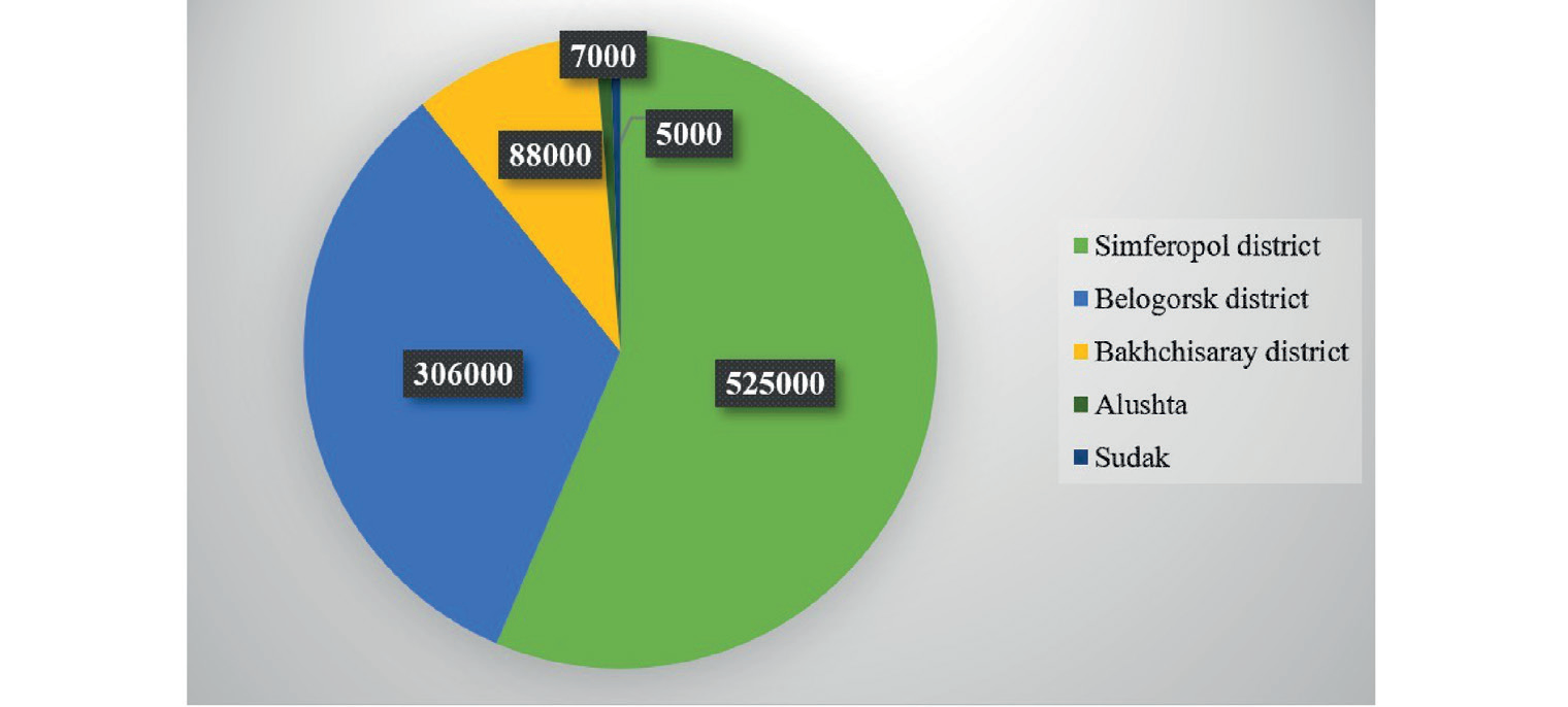
Table 1.
Effect of terrain gradient on agricultural development.
Hypsometric levels affect yields as well. For instance, the content of humus, nitrogen, phosphorus, and potassium on the lower slopes is higher than on the upper slopes. However, this distribution pattern may be due to soil movement from higher to lower areas under the influence of gravity. The proposed model of land use efficiency considers the relief and presence of adverse processes using the vulnerability factor.
Method
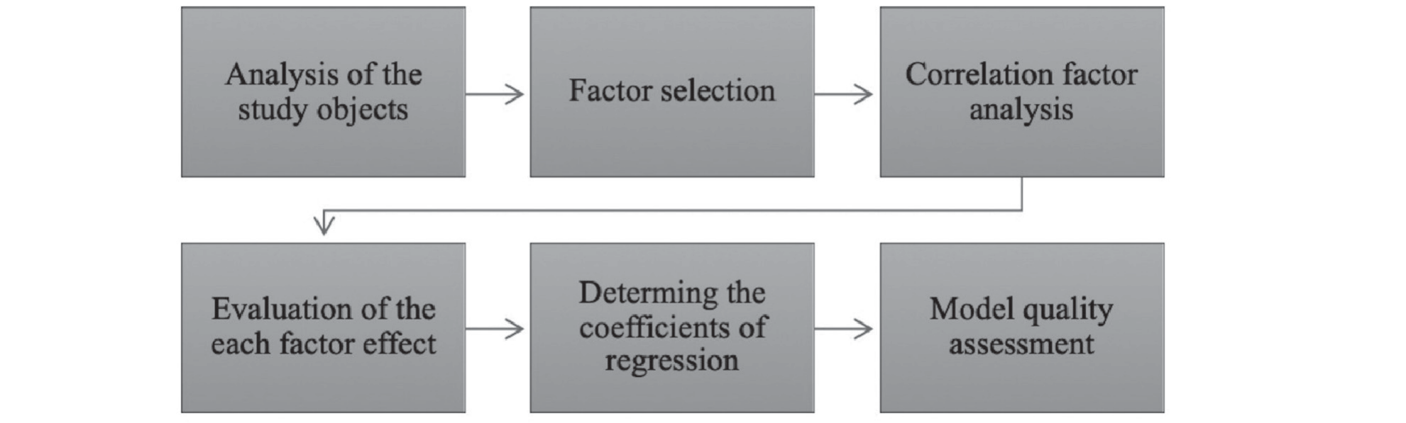
The modelling procedure involves factor, correlation, and regression analyses. The proposed model measures the extent to which factors influence the cadastral value of agricultural land. The criterion for selecting factors for the model was the degree of correlation. A correlation coefficient of <0.3 indicates a weak correlation between variables; a correlation coefficient of 0.3-0.7 indicates a moderate correlation; and a correlation coefficient >0.7 indicates a strong relationship between factors [42]. Of the 30 factors considered, only 14 factors with a correlation coefficient of more than 0.7 were included in the final model. The complete list of factors is presented in Table 2.
The primary data sources were the Federal State Statistics Service [43] and the UN Food and Agriculture Organization [44]. Factors 11 to 14 were obtained by calculation using data from the Federal State Statistics Service [43].
The equation for regression analysis is:
where: х1, … х𝑛 are factors, and а0, а1 … а𝑛 are coefficients of regression determined by the ordinary least squares method [45].
By the previously tested methodology [16], the saturating fertilizer application, or the limiting factor (X11), is a dimensionless value. Mathematically, it is given as:
where: FrHa is the amount of fertilizer applied per ha, and HS is the half-saturation coefficient found for each product separately in the available literature [44, 46, 47].
Yields per ha after fertilization (X12-X14) are determined using the following formula [16]:
where: NFrHa is the crop yield per ha without fertilizer, SR is the scope of crop response to fertilizer use, and EF is the erosion factor.
The study algorithm is shown in Fig. 5.
Table 2.
The factor structure of a multi-factorial research model.
Nearly 27% of the farmland in the North Caucasus is susceptible to erosion [45], which significantly reduces crop yield. The study area is also characterized by adverse events, such as landslides (which occur almost in every region under study, particularly in the Chechen Republic and Stavropol Krai), mudslides, rockslides (especially, in Stavropol Krai), karst soil erosion, deflation, and excessive water [48]. As the mountains are young, earthquakes may occur. One of the typical features of mountainous terrain to be considered when studying the LUE is the terrain gradient [48].
The procedure of land-use efficiency modelling in this study takes into account these risks by using the vulnerability factor [45]. Mathematically, it is given as:
R = Yt Ys Ky S where: R is an overall economic risk, Yt is the dynamic soil vulnerability factor, Ys is the spatial soil vulnerability factor, Ky is the structure vulnerability factor, S is the value of fixed assets within the area.
The one-way analysis of variance (ANOVA) is used to determine whether there are statistically significant differences in LUE between the Mountainous Crimea and the North Caucasus. Data for multi-factor regression was analyzed in Microsoft Excel.
Results and Discussion
Mathematical Modelling
The results of mathematical modelling are presented in Tables 3-5. As can be seen from Table 3, the accuracy of the proposed model is 0.987656, indicating a high accuracy of approximation.
The overall quality of the proposed model is described by ANOVA. The Significance F is less than 0.05 (Table 4), suggesting that the model is significant.
Table 5 shows Linear Regression Results. Column 2 displays the standardized coefficients (β) of the model. Column 3 shows the standard errors (SE). Column 3 presents the t-statistics. Column 4 represents the p-values.
In this study, 14 regression equations were solved. The coefficients of regression а1 … а14 were derived by resolving the system of equations. When the direct dependence between x and y was observed, the values of a were positive, and in the case of inverse dependence, the values were negative.
Using the equation (1), the LUE value was determined: LUE = 78,619 + (15.6 * х1) + ((-33) * х2) + ((-5.1) * х3) + (83 * х4) + (262 * х5) + (84 * х6) (16.1 * х7) + (33.5 * х8) + (5.1 * х9) + (83 * х10) + (262 * х11) + (92 * х12) + (-76) * х13) + ((−0.59) * х14)
Table 4.
ANOVA findings.
| df | SS | MS | F | Significance F | |
|---|---|---|---|---|---|
| Regression | 14 | 612663386.5 | 41365562.87 | 587.0647 | 0.0017145 |
| Residual | 2 | 130965.7478 | 58965.37753 | ||
| Total | 16 | 5912675246.5 |
Table 3.
Evidence from multi-factor regression.
| Multiple R | 0.968347 |
|---|---|
| R-square | 0.987656 |
| Adjusted R-square | 0.978092 |
| Standard Error | 256.9184 |
| Observations | 16 |
Table 5.
Linear regression results.
Calculated Land-Use Efficiency by Year
The results for each region are presented in Table 6. The first column indicates the year when the input data were reported, and it is followed by two columns that display the LUE values for the Mountainous Crimea and the North Caucasus, respectively.
The ANOVA analysis revealed no significant differences in dynamic LUE for both regions (p-value = 0.053, p<0.05). There is an upward trend in each district that preserves from year to year, and the average value of LUE in the Mountainous Crimea exceeds that for the North Caucasus.
The scientific innovation of the article lies in the complex and multifactorial study of the LUE in the mountains of Crimea and the Northern Caucasus, considering the particularities of the mountainous terrain.
The correlation analysis identified 14 factors that may impact LUE. Among them are the gross production and per capita consumption rates of grain, vegetables, fruits and berries, fertilization, and the area under crops and livestock [45]. Subsequently, the effect of each factor on LUE was estimated.
The mathematical model used in this study makes it possible to evaluate the degree of LUE in each district and quantitatively examine the factors affecting it. By altering the value of an individual factor, one can trace its impact on land-use efficiency.
According to the analysis, the leading factors affecting the efficiency of land use in the mountainous regions under consideration are the gross harvest and yields of specific agricultural products, cultivated area size, and fertilizer application. This finding is in good correlation with similar international studies [18].
Table 6.
Calculated land-use efficiency by year.
Agricultural Land-Use in Mountainous Crimea
In mountainous Crimea, the most commonly cultivated crops are cereals and legumes, sunflowers, potatoes, tomatoes, and other vegetables. The farmland here extends to approximately 1,700,000 m2, concentrated mostly in the Simferopol, Belogorsk, and Bahchisaray districts. The yields were found to be strongly correlated with the amount of fertilizer used, with a correlation coefficient of 0.81 and a p-value of 0.01. This finding supports the idea that intensive use of fertilizers can boost yields [48]. Hence, it can be deduced that areas with greater crop yields are likely to exhibit elevated levels of soil pollution attributed to nitrogen and phosphorus.
On the one hand, the application of nitrogen and phosphate fertilizers to the soil in mountain areas will make no significant difference. The reason is the loss of nitrogen during surface leaching, which can reach 40%. On the other hand, if farmers could optimize the number of nitrogen fertilizers, they would reduce erosion [49], which is typical of Crimean and Caucasian soils. Previous research shows that organic fertilizers are as effective in promoting potato production as chemical ones, more effective in sunflower production, and less effective when applied to soils under other vegetables [38, 50]. Therefore, a natural solution for the mountainous regions in Crimea and the Caucasus may be the transition to organic farming.
Agricultural Land-Use in the North Caucasus
In the North Caucasus, the agricultural land occupies 1,350,330.00 m2, with the biggest areas in Stavropol Krai and the Karachay-Cherkess Republic focused mostly on growing cereals, fruits, vegetables, sunflowers, and sugar beets [51].
Assessing the agricultural land-use opportunities in the North Caucasus, the regression analysis revealed a persistent upward trend in agricultural LUE. The regression model does not include population counts as an LUE factor due to the steady growth of inhabitants in the North Caucasus region. In international studies [6, 36, 52], the population factor is considered to resolve spatial and temporal problems. However, there is generally no increase in population density recorded in those studies; in fact, the opposite trend can be seen. Some scholars tend to distinguish between rural and urban areas [53] based on their environmental and economic characteristics. This study does not intend to divide the investigated area by urbanization level.
Within the context of the Ghanaian investigation [13], wherein yield measurements were conducted in a similar manner, a recurring trend of annual escalation in food production is evident. The intensification of fertilizer application is not typically seen in Ghana, so the primary explanation for the growth of production could be the expansion of agricultural land. Another study [54] explains the increase in yield by linking it to the use of improved high-yielding crop varieties. In the present study, yield increment is most likely associated with a combination of factors, ranging from an increase in the number of fertilizers applied and the integration of high-yielding selection achievements to suitable farming conditions (especially on the Crimean Peninsula) and the absence of adverse natural processes and phenomena.
The proposed model makes it possible to consider the natural and climatic characteristics of the study area. The North Caucasus and Crimea are characterized by a warm climate, large precipitation, mountainous terrain, and unfavourable events, such as erosion, landslides, mudflows, and stoniness [35, 55]. Even though there are mountain ranges in the area, the share of slight slopes is higher, and they do not impede agricultural activities. The summers here are warm, and winters are not cold. The western winds bring enough moisture from the Atlantic Ocean. The population of the Caucasus continues to increase, and since most of the population is engaged in agriculture, the agricultural sector performs well. The secondary advantage of the envisaged assessment model lies in its utility for making judicious managerial determinations concerning the allocation of agricultural land resources.
A coherent system of regional monitoring is required to prevent land degradation. Achieving sustainability in agricultural development requires considering the wide range of regional characteristics, including topography, climate, and unfavourable events. Liu et al. [7] concluded that coordinated development of the city and countryside is an optimal model under the “new normal” of the economy, which has replaced the phase of active growth. The need to move from state monopoly to Multi-Actor Management has been questioned previously, and the colleagues decided on taking steps towards optimizing the environmental legislation with subsequent coordination with land and civil regulations. The involvement of local communities (ethnic groups, tribal and family unions with close internal ties), in this regard, is deemed crucial [51, 56, 57].
A pressing inquiry revolves around the pursuit of more effective utilization of agricultural landscapes. Prospective catalysts for enhancing land use can be gleaned from the work of Bhatti et al. [58]. The researchers undertook an analysis of spatial autocorrelation and spatial panel regression of deleterious air pollutant emissions [58]. Spatial effects within the econometric framework of panel data were examined across diverse regions of China [58]. A significant pivotal inference drawn from the study by Bhatti et al. [58] for this investigation underscores a notably positive association among variables such as urban population influence, urban greenery, economic growth, and economic expenditures, although outcomes exhibited disparities contingent upon regional typology.
In the realm of environmental management, cartographic delineation of valuable mineral resources, urban land-use target detection, as well as agricultural and forestry administration, are increasingly reliant upon classification methods predicated on hyperspectral images [59]. To attain robust accuracy under conditions of limited datasets, Bhatti et al. [60] have proposed the amalgamation of 3D graph convolutional networks and Graph Attention networks. Such an approach facilitates the utilization of each discrete feature alongside the cross-information existing among distinct features, substantially augmenting recognition capabilities [60].
In a separate study, Bhatti et al. [61] conducted an analysis of the graph convolution network (GCN) as an innovative artificial intelligence technology across various research domains over the past two decades. Bhatti et al. [61] provided a comprehensive and organized examination of recent progressions in GCN methodologies, offering a hierarchical and structural overview. Moreover, they amalgamated insights to facilitate the utilization of GCN for the modelling of graph data. The authors propose the abstraction of numerous intricate network communication issues as graph-based optimization tasks, addressing them through the application of GCN [61].
Limitations
This study has some limitations. First, the geographic scope of the study is narrow, limited to just two mountain areas: Crimea and the North Caucasus. Second, the Mountainous Crimea has a much smaller area compared to the North Caucasus – the study covers 5 spatial units. If the work focused solely on Crimea, it would not be sufficient, but when analyzing the peninsula next to the other 7 regions in the North Caucasus, the paper seems to be more informative. Third, multiple regression ignores spatial autocorrelation, but given the absence of comparison among individual settlements in the Mountainous Crimea and the North Caucasus (the focus is on regions in general), it seems to have acceptable feasibility.
Furthermore, it should be noted that the final variables in the model presented in Table 2 pertain exclusively to agricultural production. The absence of environmental factors (such as climatic precipitation, soil fertility, erosion risk, and degree of slope) within the model somewhat constrains the practical implications for spatial differentiation across regions.
Conclusions
The spatial variability of agricultural land use within mountainous areas depends on the following factors: yields and gross harvest of specific crops, cultivated area size, and the volume of fertilizer usage. The present findings confirm the widely accepted view that crop yields are directly correlated with fertilizer application. By employing a mathematical framework, this investigation evaluated the viability of the cultivation of crops within mountainous terrain. Despite the attendant economic uncertainties, an augmentation in land utilization efficiency was observed.
The generally accepted approach to LUE estimation takes into account the volume of gross production per unit area, while the model proposed in this study integrates a range of natural and climatic characteristics, such as weather conditions, relief, and unfavourable exogenous-geological processes that can lead to land degradation. Thus, the model can help improve and optimize the use of land and agricultural decision-making. The preservation of the environmental stability and the well-being of the local population will depend on the accuracy of land use decisions.
The present work shows that it is possible to engage effectively in agriculture in mountain areas, but it will require a working resource, a favourable climate, and a rational approach. The findings of this study hold significance in elucidating the Land Use Change (LUC) dynamics within the mountainous agricultural ecosystem. Through the utilization of the developed model, the feasibility of conducting evaluative computations contingent upon specific values of factors X1...X14 emerges, encompassing the manipulation of numerical values of individual factors as well as their temporal variations. It is anticipated that such an approach will facilitate the optimization of land resource utilization within the framework of evolving environmental conditions and population growth. The proper management of erosion, landslides, and other unfavourable events, coupled with organic farming and mechanization, will allow for reaching even greater land-use efficiency.

