

Introduction
Villages have unique spatial characteristics, embodying the local traditional culture, architecture, and spatial form of villages and towns [1, 2]. They also reflect the harmonious relationships between villages and the surrounding natural environment [3- 5]. The unique type of external spatial form is one of the important features of the spatial characteristics of the village [6-8]. The boundary range is an important basis for the delineation of the type of external spatial form of a village [9-11]. The village plan sets out a conservation boundary for the village in order to protect its character. In order to promote the development of the villages, the characteristic spaces of the villages are introduced to these areas as potential tourism resources to activate the local economy [12, 13]. As a result, in addition to conservation projects, hotels, exhibition halls, event centers, reception centers, and other non-village projects have emerged in the villages to serve the tourism industry. The typical rural plan, however, is only a master plan for the long-term social, economic, scientific, and technological development of the village itself and does not make additional arrangements for the deployment of a large number of non-village functions [14, 15]. Thus, the single boundary delineated by village planning is unable to cope with the construction needs of diverse non-village functions. The failure of the control role of village planning boundaries has led to encroachment on village boundaries from time to time. Appropriate, location-specific spatial conservation and adjustment as well as moderate spatial development to preserve local identities are in high demand, rather than a one-size-fits-all plan [16]. Therefore, it is of great significance for the development of the village to delineate multiple boundaries. It can guide the projects to be built without affecting the village’s protection.
There are two main methods of delineating village boundaries: macro- and micro-level methods. The macro-level method uses remote sensing data as the basis for large-scale feature identification to delineate village boundaries. For example, Wang et al. use remote sensing data to quantify changes in the boundaries of rural settlements. This data can detect the disappearance, shrinkage, expansion, and merging of villages [17]. Huang et al. adjusts the delineation results with village administrative boundaries in the delineation of urban growth boundaries (UGBs) [18].
There are two methods of delineation at the micro-level. One method is the delineation of village boundaries through field research measurements with the participation of local residents. For example, Chamara J. et al. used PGIS interviews and group discussion methods with participatory resource mapping (PRM) steps to delineate land boundaries along the eastern boundary of Wilpattu National Park in Sri Lanka [19]. Beccy et al. used circular buffers, unweighted Voronoi polygons, and multiply-weighted Voronoi polygons to delineate village boundaries in West African agricultural landscapes [11]. Oliskiewicz-Krzywicka described the origins of village boundary shapes formed in the Middle Ages and introduced the rules for boundary delineation [20]. Xu et al. studied the Hongcun boundary formation process through interviews and observations [21].
A second method is to delineate the village boundary by using the closure curve. For example, Pu used three different imaginary boundary scales of 100, 30, and 7 m to set the planar closure graph of the settlement boundary [22]. Lu used 200, 30, and 12 m imaginary boundary scales to delineate the village boundaries [23]. Dong found the boundary of the village by using the building node network graph to find the convex packet between two buildings within a specific influence distance [24]. Zhang applied the Delauany triangular network principle to visualize the spatial relationship of buildings, the minimum spanning tree algorithm, and the convex packet principle to extract the village boundary [25].
Despite the large body of methodologies for delineating village boundaries, they are only capable of delineating one to three village boundaries in the aforementioned research methods. Delineating village boundaries by employing remote sensing data is done to distinguish the differences between the built-up areas of villages and the surrounding natural features and is a macroscopic delineation method with poor accuracy for solving microscopic boundary problems. The method of field research, which is done through residents’ participation and on-site measurement, solves the specific problems of village boundaries, albeit with lower efficiency and is not universal. The method of the closed curve, although able to solve the problems of accuracy and universality, can only delineate three boundaries and is slightly inferior for solving the need for multiple boundaries in villages.
The purpose of this study is to provide a strategy to delineate flexible boundaries for the conservation and development of villages. This paper aims for this strategy to provide a more precise and flexible quantitative idea, with a view of achieving a balance between conservation and the development of villages. This study takes a micro-level view of individual villages to delineate multiple boundaries for villages, using the length of virtual line segments as control parameters. Then, the study constructs a framework for the mathematical and theoretical relationships between the length of virtual line segments of optimal boundaries for villages and the classification of external spatial forms. Finally, the study provides a range of control parameters when delineating flexible boundaries for villages with different spatial form types. We verified the validity of the framework by using 20 traditional villages in the Yiluo River basin as empirical subjects. The workflow of this study is shown in Fig. 1. We have designed this study methodically to draw concise conclusions that facilitate the application of village planning practices. These results can be widely applied by those involved in village planning practice. It can also be read by all participants in the development of villages and can help villages make their own decisions in the process of conservation and development.
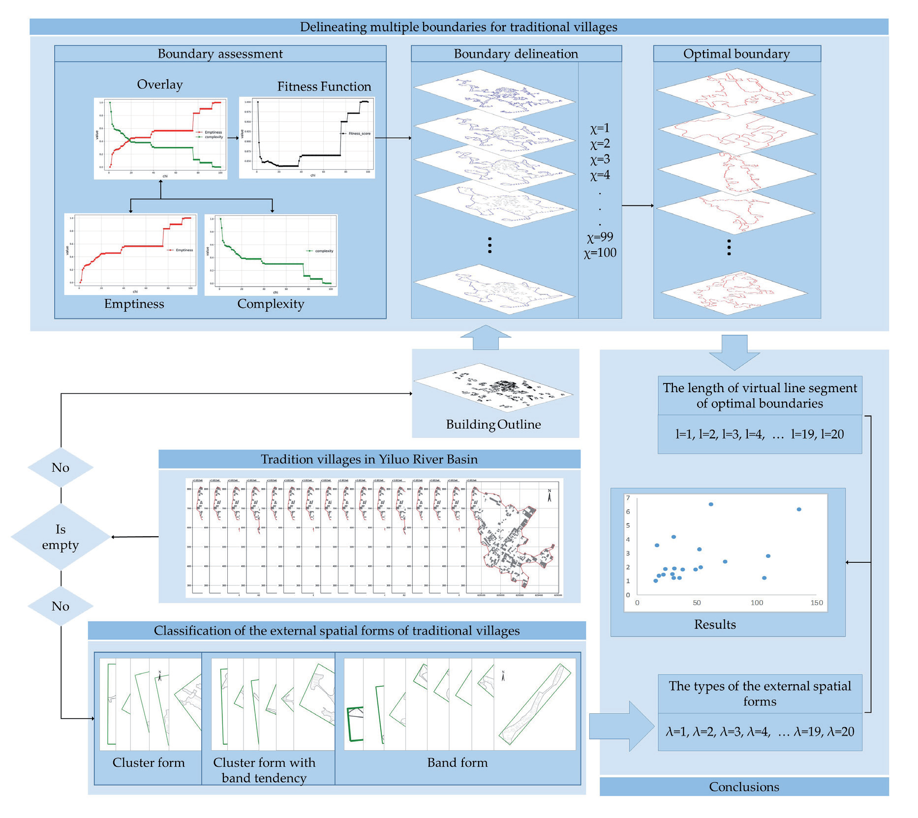
The remainder of this paper is structured as follows: In Section 2, we introduce the study area and describe the data and data-preprocessing steps; in Section 3, we present the methods; in Section 4, we present the results and discussion; and in Section 5, we draw conclusions.
Material
Study Area and Data Description
The Yiluo River region has long been regarded as the birthplace of the Chinese people in the Yellow River basin and is associated with the process of early state formation and the emergence of the first dynasties of ancient China [26-28]. Therefore, the area of the Yiluo River basin has been praised by many historians as the “Two Rivers Civilization of the East”. The Yiluo River Basin is an important first-class tributary of the middle and lower reaches of the Yellow River (Fig. 2a), the second largest river in China, known as China’s “Mother River”. The Yiluo River valley is a vast, fertile alluvial basin. The Yi and Luo rivers flow from SW to NE through the basin and join together, forming a single channel known as the Yiluo River, before emptying into the Yellow River [29]. The basin is bound on the north by the Mangling Hills, which separate the Yiluo Plain from the Yellow River, and is surrounded by mountain ranges on the other three sides, including the Xiaoshan, Xiong’er, Funiu, and Songshan mountains running W-E, reaching 500–2000 m in altitude [29], which is well suited for human habitation and reproduction. The Yiluo River Basin has a complex topography with many rural settlements.
More than 5,000 years ago, China’s ancestor, the Yellow Emperor, established an early unified clan-tribal confederation here, and here the early systematic culture of Chinese civilization was born, which has continued uninterrupted to the present day. Heluo culture is the source and core of Chinese traditional culture, constituting the most important part of Chinese traditional culture; Heluo culture is the central culture, the capital culture, the national culture, and has long been in a dominant and central position; Heluo culture is orthodox, pioneering, open, compatible, and stable. In short, Heluo culture is the root culture and mother culture of the Chinese nation. The Yiluo River basin is at the heart of the River Luo culture.
Traditional villages are villages that were formed earlier, possess rich traditional resources, are relatively complete at present, and have high historical, cultural, scientific, artistic, social, and economic values [30, 31]. They not only function as historical and cultural heritage, but they also provide a venue for promoting the construction of ecological civilization, condensing historical memory, and reflecting the progress of civilization [32-34]. To protect the characteristics of the villages and guide their development, China has redefined the meaning of traditional villages, established a mechanism for the selection of traditional Chinese villages, and published the Traditional Village Evaluation and Recognition Index System [35]. As of March 2023, six batches of 8,155 villages have been officially included [36].
Therefore, the paper selects all national-level traditional villages in the Yiluo River basin as the research object (1-5 batches), which can satisfy the requirements of representativeness, stability, diversity, and uniqueness of the sample. The villages and their locations are detailed in Fig. 2b), respectively.
We obtained the building outline data for the villages from publicly available government village-planning documents and Google Earth satellite aerial photography. We preprocessed this raw data using AutoCAD and ArcGIS software. The data for each village comprised the outline plan of all buildings in the village, the spatial relationships of the buildings, and the geographic coordinates of the buildings. We extracted the data for each village based on the natural agglomerated clustering state of the settlement, which may slightly deviate from the administrative division of the village.
Methods
Method of Delineating Multiple Boundaries of Villages
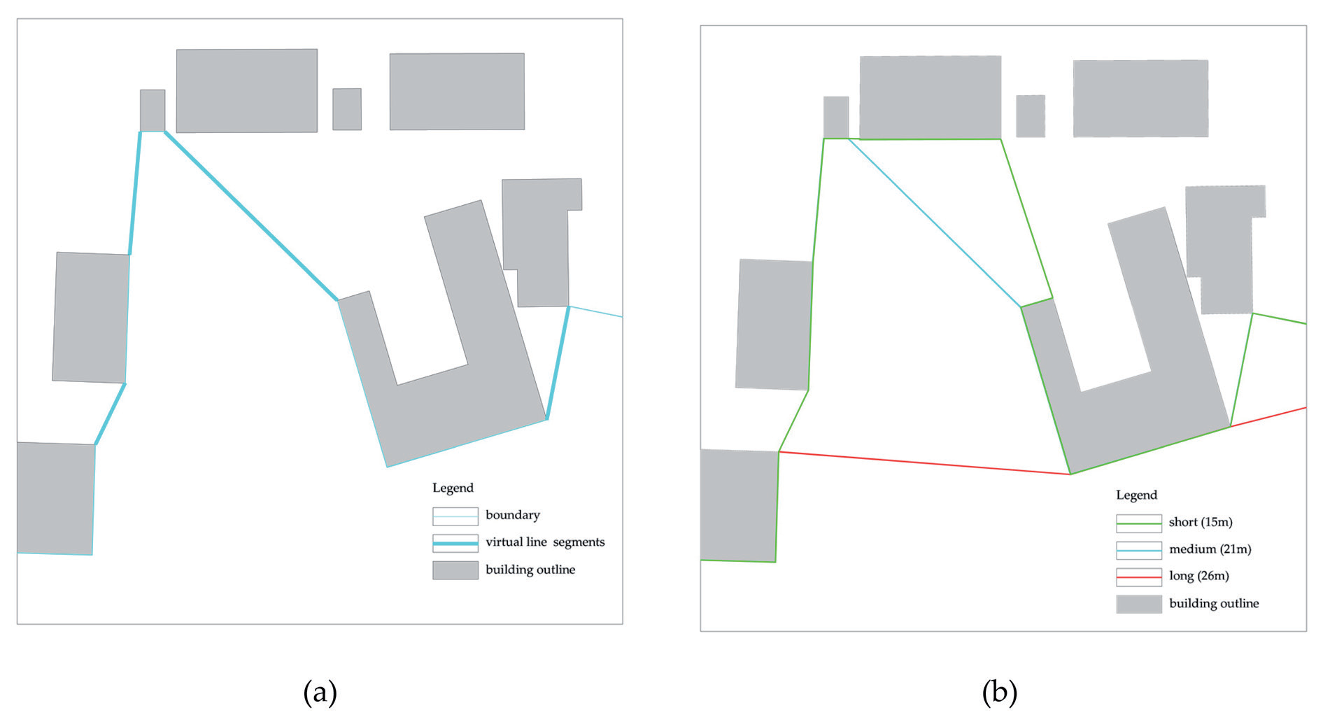
The diversity of village boundaries is determined by the diversity of virtual boundaries. These boundaries manifest in some old villages as solid structures, such as walls and moats, but these are relatively rarer. However, most rural settlements do not have a specific physical boundary, but rather use a combination of physical boundaries (e.g., the edges of buildings) and nonphysical boundaries (e.g., the gaps between buildings) [37]. The virtual boundaries are part of the folded line segments that do not overlap with the building outline that forms the village boundary. In this study, we call the virtual boundary a virtual line segment. In Fig. 3a, the thick blue line segment is the virtual line segment. The accuracy of the length of virtual line segments determines the number of village boundary diversities (Fig. 3b). That is, the greater the length of virtual line segment variations, the greater the number of generated village boundaries. Thus, the delineation of village boundaries is the delineation of the virtual line segment of the village boundary.
Duckham et al. proposed the chi-shape algorithm to generate the concave hull of a given set of spatial points D [38]. The chi-shape algorithm functions based on the Delaunay triangulation of the input spatial point set D. It takes each outer edge of the triangles as a parameter and rejects them one by one, returning an outer profile of the spatial point set D. The algorithm requires a set of spatial points D and a set of length parameters l. The execution flow is as follows:
Fig. 2.
a) Locations of the Yellow River Basin (orange) and the Yiluo River Basin (red); b) distribution of the 20 national traditional villages in the Yiluo River Basin.
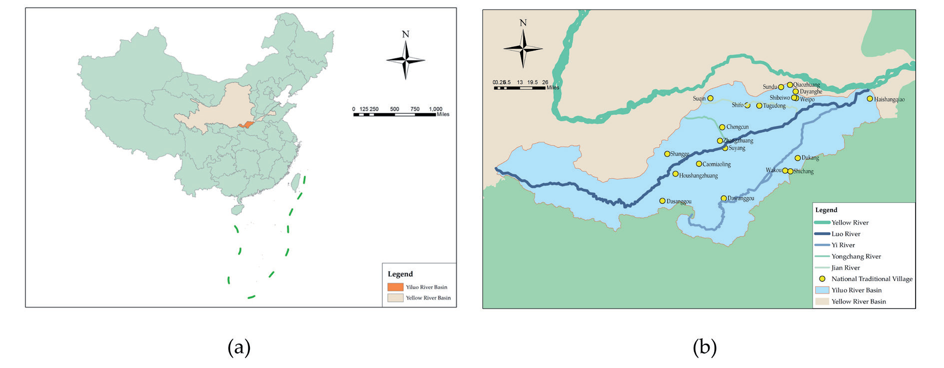
Fig. 3.
Virtual line segments in traditional village boundaries. a) is an illustration of the virtual line segments in the boundary, b) is an illustration of the different village boundaries formed by the different accuracies of the virtual line segments.
Step 1: Generate the Delaunay triangulation of the spatial point set D;
Step 2: Delete the longest outside edge from these triangles according to the following principle: the deleted edge should be longer than the parameter l, and the outside edge of the triangle should still form a complete outline;
Step 3: Repeat step 2 and continue to remove more edges;
Step 4: Return one polygon at a time.
This paper uses the village building turning points as the spatial points D and the length of the virtual line segment as the control parameter l for village boundary delineation. In addition, the length of the virtual line segment was designed using the longest and shortest line segments of the convex hull of the village, and interpolation was performed to determine the length of each virtual line segment. The greater the number of interpolated virtual line segments of village boundaries, the higher the accuracy of village boundaries, and the greater the number. This design method has two advantages. First, the length of virtual line segments is not mechanical but designed according to each village’s own situation, which is specific. Second, the number of interpolated values can be changed as needed to control the accuracy of the boundary.
Method for Assessing the Optimal Boundary of a Village
Villages have grown organically without much outer planning [16, 39-41]. It is a physical reflection of the villagers’ rational organization of their production and lives. However, the addition of many non-village functions has changed their original production and life order. The physical space then changes, and the further away from the village center, the faster this change occurs, so that the boundary of the village changes. From this viewpoint, this paper constructs an evaluation system of village boundaries in terms of the convenience of villagers’ activities (the problem of efficiency) and villagers’ habitual use of village space (a large amount of blank space) to find the optimal boundary of the village [32]. This paper used two indicators, emptiness and complexity, to measure blank space within the village and the efficiency of village boundary use. The blank space is mainly reflected by the value of emptiness, and the smaller the value, it means that the space formed inside the boundary is more in line with the villagers’ habitual use. The efficiency value is mainly reflected by the value of complexity, and the smaller the value, the higher the efficiency. Thus, when the values of emptiness and complexity are all minimized, this paper suggests that this represents the most optimal boundary. However, these two indicators show an inverse relationship, i.e., there is a large amount of blank space in the village when efficiency is at its highest. This paper calculates the minimum value of a fitness function. The fitness function, emptiness model, and complexity model are described below.
Fitness Function
For a set of spatial points set D, the process of generating an external polygon is either the polygon covers the largest area and has the smallest perimeter, the fewest number of sides, and the smoothest shape, or it generates a polygon for the opposite case. Akdag et al. proposed a fitness function that is able to fit polygon P to the set of spatial points D, generating smooth polygons with low emptiness and low complexity with respect to D [42]. They defined this fitting method as follows:
where emptiness (P, D) is the emptiness of the fitted polygon P of the spatial point set D; complexity (P, D) is the complexity of the fitted polygon P of the spatial point set D. C is the parameter that balances the weights of emptiness (P, D) and complexity (P, D). Its value is taken as [0,1]. The larger the value of C, the smoother the polygon. This paper sets C to 1 to find smooth polygons. This paper describes the complexity (P, D) and emptiness (P, D) models below.
Emptiness Model
Akdag et al. developed the emptiness model [42], which assesses the emptiness of a polygon P with respect to a spatial point set D, as follows:
where Pconv is the convex hull of point set D; DT (D) is the Delaunay triangle network of point set D; θ is the threshold value for determining whether a triangle is empty; t is a triangle whose area is potentially smaller than the threshold θ.
Complexity Model
Brinkhoff et al. developed the model for measuring polygonal complexity [43]. The model contains three parameters, ampl, freq, and conv, and is formally defined as follows:
where ampl (P) is the vibration amplitude of the polygonal vertices; Freq (P) is the vibration frequency of the polygonal vertices; Conv (P) is the convexity of the polygon; Boundary (P) is the length of the polygon; Notches (P) is the number of concave points in the polygon; Vertices (P) is the number of vertices in the polygon; Area (Pconv) is the area of the polygon Pconv; notchesnorm (P) is normalized to the number of notches.
In Equations (2)–(7), the boundary of a traditional village is polygon p. The vertices of the traditional village building outlines are the spatial point set D.
Method of Classifying the Type of External Spatial Form of Villages
The boundary is the decisive element in the type of external spatial form of villages. Excessive changes in the boundary form will affect the type of external spatial form of villages and indicate the destruction of the interdependence between villages and their surrounding natural environment. There are clear provisions in the Traditional Village Evaluation and Recognition Index System issued by China. Therefore, when delineating multiple boundaries of villages, it is important to focus on the type of external spatial form of villages. Then, classifying the type of external spatial form of the village is an important issue this paper should solve. This paper uses cluster and band as the types of external spatial forms of villages [44]. This paper used the Minimum Area Bounding Rectangle (MABR) method to obtain the lengths of the long and short axes for villages and used their ratios as classification criteria. The specific methodology is as follows:
Step 1: Calculate the maximum and minimum values of the coordinates of the building distribution within the village to obtain the external rectangle. Get the smallest rectangle and assign it to RectMin, assign the area of the rectangle to AreaMin, and set the rotation angle α = 0°;
Step 2: Rotate the outline of the village building by an angle θ. According to step1, find the smallest rectangle RectTmp after rotation and record its area as AreaTmp;
Step 3: Set the rotation angle α = α + θ, compare the size of AreaTmp and AreaMin, assign the value of the small area to AreaMin, and assign the rotation angle to β = α at this time, and rectangular information to RectMin = RectTmp;
Step 4: Loop through the processes of steps 2 and 3, and finally obtain a minimum external rectangle RectMin and the corresponding rotation angle α;
Step 5: Rotate the calculated rectangle RectMin by a β angle in the reverse direction to obtain the smallest external rectangle.
The paper begins by delineating multiple boundaries for the village and evaluating these boundaries to find the length (l) of the virtual line segment corresponding to the optimal boundary. Then, the village spatial form is categorized to obtain the aspect ratio (λ). Finally, the type of spatial form (λ) and the length of the virtual line segment (l) of the optimal boundary of the village are mathematically modeled to find the range of the optimal boundary without affecting the spatial pattern type. Multiple village boundaries within this range are reasonable for village conservation and development. This paper validates the usability of this strategy by examining 20 empirical subjects.
Results and Discussion
Delineation of Traditional Village Multiple Boundaries by the Chi-Shape Algorithm
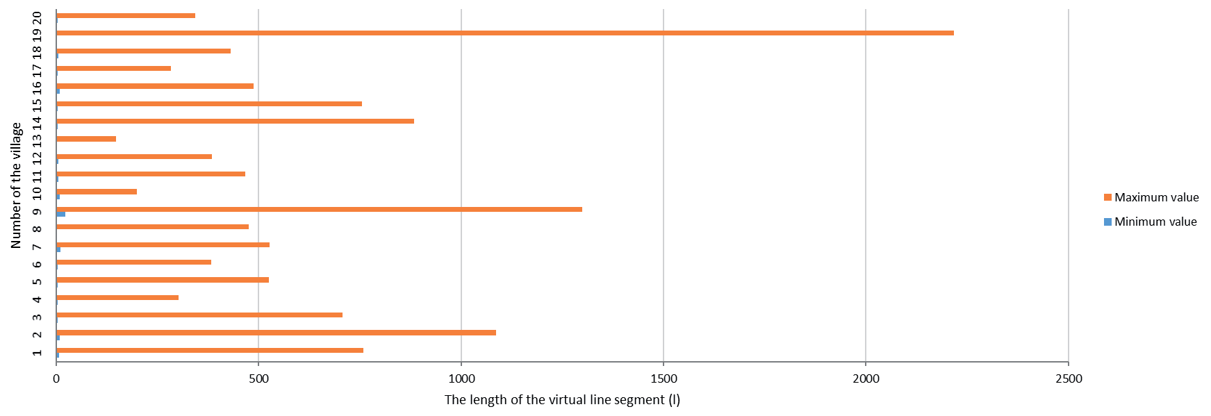
This paper delineated multiple traditional village boundaries in the Yiluo River Basin. This paper designed 100 virtual line segment lengths for each village to delineate 100 village boundaries. These lengths are used as the values of parameter l of the chi-shape algorithm to perform iterative operations to delineate a boundary. Each village boundary is numbered sequentially from small to large according to the length of the virtual line segment, denoted by χ. Fig. 4 is the histogram of the length of the virtual line segment for 20 traditional villages. There are significant differences in the range of values for the different villages. The maximum values were taken from 2216.68-148.50 m and the minimum values were taken from 22.39-2.38 m. A total of 13 villages have values below 550 m, while the remaining seven are above 700 m. The maximum value of the standard deviation is 648.75 m, the minimum value is 42.82 m, and 17 villages have values below 258.06 m.
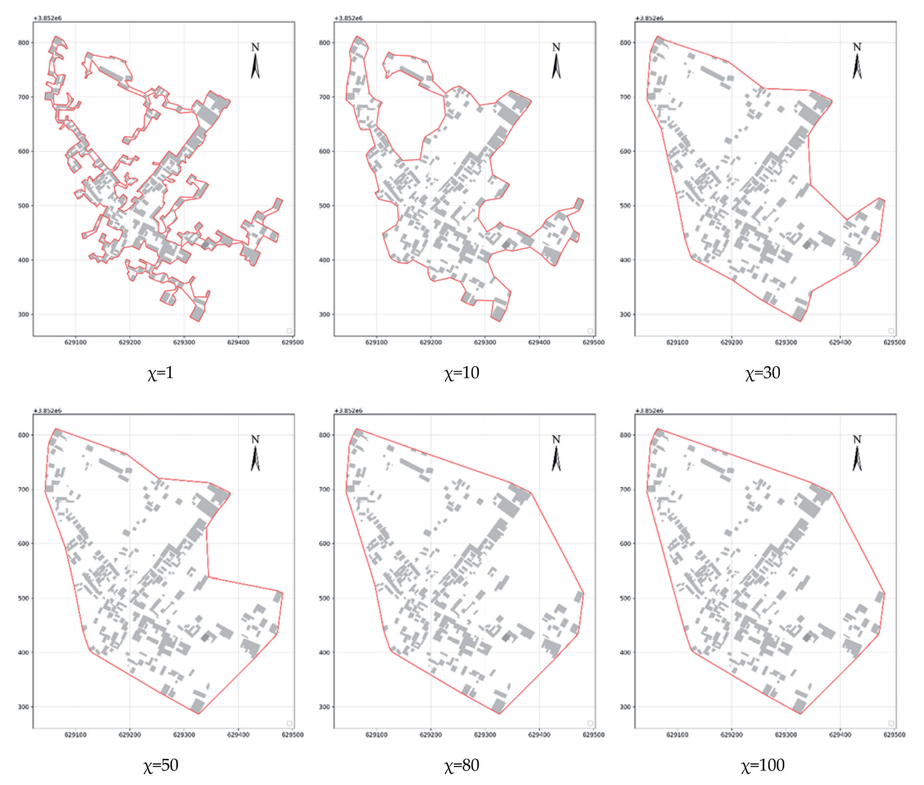
Fig. 5 demonstrates the boundary cases of Dayanghe Village, with virtual line segments (l) taking lengths of 3.56 m, 30.68 m, 90.94 m, 151.20 m, 241.59 m, and 301.85 m, corresponding to the serial numbers (χ) 1,10,30,50,80,100, respectively. We can see from the figure: When χ = 1, the village boundary is delineated close to the building edges and is very concave and convex, and much of the space between the outer buildings of the village is excluded from the boundary. When χ = 10, the length of the virtual line segment for the village boundary increases, the number of areas between the outer structures of the village that are delineated into the village boundary increases, and the boundary becomes smooth. When χ=30,50,80,100, the length of the virtual line segment for the village boundary continues to increase, the number of turns wrapping the same number of buildings continues to decrease, and the number of areas between the outer structures of the village that are delineated into the village boundary continues to increase. Finally, the village boundaries become a convex hull of village buildings, very smooth and with maximum internal space. It shows that the number of buildings spanned by each boundary segment increases as the length of the virtual line segment increases. It indicates that the value of l represents the ability of the boundary to span buildings. The larger the l value, the stronger the spanning capacity. As such, the boundaries of villages become smoother. In this case, this paper used this method to delineate 100 boundaries for each of the 20 traditional villages, for a total of 2,000 boundaries.
Selection of the Lengths of the Virtual Line Segment for Optimal Boundaries by Fitness Function
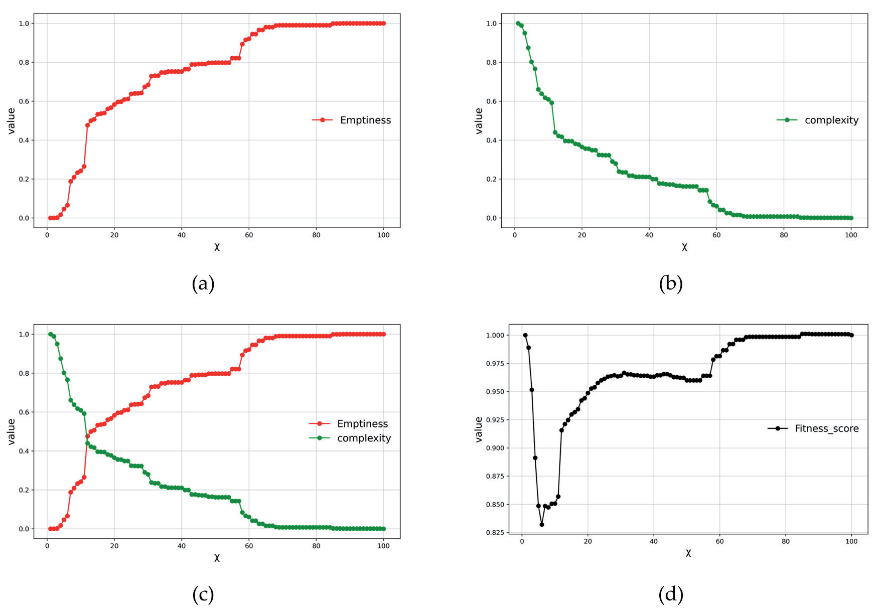
This paper selected the optimal boundaries of traditional villages in the Yiluo River Basin and determined the length of their virtual line segments. The following is an example of Dayanghe Village with its 100 boundaries evaluated. Emptiness is positively correlated with the length of the virtual line segment (Fig. 6a), or emptiness increases with the l value of the virtual line segment. Conversely, complexity is negatively correlated with the length of the virtual line segments (Fig. 6b), and complexity decreases as the l value of virtual line segments increases. These two indicators, emptiness and complexity, demonstrate opposite trends, and the value of complexity is decreasing when the value of emptiness increases (Fig. 6c). Using the fitness function, the overlay is calculated based on the contributions of the two indicators. The fitness curve decreases and then increases as the length of the virtual line segment increases, when χ = 5, the fitness function value is the smallest, at 0.83 (Fig. 6d). Therefore, when χ = 5, the boundary is the optimal boundary, when the length of the virtual line segment takes the value of 18.63 m. That is, it is shown in Fig. 7.
This paper uses this system to evaluate 2,000 boundaries of 20 traditional villages and select 20 optimal boundaries (Fig. 8). In the figure, the red line indicates the optimal village boundary, and the χ value is the serial number corresponding to the optimal boundary of each traditional village. The l value is the length of the virtual line segment (the original value) of the traditional village.
From the results, this paper can deduce that: When the length of the virtual line segment takes smaller values, the village boundaries are delineated precisely, which meets the requirement of villagers’ habitual use of village space, yet does not meet the requirement of the convenience of villagers’ activities; when the value of the length of the virtual line segment increases gradually, the village boundary becomes smoother, which meets the convenience of villagers’ activities, but does not meet the requirement of villagers’ habitual use of village space. Therefore, finding the boundary that meets both high habitual and high convenience requirements is the range that meets the villagers’ production and life, and this boundary is the optimal boundary.
Classification of External Spatial Forms for Traditional Villages by Minimum Area Bounding Rectangle
This paper classifies the external spatial forms of traditional villages according to their narrowness. The ratio of the long axis to the short axis of a village describes its narrowness, i.e., the intensity of the band-like characteristic. This paper determined the minimum rotated external rectangle of each traditional village boundary and calculated its aspect ratio. This paper then used the aspect ratio as a basis for classifying the external spatial form of traditional villages. This paper classified a ratio greater than 2 as a band form, a ratio less than 2 as a cluster form, and a ratio between 1.5 and 2 as a cluster form with a band tendency. This paper applied the minimum_rotated_rectangle algorithm in the Shapely package using Python to generate the minimum number of rotated external rectangles. λ is the rectangle’s aspect ratio. Table 1 shows that among the 20 traditional villages in the Yiluo River Basin, 7 are cluster villages (35%), 5 are cluster villages with a band tendency (25%), and 8 are band villages (40%).
Fig. 6.
Normalized curves for finding optimal chi value using the fitness function. a) Emptiness, b) complexity, c) emptiness, and complexity curves overlaid, and d) fitness score of Dayanghe Village boundaries.
Here, this paper classifies the external spatial form of traditional villages in order to further explore the relationships between the type of external spatial form of villages and the length of the virtual line segment of optimal boundaries.
Constructing the Mathematical and Theoretical Relationship between the Types of External Spatial Forms and the Length of the Virtual Line Segment
of Optimal Boundary for Traditional Villages.
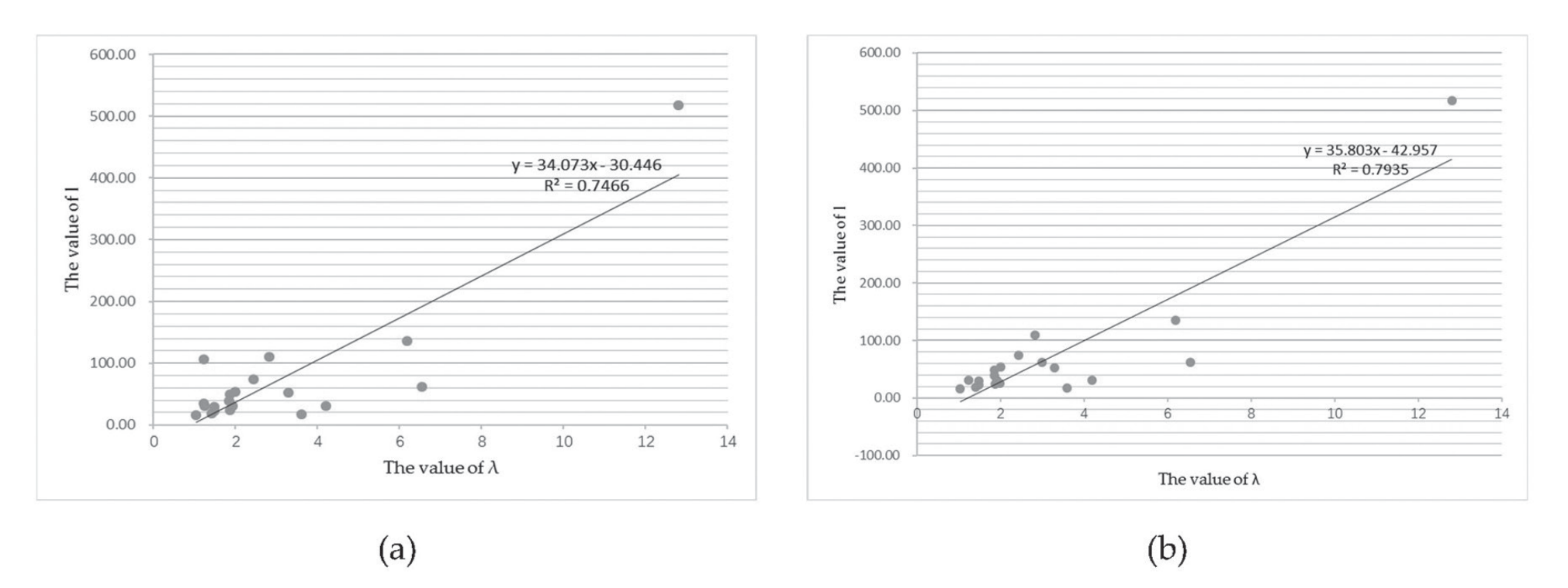
The type of external spatial form of traditional villages is expressed by the ratio of the length and short axis of the minimum rotated external rectangle of the village, λ, and the length of the virtual line segment for the optimal boundary is expressed by l. This paper carried out a regression analysis of the two values, which indicated that the slope of the regression line is positive and the value of l increases with the increase of the λ value (Fig. 9a). As seen in Table 2, the value of l for the optimal boundary is about 15.67-30.77 m when the village λ value is in the range of 1-1.5, i.e., when the village is in cluster form. When the village λ value is in the range of 1.5-2.0, i.e., when the village is a cluster form with band tendency, the l value of the optimal boundary is approximately 31.34-53.56 m. When the village λ value is above 2.0, i.e., when the village is a band form, the l value of the optimal boundary is approximately 52.09 m or more. However, Weipo Village and Suqin Village have more sporadic buildings present outside the main building complex, which affects the overall mathematical and theoretical relationship. Therefore, this paper removes the outlying buildings and modifies the data relationships for these two villages. The regression trend of the modified results is more visible (Fig. 9b). The λ-l mathematical and theoretical relationship indicates that the length of the virtual line segment of the optimal boundary for villages with different types of external spatial forms takes different ranges. The higher the degree of banding of the external spatial forms of traditional villages, the larger the length of the virtual line segment of the optimal boundary.
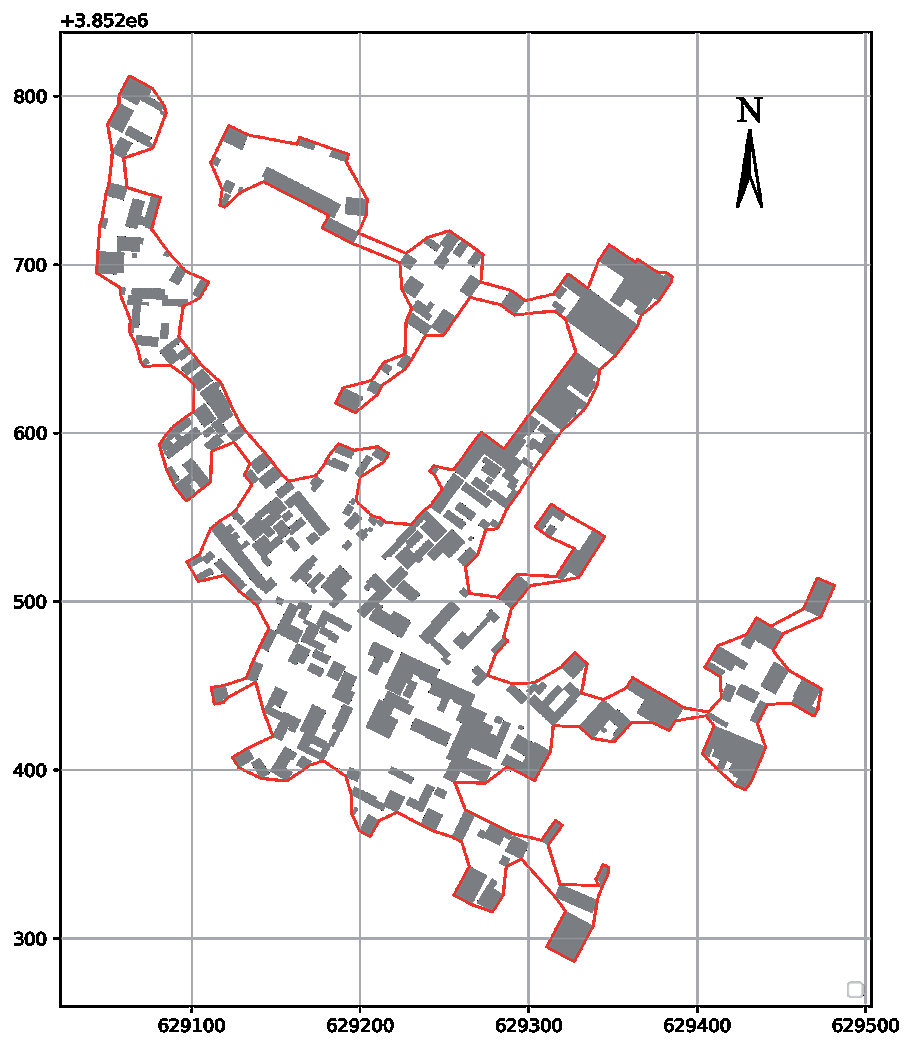
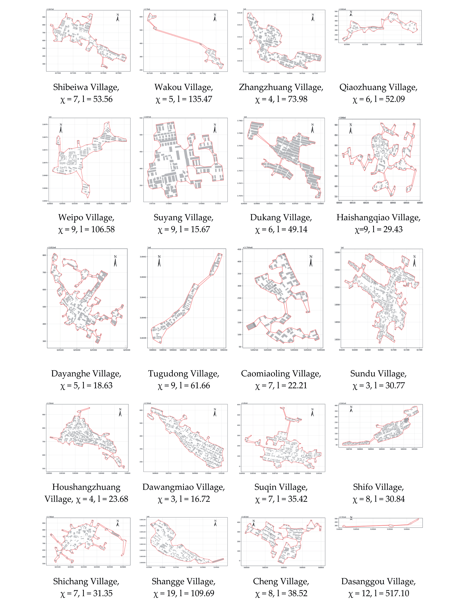
Table 1.
Classification of external spatial forms of traditional villages in the Yiluo River Basin.
The Relationships between the Type of External Spatial Forms of Villages and the External Environment
The higher the degree of banding in the external spatial form of villages, the more influenced they are by the natural environment. The degree of agglomeration in the distribution of structures in villages is relatively high, which is expressed as the degree of separation between buildings. In the boundary iteration algorithm, this is expressed as the length of the virtual line segment of the optimal boundary. The larger the length, the lower the degree of agglomeration. The length of the virtual line segment of the optimal boundary gradually increases with the increase of village banding, which means that the degree of village agglomeration decreases and further indicates that the village is being hindered in its “growth,” which is actually influenced by the natural environment (Fig. 9). From this perspective, villages with a band form have been more influenced by the external natural environment in the formation.
Delineation of Boundaries that Meet the Needs of Village Conservation and Development
As shown in Table 2, the critical nodes for taking the length of the virtual line segment of the optimal village boundary are 15 m, 30 m, 50 m, and 130 m, which are consistent with the conclusions of Pu [22] and Lu [23]. Village participants can apply the multiple boundary delineation algorithm to delineate multiple village boundaries based on the mathematical relationship of λ-l, taking the threshold value of l as a control parameter. Finally, a suitable boundary is selected in combination with the project demand, which is the optimal boundary of the village. For example, among the traditional villages in the Yiluo River Basin, Suyang Village belongs to the cluster spatial pattern (1.0<λ<=1.5), which corresponds to a virtual line segment length threshold of 15-30 and five boundaries are delineated by applying the multi-boundary delineation algorithm, which are used as the boundaries to be selected in combination with the project. This method provides multiple reasonable boundaries for the project. These boundaries serve to protect the external spatial form type of the village without losing opportunities for village development. This strategy achieves the goals of both village conservation and development.
Table 2.
Comparisons of classification of the traditional village external spatial form - the length of the virtual line segments of optimal boundaries’ mathematical and theoretical relationship.
Conclusions
In this paper, to solve the problem that a single village boundary cannot cope with the needs of village conservation and development, this study proposes a strategy of multiple boundary delineation for villages. This strategy can not only not change the original spatial form type of the village, but also meet the flexible needs of the village development on the boundary. First, the paper resolved that virtual line segments were the decisive elements constituting village boundaries; then, the study used the length of village virtual line segments as a parameter and used the chi-shape algorithm to delineate the boundaries for villages; then, the study classified the type of external spatial form of the village; finally, the study constructed a mathematical and theoretical relationship between the length of virtual line segments and the type of village external spatial form for the optimal village boundaries and found a reasonable control parameter (length of virtual line segments) for the delineation of multiple boundaries for villages. From this relationship, the optimal virtual line segment length range corresponding to the village’s external spatial form type is found, i.e., the reasonable control parameter range (virtual line segment length). Village boundaries delineated within this range will not change the type of external spatial form of the village.
This paper concludes as follows: (1) the external spatial form types of villages show a segmental distribution pattern corresponding to the virtual line segments of the optimal boundaries; (2) the higher the degree of banding for the external spatial form of villages, the higher the length of the virtual line segments of the optimal boundary; (3) the length of the virtual line segment of the optimal boundary for traditional villages with cluster form is 15.66-30.77 meters; the length of the virtual line segment of the optimal boundary for traditional villages with the cluster form with band tendency is 31.34-53.56 meters; the length of the virtual line segment of the optimal boundary for traditional villages with the banded form is 53.56 meters or more; (4) villages with a band form have been more influenced by the external natural environment in the process of formation.
This study has produced a quantitative range of optimal boundary virtual line segment lengths corresponding to the three external spatial form types. This range is specifically: the parameter range of multi-boundary delineation for villages with clustered spatial form type is 15-30, the reasonable parameter for villages with banded tendency clustered spatial form type to delineate multi-boundary is 30-50, and the parameter range of multi-boundary delineation for villages with banded spatial form type is 50-130. Delineating the boundary within this parameter achieves the goal of not changing the spatial form type of the village while still accommodating its development. This strategy balances the relationship between the protection and development of the village and plays a positive role in promoting the healthy growth of the village. It has important theoretical and practical significance for the protection and development of villages.
The limitations and potential improvements of this study are twofold. One aspect is to increase the number of traditional villages studied. The conclusions drawn from the study design are based on 20 traditional villages in the Yiluo River Basin. Although the results are compelling, it would enhance the persuasiveness of the framework if the number of sample villages could be increased to include provincial traditional villages. Another option would be to increase the types of external spatial forms of villages. The study adopted a dichotomous approach to the types of external spatial forms of villages to make the process clearer and the conclusions more concise. More mathematical and rational classification methods that can express the external spatial forms of villages should be used in subsequent studies to increase the number of types of external spatial forms of villages, refine the classification, and discover more complex relationships between external spatial forms and boundaries.

