

Introduction
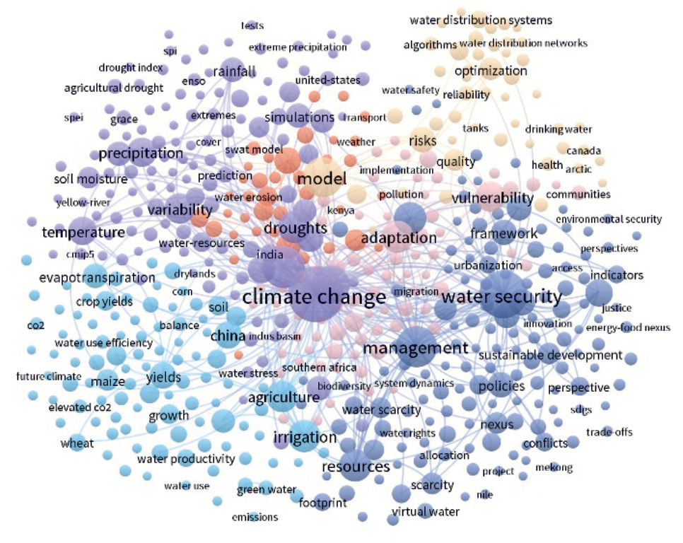
The word "water security" was first proposed at the Water Forum conference in 2000, which usually refers to the water-related disasters that occur in the course of human social survival and economic development [1]. It is a concept that involves the interaction of water resources security, engineering security, water disaster, and water ecological environment security. [2-5]. Nowadays, there is an increasing amount of research on water security, and 3920 papers on "water security" published in the past 20 years were searched and screened from the core database of Web of Science (WOS), and the keywords were mapped using the VOS viewer. (Fig. 1). It can be seen that the discussion on water security focuses on the construction of a regional water security evaluation index system model in the context of climate change. By determining the weight, assignment, and classification level, the advantages and disadvantages of the overall regional water security situation and the level of water security guarantee ability and risk are directly and macroscopically determined. [6, 7]. Few studies have analyzed the specific regional water security issues region. However, due to the more complexity and greater uncertainty of many factors affecting regional water security, it is necessary to strengthen the accurate diagnosis of regional water security problems and clarify the causes, evolution characteristics, and development trend of each problem, which is conducive to the adoption of adaptive measures for water resources management in the context of climate change.
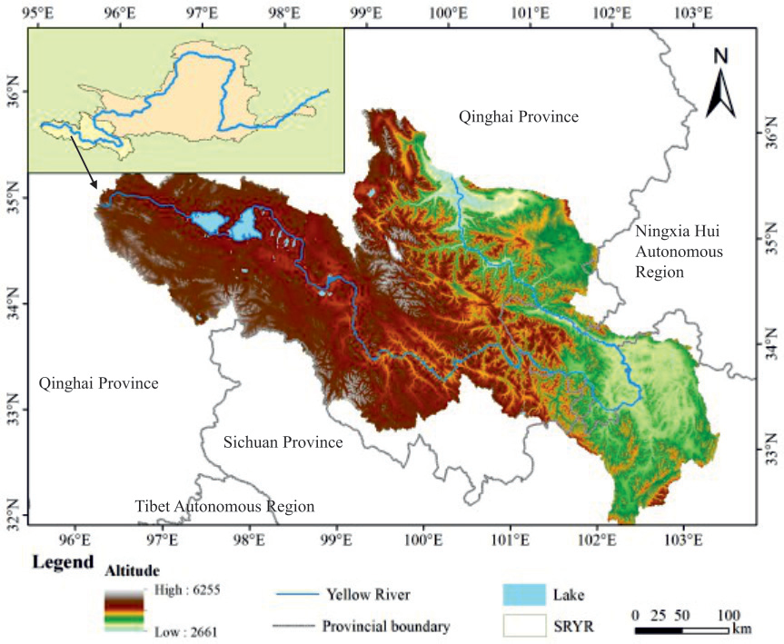
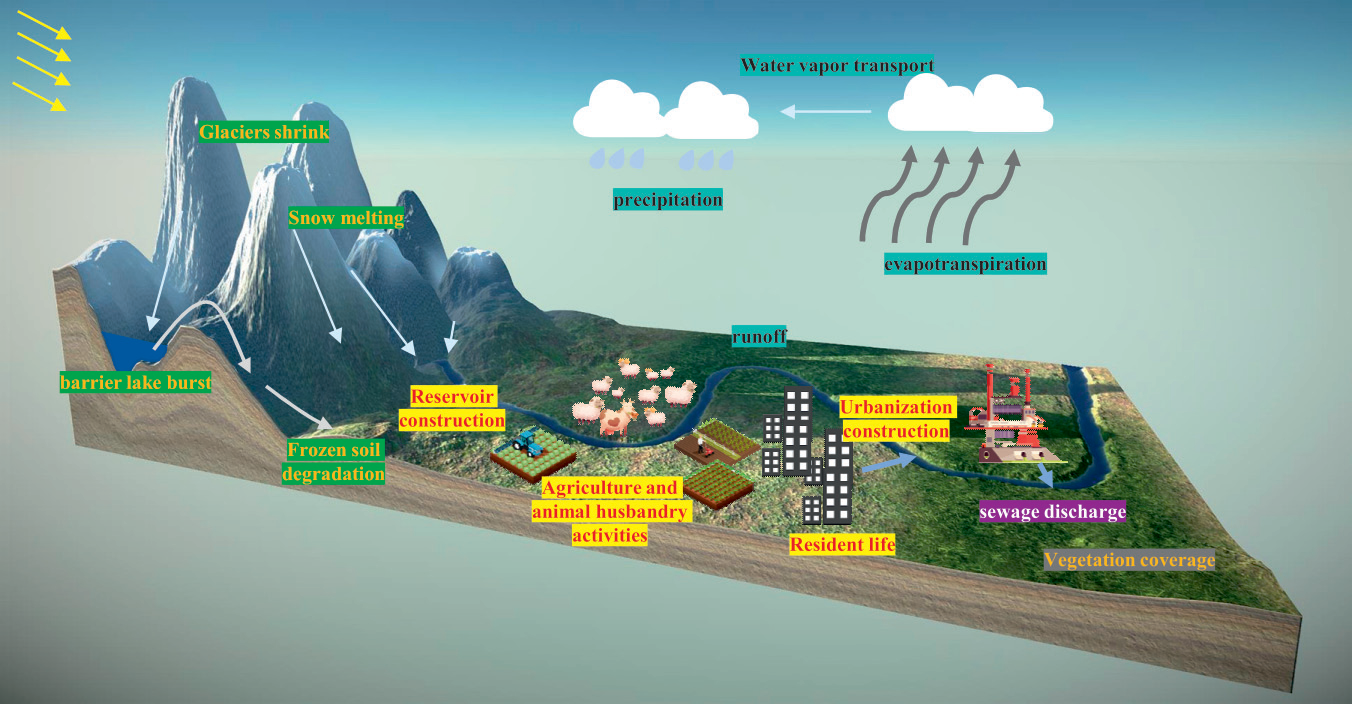
The Three-River Source Region (TRSR), located in the hinterland of the Qinghai-Tibet Plateau (QTP), is not only an important eco-safety barrier for China but also a "fragile area" for the ecological environment in Asia and a "sensitive area" for global climate change [8, 9]. The SRYR is an important part of the TRSR, geographic location between 95°E~104°E and 32°N~37°N (Fig. 2), its drainage area of about 12.2×10⁴ km2, less than 1/6 of the total area of the Yellow River Basin (YRB), but contributed more than 1/3 of the water resources in the basin, is the main water producing area of the Yellow River (YR) [10]. In recent years, climate change, mainly characterized by warming, has significantly impacted water resources and water ecosystems in the SRYR, generally in terms of declining runoff [11], permafrost degradation [12], glacier retreat [13], snow melt, and changes in the lake area [14], etc. Under the scenario of continued climate change in the future, the succession of water resources and water ecosystems in the SRYR will induce a series of potential water security problems, which will directly affect the stability and development of the local and the middle and lower reaches of the YRB, and affect the hydrological evolution of the entire YRB and even the QTP (Fig. 3). Based on the coverage of water security, existing studies have achieved remarkable results in drought and flood disasters and water ecological degradation in the SRYR [15-17], but there is a lack of systematic review of water security problems and their evolution characteristics in the region.
Therefore, on the basis of comprehensive induction and systematic summary of relevant research results, this paper accurately diagnosed the key water security problems in the SRYR, identified the evolution characteristics of each, and analyzed the synergistic cascade effect between different cruxes in the three aspects of water supply security, water disaster prevention and water ecological damage. It is of great practical significance to deal with the water security problems and their impacts and crises in the SRYR under the background of climate change, and to make timely adaptive measures to defend and respond to risks.
Data and Methods
Data
On the basis of previous research results, this paper also uses flood and drought disaster data, water resources data and ecological environment data. The flood and drought disaster data are from the "China Flood and Drought Bulletin" published by China Water Resources and Hydropower Press from 2006 to 2021. The water resources data involve the "Yellow River Water Resources Bulletin" published by the Yellow River Water Resources Commission of the Ministry of Water Resources of China (yrcc.gov.cn) from 2001 to 2021 and the "Qinghai Water Resources Bulletin" published by the Qinghai Water Resources Information Network (qinghai.gov.cn) from 2010 to 2021. The ecological environment status data includes the "2021 China Ecological Environment Status Bulletin" issued by the Ministry of Ecological Environment of China (mee.gov.cn) and the "2021 Qinghai Ecological Environment Status Bulletin" issued by the Qinghai Provincial Department of Ecological Environment (qinghai.gov.cn).
Methods
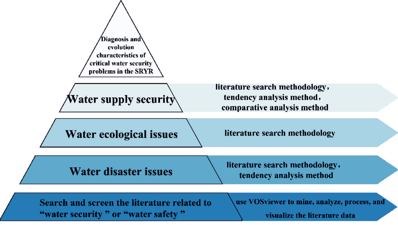
In order to systematically diagnose the key water security problems in the SRYR and clarify its evolution characteristics, we used a combination of various research methods (Fig. 4). Firstly, the VOSviewer [18] is used to mine the literature data related to "water security" in the core database of Web of Science (WOS), and the keywords are screened for relationship construction and visual analysis. On this basis, it is determined that the scope of water security includes water disasters, water ecological security and water supply security. The main method used is the literature research method [19], through the collection and collation of relevant literature, a comprehensive and objective understanding of each issue is formed ; at the same time, the trend analysis method and comparative analysis method are used to quantitatively analyze the social and economic effects of regional water disasters and the severity and urgency of the problems in water supply security.
Diagnosis and Evolution Characteristics of Critical Water Security Problems in the SRYR
Water Disasters Issues
Evolution Characteristics and Situation of Drought and Flood Disasters
Water disasters are the most direct manifestation of regional water security problems and one of the critical factors limiting regional socio-economic development. It mainly includes the risks caused by the shortage or excess of regional water resources, namely, drought and flood [20]. Due to its complex geographical and geological structure and changeable climatic conditions, the SRYR has naturally formed a unique disaster-pregnant environment, resulting in frequent natural disasters. According to the existing research results [21, 22], it seems that, the SRYR has experienced the evolution process of frequent drought events-indirect occurrence of drought events-coexistence of drought and flood events in the past 60 years, and the change of the region from dry to wet gradually occurred from the end of the 20th century to the beginning of the 21st century.
Drought Disaster
Synthesizing the previous studies on drought, we usually start with meteorological drought caused by precipitation reduction and its induced hydrological drought, agricultural drought, and socio-economic drought [23], that is, we can judge whether there is a drought event and its degree from the amount of precipitation and runoff. In quantifying drought intensity to analyze the extent of its impact on the region and risk control, scientists have proposed and defined numerous drought indices, such as the Standardized Precipitation Index (SPI) [24], the Standardized Precipitation Evapotranspiration Index (SPEI) [18], the Palmer Drought Severity Index (PDSI) [25], the Standardized Runoff Index (SRI) [26]. These drought indexes can reflect the correlation, spatial and temporal distribution, and transmission relationship among different types of droughts in the region to a certain extent, and are widely used in studies to explore the trends and characteristics of dry and wet changes in the SRYR [27, 28].
Based on many research results [15, 29-34], we have sorted out and analyzed the drought situation in the SRYR from two dimensions: spatial distribution and temporal evolution of drought degree. In terms of spatial distribution, the evolution of drought shows a trend of shifting from south to east. Taking 1993 as the boundary, the drought center in the source region of the Yellow River has experienced a transfer process from the south to the east of the region. The drought degree has changed from severe drought in the south, mild drought in the east to relatively severe drought events in the east. From the temporal perspective, there is a tendency for the regional drought to lessen, and from the end of the 20th century to the beginning of the 21st century, the SPEI decreased sharply and then showed an upward trend, and the region is still in a mild drought state, and the drought situation is still not optimistic.
The phenomenon of drought evolution is a direct reflection of the spatial distribution and interannual variation pattern of regional precipitation and runoff. Sub-regional studies show that the spatial characteristics of precipitation during 1956-2005 are increased precipitation in the west and decreased precipitation in the east [35], so the trend of drought in the east is enhanced and the frequency of extreme drought events is significantly increased [36]. In the study of interannual variation, the precipitation in the SRYR from 1956 to 2018 showed the characteristics of decreasing first and then increasing. The decrease in precipitation leads to a reduction in the direct recharge source of regional water resources, which further contributes to the occurrence and succession of drought events, forming a disaster chain effect, such as triggering fires, wind and sand disasters, pests, epidemics, and other disasters. More seriously, the SRYR, as an important water-producing area in the YRB, will have irreversible effects on life and production in the middle and lower reaches of the river in the event of a drought in the region and a decrease in water production.
Flood Disaster
The evolution of the climate toward warming and humidification in the SRYR has expanded the forms of disaster occurrence in the SRYR and intensified the possibility of flooding in the area. It has become an indisputable fact that global climate change is characterized by rapid warming. The sixth report of the Intergovernmental Panel on Climate Change (IPCC) pointed out that the global average temperature from 2010 to 2019 was 1.07ºC higher than that from 1850 to 1990 [37], Different sequence data show that large-scale warming also occurs in the source region of the SRYR [38-40]. In addition, since the 1960s, the precipitation in the SRYR has gradually increased, with an average annual precipitation increase of nearly 27% [16]. Particularly, in the 21st century, the climate wetting in the SRYR accelerated [41-43]. The average precipitation in 2001-2019 increased by 29.8 mm compared with that in 1961-2000 [39, 44, 45].
The evolution of climate warming and humidification enhances the melting effect of glacier snow in high latitudes or high altitudes. Seasonal snowmelt water affects the change in the lake area and water quantity [46]. The characteristics of delayed start date and advanced end date of snow accumulation, shortened snow cover, and reduced snow cover days in the SRYR have promoted the physical process of snow sublimation and melting to a certain extent and changed the seasonal variation trend of snowmelt runoff [47], leading to flooding in the area in addition to the rainstorms and floods caused by typical precipitation processes, the possibility of snowmelt-ice type floods is also increasing, which in turn increases the risk of secondary disasters such as flash floods and mudslides [48].
From the perspective of geological conditions, the SRYR is located in the QTP, which belongs to the alpine plateau area. The western of the SRYR carries Gyaring Lake and Ngoring Lake, and the eastern margin has Anyemaqen Mountains. It is a region with rich and dense distribution of lakes, glaciers, and permafrost. The glaciers in the Anyemaqen Mountains are developed. Although the number of modern glaciers in the mountainous area and its surroundings has a slight increasing trend, the area shows a decreasing trend, and the shrinkage rate of glacier area is nearly 20%. [49]. Some studies have found that from 1966 to 2013, glaciers have been showing a state of accelerated retreat, and the coverage of glacier moraine has an increasing trend [50, 51]. When glacier activity is intense, it usually breaks away from the ice body in the form of an ice avalanche, ice-rock avalanche, and glacier collapse or glacier detachment, jumps over the surface moraine, and falls into the glacial lake, triggering a dammed lake outburst flood. It is worth noting that the Xiaomagou glacier in Anyemaqen Mountain experienced four consecutive glacier collapse events in 2004, 2007, 2016, and 2019 [52], which has become a new form of glacier disaster in recent years, and the instability of the glacier has the possibility of continuous collapse to a certain extent, which brings about some potential glacier disasters [53].
In the future, according to the prediction results of drought and flood characteristics in the YRB by Zhang et al. [54]. it is speculated that the probability, frequency, intensity, and coverage of wet events in the SRYR are greater than those of drought events, and at the same time, it is prone to alternating floods and droughts. Especially under the background of climate change, the increase in temperature leads to the change in the way and speed of atmospheric circulation and water circulation, and the basin is easy to form precipitation, which leads to the simultaneous spatial and temporal variation of precipitation and warming and aggravates the occurrence of flood events.
Socio-Economic Effects of Water Disasters
From the perspective of the water resources system, drought means the socioeconomic effect caused by the increase in a water shortage. The cause of the flood disaster is due to the excessive amount of water in the region, which can not rely on the water conservancy project and the natural water cycle process to regulate and regulate, and then cause damage to the regional environment, human life, industrial and agricultural production, and social order. Because most of the SRYR is located in Qinghai Province (QHP), this paper reflects the adverse socio-economic effects of drought and flood disasters in the area through six indicators in QHP: the Crop Area Affected by Drought (CAAD), the Rural Population with Difficulty in Drinking Water due to Drought (RPDDWD), and the Rural Large Livestock with Difficulty in Drinking Water due to Drought (RLLDDWD), the Population Affected by floods (PAF), the Direct Economic Losses due to Floods (DELF), and the Crop Area Affected by Floods (CAAF).
Fig. 5.
Drought and flood disasters in 2006-2021 (Note: According to the statistics of Qinghai Province).
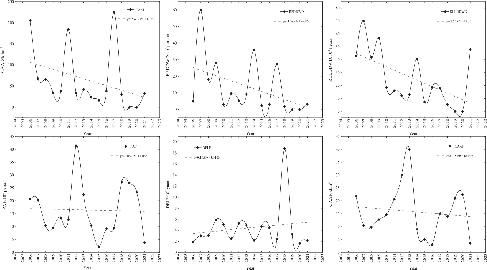
According to the statistics of the "China Flood and Drought Bulletin" from 2006 to 2021 (Fig. 5), drought and flood disasters with different degrees of disaster-causing occur every year in the region. The three indicators of the CAAD, the RPDDWD, and the RLLDDWD decreased at a rate of 5.49 k hm2/a, 1.6×10⁴ person/a, and 2.56×10⁴ heads/a, respectively, indicating that the disaster losses caused by drought in the region have slowed down in recent years. Among them, the index of the drought-affected area of crops has changed from valley-peak-valley in a five-year cycle in the past 16 years. Although the three indicators all showed a brief drought-free situation in 2019, there has been a clear upward trend in the past two years, which does not mean that the impact of drought on human and animal life has disappeared, indicating that attention should still be paid to the risk of potential drought in recent years, and its disastrous consequences should not be underestimated.
Although the PAF and the CAAF decreased at a rate of 0.07×10⁴ person/a and 0.26 k hm2/a, respectively, the DELF still showed an increasing trend at a rate of 0.14×10⁸ yuan/year. Besides, from the perspective of the fluctuation degree of each index in Fig. 5, the inter-annual fluctuations of various disasters and losses caused by floods are large, the fluctuations are violent and unstable, and there is no obvious periodicity. In this way, it is difficult to predict and determine the time of flood disasters and the severity of losses. Therefore, in the future, the trend that floods events account for the main position of flood and drought disasters not only aggravates the uncontrollability of flood disasters but also puts forward higher requirements for long-term dynamic monitoring and strengthening the "four pre-measures".
Water Ecological Issues
Grassland Degradation
The unique geographical environment and climatic conditions make the TRSR one of the most sensitive and fragile ecosystems in China [55]. Grassland is the most important ecosystem type in this region and alpine grassland accounts for more than 70% of the land types in the SRYR [56]. However, climate change and human activities have impacted the fragile links of the ecosystem in the SRYR, threatened the integrity of the ecosystem, and caused different degrees of degradation of alpine grassland [57, 58]. The decrease of grassland coverage and the significant baldness lead to soil erosion, loss of ecological function, and the formation of a unique ecological deterioration phenomenon "black soil beach".
Based on the existing research results, grassland degradation in the SRYR has significant stage and regional characteristics [59]. The degradation phenomenon mainly occurred from the 1970s to the beginning of the 21st century. The grassland degradation area accounted for more than 1/3 of the total grassland area, of which the heavily degraded grassland accounted for 26.79% of the grassland area. The grassland degradation in the west of the region was the most typical [60], such as Maduo County, Qumalai County, Dari County, Maqin County, and Zhiduo County, while the degradation degree in Xinghai County, Zeku County, and Tongde County in the east of the SRYR was relatively weak and in a state of mild degradation [61]. Based on regional Normalized Difference Vegetation Index (NDVI) data, the vegetation index in the SRYR showed a downward trend in the above stage [62], an once degraded, it is difficult to recover [63], directly threatening the upper reaches’ ecological security. It also significantly and profoundly impacts water resources security, ecological environment protection, and regional sustainable development in the middle and lower reaches [64].
The small rodents widely distributed in the SRYR also have a certain destructive effect on grassland vegetation and soil [65]. Under the disturbance of rodents, the surface of grassland accumulates exposed mounds with different forms, and its soil structure is completely destroyed [66]. Small rodent activities dominated by plateau pikas and plateau zokors are the most important causes of grassland degradation [67, 68]. Zhai et al. [69, 70]. found that the effect of rodents mounds on soil wind erosion in alpine grassland was greater than that of wind speed. Since the beginning of the 20th century, with the strengthening of grazing management, the ecological environment of the SRYR has been improved. At the same time, the good ecological environment has also provided favorable conditions for the reproduction of small rodents. The rapid reproduction of plateau rodents and the sharp increase in their number have not only accelerated the grazing of grassland but also changed the nature of grassland to a certain extent and accelerated its degradation [71, 72].
With the increasingly serious problem of grassland degradation in the region, since the 21st century, the states and governments have increased their attention to the ecological deterioration of the region and implemented a series of environmental protection projects and measures [73, 74], during which the regional NDVI showed an overall upward trend [75], which initially curbed grassland degradation. Recent studies have found that regional NDVI has shown an upward trend in the past 19 years [76, 77], and the ecological status index of the region tended to be stable from 2005 to 2015 and increased in a cliff-like manner from 2015 to 2020; from the perspective of space, the western and northern parts of the region are increasing year by year, while the eastern part is decreasing, but the whole region is still increasing [78], which indicated that the grassland degradation in the SRYR had been alleviated in recent years, and the regional habitat quality had been generally improved, but there were still areas with poor habitat quality [79, 80]. Therefore, it is still necessary to pay more attention to the ecological environment problems of the SRYR and even the QTP in the future.
On the one hand, grassland degradation is a response to climate change. The climatic conditions in the SRYR show a transformation from warm and dry to warm and wet. The increase in temperature and precipitation is conducive to the increase of regional grass yield and vegetation coverage. On the other hand, it reflects the influence of grassland in the SRYR dominated by human activities. The accelerated pace of urbanization and the increase of human activities such as overgrazing have led to an increase in construction land, a decrease in cultivated land, and a decline in grassland quality in the region. However, with the implementation of engineering measures such as ecological protection and the strengthening of human environmental protection awareness, grassland has gradually recovered.
Serious Soil and Water Loss
Grassland degradation is one of the manifestations of soil desertification. Long-term and endless degradation will cause regional desertification and even become desert, and soil erosion is prone to occur under the erosion of hydraulic, wind, and freeze-thaw factors. In recent years, with the increasing research on grassland degradation, desertification, and soil erosion in the area, the overall environmental changes in the region have been more comprehensively understood.
In the past 45 years, the distribution area of sandy desertification land in the SRYR showed a trend of increasing first, then decreasing, and decreasing overall. The degree of desertification also showed a change process of increasing first, then decreasing, and decreasing overall. From the 1970s to the 1990s, desertification developed rapidly. From the 1990s to the 2000s, the development of desertification slowed down; since the 2000s, desertification has shown a significant reversal trend, especially in the Zoige Wetland. The area of desertification land has even decreased to the level of the 1970s. By 2019, the area of mild and severe sandy desertification land in the source region has decreased except for the increase of moderate sandy desertification land. From the perspective of the spatial area, the desertification area is relatively concentrated, mainly concentrated in the west, east, and north of the SRYR [81-85].
Soil desertification provides loose and active soil conditions for soil erosion. Under the action of external forces such as water and wind, soil erosion is caused by erosion. The change of soil and water loss area in the SRYR is consistent with the evolution process of regional sandy desertification land and also shows the change characteristics of increasing first and then decreasing. Compared with 2000, the percentage of soil erosion area in the source region of the Yellow River in 2005, 2011 and 2018 was 32.52%, 126% and 67.33%, respectively, with a significant slowing trend [86]. Compared with the end of the 20th century, 77.97% of the regional soil erosion intensity levels have not occurred in recent years, 19.33% of the regional soil erosion intensity levels have decreased, and 2.7% of the regional soil erosion intensity levels have increased and are mostly concentrated in the west and east of the SRYR [87]. Soil erosion has caused serious damage to land resources, resulting in environmental pollution, surface soil particles becoming thicker, soil fertility decreasing, resulting in a decrease in the area of land available for agricultural and animal husbandry production, and the safety of railways and highways being threatened. The migration of wind and sand also causes the siltation of water conservancy projects and rivers, and it is difficult to exert benefits normally.
Desertification and soil erosion in the region is attributed to climate and human activities. In terms of climate, the ecological effect brought by the increase in temperature is more significant than the effect brought by the increase in precipitation. On the one hand, climate warming is not conducive to the growth of grassland, which leads to the gradual succession of wet meadows to xerophytic vegetation. On the other hand, it increases soil dryness, which leads to the weakening of soil wind erosion resistance and accelerates the degradation of frozen soil, which in turn brings a series of secondary ecological environmental problems. For example, the soil layer of the alpine meadow takes the upper interface of frozen soil as a sliding bed, sliding downward, causing the destruction of the alpine meadow. At the same time, it causes the water level on the frozen layer to drop, and the frozen soil layer to become thinner, destroying soil structure and vegetation, the decline of water resources storage capacity, and the degradation of swamp wetlands. The expansion of "black soil beach" aggravates the degree of regional desertification [77]. As far as human activities are concerned, long-term overgrazing causes grassland degradation, soil desertification, land productivity reduction, and vulnerability enhancement. Under the erosion of external forces, it leads to soil erosion, which in turn further aggravates grassland degradation and forms a vicious circle for a long time. However, with the implementation of the policy of "Ecological Protection and Construction Master Plan of Qinghai Sanjiangyuan Nature Reserve" in the region, human behavior has been constrained, grassland degradation has improved, and desertification and soil erosion have been improved and reversed.
Lake Area Shrinking and Expansion
Natural lakes are an important part of regional ecosystems. There are many plateau lakes in the SRYR. In addition to the two important large freshwater lakes, Gyaring Lake and Ngoring Lake, there are also many small and medium-sized lakes with an area of less than 100 km2. Healthy lakes can not only play a role in regulating the runoff of the upper reaches of the YR but also be indispensable for the ecological environment construction and biodiversity protection in the ecologically fragile and alpine TRSR.
The change in the lake area is a wind vane to determine whether the lake ecosystem and its function are good. The overall area changes of Gyaring Lake and Ngoring Lake are relatively stable. From 1976 to 2014, Gyaring Lake experienced four stages of lake area stability-shrinkage-expansion-stability. The lake shrinkage occurred from the end of the 20th century to the early 21st century, and the area showed a slight reduction trend, which was reduced by 0.42%. In 2005, the water surface of Gyaring Lake had returned to the level before shrinkage [88]. Another study shows that [89, 90], the area of Gyaring Lake continued to expand between 2000 and 2020, with an expansion rate of 3.38%. The area of Ngoring Lake has been expanding from 1990 to 2020. with an expansion rate of 6.8%. Through detailed analysis, it is found that Ngoring Lake experienced a trend of shrinking first and then expanding between 1976 and 2006 [91], and the lake surface experienced a turning point from shrinking to expanding in 2000. The main reason is that the construction of hydropower stations at the outlet of Ngoring Lake leads to the rise of the lake water level, which in turn causes the expansion of Ngoring Lake [92].
The area of small and medium-sized lakes in the SRYR shows a variation law of shrinkage-expansion-shrinkage. From 1994 to 2004, the area of small and medium-sized lakes shrank, with a shrinkage of 33%. By 2004, the lake area shrank to the minimum, and the fastest shrinking rate was 14.5%/a. In 2005, small and medium-sized lakes expanded rapidly, with an expansion rate of 32.9%/a, and remained stable after 2010. [88]. In the past five years, the area of small and medium-sized lakes tended to decrease [93].
The change in the lake area is a close response to precipitation and runoff in the region, and the increase in precipitation is the contribution factor of lake area expansion. It is estimated that the annual precipitation in the source region of the Yellow River will continue to increase at a rate of 11.53-17.62 mm/10a in the next 30 years, and the annual runoff depth will increase by 6%-14% compared with the past 30 years [94, 95]. Therefore, there is a certain inevitability for the continuous expansion of the lake area in the future. More attention should be paid to the reduction effect of the increase of lake area on the surrounding grassland and pasture, which not only destroys the grassland ecological environment but also may directly inundate the surrounding major engineering facilities, agricultural and animal husbandry production facilities, etc., posing a threat to the operation of other industries.
Low Water Conservation Capacity
Water conservation capacity refers to the largest water holding capacity of a region, which is related to regional climate, soil, vegetation, and other factors, and the water held or stored by the region should be able to recharge surface or underground runoff, providing a relatively stable water source for regional industrial and agricultural development [96]. The SRYR is an important water conservation area of the YRB. Frozen soil, grassland, wetland, and glacier are the main body of water conservation in the region. Climate change and human activities are the main factors affecting the water conservation capacity of the SRYR. Both of them change the water and carbon cycle process of terrestrial ecosystems, change the water and carbon benefits of watershed ecosystems, and accordingly affect the water conservation capacity [97].
At present, the existing research results have discussed water conservation and other related issues in the SRYR. It is concluded that the water conservation capacity of the region is generally reduced. After the 21st century, although it has improved, it is still at a low level [98, 99]. And in recent decades, with the significant changes in climate, ecology, and hydrological factors in the SRYR [100], permafrost melting, grassland degradation, wetland shrinkage, and glacier retreat have occurred in the region, which has adversely affected regional water conservation.
From the perspective of permafrost ablation, the permafrost in the SRYR is mainly developed in an area above 4000 m above sea level. The region above the Huang heyan hydrologic station accounts for more than 85% of the permafrost area [101]. Discontinuous permafrost, island permafrost, and seasonally frozen soil staggered distribution [102]. With climate warming, from the beginning of the 21st century to the present, the permafrost in the SRYR has degraded, and the permafrost area has decreased by 4.82% [12]. Its degradation characteristics are mainly manifested in the decrease of permafrost depth. The permanently frozen soil layer changes to seasonally frozen soil, and the distribution of the frozen soil layer is gradually broken [103]. Previous study shows that from 1960 to 2019, the average maximum thickness of seasonally frozen soil decreases at a rate of 0.1 m/10a, and the average value of frozen soil active layer deepens at a rate of 0.06 m/10a, and 21% of the permanently frozen soil in the SRYR has degenerated into seasonally frozen soil [104]. The increase of permafrost active layer and the expansion of seasonal frozen soil area are likely to cause the gradual expansion or even penetration of frozen soil thawing area [105] and will have a certain impact on the annual distribution of runoff and hydrological cycle in the SRYR. With the degradation of permafrost, the permeability coefficient increases, and the water-proof effect of frozen soil weakens or even destroys. On the one hand, more precipitation infiltrates to reduce surface runoff. On the other hand, more hydraulic channels are formed between the upper layer and the lower layer, and the base flow is changed, thus affecting the water conservation function [106].
In terms of wetland shrinkage, Zoige peat wetland, as the largest wetland in the region, is distributed with nearly 1400 artificial ditches. Gully erosion and headward erosion have a direct impact on the evolution of the water system and wetland evolution in the wetland, which is the main driving force for the degradation and shrinkage of Zoige wetland [105]. Affected by water erosion, the content of soil organic matter and the thickness of the peat layer in Zoige wetland decreased continuously, and soil desertification in some areas led to the decline of water conservation capacity in Zoige wetland. Combined with the analysis of the evolution characteristics of grassland degradation, it can be seen that the degradation of alpine grassland in different degrees leads to the obvious trend of soil desertification, aggravates desertification and soil erosion in the source area, and then causes the degradation of water conservation capacity. At the same time, the retreat of glaciers has reduced the amount of water supplied to rivers, and the hydrological process in the source area has been affected, thereby reducing the regional water conservation capacity.
Under the condition that climate change has been visible for a long time and its impact is irreversible, the trend of rising temperature will become a development trend for a while, and glacier retreat and permafrost degradation will continue [107]. The negative effect on water conservation capacity will always exist, but under further constraints and adjustments of the corresponding government policies, the intensity of human activities will tend to be gentle, and the degree of interference will gradually stabilize. At the same time, the area of grassland wetland will recover steadily, and the water conservation capacity of the region will also develop in a favorable direction.
Water Supply Security Issues
Regional water supply security refers to the water supply status that can provide sufficient water quantity, stable water quality, and complete facilities, meet the reasonable water demand of people’s life, urban development, and ecological environment, and ensure the sustainable development of natural society [108]. As the source area of the YRB, the amount of water and the quality of water not only directly affect the safety of water resources in QHP, but also lay the foundation for the evolution of water resources in the YRB.
Water Supply Guarantee Rate to be Improved
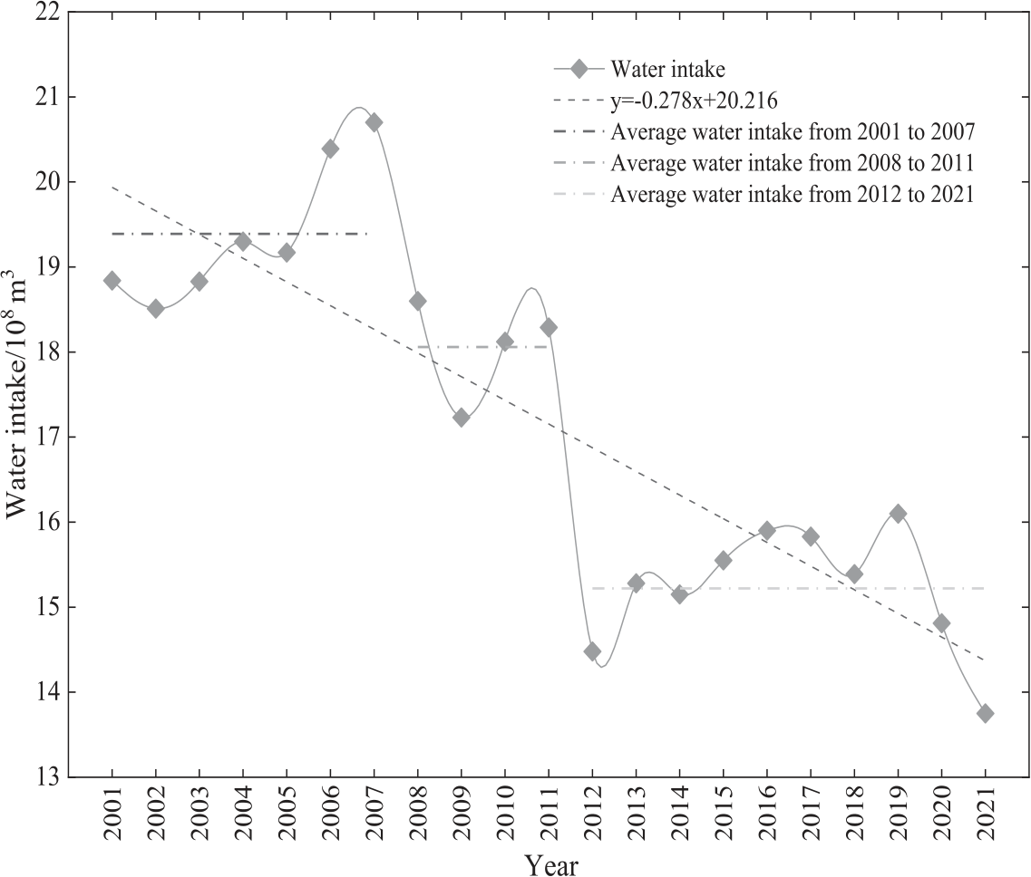
The water supply guarantee rate can reflect whether the water supply can fully meet the water demand to a certain extent. The amount of water in the SRYR has a direct impact on the amount of water resources in QHP. Therefore, according to the data analysis of the water intake of the YR in QHP in the "Yellow River Water Resources Bulletin" from 2001 to 2021 (Fig. 6), in the past 20 years, the water intake of the YR in QHP has decreased at a rate of 0.278 ×10⁸m3/a. It is roughly divided into three stages: a. 2001-2007, the water intake was 19.40×10⁸m3/a, at a high level; b. 2008-2011, compared with the first stage, the amount of water intake declined, basically fluctuating around the level of 18.06×10⁸m3/a, indicating that the "refinement plan for the total control index of the YR water intake permit in QHP" formulated by QHP in 2008 has played a certain legal constraint role in controlling the total water consumption of the YRB in QHP; c. 2012-2021, the water intake of the YR in QHP has shown a "big diving" trend compared with the previous decade. The average annual water intake is 15.22×10⁸ m3/a, and it has been maintained below 15×108 m3/a in the past two years and has a continuous downward trend. In general, the YR can meet the water supply to QHP to meet the regional living production and ecological needs.
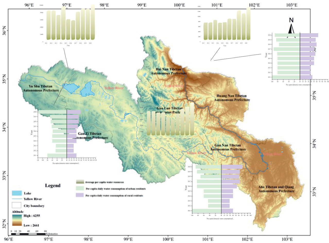
Based on the statistics of water use indicators in Guoluo Prefecture, Yushu Prefecture, and Hainan Prefecture in the "Qinghai Water Resources Bulletin" from 2010 to 2021, the safety status of water use in QHP was further analyzed (Fig. 7). The average annual per capita water resources of the above three states are 76334.8 m3, 74625.8 m3 and 8349.7 m3, respectively, which are much higher than the national per capita water resources level, and the three states show an upward trend at different rates. According to the analysis of the per capita domestic water consumption index, the average daily water consumption per capita of urban residents in Guoluo, Yushu, and Hainan is 71.8 L, 84.5 L, and 66.3 L respectively, and the average daily water consumption per capita of rural residents is 48.8 L, 50.6 L and 41.7 L respectively. According to the relevant standards of "water quota" issued by QHP in 2021, the average daily water consumption of urban residents in Guoluo and Hainan is still lower than the quota standard.
The above data reflect that even though QHP is rich in water resources, the living standards of urban residents still need to be improved, reflecting that there may be a lack of projects in the region, resulting in the inability to replenish domestic water demand in time. Although the average daily water consumption of rural residents can meet the water quota standard, the popularization of rural centralized water supply and tap water still does not reach the level of full coverage. The water supply guarantee rate of the comprehensive reflection area needs to be improved. To this end, QHP has formulated a series of special plans which has refined the development goals and implementation paths to improve the water supply guarantee rate in QHP, especially in agricultural and pastoral areas, by 2025, with the centralized water supply rate and rural tap water penetration rate in rural and pastoral areas of QHP reaching 88% and 85% respectively.
The Water Quality Compliance Rate Needs to be Improved
The water pollution status of the SRYR determines the basis of the water quality situation in the YRB, which is related to the safety of drinking water and industrial and agricultural water security in the provinces along the YR. Because of the small impact of human activities, it is considered that the water quality is not easy to be polluted and in good condition [109]. The "China Ecological Environment Bulletin" and the "Qinghai Ecological Environment Bulletin" in 2021 also show that the water quality of the Yellow River in the source section of the Yellow River is above Class II water.
As of 2020, Yushu Prefecture, Guoluo Prefecture, and Hainan Prefecture have built a centralized drinking water source, and the monitoring results of the water quality of centralized drinking water sources in cities above the prefecture level in QHP in 2022 show that the water quality of centralized drinking water sources in the above three cities is Class III and above standard water. At the same time, the contents of "China Water Tower Ecological Protection Plan" and "Yellow River Qinghai River Basin Ecological Protection and High-quality Development Water Security Guarantee Plan" clearly stipulate that by 2025, the water quality of rivers in QHP will remain in good condition, the people’s livelihood water conservancy infrastructure will be gradually improved, and the water quality compliance rate will be further improved, providing policy support and legal guarantee for regional drinking water safety, and promoting the improvement of water supply guarantee rate, centralized water supply rate, and tap water penetration rate.
In the future, the awareness of water environment protection in the SRYR should be strengthened in the process of water resources development and utilization of the YR, to ensure the stable and sound development of water quality in the source area. At the same time, attention should be paid to the destruction of water quality by unconventional pollutants and new pollutants in life and production, and the level of comprehensive, systematic, and source control of water resources should be gradually improved, to enhance the ability to cope with other ecological risks of different degrees caused by water environment pollution, improve the water quality safety in the source area, and lay a foundation for the water environment quality of "China Water Tower" and the YRB.
Absence of Water Supply Project
Due to the scattered population and weak water supply foundation, there are some problems in the region, such as the imperfect scale of water supply projects, severe engineering water shortage, and unsafe drinking water for farmers and herdsmen. The unsafe types are mainly reflected in poor water convenience, unqualified water quality, insufficient water quantity, and low guarantee rate, among which poor water convenience is the most typical.
To improve the problem of drinking water safety, improve the level of drinking water safety in agriculture and animal husbandry, promote the integration of urban and rural water supply and the standardization of small and decentralized projects, and strengthen the large-scale development of rural water supply projects, QHP has increased the construction of water supply facilities in rural and pastoral areas. If the YR Township of Maduo County, Luozhou, carries out a water supply project construction project, one new water source and one water supply plant are added. At the same time, a water distribution network and related ancillary facilities are built to ensure rural drinking water safety. In the future, while promoting the national large water network, the construction of a regional small water network system should be considered as a whole to ensure urban and rural water supply and improve the ability of water supply security.
Cascade Effects of Water Security Issues
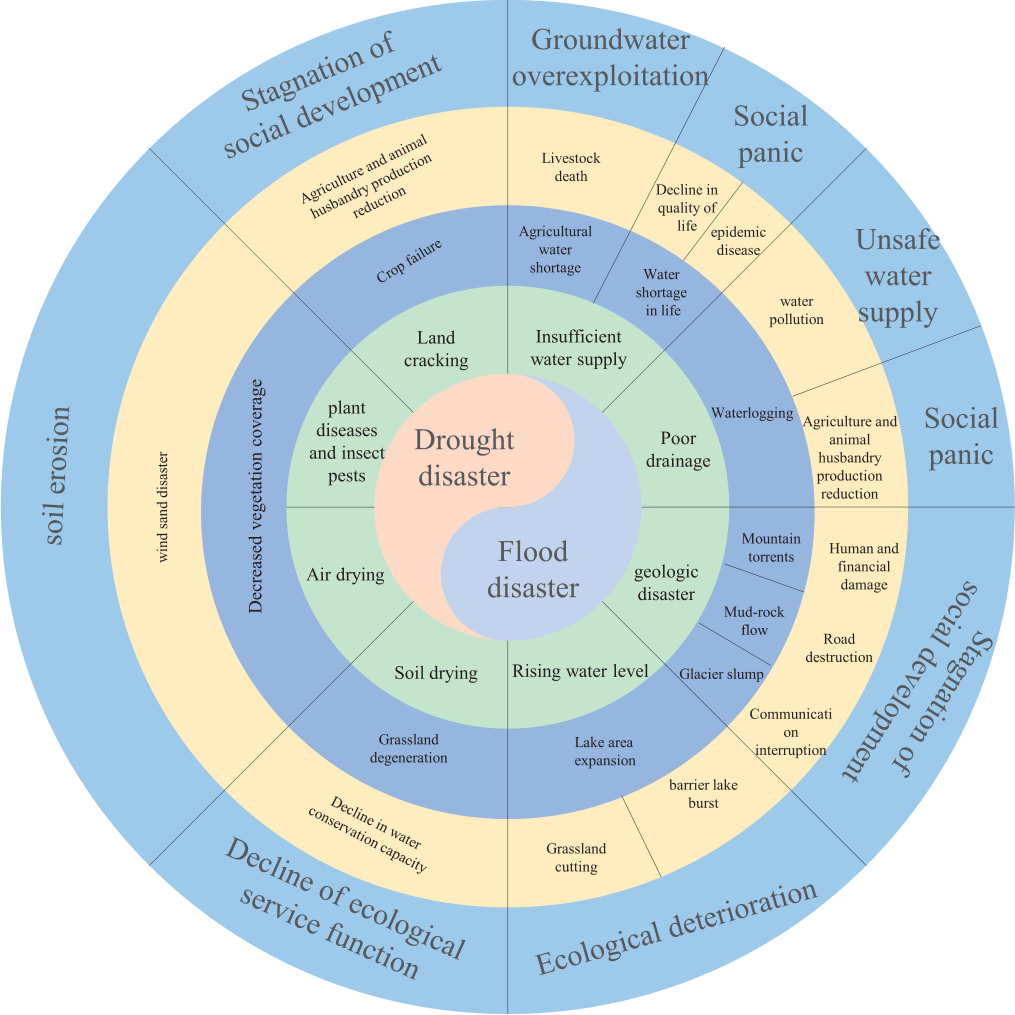
The water security problem is a complex and linked problem system under the coupling response of climate change and human activities. All kinds of water security problems are the embodiment of the cascade effect based on water disasters. Through the combing of the above contents, the following overall cognition of water security problems in the SRYR is formed (Fig. 8).
With climate change, the key climatic and hydrological factors such as precipitation, temperature, and runoff in the SRYR have also undergone great changes. Based on the characteristics of "warming and drying", the climate shows that the temperature rises, the precipitation decreases, and the regional evapotranspiration increases, resulting in frequent drought disasters. Coupled with the interference of human overgrazing, the grassland shows the characteristics of patchy, fragmented, and decentralized degradation, thus reducing the water conservation capacity and ecological service function. At the same time, it changes the balance of surface water and heat, leads to the decrease of groundwater level, and further reduces the runoff yield [110]. It is easy to malignantly act on the grassland in the SRYR, aggravate degradation, deteriorate the ecological environment, and cause a series of secondary disasters such as soil erosion and wind-sand disasters. At the same time, it aggravates the shortage of water resources in the local and middle, and lower reaches, affects the lives of residents, and reduces the harvest of agriculture and animal husbandry, which is not conducive to the stable development of the YRB.
With the increasing trend of climate warming, precipitation showed an increasing trend [106], and the climate characteristics changed to "warm and humid". Warming and precipitation promoted vegetation growth improved the quantity and quality of vegetation, and gradually improved water conservation capacity. At the same time, the process of glacier degradation and snow melting is accelerated, and the water supply of plateau lakes and wetlands is increased, resulting in the occurrence of flood disasters typical of barrier lake outburst floods in the region. It also increases the possibility of secondary disasters such as glacier collapse and debris flow, which will affect road traffic, transportation, and communication. At the same time, the occurrence of flood disasters will damage water supply facilities and sewage discharge conditions to varying degrees, which will easily cause water pollution and threaten the safety of water supply in local and middle, and lower reaches.
Therefore, under the dual factors of climate change and human activities, the state of water security is easy to be first reflected in the situation of flood and drought. Under certain conditions, drought and flood disasters occur and produce chain effects [111]. Different types of disasters induce each other, which ultimately leads to the lag response of disasters and losses in time and space. In terms of time lag, drought leads to grassland degradation and animal husbandry production reduction, which may show the obvious delay in disaster response. The spatial lag is manifested in the fact that drought and flood in the SRYR may affect the water cycle and ecosystem stability in the middle and lower reaches of the river or the QTP. The cascade effect between water security issues will also affect the resilience of the basin. Therefore, in the future, the development and utilization of water resources in the basin must face adaptive regulation of climate change to achieve high-quality development in the YRB.
Conclusion
The SRYR has important strategic significance for ecological protection, high-quality development, and water security guarantee in the YRB, which puts forward higher requirements for diagnosing regional water security problems and clarifying their evolution characteristics. On the premise of clarifying the connotation of water security, this paper diagnoses the following problems of water security in the SRYR by identifying, sorting out, and summarizing relevant research: a. The phenomenon of regional water supply insecurity is typical of engineering vacancy; the total amount of water is sufficient and the water quality is good, but there is still room for improvement in water supply guarantee rate and water quality compliance rate. b. The frequency and intensity of drought events become smaller and weaker, and the trend from drought to flood is significant. The possibility of new flood disasters such as dammed lake outbursts and ice and snow melting is strengthened. c. The regional ecological degradation problem is the most serious and prominent, which is mainly manifested in grassland degradation, serious soil erosion, and low water conservation capacity. However, the ecological degradation problem has been improved and developed in a benign direction. At the same time, it faces a more severe trend of lake area expansion. Attention should be paid to its damage to surrounding engineering facilities and threats to other industries. On the whole, all kinds of water security problems in the SRYR have the characteristics of comprehensive linkage response based on water disasters. In the future, we should think about how to effectively deal with the complex and unstable water security problems in the SRYR and the risks and secondary disasters caused by the two factors of climate conditions and human activities.

