

Introduction
Due to the influence of geology, climate, and human activities [1, 2], the ion composition and distribution of river water could directly reflect the basic characteristics of the basin, even the history of water formation and migration [3]. After different physical and geochemical processes, the content and distribution of different ions not only reflected the different hydrochemical characteristics, but also reflected the relationship between the source, migration, and transformation of solutes and regional natural conditions [4-6]. Generally, the solutes of surface water are mainly derived from rock weathering and the erosion of soils in the drainage basin; these processes are the major components of the exogenic cycle of elements in the continent-river-ocean system [7, 8]. The Ca2+, Mg2+, SO42-, and HCO3- in river water can be attributed mainly to rock weathering. The types and influence degree of rock weathering can be qualitatively analyzed by the Piper plot and Gibbs distribution [9]. Quantitative analysis of rock weathering rates requires the analysis of strontium and its isotopic characteristics [10]. Soil erosion in river basins leads to some metal elements in soil entering water, such as Al, Fe, M, and Mo, which are abundant in the earth’s crust. Some ions still might come from human activities, such as NO3, Pb, and Zn, even though there were relatively few human activities in the area. Sediments are produced by natural erosion and biological processes. Ions that were in river water could enter sediments through physical and chemical actions, including adsorption, sedimentation, and complexation [11]. When the external conditions changed, the ions in the sediment would be released into the water again, which changed the ion concentration and affected the basin characteristics and eco-environment [12-16]. Therefore, it is of great significance to study the river water and sediments together for the evaluation of water environment quality and the protection of the river ecological environment.
The Qinghai-Tibet Plateau is known as the “Asian Water Tower” [17]. It is the birthplace of many major rivers in East Asia, Southeast Asia, and South Asia. Its natural environment and ecosystem hold a special position globally. Due to its unique climate conditions, complex geological structures, and active crustal activity, the region has always been a hot topic of widespread concern and research by scientists. In recent years, with global warming, the accelerated melting of glaciers located on the Qinghai-Tibet Plateau has had an impact on the hydrology and hydrochemistry of the basin [18, 19]. Many studies found that the hydrochemistry of rivers in the Qinghai-Tibet Plateau was mainly controlled by rock weathering [20-22].Global climate change accelerates the weathering and erosion of rocks and influences the ionic content and distribution characteristics in rivers to some extent [23, 24].At the same time, the intensification of human activities has also increased the environmental pressure on plateau rivers. It has become one of the main sources of ions [25].
The source region, located on the Qinghai-Tibet Plateau, is the starting point of the hydrologic cycle in the Lancang River and Yangtze River basins. Its water resource status and changes affect the sustainable utilization of basin water resources [26-28]. The geographical location of the SRYR and the SRLR is relatively close. They are both in the Qinghai-Tibet, and the Dangqu in SRYR and the SRLR both originated from glaciers in the Tanggula Mountains. Therefore, there might be some similarities in the physical and chemical properties and the composition of ions in the river between them. However, most studies about the SRYR or the SRLR were analyzed separately or as a whole, and there were few studies in other fields on comparison between them, except the distribution characteristics of phytoplankton and isotopes [29-36]. Especially, there was little comparative analysis between the ion composition, spatial distribution characteristics, and source of river water and sediment. This study focused on the main ion composition, spatial distribution characteristics, and sources of river water and surface sediments in the SRYR or SRLR, hydrochemical type, and control factors, and comparative analysis was conducted. It can provide basic data and a scientific basis for geochemical processes and the protection of the ecological environment in plateau rivers.
Materials and Methods
Study Area
Located in the central region of the Qinghai-Tibet Plateau [16], the source region of the Lancang River and the Yangtze River are not only important ecological security barriers in China, but also sensitive and fragile areas for climate and ecological environment changes [16, 37, 38]. The Lancang River, also known as the Mekong River, is a famous international river. It originated in the northeast of the Tanggula Mountains in Qinghai Province, China. Its main stream in Qinghai Province is 454 km long, and its catchment area is 3.7×10⁴ km2. The source region of the Lancang River has a dense river network. The first-class tributaries include Zanaqu, Ayong, Budangqu, Shaqu, Banyong, Geruoyong, Ningqu, Ziqu, and Angqu [39]. The Yangtze River is considered to have three sources, namely, Dangqu in the South, Chumaer River in the North, with the Tuotuo River being the main source. The Dangqu originated from the eastern part of Tanggula Mountain in the south of the Qinghai-Tibet Plateau. The Chumaer River originated from Hoh Xil Mountain in the south branch of Kunlun Mountain, which is in the north of the Qinghai-Tibet Plateau. And the Tuotuo River originated from Gladandong Ice Peak, which is the main peak of Tanggula Mountain. The basin area of the source region is about 13.82×10⁴ km2. Its river system is fan-shaped. The main tributaries include the Beilu River, Sewuqu, Moqu, Buqu, Keqiaqu, and Nieqiaqu. There are over 1.1×10⁴ lakes with a total area of approximately 1027 km2 [40].
The source region is located in the transition zone of a cold, semi-arid, and semi-humid climate, with typical climate characteristics of an inland plateau [39]. It is dry and cold, with strong solar radiation and a short frost-free period. Precipitation is concentrated in the summer, accounting for 60% to 70% of the annual precipitation [41]. The source region is high in altitude, low in air pressure, and thin in air. Influenced by the westerly circulation in the upper air, the westerly wind prevails. The water quality of the rivers in the source region is good. Due to the influence of sediment and regional geological conditions, there are certain differences in water quality among different rivers [42, 43]. The river sediment in the source region is controlled by the geological background. Some metallic elements are enriched in river sediments from certain regions, such as Ni, Cd, and Pb. In recent years, with the rapid construction of local road transportation and the development of the social economy, human activities have gradually become one of the most important sources of ions in the Qinghai-Tibet Plateau [44].
Data Collection
According to the actual situation, 17 monitoring sections were selected for research. There were 13 points at the SRYR (JY-01~JY-13), and 4 points at the SRLR (JY-14~JY-17). The location is shown in Figure 1, and the specific information is shown in Table 1. The sampling time was the wet period (July 2022). After the sample collection was completed, it was sealed and packaged before being refrigerated and transported back to the laboratory.
Sample Pretreatment and Detection Method
Surface Water Sample
Surface water samples were collected at a depth of about 10cm and filtered through pre-washed 0.45 μm Millipore nitrocellulose filters. The initial portion of the filtration was discarded to clean the membrane, and the following ones were acidified to pH<2 with ultra-purified 6 M HNO3 and then stored in plastic bottles for trace metal analyses. Cleaning of plastic bottles was carried out by soaking in 20% (v/v) HNO3 for 24 h and then rinsing with milli-Q deionized water (~18 MΩ/cm resistivity; TOC<5 mg/L) from Milli-Q (Millipore, Direct 8).
Field indicators were determined by a Portable Multi-parameter Water Quality Monitoring Analyzer (EXO1, USA). Metallic elements were detected by an Inductively Coupled Plasma Mass Spectrometer (NexION 300X, USA) with a detection limit of 0.06~0.41μg/L and a recovery rate of 86.8~99.8%. Hg was detected by the Atomic Fluorescence Spectrophotometer (AFS-3100, China) with a detection limit of 0.01 μg/L and a recovery rate of 93.0~104.0%. The contents of cations (K+, Na+, Ca2+, and Mg+) were analyzed by a Microwave Plasma Atomic Emission Spectrometer (Agilent 4200, USA) with a detection limit of 1.94~6.61μg/L and a recovery rate of 95.6~108.7%.
The contents of anions (F-, Cl-, SO42-, and NO3-) were analyzed by Ion Chromatography (ICS900, USA) with a detection limit of 0.006~0.018 mg/L and a recovery rate of 99.1~116.3%. The CO32- and HCO3– were analyzed by acid-base titration (methyl orange as an indicator and diluted hydrochloric acid titration) with an error of less than 5%.
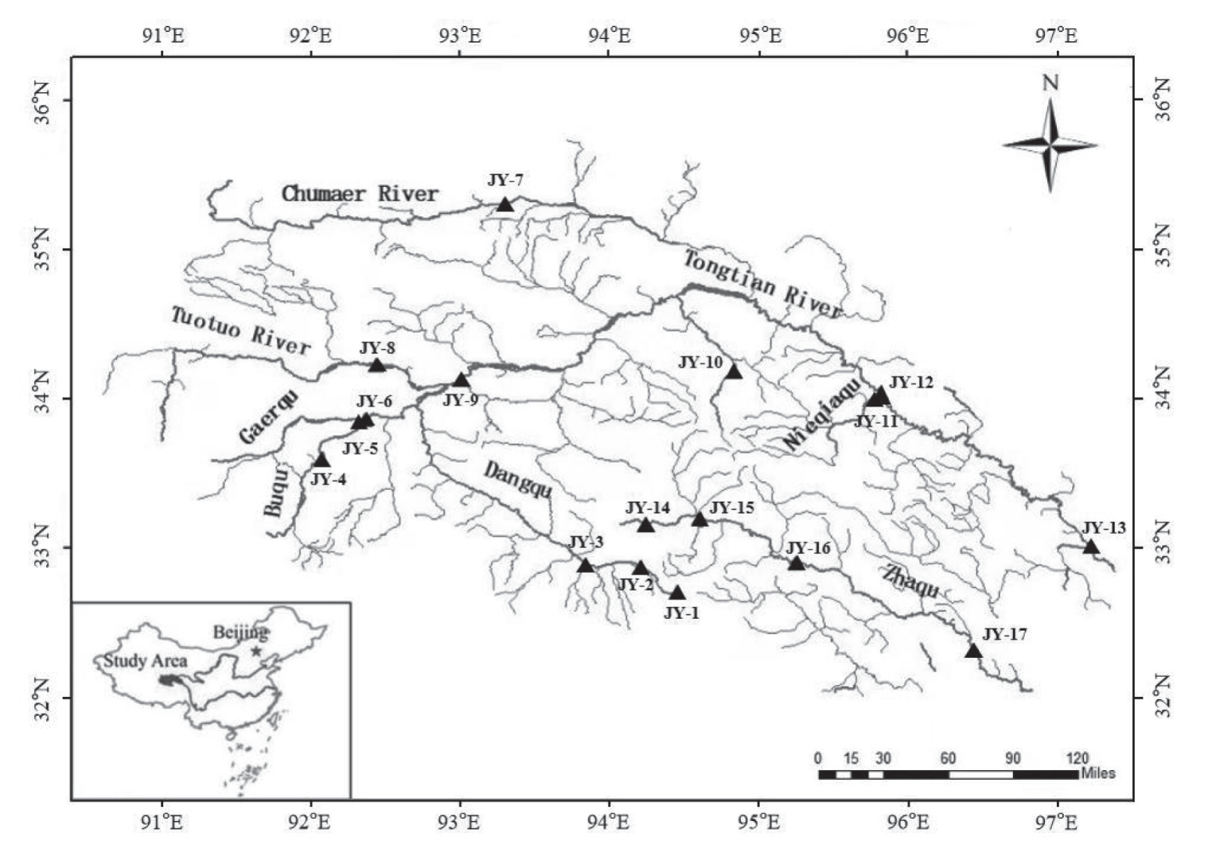
Table 1.
Basic information table of sampling points
Sediment Sample
After being naturally dried, sand and gravel were removed from the sediment. It was ground before passing through a mesh sieve with a pore size of 0.075 mm. According to the literature method [45-47], sediment samples were digested by a Microwave Digestion Instrument (MARS6, USA). Metallic elements in the sediment were detected by an Inductively Coupled Plasma Mass Spectrometer with a detection limit of 0.04~2.0 mg/kg and a recovery rate of 75~120%. Hg in the sediment was detected by an Atomic Fluorescence Spectrophotometer with a detection limit of 0.002 mg/kg and a recovery rate of 80%.
Analytical Method
The hydrochemical characteristics, distribution characteristics, and source of the main ions were analyzed by the Piper plot, Gibbs diagram, and Ion ratio. The possible sources of metallic elements in sediment were analyzed by combining correlation analysis with principal component analysis. The analysis software was SPSS 26. The mapping software was Origin 2021.
Results and Discussion
Distribution Characteristics and Source of Ions in Water
Physical and Chemical Properties Analysis
According to the study results (Table 2), the main rivers in the SRYR were alkalescence, and the temperature difference was large. The pH range was 8.2~8.8. The water temperature range was 7.5~18.6℃. The dissolved oxygen (DO) range was 7.0~9.3 mg/L. The redox potential (ORP) range was 16.0~109 mV. The conductivity range was 333~5326 μS/cm. The total dissolved solids (TDS) range was 145~2875 mg/L.
Similar to the SRYR, the main rivers in the SRLR were alkalescence, and the temperature difference was large. The pH range was between 8.3 and 8.6. The water temperature range was 9.7~17.3℃. The DO range was 7.6~8.8 mg/L. The ORP range was 22.3~56.9 mV. The conductivity range was 709~2160 μS/cm. The TDS range was 423~1281 mg/L.
The average value of TDS in the source region was 647.3 mg/L and 702.2 mg/L, both of which were much larger than the world average of 150 mg/L [48]. It might be caused by geotectonic movement [34]. The uplift of the Qinghai-Tibet Plateau is the result of tectonic movement, which caused landform ups and downs, and led to the exposure of fresh rocks to accelerate the weathering process [49, 50]. It had caused an increase in the content of ions, such as K+, Na+, Ca2+, and Mg2+, entering the river basin through weathering, and TDS was closely related to these ions. Therefore, the tectonic movement had affected the TDS content, making it higher than the world average. The total hardness (TH) range in the SRYR was 279~693 mg/L, and the average value was 647.3 mg/L. The TH range in the SRLR was 338~812 mg/L, and the average value was 620.2 mg/L. It was much larger than the average value of the Yangtze River and the Lancang River basins (291.6 mg/L and 164.4 mg/L), which indicated that the water hardness in the source area was relatively high [51-53].
Most of the river water in the source region was fresh water, with medium or high hardness, and only a small fraction was brackish water with high hardness (Figure 2). This might be caused by complex topography and a changeable local climate [54]. It was reported that the Qinghai Provincial Government implemented an emergency drainage project in 2019. The high salinity lake water located in the upper reaches was guided into the Chumaer River, which led to an increase in salinity in the Chumaer River [55, 56].
Table 2.
Physical and chemical properties in river water
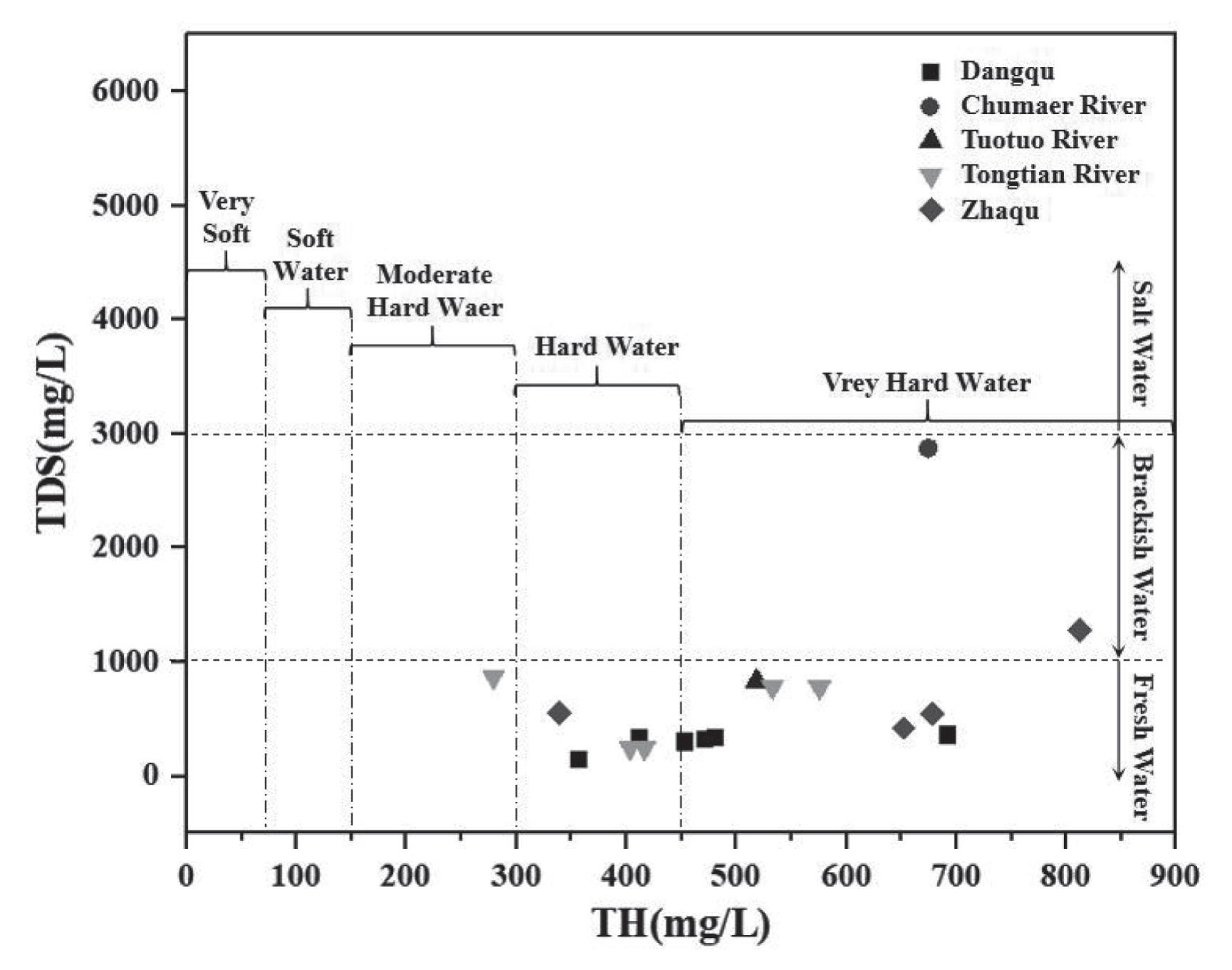
Table 3.
Anions and cations content of the river water in source region (unit: mg/L)
Characteristics of Ionic Content and Spatial Distribution in Water
(1) Content and Distribution Characteristics of Main Ions
K+, Na+, Ca2+, Mg2+, Cl-, SO42-, CO32-, and HCO3- were the main anions and cations in the river water of the source region (Table 3). The ionic content varied among different regions. The average content of the main cations in the river water of the source region was the same, which was Ca2+>Na+>Mg2+>K+. However, the average content of anions was different. The SRYR was Cl->SO42- >HCO3->CO32-, and that of the Lancang River was SO42- >Cl->HCO3->CO32-.
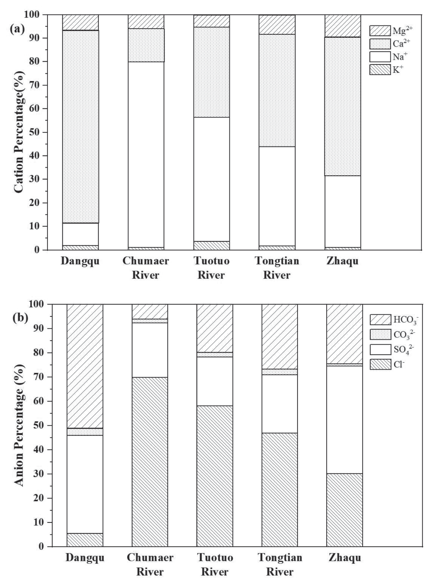
The content difference and spatial distribution characteristics were clarified by calculating the proportion of ions (Figure 3). In the source region, the main cations in river water were Ca2+ and Na+, with a combined proportion of over 89%. The main anions were Cl-, SO42-, and HCO3-, with a combined proportion of over 97%.
In the SRYR, the main ions in Dangqu were Ca2+ (81.9%), SO42- (40.5%), and HCO3- (51.3%). In the Chumaer River, they were Na+ (78.9%) and Cl- (69.9%). In the Tuotuo River, they were Ca2+ (38.3%), Na+ (52.8%), and Cl- (58.1%). In the Tongtian River, they were Na+ (42.2%), Ca2+ (47.7%), and Cl- (47.7%). The main ions, which were in the river water of the SRLR, were similar to those of the Tongtian River, but the proportions of Ca2+ (58.9%) and SO42- (44.3%) were higher. It might be due to the different sources of ions leading to differences in ion content, especially the processes of rock weathering and evaporation-crystallization, which had a great influence on the content of anion and cation in water [3, 57].
(2) Content and Distribution Characteristics of Metallic Elements
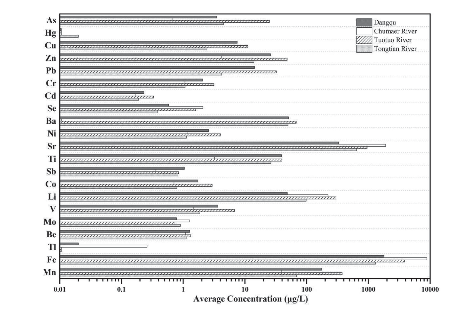
From Figure 4, it was found that in the SRYR, the order of the average contents of metallic elements in river water was Sr > Ba > Ti > Zn > Pb > As > Cu > Cr > Ni > Se > Sb > Cd, and in the SRLR, it was Sr > Ba > Zn > As > Cu > Se > Ni > Cr > Sb > Ti > Pb > Cd. Combined with the average contents of Sr, Ba, and Zn in the source region of the Yellow River, it was found that the average contents of these three metallic elements, which were in the Sanjiangyuan Region, were obviously higher than in other regions. This was due to the Sanjiangyuan Region being located in the Qinghai-Tibet Plateau and influenced by glacial meltwater, rock weathering, and the geological background of the Qinghai-Tibet Plateau [58-60].
In the SRYR, the average content of Zn, Se, Ba, Sr, or Sb in river water was flat with the SRLR, while As, Cu, Pb, Cr, Cd, Ni, or Ti were higher (Figure 4). In particular, the average contents of As, Cu, Pb, Cr, and Ti are several times or even dozens of times higher. This might be due to the fact that there were three sources in the SRYR, but only Dangqu originated from glaciers in the Tanggula Mountain, the same as the SRLR [30]. The Tuotuo River and Chumaer River were different from the SRLR in origins and geographical locations [61, 62], resulting in the average contents of these metallic elements in the SRYR being different from those in the SRLR. According to Figure 5, it could be found that the ratio of average contents of As, Cu, Pb, Cr, and Ti in the Tuotuo River and Chumaer River were relatively high in the SRYR, which was the reason why these metallic elements in the SRYR were higher than those in the SRLR.
Compared with the source region of the Yellow River [63, 64], the average contents of Cd, Se, Ni, or Sr in the SRYR were flat, while those of As, Zn, Ba, or Sb were lower and Cu, Pb, Cr, or Ti were higher. The average contents of Cu, Cr, Cd, Se, Ba, or Sr in the SRLR were flat with those in the source region of the Yellow River, while As, Zn, Pb, Ni, Ti, or Sb were lower. Except for Sb, the average contents of other metallic elements in river water of the SRYR were higher than the average values of the Yangtze River basin and the World Rivers [48, 65].
From Table 4. [66, 67], it was found that the historical background values of elements in the source region, such as Ni, Cd, Cr, Pb, Zn, Cu, and As, were higher than those in the Yangtze River basin and the World Rivers, which showed that the content difference of these elements was influenced by the background value. The source region was rich in mineral resources. Copper mine reserves account for about 40% of the total reserves in China, and lead ore and zinc ore reserves account for about 30% [68]. Under the natural effects of rainfall, leaching, and rock weathering, these metal elements entered the river, which made the contents in the source region higher than those in other areas. In addition, human activities such as railway and road construction, tourism development, and the increase of animal husbandry in the source region also lead to an increase in Pb, Ti, and Se contents. To sum up, the different background values of rivers, as well as the influence of natural factors and human activities, might lead to the differential distribution of metallic elements in the source region [69-71].
There were differences in the spatial distribution of metallic elements in different rivers in the SRYR. The average contents of Hg, Cr, Cd, Se, Ni, Sb, Co, V, Mo, or Be in different rivers were flat, while the average contents of other ions varied. The average contents of Cu, Zn, Pb, Ba, Ti, or Mn in the Dangqu River were higher than those in the Tuotuo River, Chumaer River, or Tongtian River. The Sr, Li, Tl, or Fe in the Chumaer River were higher than those in other rivers. Except for Se, Sr, Sb, Mo, Tl, and Fe, the average contents of other metallic elements in the Tuotuo River were higher than those in other rivers. In the Tongtian River, only Hg was higher than that in other rivers.
Analysis of Hydrochemical Characteristics and Main Control Factors
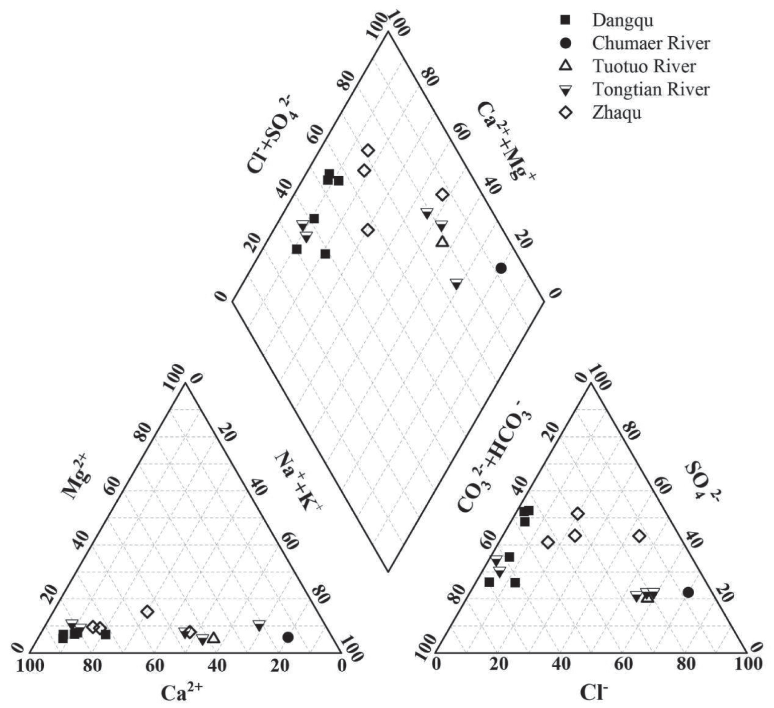
The Piper plot (Figure 6) provides a way to visualize the compositions and water types of rivers and therefore, can show the relative importance of different weathering regimes [29]. On the cation diagram, samples from Zhaqu and Dangqu lie in the lower-left corner, where the Ca values are high (more than 50%), revealing that the dominant cation in these samples is calcium. On the contrary, samples from the Chumaer River and Tuotuo River fall on the lower-right corner, where the dominant ion is sodium, showing the characteristics of evaporites. The values of samples from the Tongtian River are relatively scattered, but still show that the dominant ions are Ca and Na. On the anion diagram, the samples from Dangqu and a part of the Tongtian River fall on the left, showing carbonate rock weathering features. However, samples from the Chumaer River, the Tuotuo River, and a part of the Tongtian River fall on the lower-right corner, revealing chloride-dominated features. The values of samples from Zhaqu are relatively scattered. According to the Piper plot (Figure 6), the main hydrochemical types in the source region are Na-Cl and Ca-SO4•HCO3, but they are diverse in different rivers in the SRYR. The hydrochemical type of the river water in Dangqu is Ca-SO4•HCO3, which indicates that it may be affected by the evaporites, carbonate, and silicate rocks [72]. That of river water in the Tuotuo River and Chumaer River is Na-Cl, affected by evaporite dissolution [34, 73, 74]. In the Tongtian River, the hydrochemical types are Na-Cl and Ca-HCO3. That of the trunk stream is Na-Cl, which has the same hydrochemical type as the Chumaer River and Tuotuo River, indicating that their ion has a great impact on that of the Tongtian River.
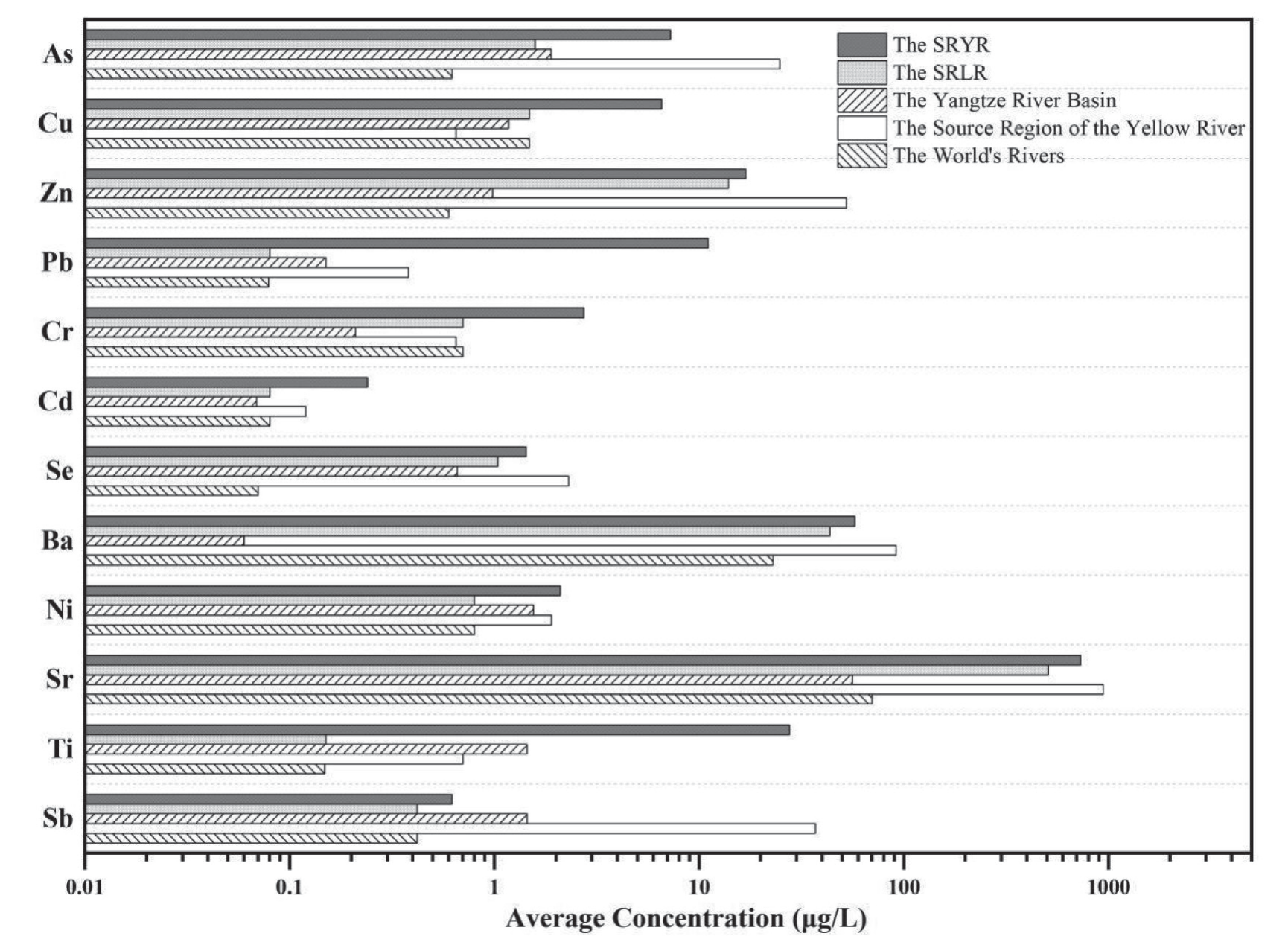
Table 4.
The background value of metallic elements in the river (unit: μg/L)
| Rivers | As | Cu | Zn | Pb | Cr | Cd | Ni |
|---|---|---|---|---|---|---|---|
| The SRYR | 2~38 | 0.73~23.1 | 0.99~66.4 | 1.12~57.1 | 0.26~48.8 | 0.04~0.5 | 0.33~6.1 |
| The Yangtze River Basin | 1.89 | 1.17 | 0.98 | 0.15 | 0.21 | 0.07 | 1.55 |
| The World Rivers | 0.6~13 | 1~6 | 4~10 | 0.2~6 | 0.08~2.1 | 0.01~0.2 | / |
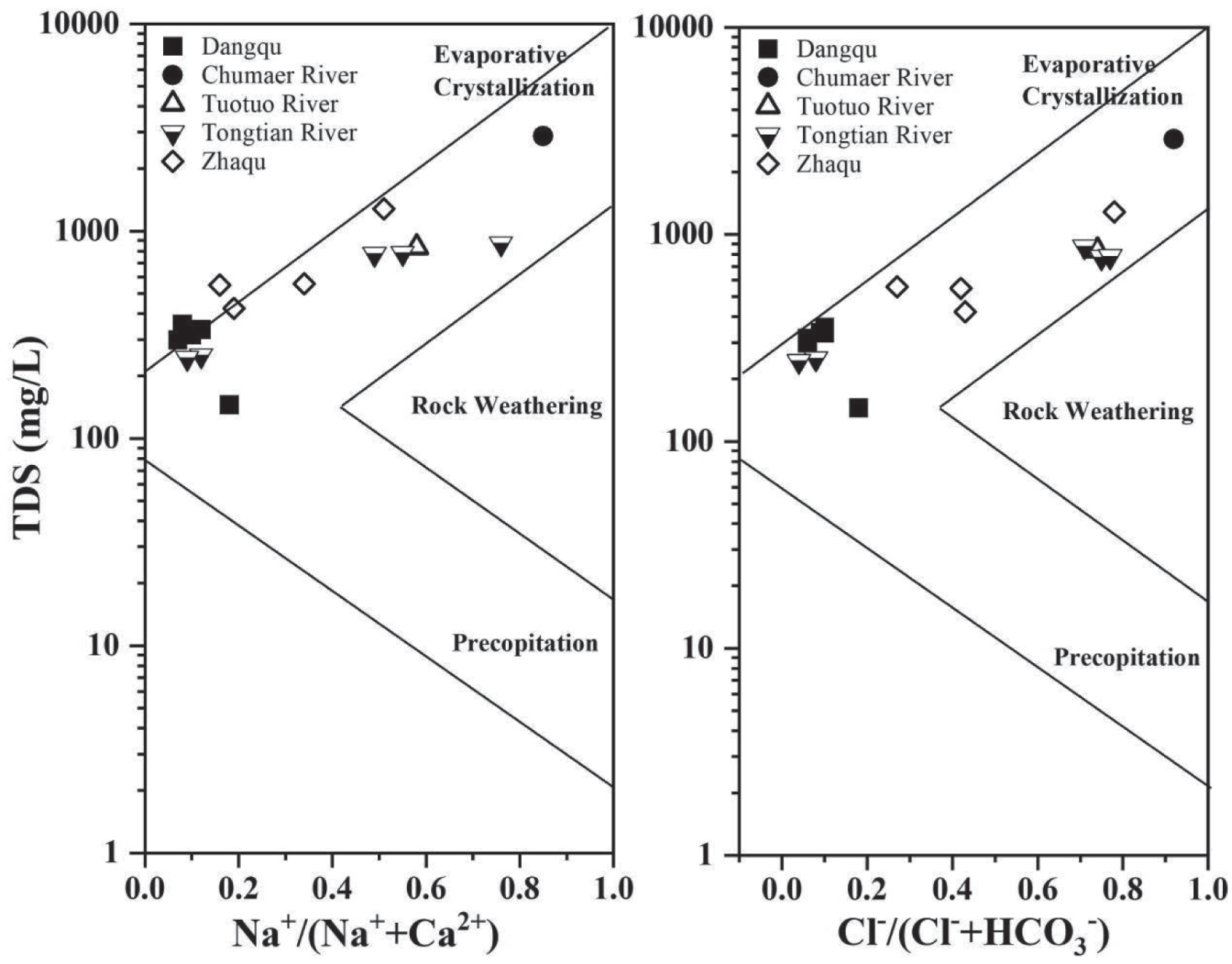
Gibbs defined the mechanisms controlling world surface water chemistry as three end-members: atmospheric precipitation, rock dominance, and the evaporation-crystallization process. To distinguish the contribution of the three end-members, TDS versus Na+/(Na++Ca2+) or Cl-/(Cl-+HCO3-) are used [75]. The Gibbs schematic diagram is shown in Figure 7. The river water of the source region is characterized by moderate or high concentrations of TDS, indicating that the dominant factor is rock weathering and evaporation-crystallization processes, and none of the rivers are affected by precipitation [76]. The diagram reveals that the river waters of Dangqu are characterized by low ratios of Na+/(Na++Ca2+) and Cl-/(Cl-+HCO3-) (less than 0.5) and moderate concentrations of TDS (about 100 to 400 mg/L), typical of rock-dominant rivers. Chumaer River is characterized by high ratios of Na+/(Na++Ca2+) and Cl-/(Cl-+HCO3-) (approaching 1) and high concentrations of TDS, showing that the controlling factor is evaporation-crystallization processes. However, Tuotuo River and Tongtian River are in an intermediate state, having moderate values of TDS and ratios of Na+/(Na++Ca2+) and Cl-/(Cl-+HCO3-), as is the river in the SRLR. They are controlled by rock weathering and evaporation-crystallization processes [32]. These results and conclusions are consistent with the Piper plot (Figure 6).
Analysis of Ion Sources in Water
The way of ions’ sources in river water can be divided into natural or anthropogenic. Natural sources are atmospheric transmission and rock weathering. Anthropogenic sources are influenced by human activities such as mineral development, agriculture, and animal husbandry, and so on [70, 77, 78]. The source of river ions can be determined by calculating the ratio of different ions.
(1) Atmospheric Transmission
In the process of atmospheric transport, a large amount of water vapor with many ions comes from the evaporation of seawater. By comparing the values of Na+/Cl− and K+/Cl− in the source region with the average value of seawater in the world, the contribution of atmospheric transport to the ions in the source region could be judged [79].The average values of Na+/Cl− (1.46) and K+/Cl− (0.20) in the river water of the SRYR were much larger than the World Seawater Average (Na+/Cl−=0.86, K+/Cl−=0.02). It shows that the Cl- was less affected by seawater. Because the SRYR was far away from the ocean and controlled by westerly circulation and monsoon circulation, the contribution and influence of ocean sources to the Cl- were both less, and it had no obvious contribution to other ions [80, 81]. Therefore, it was considered that atmospheric transport was not the main way of ions’ source in the SRYR.
In the source region of Lancang River, the average value of Na+/Cl−(0.74) in river water was slightly less than the World Seawater Average, while K+/Cl− (0.04) was slightly larger, which indicated that the natural source route of ions was influenced by other factors besides atmospheric transport [31, 82].
(2) Rock Weathering
Rock weathering with different lithologies can produce different ions, which can reflect how that affects ions [83]. Na+ and K+ in natural water mainly come from evaporites or silicate rock weathering. Ca2+ and Mg2+ may come from evaporites, carbonate, or silicate rock weathering. Cl- and SO42- mainly come from evaporite weathering. And HCO3- mainly comes from carbonate rock weathering [84, 85].
In the SRYR, the molar equivalent ratios of Cl-/Na+ in the river water were less than or equal to one (Figure 8), which indicated that Na+ and Cl- were greatly influenced by the evaporites. It should be paid special attention to that the Cl-/Na+ ratio of Dangqu and some areas of the Tongtian River was located at the lower right side of the isogram, which indicated that those areas might be affected not only by evaporites, but also by silicate rock weathering. The ratio of all samples was located above the (Ca2++Mg2+)/ HCO3- and (Ca2++Mg2+)/(SO42-+HCO3-) isograms, and closer to the (Ca2++Mg2+)/(SO42-+HCO3-) isograms, indicating that Ca2+ and Mg2+ were affected not only by carbonate rock weathering, but also by evaporites [86]. The ratios of the Dangqu and part of the Tongtian River were located around the HCO3-/(Cl-+SO42-) isogram, which indicated that those areas were affected by carbonate rocks and evaporites [87]. While the ratios of Chumaer River, the Tuotuo River, and part of the Tongtian River were located at the lower right side of the HCO3-/(Cl-+SO42-) isogram, showing that those areas were effected by evaporites more than carbonate rocks.
Fig. 8.
The molar equivalent ratios of different ions (a. Cl-/Na+; b. (Ca2++Mg2+)/HCO3 -; c. (Ca2++Mg2+)/(SO4 2-+HCO3 -); d. HCO3 -/(Cl-+SO4 2-))
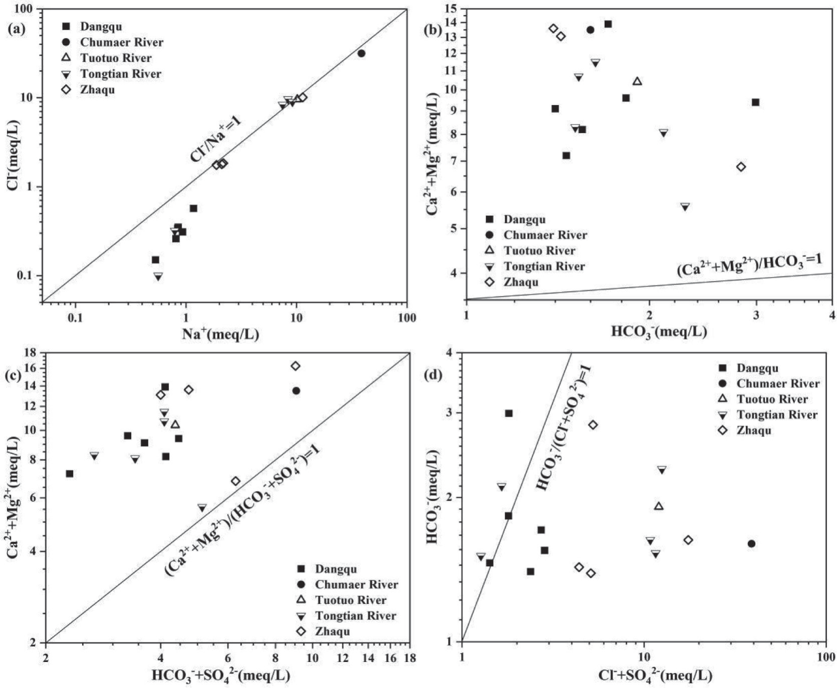
In the SRLR, the molar equivalent ratio of Cl-/Na+ was about 1 and the ratios of (Ca2++Mg2+)/HCO3- and (Ca2++Mg2+)/(SO42-+HCO3-) were located at the upper left of the isogram, which indicated that Na+ and Cl- were effected by evaporites and Ca2+ and Mg2+ were influenced by carbonate rocks and evaporites. In addition, according to the ratios of HCO3-/(Cl-+SO42-), the main ions were more affected by the evaporites than carbonate rocks.
(3) Human Activities Affect
In recent years, with the development of tourism and the increase of grazing activities in Tibetan areas, the hydrochemical characteristics in the source region may change accordingly [88]. The NO3- can serve as an indicator of the degree of impact of human activities on the water environment [48, 89]. The NO3- content in the river water of the source region was low as a whole. In the SRLR, the NO3- content ranged from 1.77 to 2.88 mg/L, with an average of 2.19 mg/L. In the SRYR, that was 0.40~2.71 mg/L, with an average of 1.46 mg/L. The NO3- concentration in the natural background value is generally 0.08~0.16 mg/L [90]. In the SRLR and the SRYR, the NO3- concentration is higher than the natural background value. Therefore, it may be affected by human input.
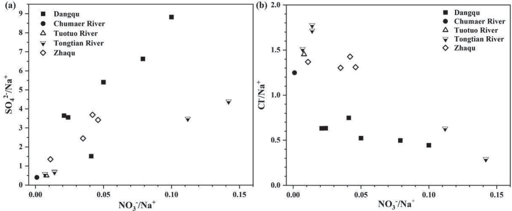
To further investigate the impact of human activities on the river water in the source region, the ratios of NO3-, SO42-, and Cl- normalized by Na+ were used to distinguish between human sources and nature sources. However, there was no obvious correlation between NO3-/Na+, SO42-/Na+, and Cl-/Na+ in river water (Figure 9), which showed that the sources of NO3- were different from SO42- and Cl-. The Cl- and SO42- mainly come from evaporite weathering, which belongs to a kind of natural source. Therefore, the NO3- may come from human inputs. Anthropogenic sources are usually divided into industrial sources and agricultural sources. Generally, industrial sources are associated with higher NO3-/Cl- and SO42-/ Ca2+, while agricultural sources are characterized by low NO3- and high Cl-. However, the geographical location of the study area is special, with an average elevation of more than 4000 m, and no industrial sources were found in the study area during the field investigation, so the input of agricultural sources was considered. In Figure 9, the NO3-/Na+ was obviously much lower than the Cl-/ Na+ which meant high Cl-/NO3-. In other words, it meant low NO3- and high Cl-. Therefore, the river water of the source region was affected by agricultural sources to a certain extent [54]. Due to the low content of NO3-, it was speculated that human activities had a relatively small impact on the ions.
Distribution Characteristics and Source of Metallic Elements in Sediments
Content and Distribution Characteristics of Metallic Elements in Sediments
Metallic elements are a special group of ions because heavy metals have persistence and potential toxicity to the environment, which can change the activity processes of microorganisms and can be accumulated through sediments and aquatic food chains [91]. The content of metals in sediments is an important factor affecting river water, because metals can be transformed into each other in sediment water. Analyzing the content, species, and distribution characteristics of metal elements in sediments is helpful to determine the pollution degree of metals in rivers and their potential pollution risks. Therefore, the analysis of metallic elements in sediment is very important for assessing the state of the river.
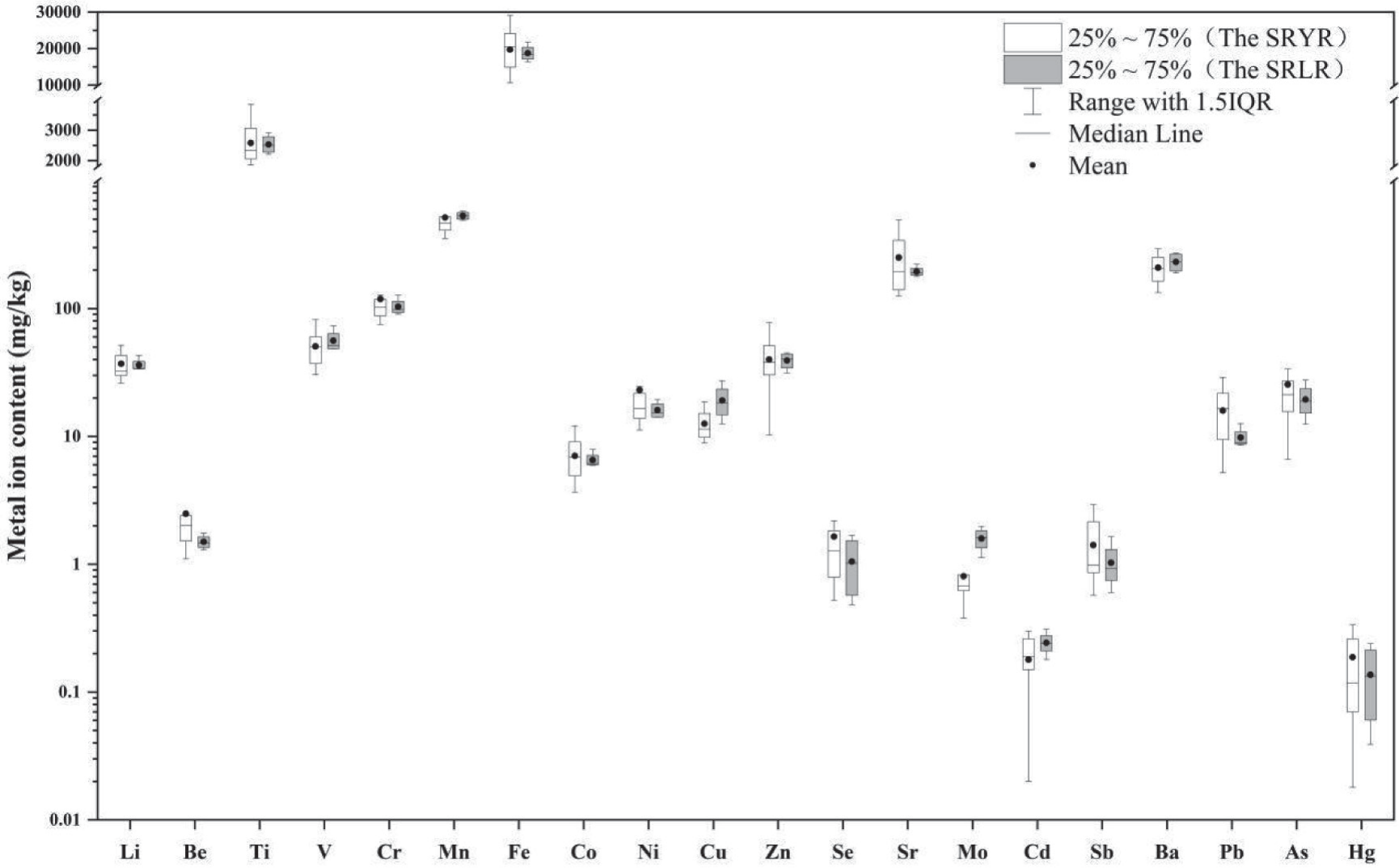
Compared with other metallic elements, the average contents of Ti, Mn, Fe, Sr, and Ba in the sediment of the source region were relatively higher (Figure 10). In the SRYR, the average content of Fe in the sediment was 19758 mg/kg and Ti was 2581 mg/kg. In the SRLR, that of Fe was 18736 mg/kg and Ti was 2533mg/kg. It was mainly due to the high background value of some metallic elements in river sediments in the source region [46, 92].
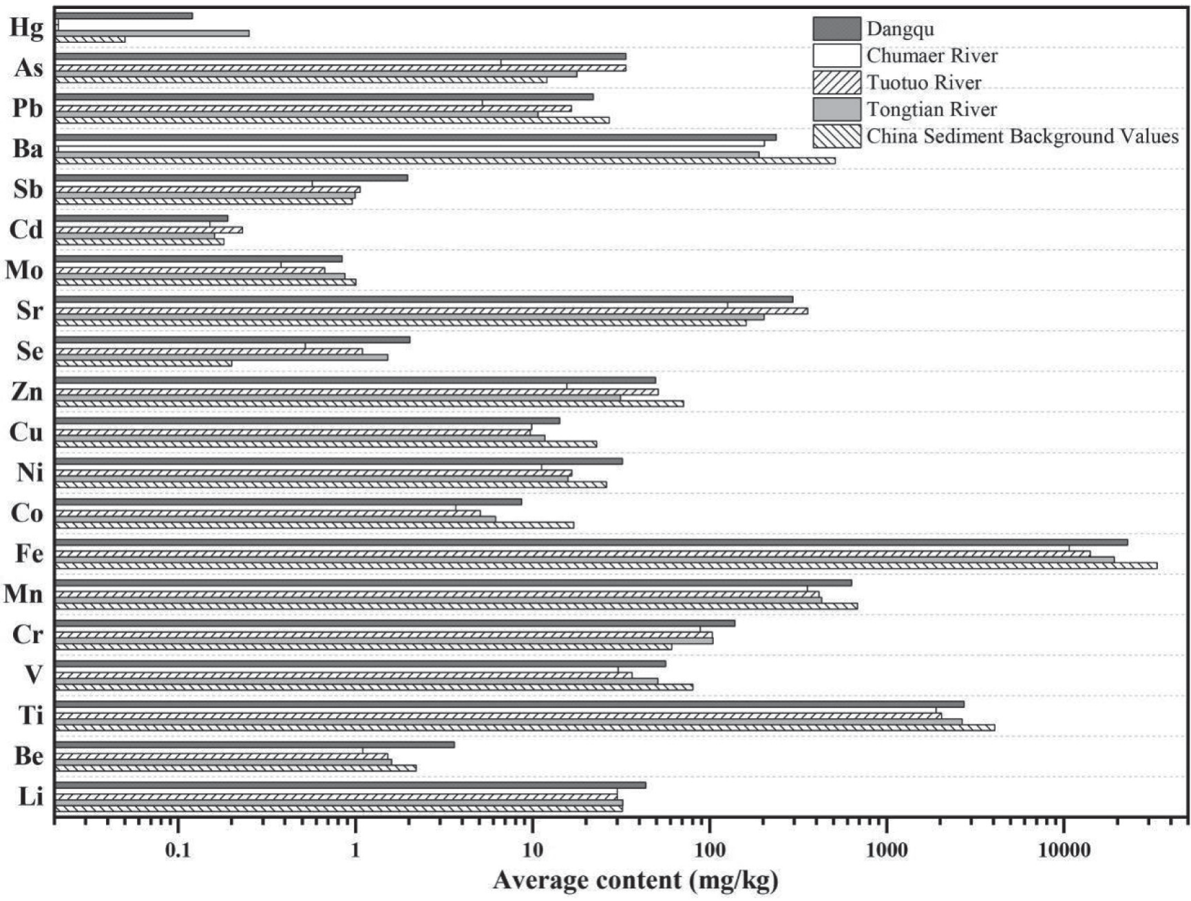
In the SRYR, the average contents of Cd, Mo, Sr, Se, Cu, Co, Fe, Mn, Cr, V, Ti, and Li in the sediments of different rivers were basically flat, while those of the others were different in spatial distribution (Figure 11). In the sediments of the Dangqu River, the average contents of Hg, As, Ba, Sb, Ni, and Be were higher than those in the Tuotuo River, Chumaer River, and Tongtian River. In the sediments of the Chumaer River, the average contents of Hg (below the detection limit), As, Pb, Sb, Zn, Ni, and Be were lower than those in other rivers. In the sediments of the Tuotuo River, Hg, and Ba were below the detection limit, and the average contents of other metallic elements were flat with those of other rivers. In the sediments of the Tongtian River, only the average content of Hg was obviously higher than that of other rivers, and others were flat or lower.
Compared with the average background value of Chinese river sediment [93, 94], in the sediments of the Dangqu River, the average contents of Pb, Ba, Zn, Cu, Co, Fe, Mn, V, and Ti were obviously lower, Cd, Mo, and Ni were basically flat, and Hg, As, Sb, Sr, Se, Cr, Be, and Li were higher. Except for Se and Cr, the average contents of other metallic elements in the Chumaer River were lower than the average background value of Chinese river sediment. In the Tuotuo River, the average contents of As, Sr, Se, and Cr in sediments were obviously higher, while Sb, Cd, Mo, and Cr were flat and other metallic elements were lower. In the Tongtian River, the average contents of Hg, As, Sr, Se, and Cr in sediments were relatively higher, while Sb, Cd, Mo, and Li were flat. The other metallic elements were lower than the average background value of Chinese river sediment.
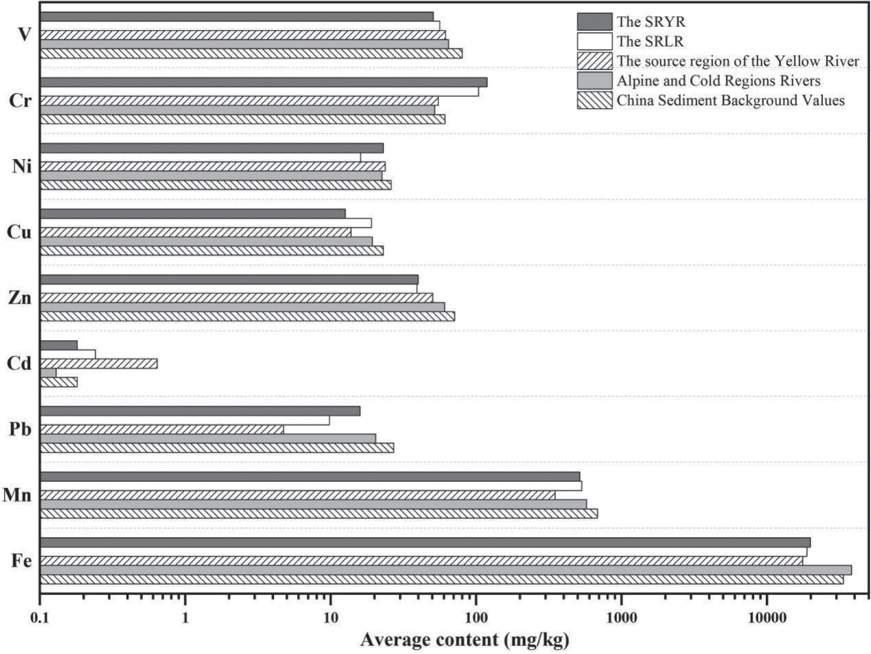
In the SRLR, the average contents of Cr and Cd in sediments were slightly higher than the background values of sediments in the China River system (Figure 12), while V, Ni, Cu, Zn, Pb, Mn, and Fe were lower. Some studies indicate that it was the rocks containing Cd and Cr that affected the content of metallic elements in sediments [95, 96].
As shown in Figure 12, the average contents of metallic elements in the sediments in the SRYR were basically flat compared to those in the SRLR. Compared with the source regions of the Yellow River and other rivers in alpine and cold regions, the average contents of V, Ni, and Zn in the sediments of the source regions were slightly lower, while Cr was slightly higher. Cd was lower than that in the source region of the Yellow River, but higher than that in rivers in alpine and cold regions. Pb, Mn, and Fe were higher than those in the source region of the Yellow River, but lower than those in rivers in alpine and cold regions.
Analysis of the Source of Metallic Elements in Sediments
Correlation analysis can be used to infer the homology between various metallic elements and reveal the source relationship of ions based on the significant level of correlation [60, 92]. Considering that the amount of samples affects the analysis accuracy, the metallic elements in the sediments of rivers in the source region measured by our study team in the past five years (2019~2022) were selected to complete the relevant analysis.
The Pearson Correlation Coefficient is shown in Table 5. In the SRLR, the results show that there was a significant positive correlation (p<0.05) between Fe and Ti, V; Pb, V, Co, Sr, Sb, Co, Cr, and Ni were pairwise correlated; Cu, Sr, Cb, and Sb were pairwise correlated; Be, Mn, and Ni were pairwise correlated. It indicated that these metallic elements had a certain degree of correlation with each other, and their sources might have similarities and homology. In the SRYR, Li and Be were significantly positively correlated with most ions; T, V, Mn, Fe, Co, and Cu were pairwise correlated; Mn and Co were significantly positively correlated with Ni, Se, and Pb; there was a significant positive correlation in Se-Sr and Sr-Cd-Pb. It indicated that these metallic elements were highly correlated (p<0.01) and might have similar sources. However, not all metallic elements had a significant correlation, which indicated that their sources were not completely consistent.
In order to further analyze the main sources of metallic elements, the principal component analysis method was used to analyze the sediments in the source region. Under the premise of a 95% confidence level, three principal components (eigenvalues>1) of sediments were extracted, respectively. In the source region of the Lancang River, the contribution rates of the first and second principal components were 67.15% and 20.65%, and the cumulative contribution rate was 87.8%. In the SRYR, the contribution rates of the first and second principal components of sediments were 45.97% and 35.05%, and the cumulative contribution rate was 81.02%.
The results of the principal component analysis are shown in Table 6. In the SRLR, the first principal component contribution rate of the metallic elements in river sediments (67.15%) was much higher than that of other principal components. The metallic elements with a higher load were Be, Ti, V, Cr, Fe, Co, Ni, Cu, Zn, Sr, Cd, Sb, and Pb, and the metallic elements of the second principal component were Li and Mn. In the SRYR, the first principal components of metallic elements with a higher load in river sediments were Li, Be, V, Mn, Fe, Co, and Ni, and the metallic elements of the second principal component were Zn, Sr, Cd, Sb, and Pb. According to the correlation analysis, these metallic elements had a significant correlation, which indicated that their sources were similar or the same. According to the literature research, Fe and Mn were abundant macro-elements in the crust [97, 98]; Ni and Co were controlled by the geological background of the Qinghai-Tibet Plateau [99]; Pb, Zn, and Ba were often used as identification elements of traffic pollution sources [100, 101]. Although the values of Pb, Zn, and Ba in the study area were lower than the background values of sediments in China, there was a significant correlation between Sr and Sb with Pb and Zn, while the values of Sr and Sb were higher than the background values of sediments in China. Therefore, Sr and Sb might be affected by traffic pollution sources. In conclusion, it was considered that the metallic elements in the sediments of the source region were controlled by both natural and traffic pollution.
Table 5.
Pearson correlation coefficient of metallic elements in sediments
Table 6.
Principal component analysis of metallic elements in sediments
Conclusion
In general, the river water in the source region was medium or high-hardness fresh water. The water of the Chumaer River was high-hardness brackish water due to geological conditions and engineering impacts. The main cations in the water of the source region were Ca2+ and Na+; and the main anions were Cl-, SO42- and HCO3-. There were some differences in the content of metallic elements in the water. The average contents of As, Cu, Pb, Cr, Cd, Ni, and Ti in the river water of the SRYR were higher than those in the SRLR.
The main hydrochemical types in the source region are Na-Cl and Ca-SO4•HCO3, which are mainly controlled by rock weathering and evaporating crystallization. However, it was diverse in different regions. The hydrochemical type of the river water in Dangqu was Ca-SO4•HCO3, controlled by rock weathering; in the Tuotuo River and the Chumaer River, this was Na-Cl, controlled by evaporating crystallization; and in Tongtian River, this was Na-Cl and Ca-HCO3, controlled by rock weathering and evaporating crystallization. The ions in the river water of the source region were less affected by atmospheric transport and human activities, but more affected by rock weathering. In the SRLR, the water ions were mainly affected by evaporites and carbonate rocks. And in the SRYR, those were mainly affected by evaporites, silicates, and carbonate rocks.
In the source region, the average contents of Ti, Mn, Fe, Sr, and Ba in the surface sediments of rivers were higher than those of other metallic elements. Compared with the background value of sediments in China, the average contents of Cr and Cd in the source area were higher. Compared with the source region of the Yellow River and other rivers in alpine and cold regions, the average contents of V, Ni, and Zn were slightly lower. In the SRYR, the average contents of metallic elements in the sediments of different rivers were different. In Dangqu, Hg, As, Ba, Sb, Ni, and Be were higher. In the Chumaer River, Hg was below the detection limit; in the Tuotuo River, Hg and Ba were both below the detection limit; and in the Tongtian River, the average content of Hg was higher than in other rivers. A preliminary analysis of the sources of metallic elements in the sediments showed that the metallic elements were controlled by natural and traffic pollution.

