

Introduction
With the deep development of urbanization in China, the main problem of urban development is the imbalance of urban spatial structure and ecological function [1]. In recent years, the impact of urbanization on the ecological environment has become increasingly prominent and has received widespread attention from the academic community [2-5]. Many scholars have studied the relationship between urbanization and ecosystem health [6-9], and used spatial autocorrelation analysis and structural equation model to explore its driving factors [10]. However, most of the driving factors are analyzed from the perspective of urbanization (demographic, social, economic, and land-use aspects) [11]. The mediating effect based on the relationship between urbanization and ecosystem health is less discussed by scholars. However, some studies on the urban-rural fringe (URF) indicate that URF is the most prominent area of contradiction. The urban-rural fringe is closely related to and interacts with urbanization and ecosystem health [12]. Recent studies have suggested that the interaction between urbanization and ecosystem health has obvious spatial heterogeneity and distribution differences in urban-rural gradients [13]. It indirectly proves the mediating effect of the urban-rural fringe (URF) in the interaction between urbanization and ecosystem health. Therefore, the analysis of the formation, evolution, and intermediary effect of the urban-rural fringe (URF) in the process of urban expansion is not only the basis for solving these urban diseases but also provides the scientific basis for the optimization of urban spatial structure and function. The URF is a transitional region between urban and rural areas. In general, governments tend to ignore development and construction activities within the framework of controlling urban land resource allocation, resulting in urban low-density spread, rapid loss of cultivated land, ecosystem degradation, urban heat islands, urban particulate matter, and other serious problems [14]. Understanding the expansion mode of urban construction land and taking corresponding spatial planning measures is expected to balance the conflict between social interests and urban sustainable development, and thus optimize the urban spatial structure and ecological function.
The spatial identification of the urban-rural fringe (URF) has always been the focus of scholars, which has experienced a process from qualitative description to quantitative analysis. Previously, the researchers identified a 50-kilometer urban-rural fringe around the city center based on commuting distance, and then performed a population density gradient rate analysis.
Generally speaking, with the transfer of rural-urban gradient from rural to urban fringe, urbanization area, there is a regular change in the intensity of land development. That is, the larger the scale of land development, the higher the vitality and density of land development. In other words, land development intensity can be quantified by integrating three dimensions of scale, vitality, and density, so as to identify the URF. However, previous studies focus on the scale of land development, without considering the dimensions of land development vitality and density [15]. The identification of the URF can be regarded as a regionalization process, resulting in three non-overlapping areas: urban area, rural area, and the urban-rural fringe (URF).
In recent years, with the improvement of measurement and statistical methods, threshold methods [16], mutation point detection [17], and clustering methods [18] have been proposed. Mortoja et al. [19] argue that it is necessary to adopt appropriate methods for identifying the urban-rural fringe (URF) according to specific political, economic, environmental, and other circumstances. At present, the identification of the urban-rural fringe (URF) mainly adopts k-means clustering, segmentation algorithm, and SOFM (Self-Organizing Feature Map). For example, Ding et al. [20] applied the k-mean clustering algorithm to identify the urban-rural fringe in Wuhan. Zhou et al. [21] used the segmentation algorithm to study the city map based on night light data. Peng et al. [15] used the SOFM algorithm to identify the urban-rural fringe in Beijing. The k-means clustering algorithm is generally accepted in the identification of the urban-rural fringe (URF) and has good stability and verifiability. At the same time, there is still no unified standard for the types of data sources used to identify urban-rural fringe (URF), but these data sources mainly include night illumination [22], land use/land cover [23, 24] and point of interest data [25].
Scholars have used some verification methods to ensure the reliability of the results of quantitative analysis of the urban-rural fringe (URF). Tian et al. [24] compared the recognition results obtained from Google Earth with street view data. Li G et al. [25] used identification methods to compare urban built-up areas obtained from yearbook data. Yang et al. [17] used landscape indices to validate the identification results. Ding et al. [20] used silhouette coefficient (SC), sum of the squared errors (SSE), and consistency ratio (CR) to evaluate the accuracy of clustering and identification. Recently, in order to improve the recognition accuracy of the urban-rural fringe, some scholars have proposed new methods, such as Convolutional Neural Network (FR Net) [12]; The CUFI model for urban-rural integration edge index [26]; Unsupervised classification methods combined with land use information entropy models[27], etc. At the same time, as a part of urbanization research, the urban-rural fringe (URF) can also draw inspiration from the methods of urbanization research, such as nonlinear relationships [28], machine learning algorithms [29, 30], spatial econometric models [31], etc. These evaluation and verification methods promote the further development of the spatial identification theory of the urban-rural fringe (URF).
The urban-rural fringe (URF) is a unique region, distinct from urban and rural areas, and its spatial structure is dynamic. The evolution of the spatial structure of the urban-rural fringe is influenced by social and economic development, land use, transportation, and various regional activities. Scholars have focused on changes in land use/cover and spatial morphological characteristics during urban sprawl. Some scholars believe that with urban expansion, urban edges gradually show irregularity and looseness, which increases the vulnerability of agricultural land [32]. Others further discuss the climatic and environmental impacts of land use change during urban sprawl [33]. Relevant scholars have proved that the urban-rural fringe (URF) is the most influential factor in urban microclimate deterioration [34]. However, more researchers focus on land use change, and the urban-rural fringe as a result of urbanization, which is the biggest factor affecting ecosystem health. The mediating effect in the interaction between urbanization and ecosystem health must exist and deserves to be discussed, but it is much less discussed.
SEM can also be divided into Bayesian, layered, or partial least squares SEM (PLS-SEM) [35]. The PLS-SEM method has high predictability. Another characteristic of SEM is the use of measured variables to construct latent variables. Therefore, SEM can evaluate the interconnection between different components in complex systems [36]. In addition, SEM can simultaneously capture the influence of the connections between numerous variables. Unlike traditional multivariate statistical techniques, such as multiple regression, principal component analysis, and cluster analysis, structural equation systems can simultaneously contain multiple variables to examine the correlation between structures, clearly indicating the strength of each correlation [37]. Structural equation modeling (SEM) is often used to deal with multi-factor causality. SEM was used to estimate latent variables and create a complex variable prediction model. This approach provides a better understanding of the direct and indirect interactions between factors [38, 39]. The mediating effect of the urban-rural fringe in the interaction between urbanization and ecosystem health was studied by SEM.
In the past 20 years, due to the rapid urbanization in Xiangyang, various urbanization problems have manifested themselves as the imbalance of urban spatial structure and ecological function. The urban-rural fringe (URF), as the frontier of urbanization, is a place where the urban-rural characteristics of social and ecological factors, such as vegetation coverage, land use type, population density, and economic activities, blend with each other. It is the most contradictory zone and the main area where ecosystem health is changing. Therefore, we chose Xiangyang as the research area for this study. By introducing the PLS-SEM model, the mediating effect model of the urban-rural fringe in the interaction between urbanization and ecosystem health was constructed, verified, and evaluated, and the mediating effect of the urban-rural fringe in the interaction between urbanization and ecosystem health is discussed. Therefore, it is necessary to carry out the following three aspects: (1) Delineate the urban-rural fringe based on the three-dimensional index system and k-means Clustering Method. The accuracy of clustering and recognition was evaluated by silhouette coefficient (SC) and consistency ratio (CR). (2) It is assumed that the urban-rural fringe has a mediating effect on the interaction between urbanization and ecosystem health. (3) Two mediating paths are assumed: Population urbanization through economic urbanization and spatial urbanization, taking the urban-rural fringe as an intermediary has an impact on ecosystem health (PU-EU-SU-UR-EH). Population urbanization through economic urbanization, taking the urban-rural fringe as an intermediary has an impact on ecosystem health (PU-EU-UR-EH). These results will contribute to the optimization of urban spatial structure and ecological function, and our research can provide new ideas and technical support to coordinate the interaction between urbanization and ecosystem health.
Methods
Study Area and Date
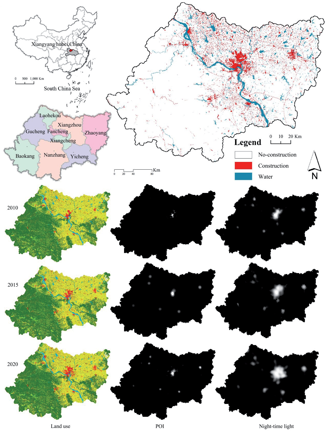
Xiangyang City (32°04’N,112°05’E) is located in the northwest of Hubei Province, China, in the middle reaches of the Han River in the Yangtze River system. There are three counties, three towns, and three cities within its jurisdiction. Xiangyang has various geological and geomorphologic types: the central hinterland is a river alluvial plain. The climate of the region is distinctly seasonal. The main problem in urban development is the imbalance of urban spatial structure and ecological function, during which the urban-rural fringe (URF) is the most prominent contradiction zone. Xiangyang covers an area of 19,727.68 km2 (Fig. 1), accounting for 10.6% of the total area of Hubei Province in China. The current resident population is 5.26 million.
The main data are: 2010, 2015, and 2020 LULC data of Xiangyang city (https://www.resdc.cn) (Fig. 1). Urban population density and distance to main traffic network (http://www.resdc.cn). Night time density(http://data. tpdc.ac.cn). POI density (https://ditu.amap.com. Built-up area density (LULC).
Framework Design
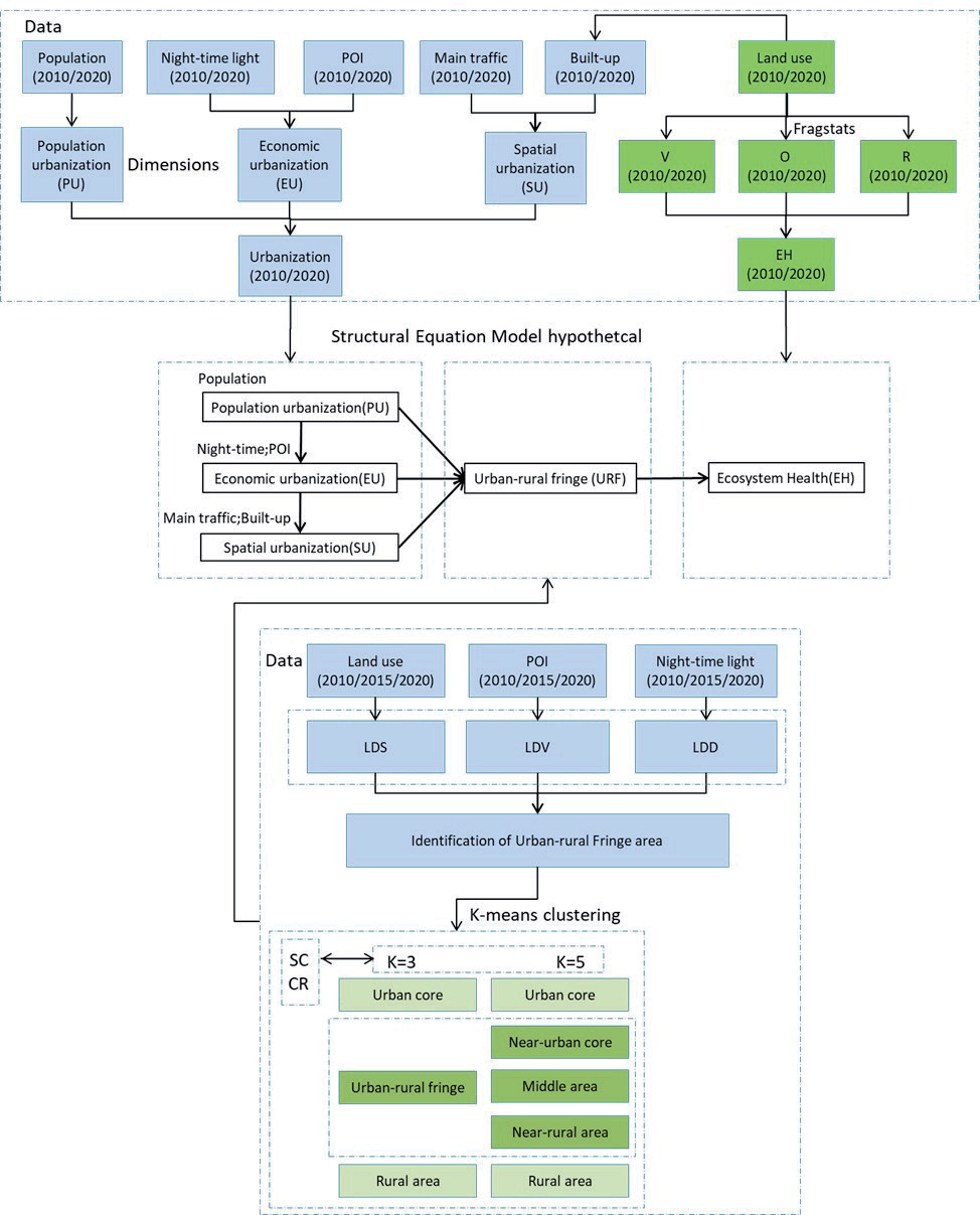
In this study, firstly, based on the three-dimensional index system of land development intensity, the urban-rural fringe was demarcated by the k-means clustering method, the accuracy of clustering and recognition was evaluated using the silhouette coefficient (SC) and consistency ratio (CR), and the appropriate value of K was determined. Finally, the reasonable urban-rural fringe is determined.
Then, a framework is proposed to explore the mediating effect of the urban-rural fringe (URF) in the interaction between urbanization and ecosystem health by introducing the partial least squares structural equation model (PLS-SEM) (Fig. 2). Taking Xiangyang as a case study, using ecosystem health class distribution data, urban-rural fringe class distribution data, population urbanization, economic urbanization, and spatial urbanization data as variables, the PLS-SEM model was constructed, and the hypothesis was put forward:
1. It is assumed that the urban-rural fringe has a mediating effect on the interaction between urbanization and ecosystem health.
2. Suppose there are two mediating effect paths:
a. Population urbanization through economic urbanization and spatial urbanization, taking the urban-rural fringe as an intermediary has an impact on ecosystem health (PU-EU-SU-UR-EH).
b. Population urbanization through economic urbanization, taking the urban-rural fringe as an intermediary has an impact on ecosystem health (PU-EU-UR-EH).
The index load of the variable is then established, and the relationship between exogenous variables (population urbanization, economic urbanization, spatial urbanization, urban-rural fringe grade distribution) and endogenous variables (ecosystem health grade distribution) is assumed as the path coefficient. The mediating effect of urbanization on ecosystem health in the urban-rural fringe was evaluated by using path coefficient and variable loading.
A 1 × 1km window is used to calculate and display the ecosystem health grade distribution, URF grade distribution, population, economic, and spatial urbanization data.
Three Dimensions of Land Development Intensity
With the acceleration of urbanization and rapid expansion of urban areas, there is a significant difference in the intensity of land development when compared with rural areas [40]. With the agglomeration of urban industry and population, the structure and spatial form of urban land use have changed, leading to a significant increase in the compactness of land-use patterns. For a certain amount of construction land, the urban land use pattern is more compact, while the rural land use pattern is more scattered. As far as the urban-rural fringe (URF) is concerned, it combines the characteristics of urban and rural areas. In addition, the economic density of land, the industrial density and the human activity density also decrease gradually along the urban-rural gradient from urban to rural areas. Therefore, the scale (LDS), activity (LDV), and density (LDD) of integrated land development intensity can more comprehensively quantify the difference in land development intensity between urban, URF, and rural areas [15].
In this study, a 1 × 1 km window was used to calculate the scale (LDS), activity (LDV) and density (LDD) of land development intensity.
The first dimension is the scale of land development intensity (LDS), expressed as the proportion of construction land in the assessment unit.
The second dimension is land development vitality (LDV), which is defined as the mean of the POI distribution intensity of a single assessment unit (POI points are converted to distribution intensity by kernel density analysis). The calculation formula is as follows:
Among them
The third dimension is land development density (LDD), which is used as a substitute index of human activity density. Many studies have shown that there is a significant positive correlation between the intensity of socio-economic activities and the brightness of night lights, widely used to identify the spatial extent of urban areas and urban agglomeration [15]. Therefore, it is defined as the mean value of DN distribution intensity of a single evaluation unit. The calculation formula is as follows:
Among them
Identification and Validation of the URF
Herbert Louis divides the URF into three parts in terms of urban form and structure: Old City, early suburbs, and residential areas [41]. We further divided the urban renewal framework into two gradients (K = 3 and 5). When K = 5, the urban-rural gradient of URF is composed of three parts: near-urban core (NUC), middle area (MA), and near-rural area (NRA), which together with urban core (UC) and rural area (RA) constitute the whole city.
In order to comprehensively evaluate the clustering performance of the K value, the silhouette coefficient (SC) was selected as the evaluation index. Silhouette coefficient (SC) represents the degree of closeness and the degree of dispersion between different types of samples after clustering. SC(i) is close to 1, indicating that the clustering of sample i is reasonable; SC(i) is close to 0, indicating that sample i is on the boundary of two groups, and it is generally believed that SC should be better than 0.5. The expression of the silhouette coefficient (SC) index [42] is as follows:
In the formula, SC(i)∈[-1,1]. To assess the accuracy of clustering, we compared urban core areas in 30 * 30 m precision land use data with urban core area data obtained through the clustering method. The formula (5) [43]:
CR represents the consistency ratio between the reference value and the calculated value. Consistency is better when CR is close to 100%.
Ecosystem Health Index Assessment
Based on the vitality-organization-resilience approach proposed by Costanza et al. (1992) [44], we established a framework for EHI assessment:
Among these, Vit, Oit, and Rit refer to three traditional ecosystem indicators; ecosystem vitality, organization, and resilience [43]. We graded the EHI results into five categories.
(1) Ecosystem vitality (EV) is usually defined as net primary productivity.
(2) Ecosystem organization (EO) refers to the stability and complexity of the regional ecosystem structure. For the weights of LH was 0.5 (landscape heterogeneity) and LC (landscape connectivity) was 0.5 [28, 45-47] (Table 1).
Table 1.
Weight of each parameter.
| EO | Weight | Sub-index layer | Weight |
|---|---|---|---|
| LH | 0.5 | MSIDI | 0.25 |
| SHDI | 0.15 | ||
| SHEI | 0.10 | ||
| LC | 0.5 | IJI | 0.25 |
| CONTAG | 0.15 | ||
| DIVISION | 0.10 |
EO formula (Table 1):
(3) Ecosystem resilience (ER) refers to the ability of an ecosystem to maintain its structure. Based on previous studies [46, 48], the formula and its coefficients are as follows:
ER includes “Resil” and “Resist”, “Resil”, gives a weight to resilience (0.6) and a weight to resistance (0.4). (Table 2).
The PLS-SEM Model Specification
PLS-SEM is used for estimating causal networks between latent and apparent variables, typically including measurement models and structural models [49]:
Equations (10) and (11) are exogenous and endogenous indicators, respectively [50]:
PLS-SEM relaxed the multivariate normal distribution assumptions in parameter estimation compared to CB-SEM models [51], suitable for exploratory research [35].
Results
Identification of the Urban-Rural Fringe (URF)
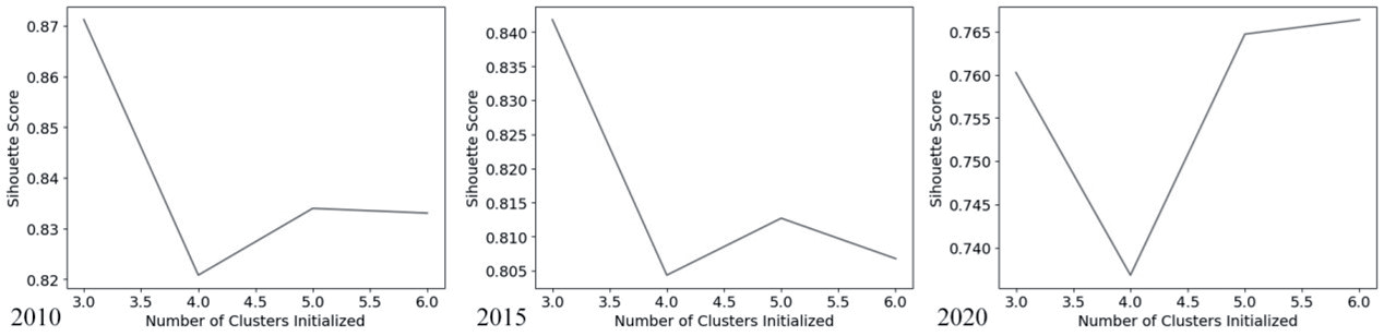
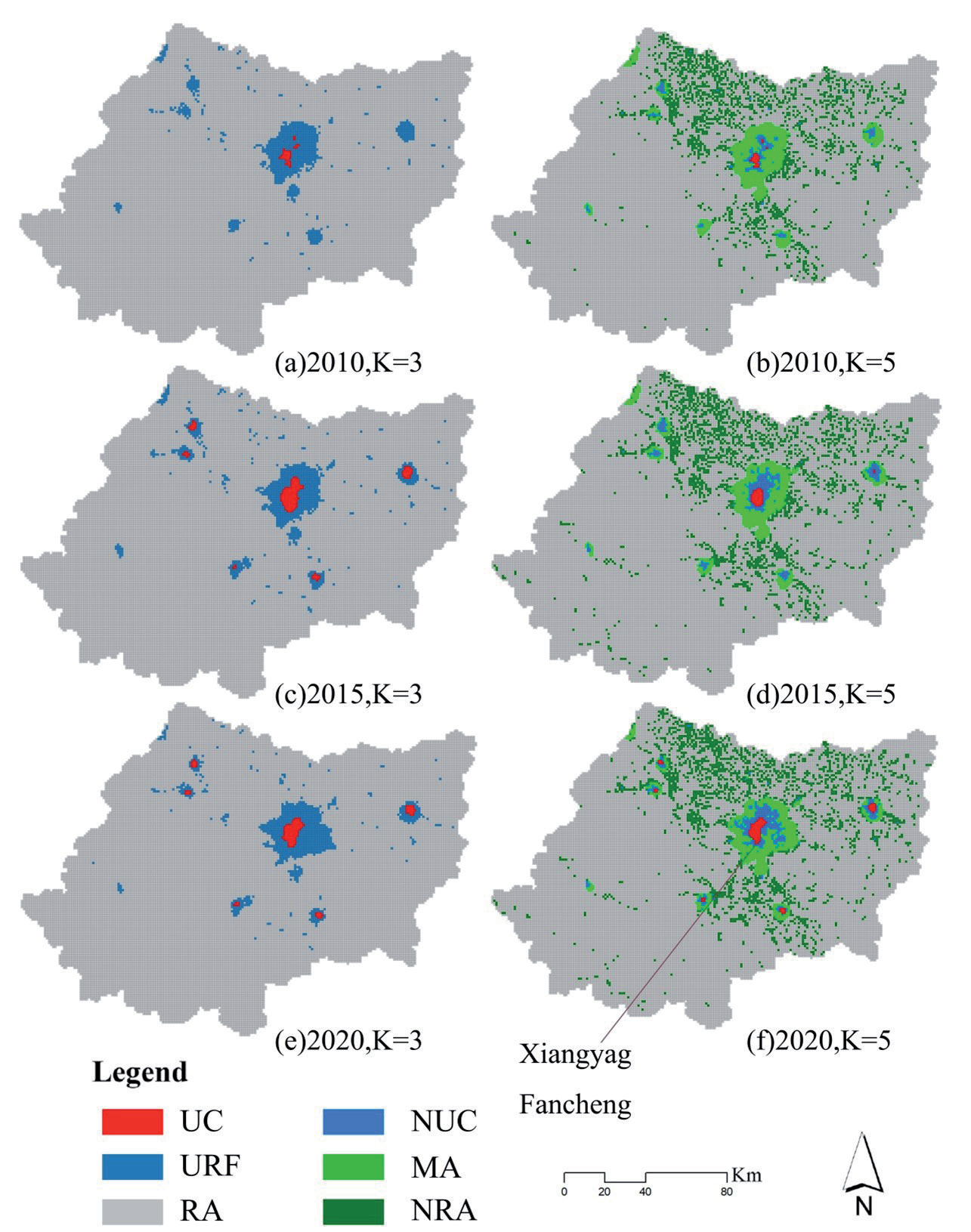
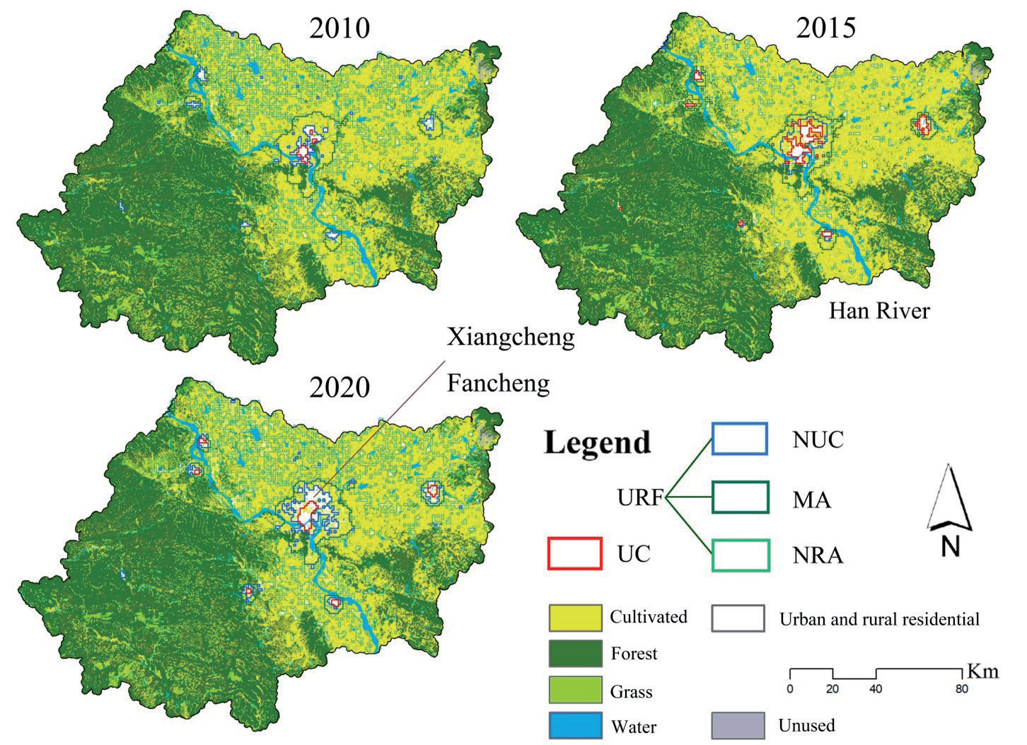
In Fig. 3, the k-value range (3,4,5 and 6) is set in Python and the silhouette coefficient (SC) values for different years are calculated and plotted, with all years having silhouette coefficient (SC) greater than 0.7 and all in the acceptable range. Although the closer the K value is to 1, the better the clustering effect is, considering all the factors, the K value should be chosen 3 and 5 for further discussion. Urban core (UC) and near urban core (NUC) areas are considered as urban core at K = 5. Table 3 shows that consistency ratio (CR) values were above 77% at K = 5, but were less than ideal at K = 3. Therefore, this study is based on the classification of K = 5. Finally, the urban-rural fringe (URF) in 2010, 2015, and 2020 (K = 3 and 5) is obtained, as shown in Fig. 4.
Spatiotemporal Distribution of the URFs Under Different K-Values
Fig. 4 (a)-(f) shows the spatial-temporal distribution of URFs at 3 and 5 K values from 2010 to 2020. Table 3 shows the area change of the sum of UC and NUC at K = 5, with a large increase in the area over 10 years, basically in line with the government statistics, with a CR value of over 77%. It reflects the real situation and trend of urban sprawl. As shown in Fig. 4 (b, d, f), near-urban core (NUC) in Xiangcheng and Fancheng expanded significantly north, west, and east between 2010 and 2020, reflecting rapid urbanization during this period. During this period, the middle area (MA) also expanded to the east, reflecting the rapid growth of the Dongjin development zone. The ring URF becomes thicker. This 10-year urban expansion is mainly from the internal expansion of the development model. The near rural area (NRA) is an area near a rural settlement that has expanded to a certain extent with the construction of a new rural area, as shown in Fig. 4 (b, d, f) and Fig. 5.
Analysis of Temporal and Spatial Characteristics of URF
The land use data of 2010,2015 and 2020 are put under the URF (K = 5) to analyze the spatial-temporal evolution of the urban-rural fringe (URF). It can be found that the development of the urban-rural fringe in Xiangyang is mainly in Xiangcheng and Fancheng (Fig. 5), which has always been the center of Xiangyang. The development of Xiangcheng and Fancheng is mainly to the north and east, especially the Dongjin Development Zone to the east. This is also related to the plain topography of the north, west, and east. Several other cities, especially counties in the western mountainous areas, have not developed significantly. Han River divided Xiangyang in two, with the east developing much more than the west. Urban core (UC) and near-urban core (NUC) almost completely include urban land, urban core (UC) reflects the most core urban area, near urban core (NUC) reflects the area closer to the urban core, middle area (MA) reflects the radiation range of the core area, and near rural area (NRA) reflects the distance from rural settlements. NUC, MA, and NRA constitute a complete urban-rural fringe and reflect the functional orientation of the urban-rural fringe (URF) from different aspects.
EHI distribution in 2010 and 2020.
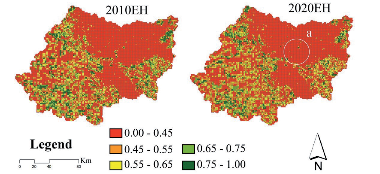
Xiangyang’s EHI changed significantly from 2010 to 2020 (Fig. 6). EHI showed an overall trend of degradation, occurring mainly around cities and along major transportation routes, particularly to the east of Xiangcheng and Fancheng (Fig. 6a). It indicates that urbanization is the main cause of the degradation of EHI. However, the final result of urban expansion will be reflected in the form of the urban-rural fringe. There must be a mediating effect between urbanization and ecosystem health in the urban-rural fringe, but it needs data to verify.
Multicollinearity Test
Variance expansion factor (VIF) was tested by SmartPLS 4 software to detect the multicollinearity of variables (Table 4). Turns out, there is no multicollinearity between the variables [52].
Reliability, Convergence Validity, and Discriminant Validity Analysis Results
Data need to be evaluated for reliability and validity. The reliability, convergence validity, and discriminant validity of the data were analyzed according to the hypothesis model, and Tables 4 and 5 were obtained.
All standardized estimates are greater than 0.47 [53]. All Est./STDE. values are greater than 1.96, and all p-values are less than 0.001, indicating that all items are significant. Item reliability (R-square), greater than 0.36, is acceptable. Component reliability (CR) is greater than 0.5 [54], we say that the CR is acceptable and all the CR is greater than 0.65. AVE, with recommendations greater than 0.5 [55], and the convergence validity of all my dimensions is at the recommended level (Table 4).
All the standard factor loadings were greater than 0.47, our constituent reliability (CR) was greater than 0.65, our convergence validity (AVE) was greater than 0.57, our discriminant validity (Claes Fornell, 1981), and we put the square root of AVE diagonally, the lower triangle is the Pearson correlation of the dimensions, and the comparison results show that our dimensions have discriminant validity (Table 5). The fitness index (SRMR) of the model was tested, and the indexes were in accordance with the recommended value (<0.08). The model was established.
Table 4.
Reliability and convergence validity table.
Table 5.
Reliability, convergence validity, and discriminant validity analysis table.
Research Model Hypothesis Analysis Result
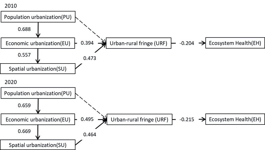
Table 6 and Fig. 7 show the model’s hypothetical results:
(1) The mediating effect of the urban-rural fringe on the interaction between urbanization and ecosystem health is significant (-0.204/-0.214), which is a negative correlation, and the assumption is true.
(2) Suppose that there are two mediating effect paths: a. Population urbanization through economic urbanization and spatial urbanization, taking the urban-rural fringe as an intermediary has an impact on ecosystem health (PU-EU-SU-UR-EH). b. Population urbanization through economic urbanization, taking the urban-rural fringe as an intermediary has an impact on ecosystem health (PU-EU-UR-EH).
Table 6.
Research model hypothesis analysis.
Effects of URF on EHI Distribution
Fig. 7 shows that in 2010-2020, the urban-rural fringe significantly affected the ecosystem health index (-0.204/-0.214), showing a negative correlation, the urban-rural fringe has an obvious mediating effect on the interaction between urbanization and ecosystem health. With the growth of the urban-rural fringe, the ecosystem health index is weakening, and the urban-rural fringe brings negative impacts on ecosystem health, which is increasing with time, this has been demonstrated by many scholars before [48].
Effects of Latent Variables and Manifest Variables on URF Distribution
Fig. 7 shows that economic urbanization (EU) and spatial urbanization (SU) have a direct impact on urban-rural fringe (URF) grade distribution. The direct impact of economic urbanization (EU) and spatial urbanization (SU) changes over time. The direct effect of economic urbanization (EU) on urban-rural fringe (URF) grade distribution increased with time (0.394/0.495). The direct effect of spatial urbanization (SU) on urban-rural fringe (URF) grade distribution decreased with time (0.473/0.464). The original assumption that population urbanization (PU) has a direct impact on urban-rural fringe (URF) grade distribution is not valid.
Population urbanization (PU) and economic urbanization (EU) have indirect effects on urban-rural fringe (URF) grade distribution. The indirect effect of population urbanization (PU) on urban-rural fringe (URF) grade distribution decreased with time (0.688/0.659). The indirect effect of economic urbanization (EU) on urban-rural fringe (URF) grade distribution increased with time (0.557/0.669).
Discussion
Direct Impact of Variables on URF Distribution
Our results show that economic urbanization (EU) and spatial urbanization (SU) have a direct impact on the urban-rural fringe (URF) grade distribution, and their impacts change over time. The influence of economic urbanization (EU), that is, night lighting and POI interest point, is increasing year by year. The traditional spatial urbanization (SU), that is, the influence of urban land use and the main traffic network, is weakening year by year. It shows that the structure of urbanization changes with time, and has a certain impact on the hierarchical distribution of urban-rural fringe (URF), which ultimately affects the hierarchical distribution of the ecosystem health index (EHI), and this trend will become more and more obvious with time.
Indirect Impact of Latent Variables on URF Distribution
Population urbanization (PU) and economic urbanization (EU) have indirect effects on urban-rural fringe (URF) grade distribution. There are two indirect paths: a. Population urbanization affects the grade distribution of the urban-rural fringe through economic urbanization and spatial urbanization (PU-EU-SU-UR). b. Population urbanization affects the grade distribution of the urban-rural fringe through economic urbanization (PU-EU-UR). It can be concluded that population gathering and economic activities are the promoting factors of urbanization and the premise of the formation of urbanization and the urban-rural fringe. The influence of population aggregation is weakening, which may be related to the proportion of labor force and unemployment rate. The influence of economic activities is increasing, which may be related to the improvement of social productivity. These hypotheses need to be confirmed by further research.
The Mediating Effect of Urban-Rural Fringe in the Interaction Between Urbanization and Ecosystem Health
According to the hypothesis, the mediating effect of the urban-rural fringe in the interaction between urbanization and ecosystem health is divided into two lines:
a. Population urbanization through economic urbanization and spatial urbanization, taking the urban-rural fringe as an intermediary has an impact on ecosystem health (PU-EU-SU-UR-EH). It can be understood that population agglomeration promotes the prosperity and development of economic urbanization, and then promotes the development of spatial urbanization, which leads to the formation of the urban-rural fringe, and finally leads to the decrease of ecosystem health index.
b. Population urbanization through economic urbanization, taking the urban-rural fringe as an intermediary has an impact on ecosystem health (PU-EU-UR-EH). It can be understood that population agglomeration promotes the prosperity and development of economic urbanization, which directly leads to the formation of the urban-rural fringe, and finally leads to the decrease of ecosystem health index.
Changes in URFs at Different Stages of Urbanization
The development speed, scale, and form of the urban-rural fringe (URF) vary at different stages of urbanization, and change with the acceleration of urbanization (Fig. 4). The urban-rural fringe (URF) is the forefront space of urban-rural linkage and the ecological barrier of urban-rural integration, and is the area where human land conflicts are most concentrated. The development model of the urban-rural fringe (URF) in Xiangyang city from 2010 to 2020 was identified. The results indicate that Xiangyang has experienced a significant urbanization process in the past 10 years. The urban-rural fringe (URF) mainly presents a significant circular belt with continuous extensional characteristics. The main manifestation of land use structure is obvious ecological degradation. Due to continuous exogenous and endogenous conflicts, spatial structures are becoming increasingly dispersed, complex, and heterogeneous, especially in urban-rural fringe (URF) areas. These changes have significant impacts on policy formulation and urban planning. For the current urban-rural fringe (URF), it is necessary to formulate policies and plans for urban-rural integration and environmental protection and coordinate the relationship between urbanization and ecosystem health. At the same time, it is necessary to simulate and predict the future urban-rural fringe (URF) and formulate corresponding policies and plans in advance to respond to it.
Limitations and Implications
We innovatively propose to explore the relationship and interaction between urbanization and ecosystem health from the perspective of the mediating effect of the URF. This paper focuses on the mediating effect of the urban-rural fringe in the interaction between urbanization and ecosystem health, which provides a new perspective for the study of urbanization and EHI. By constructing the balance system between urbanization and ecosystem health through the intermediary effect of urban-rural fringe, the impact of human activities on ecosystem health can be controlled within a reasonable range, so as to realize the sustainable development of the environment and society.
The reasons for the changes in urban-rural fringe (URF) grade, urbanization, and ecosystem health index (EHI) are often different in different regions, which leads to different mediating effects of URF. Therefore, the framework can be extended to different research areas, aiming at the local level and scale of urbanization development for the development of urbanization, control of urban-rural fringe, and protection of ecosystem health (EH) to provide targeted guidance.
Conclusions
In this study, the PLS-SEM model was used to explore the mediating effect of URF on the interaction between urbanization and ecosystem health, the results:
1. The results of urban-rural fringe delineation are more accurate: the delineated urban core (UC) and near-urban core (NUC) areas are basically consistent with the current urban core areas, and CR values are over 77%.
2. The mediating effect of the urban-rural fringe on the interaction between urbanization and ecosystem health was significant (-0.204/-0.214), which was proved.
3. Suppose there are two mediating effect paths: a. Population urbanization through economic urbanization and spatial urbanization, taking the urban-rural fringe as an intermediary has an impact on ecosystem health (PU-EU-SU-UR-EH). b. Population urbanization through economic urbanization, taking the urban-rural fringe as an intermediary has an impact on ecosystem health (PU-EU-UR-EH).
Recent studies have shown significant spatial heterogeneity in the interaction between urbanization and ecosystem health, with distribution differences in urban-rural gradients [13]. This indirectly proves the mediating effect of the urban-rural fringe (URF) in the interaction between urbanization and ecosystem health. Our research demonstrates the mediating effect and pathway of the urban-rural fringe (URF) in the interaction between urbanization and ecosystem health. The findings of this study can become a key point in the study of the interaction between urbanization and ecosystem health. Future research can continue to explore the formation mechanism of the mediating effect of the urban-rural fringe (URF) by combining the driving factors of their evolution.

