


Introduction
Vegetation is the ecological expression of plants growing together in a given area. The phytosociological characteristics vary according to aspect, location, and even within the same vegetation types. It is a quantitative analysis of vegetation whose main task is to define and classify the vegetation pattern. Vegetation is an ecological attribute of plants growing together in a given area, and the vegetation composition depends on the prevailing climatic and environmental conditions. This explains species diversity, which determines the dispersal of individuals among species in a given area. Vegetation plays a key and important role in the environment’s composition and the global water cycle. It is also influenced by humidity, soil moisture, intensity, and aspects of grazing. Plant communities are collections of functional units of species that vary both temporally and spatially. Changes in community composition are due to seasonal variation and the timing of sampling [1, 2]. The community structure, therefore, reflects seasonal aspects and the key environmental factors affecting community composition, including overgrazing, trampling, deforestation, construction of buildings, soil erosion, natural disasters, and other natural factors. Different environmental factors such as temperature, soil quality, topography, and biotic factors influence plant communities’ composition and distribution patterns. Soil is the key factor determining the specific vegetation characteristics in a given region. Vegetation significantly affects the soil’s physicochemical properties by improving soil structure, water retention, electrical conductivity, and aeration.
A large number of quantitative phytosociological studies have been published in various parts of Pakistan. The vegetation dynamics along an altitudinal gradient in the Terich valley of Chitral were studied by [3]. Researchers have also explored other parts of the district, such as the phytosociology of weeds in wheat fields in Mastuj Valley and Kalash Valley [4]. However, Koh Valley is completely unexplored in terms of vegetation dynamics. Some quantitative phytosociological studies from different parts of Pakistan have already been published, e.g., in [5-15]. In the present research, more data are collected, and recommendations are made for protecting mountain plant biodiversity in a scenario of continuous human use. This site is located in the “ecotone zone” and has unique geographical characteristics, hence a particular type of vegetation pattern. Therefore, this valley occupies an individual transitional position within the region. Environmental planning and management are crucial to maintaining a balance between natural, unmodified, and cultural land use systems. Therefore, the current study in this region was to document the vegetation structure and characteristic species in order to inform future conservation strategies. Action plans and specific management strategies would focus on conserving and restoring vegetation in this unique ecosystem. Here are some important steps and strategies:
a) Establish a list of priority species based on their vulnerability, ecological importance, and conservation status; b) Implement community-based management plans with the participation of local people to ensure sustainable use and preservation of natural resources;
c) Establish seed banks and nurseries for threatened species to support future restoration efforts; d) Educate local people about the ecological importance of Koh Valley vegetation and its role in conserving regional biodiversity.
Materials and Methods
Study Area
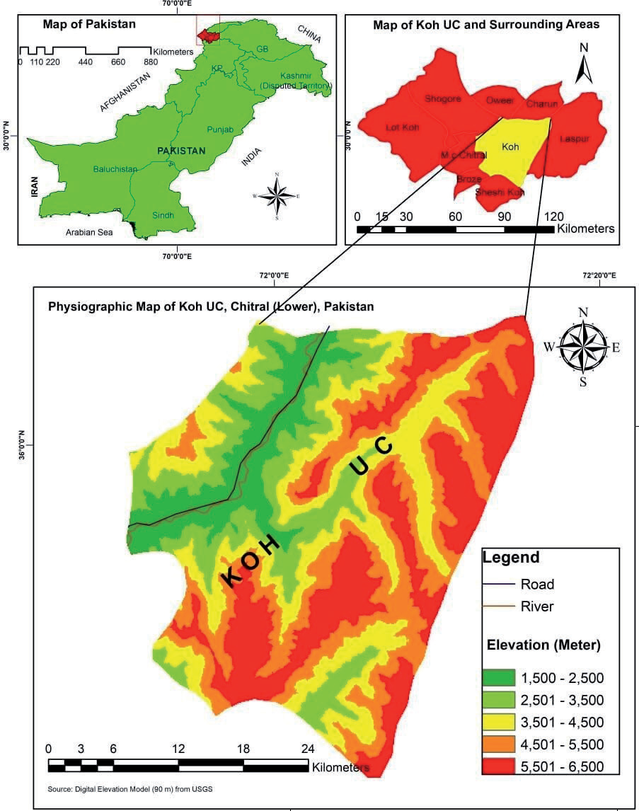
The Koh Valley is steeped in mystique, magic, and beauty, providing a wide range of habitats for wild flora at an altitude that is among the highest regions in the world. This picturesque valley is covered by some of the mightiest glaciers in the world. It lies at 72o07' to 73o97' East longitude and 35o20' to 36o55' North latitude [16]. The valley extends from 1850 m at Kari to 4685 m at Phasti above sea level [17]. It is centrally located in Chitral. Golain and Phasti are sub-valleys of the Koh Valley. It borders Tajikistan to the north, Badakhshan to the west, Nuristan to the south, and the Swat district of Khyber Pukhtunkhwa to the east (Fig. 1). Phytogeographically, the Koh Valley lies in the Irano-Turranian floristic region and is floristically very rich due to its altitudinal variations and landscape features.
Vegetation Structure
The study area was classified into five monitoring sites, namely, Koghuzi, Prayet, Golain, Kuju, and Barenis, based on geographical coordinates, altitude, and aspects for vegetation analysis. The study site was visited regularly from 2020 to 2022 for data collection. It was classified into five ecological zones based on physiognomy, habitat distinction, species composition, and altitudinal variation.
Sampling Units
Various ecological parameters such as density, frequency, and cover were analyzed, and importance values were obtained from these parameters. Based on the values of the highest importance, different plant communities were formed according to the leading species [1, 18]. Quadrates with standard-size plots (1x1 m2) were used for herb communities, 5×5 m2 for shrub communities, and 10×10 m2 for tree communities [19, 20]. Field data on these can describe the vegetation cover of the site, the plants counted, and the species listed. Long, narrow plots usually contain a larger number of species than round or square plots of the same area, as the plants usually grow in clumps, especially when the long axis is parallel to the environmental gradients. The vegetation structure and the phyto-climatic spectrum were analyzed using standard phytosociological techniques [21]. The plant species were identified using the Flora of Pakistan [22] and the World Flora online. Various indices were determined, i.e., similarity index, importance value, Simpson’s diversity index, species richness, and ecological maturity index.
Table 1.
Importance values of the plant species and their executive sites.
Edaphology
Approximately 1 kg of soil samples (to a depth of 15 cm) was taken from each of the five sites in Koh Valley. The collected samples were then mixed into a composite sample, kept in polythene bags, and labeled accordingly for analysis at the research laboratory. The analyses of soil samples were carried out at the Centralized Resource Laboratory (CRL) at the University of Peshawar and the National Institute of Food and Agriculture (NIFA) to determine physico-chemical properties. Soil texture was used to determine the texture classes [20, 23]. Soil pH was determined using a 1:5 soil-water suspension. The organic matter in the soil was quantified according to [24, 25]. The percentage CaCO3 content was determined by acid-based neutralization, according to [26]. The N concentration was estimated using [27], and the Na concentration was analyzed using flame photometry [28]. The K and P content was quantified according to [29]. The macro-micro nutrients of the soils were analyzed with the atomic absorption spectrometer [30].
Results and Discussion
Vegetation Structure
The current study was conducted from 2019-2022 in the Koh Valley of Chitral, Hindukush Mountains, Pakistan. Five monitoring stations were established: Koghuzi, Prayet, Golain, Kuju, and Barenis. The study area has lush vegetation and a distinct vegetation pattern. About 140 plants were identified at the sampling sites. Five communities were identified based on the IV values (Table 1).
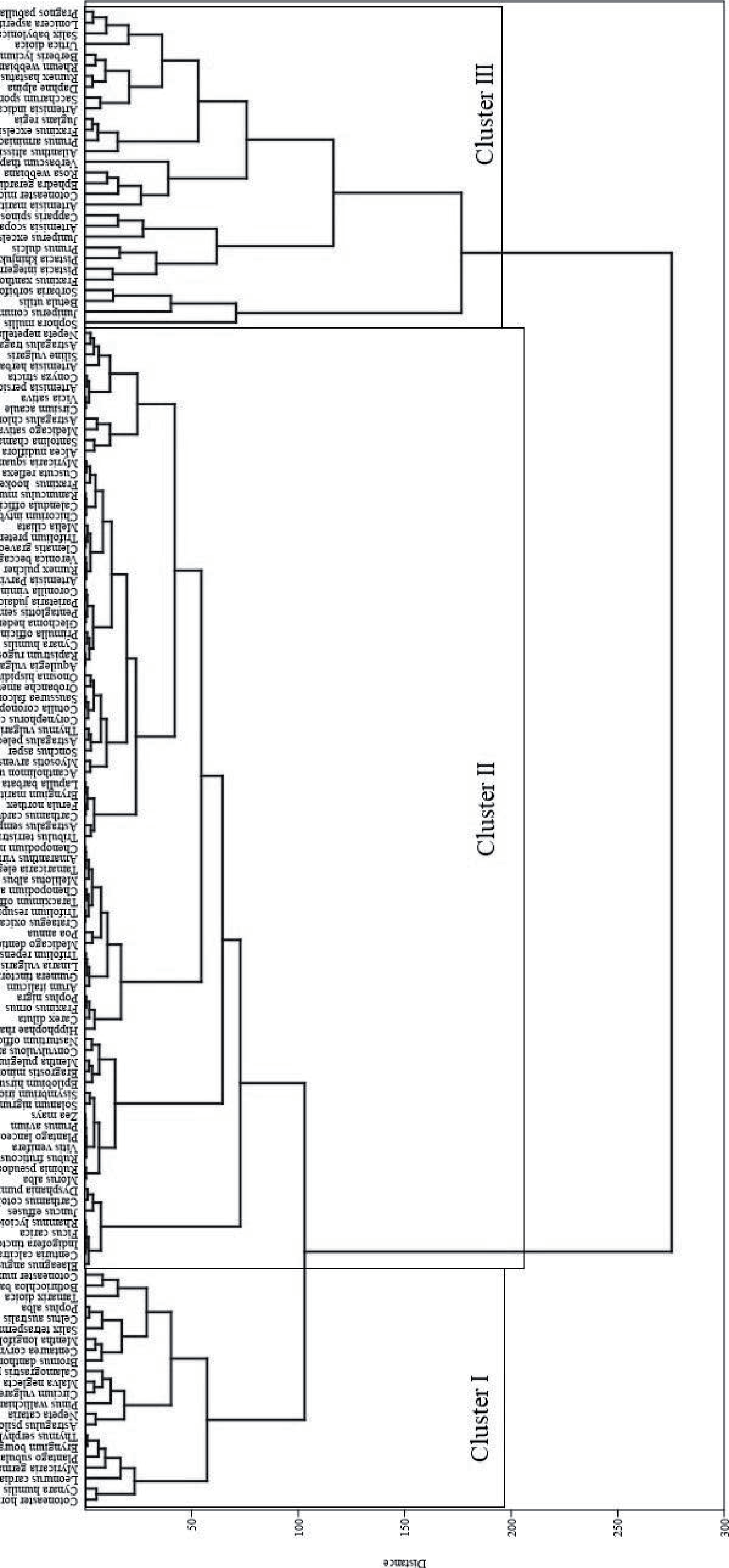
When analyzing the vegetation structure, five plant communities were identified in the Koh Valley. Artemisia-Prangos-Calamogrostis was the community at the Koghuzi site. Artemisia-Prangos-Rheum was found in Prayet. Similarly, the Golain site had Artemisia-Artemisia-Bothriochloa. In Kuju, Artemisia-Rumex-Prangos was the dominant community. The Barenis site, on the other hand, consisted of Artemisia-Prangos-Rheum. In contrast to the manual classification, Ward’s clustering algorithm split the vegetation into three different categories (Fig. 2). The PCA and CCA software techniques were used to link the vegetation numbers to the environmental factors. However, the statistical analysis revealed that the PCA and CCA axes order of stands and plants were essentially associated with the nutrients OM, N, P, and K.
Artemisia-Prangos-Calamogrostis (APC) Community
This was recognized at the Koghuzi site at a 1600- 1800 m altitude with 74 species (Table 1). The leading species in this area were Artemisia maritima (IV. 65.53), Prangos pabularia (IV. 61.03), and Calamograstris pseudophragmites (IV. 55.90). Other dominant plants at this site were Plantago subulata with (IV. 10.41), Nepeta cataria with (IV. 9.16), Thymus serphylum with (IV. 9.15), Cirsium acaule with (IV. 8.85), Rheum webbianum with (IV. 8.51), Malva neglecta with (IV. 8.42), Rumex hastatus with (IV. 7.64), and Artemisia scoparia with (7.33). Some common herbs on the site were Bromus danthoniae, Onosma hispidium, Bothriochloa barbinodis, and Santolina chamaecyparissus. Distribution in the area was clumpy rather than uniform due to the clearing of the plants for fuelwood and overgrazing. The plants with edible fruits and medicinal value showed a high density and an essentially uniform distribution. The present results are consistent with the research work of [1, 2, 6, 31].
Artemisia-Prangos-Rheum (JFS) Community
This community was established at a 1700-1900 m altitude at the Prayet site and included 61 plants (Table 1). The most important plants were Artemisia indica with (IV. 29.09), followed by Prangos pabularia with (IV. 13.87) and Rheum webbianum with (IV. 13.07). Other dominant species at the site were Artemisia scoparia (IV. 13.02), Dysphania pumilio with (IV. 12.54), Rumex hastatus with (IV. 13.05), Astragalus chlorostachys with (IV. 11.20), Juncus effuses with (IV. 10.88), Astragalus psilocentros with (IV. 10.23), Bothriochloa barbinodis with (7.96), and Santolina chamaecyparissus with (IV. 6.42). Other important herbs of the area were Medicago sativa, Cirsium vulgare, and Calamogrostis pseudophragmites. Our results were supported by the work of [32, 33].
Artemisia-Artemisia-Bothriochloa (AAB) Community
This community was found at a 1700-1850 m altitude and comprised 73 plant species (Table 1). It was dominated by Artemisia maritima, with an IV value of 19.43, forming a stable association with the next largest plant, Artemisia indica, with an IV value of 11.30, followed by Bothriochloa barbinodis with 9.53. The other main associated species were Bothriochloa barbinodis with 9.53, followed by Trifolium resupinatum with 8.77, Poa annua with 8.70, Carex diluta with 8.65, Prangos pabularia with 8.12, Astragulus psilocentros with 7.66, and Rheum webbianum with 6.77. Some common herbs on the site were Calamograstris pseudophragmites, Bromus danthoniae, Rumex hastatus, and Chenopodium album. Our results are consistent with the work of [2, 33, 34].
Artemisia-Rumex-Prangos (ARP) Community
This community was studied at the Kuju site at a 1650-1900 m altitude on a northern slope with 56 plant species (Table 1). The leading species was Artemisia maritima, with an IV value of 22.65. Second on the list was Rumex hastatus with 17.41, followed by Prangos pabularia with 15.37. Some other notable plant species in the area were Verbascum thapsus with an IV value of 14.19, Rheum webbianum with 13.44, Saccharum spontaneum with 10.26, Astragulus psilocentros with 10.59, and Cirsium vulgare with 8.98. Some of the notable herbs of the area were Convulvulous arvensis, Cirsium vulgare, Artemisia indica, Centaurea corymbosa, Nepeta cataria, and Solanum nigrum. Our results are consistent with the studies of [2, 6, 32].
Artemisia-Prangos-Rheum (APR) Community
This was found at a1900-2150 m altitude and comprised 73 species (Table 1). The leading plant species in the community was Artemisia maritima with an IV value of 27.10, followed by Prangos pabularia with 18.07, and the strong association of Rheum webbianum with 10.07. Other notable plants of the site were Vicia sativa with an IV value of 9.48, Astragalus chlorostachys with 8.41, Artemisia persica with 7.73, Artemisia indica with 7.85, Artemisia scoparia with 7.55, and Conyza stricta with 6.89 in the Barenis locality. Some notable herbs on the site were Santolina chamaecyparissus, Artemisia indica, Nepeta nepetella, Bromus danthoniae, and Rumex hastatus. Communities of a similar nature have also been noted by many researchers, such as [1, 35, 36].
Diversity Indices
Similarity Index
The congruent natural community of an area and the existing plant community are compared using a measure of similarity. The similarity index was also determined in the present study. According to the current study, there is a similarity of 0.29 % between the APC and APR communities. A similarity of 0.34% was found between APC and AAB. Similarly, the APC community had similarity indices of 0.35 with ARP and 0.37 with the APR community. The APR community had similarities with numerous other communities, including an index of 0.25 with AAB, 0.31 with ARP, and 0.28% with APR. Furthermore, the AAB community has similarities with other communities, including ARP, with an index value of 0.32, and APR, with an index value of 0.31. The community is also similar to the APR community of 0.28 % (Table 2). The high similarity between the communities is due to the nutrient content and proximity of the stands, which had almost similar habitat conditions in terms of N, P, K, pH, soil properties, and composition. The current results agree with the work of [6, 31, 37], who blamed the differences in aspect, elevation, soil erosion, and biotic components of the ecosystem for the alterations between plant communities. During the storm and spring seasons, the high similarity between plant networks is due to the presence of similar shrubs, trees, immortal species, and geophytes, while most of the plant networks are overgrown by therophytes, which have minimal similarities to each other.
Simpson Diversity Index
It is a quantitative measure of the different species in a community. Biodiversity is influenced by many ecosystem living and non-living components, such as altitude, climatic circumstances, soil properties, and anthropogenic and animal activities. Species variety is the most important representation of vegetation dynamics and stands for organization and efficiency. Biodiversity refers to the complexity and efficiency of a community [1, 2, 18]. In the present study, the Simpson diversity of different communities was found to be between 0.16 and 0.28 at different sites. Similarly, the diversity values for sites 3 and 5 were reported to be 0.27 each. Sites 1, 3, and 5 showed the highest values among the other communities with the most similar values. Last but not least, site 2 had a diversity value of 0.19 among the other communities. The lowest value was found at site 4, at 0.16 (Table 3). Similar studies in other regions of the world found that biodiversity mainly depends on soil types, altitude, gradient, and nutrient concentrations [38], and our results are also consistent with the above-mentioned factors from other studies.
Species Richness
It is often used to measure diversity within a single ecological community or ecosystem. It is the result of different living and non-living environmental components and their interactions. In the current study, the highest species richness was found in the Golain and Kuju areas, with 0.18 and 0.17, respectively, followed by Prayet, with 0.16. The lowest values were found in Barenis at 0.13 and in Koghuzi at 0.15 (Table 3). The high value is directly related to satisfactory environmental situations and soil factors. It was explained in [18] that the high species richness in each area could be due to proper habitat and favorable environmental and soil conditions. Differences in altitude and the physiological properties of the soil can also have a strong effect on biodiversity. Under favorable conditions, e.g., in spring, species richness was higher than in the monsoon season due to the dominance of spring annuals and geophytes, which disappear at the beginning of the monsoon season [39]. The low species richness was directly linked to water shortages, high temperatures, overgrazing, and deforestation. Many phytosociological works explained a decline in species richness at high altitudes [34]. These differences were consistent with several other phytosociological research studies in Chitral and other parts of the world [37, 40, 41], which suggested that species richness depends on the range of life forms, species composition, altitude, topography, and orientation.
Fig. 3.
Pca bi-plot showing (a) stands ordination and (b) species ordination along the environmental gradient.
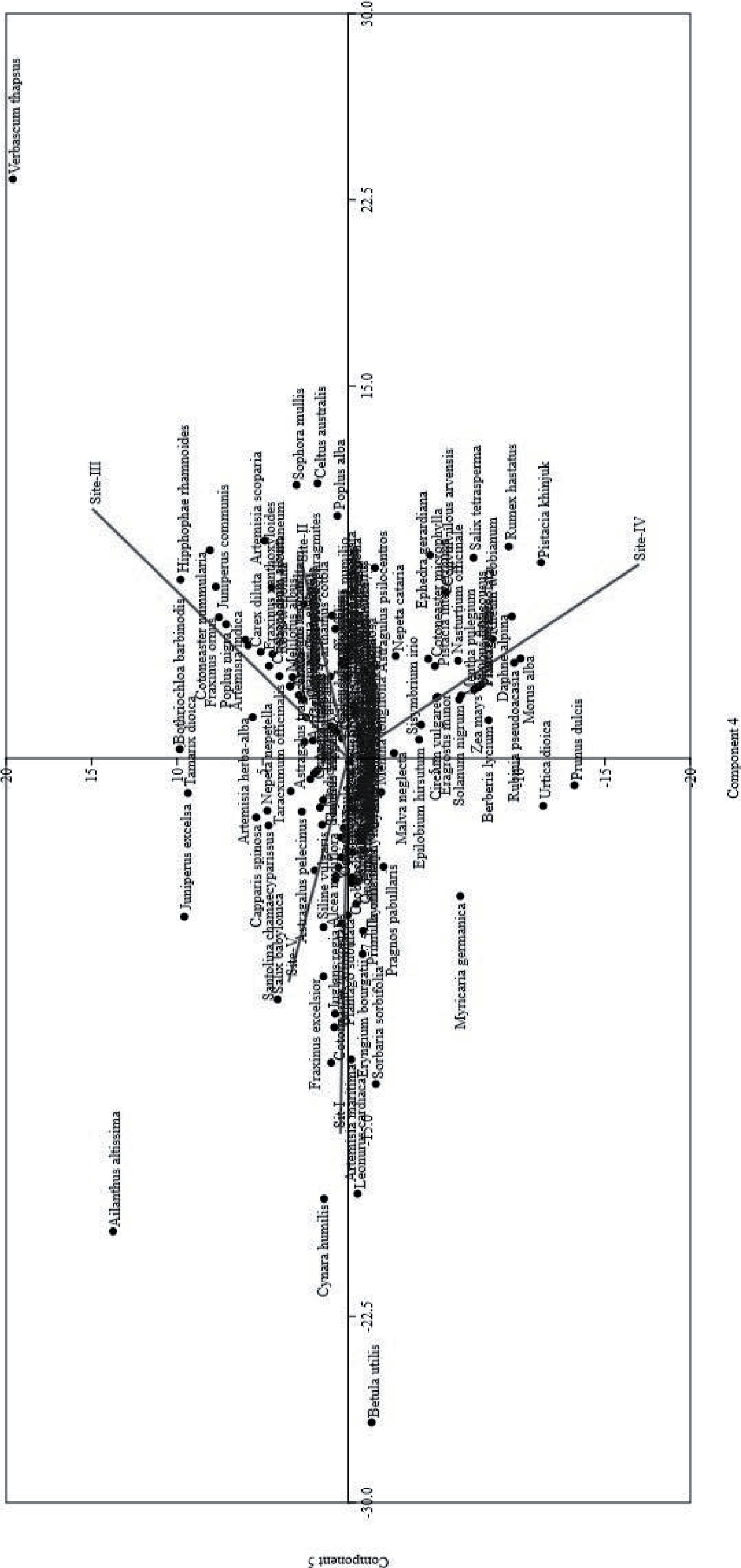
Table 3.
Simpson’s diversity, species richness, and maturity index of different communities.
Ecological Index of Maturity
The developmental process in which plant communities evolve from a young stage to their extreme maturity [1]. It is a new index to assess the vegetation pattern of an area influenced by environmental and edaphic factors. In the present study, the maturity index of the communities ranged from 16.13 at the Koghuzi site to 28.68 at the Prayet site (Table 3). The Golain site had a maturity index of 20.09, and the Kuju site had a maturity index of 26.55. The Barenis site had a maturity score of 23.65 among the other communities. Among the sites, the most similar results between the two communities were found between Kuju and Prayet. Due to less adaptation to microclimate, not all stands were mature. It was also affected by the heavy anthropogenic activities and pressures that disturbed the natural balance of plant habitats and prevented them from reaching maturity. The low level of maturity reflects the variability within the plant communities, which results from the low adaptability to the region’s environmental conditions.
Ordination
Principal Component Analysis (PCA)
It is an exploratory tool for analyzing vegetation data that Pearson first used in vegetation ecology. PCA has been used in several studies in different parts of Pakistan to investigate the relationship between soil properties and vegetation [1, 2]. The ordination method uses principal component analysis to analyze Koh Valley’s spatial variations of vegetation characteristics in Chitral. PCA was performed using CANOCO version 5.0 software, which ordinates the vegetation data on axes 1-2, 1-3, and 2-3 based on the IVs of plant species. The results of the principal component analysis of edaphic data (PCA) are summarized in (Fig. 3). The two-dimensional principal component analysis (PCA) of the edaphic data set shows the distribution of stands on the right side (axes 1 and 2), species in different directions, and edaphic variables in different directions, which shows a significant influence on the vegetation composition of Koh Valley. Siddiqui et al. [42] found a similar substantial association with edaphic variables between the DCA ordination axes. PCA was used to assess the distribution pattern of 140 plant species in 5 stands under the influence of various soil variables. The results clearly showed that the presence of organic matter, phosphorus, potassium, and nitrogen had significant effects on species distribution, diversity, and community classification. Organic matter is the main component of soil that helps to increase biodiversity and provides vital ecological services by improving plant protection and recycling nutrients. The PCA ordering methods for stands and species showed that the first component was mainly correlated with organic matter and nitrogen, while the second component was correlated with phosphorus and potassium. The PCA results showed that both species composition and abundance reflect differences due to soil composition. Furthermore, the results presented in the species ordination diagram confirm the fact that several species had the same composition as seen for the stands. Similar impacts on species composition have been reported from other arid temperate areas of Pakistan [36, 43-45]. Our results, based on multivariate ecological approaches, appear sufficiently robust in this analysis and successfully demonstrate the relationship between vegetation and the environment, especially the distribution patterns of plant communities and individual plant species, despite the long history of anthropogenic disturbance.
Edaphology
Soil is a porous natural body consisting of inorganic and organic substances. The soil is the top fertile layer of the earth, in which living organisms live. Its structure and composition change over time due to the effects of the source materials, the atmosphere, and microorganisms. Soil is formed by continuous processes of physical, chemical, and biological weathering [46]. The soil’s relative proportion of particles of different sizes is called soil texture. The texture, color, and invariability of soil properties play a crucial role in soil nomenclature. Soil texture, electrical conductivity, pH, organic matter, and total dissolved salts are related and determine the vegetation pattern [47]. Dense vegetation patches form on soils with a high organic matter content. Ahmad et al. [48] calculated the concentration of the miracle elements Zn and Fe, where Zn was 1 mg/ kg and Fe was 3 mg/kg, respectively. Fardous et al. [49] investigated the different contents of Co, Mn, and Fe in the soils of rural arable land in Sarghoda for livestock cultivation. They also found the same mineral content in forage crops in the region.
Table 4.
Texture and physio-chemical properties of soil.
Soil Texture
The soil recorded in the research valley was sandy loam and silty loam at all sites. The soils in Koghuzi and Golain were sandy loam, while the other three sites, namely Prayet, Kuju, and Barenis, were silty loam. The concentration of sand and silt was very high compared to clay. The clay concentration was found to be very low. The current study supports this principle, as the soil in Koghuzi has an EC value of 0.17 dsm-1, with 2% clay, 40% silt, and 58% sand. In Prayet, the EC value was 0.13 with 44 sand, 54% silt, and 2% clay particles. In Golain Valley, a value of 0.07 was recorded with 4% clay, 44% silt, and 52% sand particles. In Kuju, 0.12 was recorded, with 0% clay, 52% silt, and 48% sand. Not to mention that the Barenis Valley has 2% clay, 56% silt, and 42% sand particles (Table 4). Our results are in line with those of other researchers who have also studied and elaborated on them [50].
Physico-chemical Properties of Soil
The soil’s nutrient content influences its pH, the solubility of toxic nutrients, and the ability of the soil to exchange cations [47]. The Koh valley is located in the dry temperate zone. Therefore, the soil was alkaline at all sites studied. In Koghuzi, the soil had a pH value of 7.9, in Prayet, 8.1 and in Golain 7.3. The soil of Kuju had a pH value of 7.8. In the Barenis Valley, on the other hand, a soil value of 8.0 was measured. Soil organic matter greatly influences plant growth, and plants thrive better in soils with a higher concentration of organic matter than in soils with lower concentrations. It strongly affects nutrient availability in the soil, soil growth, biological activity, and water storage ability. Pimentel et al. [51] mentioned that organic matter is the main source of nutrients that can contribute to improving the biodiversity of an area and also provides environmental services to the biotic components of the ecosystem. This characterized the fossil formation of plants and animals, soil microbial products, and different stages of their decomposition and development [52]. Koghuzi, Golain, and Barenis soils had the highest organic matter content of 1.04, while Prayet had a value of 0.69. The soil in Kuju had the lowest concentration of 0.55. According to our investigations, the highest concentration (CaCO3) was found in Prayet, followed by 4.25 in Koghuzi. In contrast, a value of 0.5 was recorded at the other three sites (Table 4). Our results on the physico-chemical characteristics of the soil were in agreement with the work of [1, 50].
Macronutrients in the Soil
Macroelements are elements that are utilized by plants in high concentrations and are the main components of tissues and organs of living organisms. They also play an important role in the development, reproduction, and proper functioning of the animal body. It also supports the formation of nodules in legumes [52]. According to our study, Prayet had the greatest concentration of 23.15 mg/kg, followed by Barenis and Kuju with 23.14 and 23.07 mg/kg, respectively. The Golain Valley also had a Ca content of 22.90 mg/kg, but this was slightly lower compared to the other sites mentioned (Table 5).
Magnesium forms the primary central porphyrin ring of chlorophyll and is crucial for photosynthesis. Large amounts of magnesium were also found in our study area; the highest concentration was found in Barenis with 6.517 mg/kg, followed by Prayet with 6.450 mg/kg. The presence of Mg was almost the same in all sites compared to the other elements found in Golain, with 6.378, and in Koghuzi, with 6.364 mg/kg. The lowest concentration was recorded in Kuju Valley, at 6.269. Overall, the values at the sites were above 6 mg/kg compared to other elements, which show large variability. A large amount of it is available in the form of organic resources [2]. Inorganic forms of nitrogen are ionic forms such as nitrite (NO2), nitrate (NO3) and ammonium (H3NO4). The soils of Barenis have the highest nitrogen content, with 0.052 %, followed by the soils of Koghuzi and Golan, with 0.05 each. The Prayet soil sample from Prayet contains 0.034% nitrogen. The lowest nitrogen content of 0.027% was found in Kuju.
Table 5.
Macro and micro-nutrients of sampling sites.
Insufficient K uptake also leads to chlorosis, reduced growth, and a delay in the plant’s ability to mobilize sugars. Plants growing in K-poor soils are susceptible to pests and drought. The K concentration in Koghuzi was 50 mg/kg, the lowest value found in the entire research valley. Prayet had the highest K concentration at 78, whereas Barenis had the second highest at 76. Golain and Kuju had a slightly similar K content, with Kuju having a value of 58 mg/kg and Golain having a value of 56 mg/kg (Table 5). According to [1], phosphorus is present in the soil in much higher concentrations than nitrogen and is largely dependent on weathering, climatic conditions, and soil erosion. Compared to other sites such as Prayet (20.0 mg/kg), Golain (13.7 mg/kg), and Kuju (12.8 mg/kg), the soil of Koghuzi had the highest concentration (22.8 mg/kg), whereas Barenis had the lowest at 7.1 mg/kg.
Micronutrients of the Soil
Although these elements are required in very small quantities for plants, the unavailability of these miracle particles significantly disrupts the normal functioning of plants. These minerals play a crucial role in plant growth’s enzymatic activities and developmental stages. A deficiency or excessive concentration of these trace minerals can lead to harmful physiological disturbances and metabolic malfunctions in living organisms. Overall, all elements were present at all sites in the study area, with the exception of a few sites where some were completely absent (Table 5). Copper promotes the synthesis of proteins and chlorophyll in plants [53]. Our data in the region in question show that Cu was found in four sites, with the exception of Koghuzi, where it was not found at all. Golain Valley had the highest concentration of 0.124 mg/L, followed by Barenis, with a value of 0.105. Prayet and Kuju had extremely low concentrations of 0.066 and 0.061, respectively. The importance of iron in the deposition of lignin and the synthesis of chlorophyll in the plant body cannot be understated. Our results also pointed to the presence of Fe, which had the highest concentration in Koghuzi (21.99 mg/L), followed by Barenis (17.66 mg/L) and Kuju (13.74 mg/L). The other two sites also have iron but in lower quantity than the above: 9.200 in Golain and 7.510 in Prayet, which is the lowest value among the other study sites. Plants growing in Mn-deficient soils exhibit yellowing leaves, veins, and stunted growth. Manganese was found at all four sites except Koghuzi, where the value was 0.00 mg/L. The site with the highest concentration was Barenis, with 4.566, followed by Prayet, with 3.316. The Kuju site was found to have a concentration of 2.900 mg/L. The Golain Valley had the lowest concentration at 1.340 mg/L.
Zinc is a miraculous trace element that plants need in extremely small amounts and that has a variety of functions related to vegetation growth and development. In our study area, it was not present at all in Koghuzi, Prayet, and Golain, while it was present in significant amounts in the Barenis (0.430 mg/L) and Kuju (0.216) areas.
Changes in slope, altitude, geographic location, and community composition were the causes of the remarkable differences in the various metrics across all sites. Our findings are in agreement with the research of [54], who found that vegetation cover, microbiological activity, topography, climate, weathering processes, and soil erosion influence soil physico-chemical parameters. Similarly, our results agree with the research results of [55], which deal with the physico-chemical properties of soil.
Some studies on vegetation structure have been published in different places in Pakistan, including [1- 3, 7, 41, 50, 56]. However, the vegetation structure of Koh Valley in Chitral has not been studied so far. The current research project contributes to the body of knowledge and makes suggestions to protect the biodiversity of alpine plants in case of unending human overexploitation. The valley, which is located in the “ecotone zone”, has special topographical features that give rise to a specific kind of flora. The valley therefore occupies a unique transitional space within the area. In order to maintain a certain degree of preservation, some resemblance of stability between natural, unmodified, and traditional land use systems and some preparation and monitoring of the environment are essential.
The quantitative methods for explaining and verifying vegetation used in this survey not only address procedural limitations and gaps in the literature, such as vegetation grouping and the calculation of ecological gradients, but also lay the groundwork for extending this method to the neighboring mountain system, which requires up-to-date vegetation mapping. Phytosociology is a branch of plant ecology that investigates how different plant species interact in groups. It is a quantitative study of plants to clearly define and classify the vegetation pattern. It is an ecological property of plants that coexist in a particular region, and the prevailing climatic and ecological conditions determine its composition. This explains the species diversity that determines the distribution of individuals in a given region. The vegetation structure has a considerable influence on the composition of the environment and the worldwide water cycle. It is also controlled by humidity, soil humidity, intensity, and grazing characteristics [57]. Plant communities are groupings of useful components of species that exist both temporally and geographically. Seasonal variation and the timing of sampling also contribute to changes in community composition [1, 2]. Community composition thus provides information on seasonal features as well as the major environmental components that affect community structure, such as overgrazing, livestock grazing, deforestation, construction, soil erosion, natural disasters, animal predation, and so on. Similarly, temperature, soil quality, terrain, and biotic variables affect the composition and distribution of plant communities. Soil is the most important component in determining the specific plant characteristics of a region. Vegetation significantly affects soil physiochemical parameters by improving soil structure, water retention, electrical conductivity, and aeration.
Conclusions
This study shows the vegetation dynamics based on 140 sampling units at 5 monitoring sites. The soil analyses included 17 parameters with different properties at each site. The variation in edaphic variables, temperature, humidity, and slope is due to the spatial variation of plant communities at the different monitoring sites. The vegetation in the said valley is endangered, and protective measures are the need of the hour. Vegetation cover is decreasing with each passing day due to anthropogenic activities, overgrazing, natural calamities, and erosion. Local communities’ deforestation of trees in Koh Valley, especially during harsh winters, reduces plant density and increases soil erosion. Fast-growing plant species need to be cultivated to rehabilitate the degraded and fragmented habitat to counteract erosion. A comprehensive program must be developed in collaboration with the local population, conservationists, and governmental and non-governmental organizations to take useful measures for endangered plants and their conservation, focusing on endemic species to reduce their risk of extinction.
Author’s Contributions
Conceptualization, writing - original draft, data curation, methodology, software; ZF, LB, MNK: Visualization, validation, project administration, supervision; ZF, LB, AR, MNK: Methodology, formal analysis, investigation, validation; MNK, AK, ZF, LB Writing - review & editing, resources, software, formal analysis, visualization; ZF, AR, AK, KF, SAR: Writing - review & editing, resources, data curation, funding acquisition; JA, SAR, AK, KF, BMA.

