

Introduction
Currently, the global mangrove ecosystem continues to decline due to land conversion, various development activities, and the transformation of mangrove areas into fishing zones [1, 2]. Generally, the damage to mangrove ecosystems is caused by human activities that exploit natural resources in coastal areas unsustainably, such as tree felling, construction of settlements, well digging, industrial waste, and market waste [3]. Additionally, the low level of community knowledge about the various functions of mangrove forests also contributes to mangrove damage [4]. Coastal muddy land forests (mangroves/brackish) are among the most threatened ecosystems on Earth due to their proximity to the sea (prime resort/development property) and the tendency for residents and governments to overlook their roles [5].
Indonesia is a maritime country with abundant resources, which are distributed both on Land and in coastal and ocean areas. Coastal resources are crucial for the livelihood of the communities living in these areas and for the general population, making the preservation of coastal and marine resources essential for continued prosperity. Supporting the sustainability of these coastal resources require efforts to preserve the ecosystems that sustain them continually, one of which is the mangrove ecosystem. Mangroves are plants that grow on muddy sediments in tidal areas, typically found in tropical regions such as bays and small islands. They are part of areas with complete coastal ecosystems, including coral reefs, seagrass beds, and mangrove forests [6]. Mangroves are ecosystems that form in coastal areas
with an average temperature above 16ºC, brackish water, and unconsolidated soil. They are characterized by the interaction between soil, freshwater, and seawater [7].
Indonesia is the country with the largest mangrove area in the world, with nearly every coastal region in Indonesia featuring a mangrove ecosystem of varying widths [8]. However, rapid development activities in various fields, both physical and economic, have directly and indirectly affected the condition of Indonesia’s mangroves. The mangrove forests are increasingly pressured and diminishing in size, which could gradually lead to a decline in their vital functions both from an economic development perspective and in terms of environmental sustainability [9]. The damage and loss of half of the mangrove areas in Indonesia is largely influenced by human/ anthropogenic activities [10]. Mangrove damage is not only occurring in Indonesia, but in several countries, mangroves are also decreasing, such as in Malaysia. Total mangrove forests in Malaysia have decreased from 648,984 ha in 1990 to 627,567 ha in 2017. Total deforestation reached 21,417ha, or 3.3% with an annual deforestation rate of 793 ha per year or 0.13% per year between 1990 and 2017 [11]. Apart from that, in Thailand, mangroves have decreased due to other land uses, so that by 2014 only 54% of the original mangrove cover remained [12].
West Java Province is one of the provincial regions in Indonesia, featuring a coastline that extends 354 km in the north and 398 km in the south. Particularly, the northern coastal area of West Java serves as a favorable habitat for the growth of mangroves. The distribution of mangroves in the northern coastal region of West Java spans almost all the districts that border directly to the coastline. Based on the results of several previous studies, mangroves in some districts have experienced a decline (deforestation), such as in Muara Gembong Subdistrict, Bekasi District, where between the years 2009 and 2019, there was a mangrove damage covering an area of 275.37 hectares [13]. In Karawang District, specifically in Cilamaya Wetan Subdistrict, in 2019, the total area of mangroves decreased drastically by 50.91 hectares, with Muara Village experiencing the highest reduction of 20.98 hectares [14].
In Indramayu District, there was a change in vegetation density due to several factors, such as the conversion of forest land to fish ponds or natural factors [15]. The condition of the mangrove forests in the coastal area of Cirebon in 2013 had significantly declined compared to 2004 [16].
One of the technologies capable of detecting changes in mangroves, which is widely used today, involves the use of remote sensing technology. This method processes various types of images, from medium to high resolution, to detect changes in both the extent and density of mangroves over a time series. Remote sensing technology is very helpful in detecting time-series changes in mangroves. This aligns with the opinion [17] that remote sensing is a science capable of obtaining information about an object or event on the Earth’s surface, directly recorded through satellites. This study aims to spatially analyze the changes in mangroves that occurred in the North Coast region of West Java Province from 2001 to 2022 and to determine the directions for their rehabilitation. The novelty of this research is that rehabilitation direction is based on physical and environmental conditions and looks at land ownership status as the basis for the rehabilitation strategy.
Material and Methods
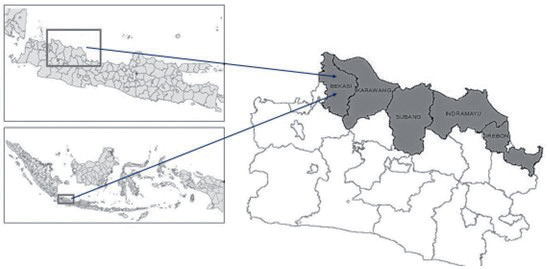
This study was conducted in the northern coastal area of West Java Province, which includes 5 districts directly bordering the coast, namely Bekasi District, Karawang District, Subang District, Indramayu District, and Cirebon District. The Research Location Map is presented in Fig. 1.
The tools used in this research include GPS, tape measure, refractometer, and pH meter. The materials used in this research are the Administrative Map of Regencies/Cities of West Java Province, Administrative Map of West Java Province, Forest Area Map of West Java Province, Landsat Image of 2001, and Landsat Image of 2022. Data collection techniques are carried out by performing image extraction to obtain mangrove images and conducting field ground checks to verify the results of the image interpretation. Data collection techniques for physical aspects involve direct measurements in the field in areas requiring rehabilitation.
Measurements of mangrove density and types are carried out using the line transect technique with dimensions of 10 x 10 m. A more detailed illustration of the line transect is presented in Fig. 2.
Sampling of substrates is carried out by taking substrate samples, pH measurement is conducted by direct measurement with a pH meter, and salinity is determined directly using a refractometer. Data on current Speed and tidal variations are obtained from the Agency for Climatology, Meteorology, and Geophysics.
The data analysis technique for mangrove changes is conducted using an overlay technique between the mangrove data from 2001 and 2022, thereby identifying changes in mangrove cover within the research area. This analysis is primarily aimed at observing changes in mangrove land cover using multitemporal data, comparing two images/classification results. By merging the land cover classifications from 2001 and 2022, changes in mangrove land cover can be identified. The extent and changes can be calculated from the number of pixels using the formula:
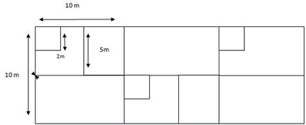
Table 1.
Matrix of Land Suitability for Mangrove Rehabilitation [18].
Where ΔL is the rate of change in the area, Lt1 is the area in the initial observation year (ha), and Lt2 is the area in the subsequent observation year (ha). ∆t is the time difference between the initial observation year and the final observation year (years).
Land suitability analysis for mangrove rehabilitation is conducted to determine the suitability of the land for mangrove rehabilitation. The reference for the land suitability analysis for mangroves is based on the land suitability criteria matrix for mangrove rehabilitation, as shown in Table 1.
Technical instructions for mangrove rehabilitation are carried out by observing the land use conditions in the field and the status of land ownership. After determining the land suitability level at the location, it is necessary to decide which mangrove species are suitable to be planted there based on the physical and environmental conditions in that area. The guidance on the type of mangrove to be planted uses a reference matrix, as shown in Table 2.
Results and Discussion
Distribution of Mangroves in the Coastal Areas of West Java in 2001 and 2022
Based on the analysis of imagery and field ground checks conducted, the distribution of mangroves in the coastal areas of West Java are almost spread throughout all districts that directly border the coast, including Bekasi District, Karawang District, Subang District, Indramayu District, and Cirebon District. The detailed distribution of mangroves in the coastal areas of West Java Province is presented in Fig. 3.
Based on Fig. 3, it is observed that in 2001, the mangrove coverage was 1,616.35 hectares, which increased to 3,122.56 hectares by 2022. In 2001, the largest mangrove area was located in Indramayu Regency, and by 2022, Indramayu still had the largest mangrove coverage in West Java Province. From 2001 to 2022, there was an increase in mangrove coverage across all the coastal regencies of West Java Province.
More detailed information on the mangrove coverage of each coastal regency in West Java Province is presented in Fig. 4.
From Fig. 4, the mangrove area in West Java has mostly increased. However, a more detailed look at the district level reveals that several districts have experienced deforestation or a decrease, as further detailed in Table 3.
Types and Density of Mangroves in the Coastal Areas of West Java Province Based on observations conducted, eight types of mangroves are found in the coastal areas of West Java. These types are found almost throughout the entire coastal region. More detailed information on the types of mangroves observed can be seen in Table 4.
Based on Table 4, it is evident that the variety of mangrove species in the coastal areas of West Java Province is diverse. However, according to the observations conducted, the most dominant vegetation types are Rhizophora and Avicennia. This prevalence occurs because these types of vegetation are easy to grow, and they are predominantly the species planted in mangrove cultivation activities by both the government and the community.
In Bekasi Regency, based on the results of observations, there are 6 types of mangroves spread across the area. This is different from the results of research [20]. Based on the results of this research, there are 7 types of mangroves with the following species; Avicennia alba, Avicennia marina, Aviennia officinalis, Rhizophora apiculata, Rhizophora mucronata , Nypa fructicans, Sonneratia caseolaris, Sonneratia alba, Bruguiera gymnorrhiza, Aegiceras corniculatum, Excoecaria agallocha, and Acrostichum aureum. In Karawang Regency, there are 4 types of mangroves, namely Avicennia marina, Rhizophora apiculata, Rhizophora mucronata, Soneratia alba, and Soneratia caseolaris. In Subang Regency, there are 3 types of mangroves, including Avicennia marina, Rhizophora mucronata, and Soneratia caseolaris. This is different from previous research conducted by [21]. According to this research, there are only 2 types of mangroves in Subang Regency, specifically in Ciasem District, namely Rhizophora sp. and Avicennia sp. In Indramayu Regency, there are 8 types of mangroves, including Avicennia marina, Rhizophora mucronate, Rhizophora stylosa, Avicennia alba, Soneratia c aseolaris, Bruguiera gymnorrhiza, Soneratia alba, and Nypa fruticans. In Cirebon Regency, mangroves are spread almost throughout the coast and in residential pond areas.
Table 2.
List of species for mangrove ecosystem rehabilitation and characteristics of their growing places [19].
Based on observations, there are 7 types of mangroves, namely Rhizophora mucronata, Rhizophora apiculata, Avicennia marina, Avicennia alba, Bruguiera gymnorrhiza, Soneratia caseolaris, and Nypa fruticans.
This is mainly due to the easier availability of Rhizophora sp., and Avicennia sp., seedlings compared to other types. The distribution of mangroves in the coastal region of West Java falls into three categories: those along the coastline, along riverbanks and estuaries, and in the ditches of community fishponds. Mangroves located at the edge of community fishponds thrive, as the majority of the coastal communities in West Java adopt a silver aquaculture system. Silvo-aquaculture is a method of brackish water fish farming combined with the maintenance of mangroves and is considered the best approach for mangrove conservation. Mangroves support fish farming and production in silver-aquaculture fishponds by preventing pond damage from wind, tidal movements, and waves, treating water quality from pollutants, providing plankton as a supplementary feed, and supplying nutrients for pond fertility [22]. The density of mangrove vegetation in the study area, as measured through transect line methods, predominantly ranges between 10-20 trees per hectare.
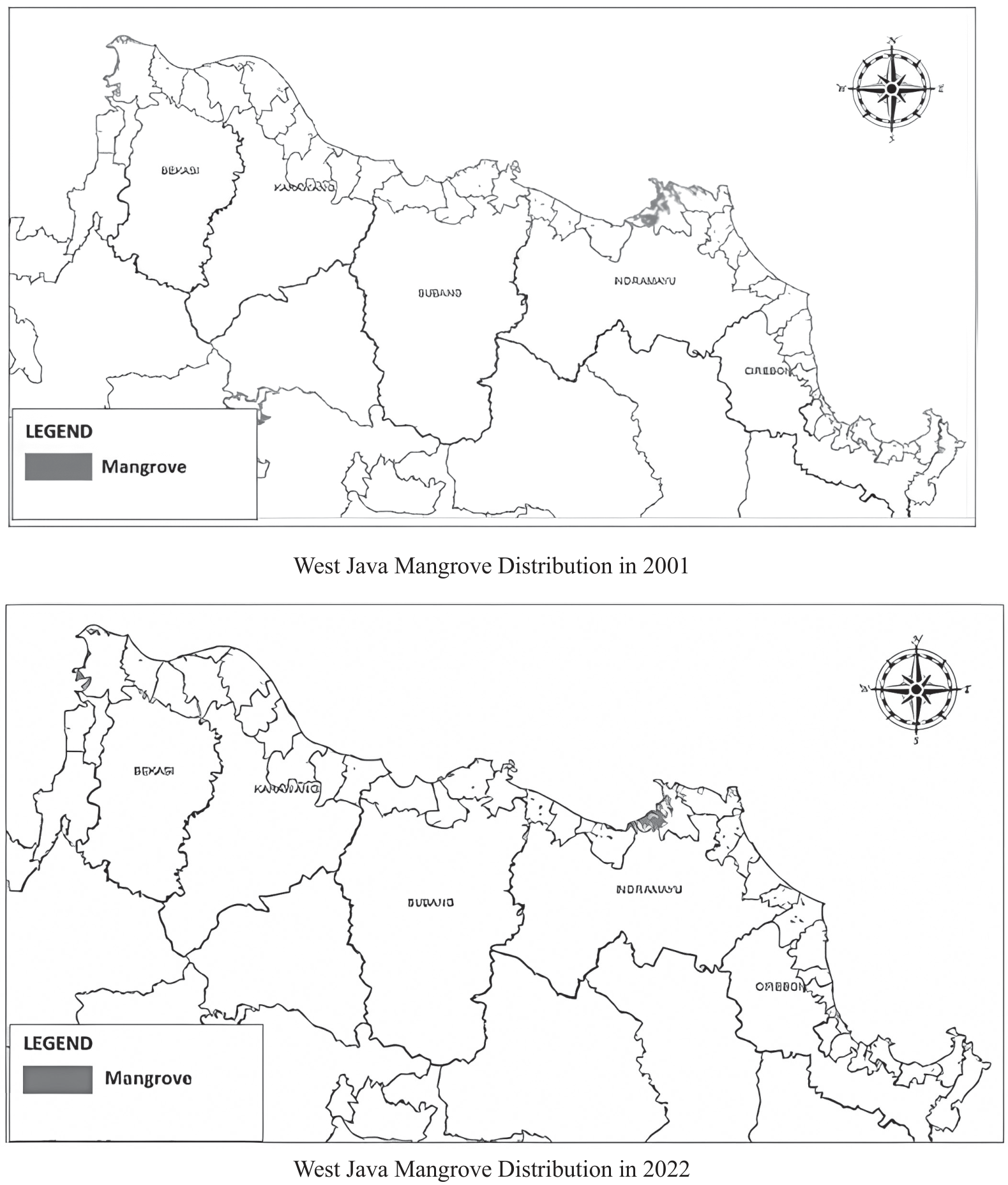
Table 3.
Districts with Deforestation from 2001-2022.
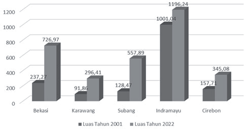
Table 4.
Types of Mangroves in the North Coastal Region of West Java Province.
Oceanographic Conditions of the West Java Coastal Region
Tides
Tides are the fluctuations of sea level due to the gravitational pull of celestial bodies, particularly the sun and the moon, on the ocean’s water mass on Earth. The tide type on the north coast of West Java falls under the mixed tide prevailing diurnal category. In this type, there is one high tide and one low tide per day, but occasionally, for some time, there are two high tides and two low tides with very different heights and periods [23]. The waters of Indramayu experience one high tide and one low tide (diurnal), but at other times, two high tides and two low tides also occur [24].
Salinity
Salinity is the level of saltiness in seawater, and it serves as one of the quality parameters for a water body. Salinity is a critical factor to consider in the life of coastal ecosystems, where varying concentrations of salinity can significantly impact the breeding of fish inhabiting these waters. Thus, the concentration of salinity needs to be calculated and considered when managing coastal areas [25-27]. High salinity levels also have economic impacts on coastal communities; for example, high salt levels can be utilized for salt farming [28]. Salinity refers to the salt content in water bodies that can determine the life of mangrove ecosystems [29].
According to data from the Meteorology, Climatology, and Geophysics Agency, the salinity levels in the northern coastal region of West Java range from 30 to 36 ppt. This indicates that salinity in the northern coast of Java is complex, ranging from low to high levels.
Current Velocity
Currents are movements of water that result in the horizontal and vertical displacement of water masses. This allows for the occurrence of various water-related phenomena [30]. The term “current” generally refers to the advection of water in surface flows. Being a vector quantity, currents are expressed in terms of Speed and Direction in polar notation or as Cartesian terms as components from an absolute spatial reference with respect to time [31].
The Speed of the currents affects the growth of mangroves, especially when the mangroves are still in the form of seedlings from rehabilitation efforts; thus, current Speed is a constraint on the growth of young mangroves. However, once the mangroves are large and dense, the Speed of the currents can be dampened by the mangrove ecosystem. Therefore, when rehabilitating mangroves, it is necessary to adjust the planting techniques to the current speed conditions at the location where the rehabilitation will take place.
Substrate Type
The particle size of a beach’s substrate is influenced by several factors, including the magnitude of incoming waves and currents and runoff supplying sediment from land.
Relatively calm waves and currents cause finer particles to be deposited first, followed by medium to coarse sediments [9]. In mangrove ecosystems, there is a close relationship between sedimentation and hydrodynamics. This means that the movement of soil and water are intricately linked and occur simultaneously. Tidal currents and waves carry sediment to sediment deposits, while complex wave motions, on the other hand, can cause sediment among roots to be remobilized by water [32]. Sheltered beaches with mud deposits located between the average sea level and high tide are favorable environments for the growth and development of mangroves [33]. Field observations at several points in the northern coastal region of West Java Province have identified types of substrates, including silty sand, sandy mud, and sand.
Suitability of Land for Mangrove Rehabilitation
The numerous mangrove planting activities reported by various mass media in different regions of Indonesia illustrate the importance of the mangrove ecosystem in coastal areas as a natural resource that needs to be preserved as a coastal defense system. This is recognized by many in Indonesia. However, this awareness is not matched by an increased understanding of the characteristics of mangrove plants, particularly regarding the environmental conditions required for their growth [33]. For successful mangrove planting, it is crucial first to understand the growth characteristics and distribution of mangroves, as well as various supporting physical factors. Efforts to plant mangroves in a region require standards that can depict whether an area is suitable for mangrove cultivation or not [34]. Several factors influence the success of rehabilitation; among them are environmental factors, especially site conditions, and hydrology [35-37]. Based on the analysis of data from observations and field measurements that have been conducted, the majority of the land requiring rehabilitation falls into the categories of highly suitable, suitable, and conditionally suitable for mangrove rehabilitation. More details can be seen in Table 5.
Mangrove Rehabilitation Guidelines Mangrove rehabilitation is one of the solutions to restore damaged ecosystems. The direction of mangrove rehabilitation is carried out in areas where, based on image analysis results, deforestation has occurred. The approach to mangrove rehabilitation involves considering the existing field conditions and the status of land ownership. Mangrove rehabilitation is an effort to recover and recreate mangrove ecosystems that have been damaged and whose functions have declined, restoring them to stability [38]. The mangrove rehabilitation program must be conducted with thorough planning and implementation and should not overlook ecological aspects [39].
Additionally, the social aspects of the community must also be considered, as the success of rehabilitation depends not only on physical (ecological) aspects but is also greatly influenced by the social aspects of the local community. Rehabilitation activities have been carried out in several areas, yet they have not shown satisfactory results due to the improper choice of coastal land rehabilitation technology, especially concerning the conditions of biophysical elements [40], water management, and the level of damage. This rehabilitation program is expected to cover not just physical targets and budgets but also to be directed towards achieving benefits for the environment, both biophysically and socially, as well as institutional roles. The areas that need rehabilitation are those where deforestation has occurred; more details are presented in Fig. 5.
Table 5.
Land Suitability for Mangrove Rehabilitation.
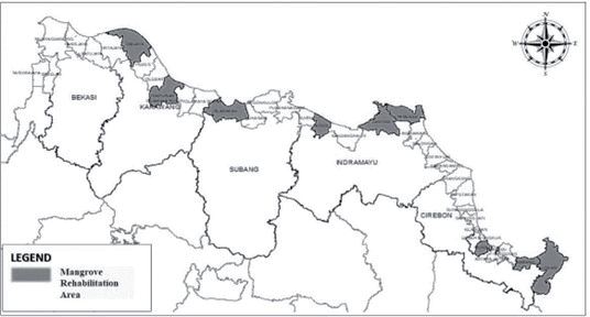
Table 6.
Mangrove Species Recommendations Based on Physical Conditions of Locations.
According to Table 6, in regions requiring rehabilitation, the suitable species to be planted can be categorized into two groups. The first classification is characterized by locations with deep mud, with some areas along the riverbanks, as well as dry, estuarine areas with sandy mud to clay, with low to high salinity. The recommended mangrove species include Avicennia sp., Rhizophora sp., Sonneratia sp., and Nypa fruticans. The second classification is in the Patrol region of Indramayu County and Cibuaya of Karawang County, characterized by riverbanks and dry areas with low to high salinity and sandy soil. The recommended mangrove species here are Avicennia sp. and Rhizophora sp., aligning with the findings of research [41], which suggests that based on physical environmental factors, A. marina, S. alba, R. mucronata, R. apiculata, and associated mangrove species are recommended for rehabilitation activities.
Technical guidelines for mangrove planting should be determined to ensure optimal survival rates during mangrove planting activities. The mangrove planting zones, designed to prevent land and coastal environmental damage can be detailedly divided into four zones, each distinguished by the type of mangroves planted:
a. Green Belt Area;
Planting of the mangrove species Avicennia sp. (api-api) is necessary here, as this pioneer species thrives in coastal areas. The creation of this green belt should be categorized as ‘immediate’, taking into account the location and rate of abrasion, and prioritized for the prevention of abrasion rates.
b. River Channel Area;
In this zone, it is essential to plant the Rhizophora sp. mangrove species, given that its roots can prevent riverbank erosion and are also beneficial for filtering water entering aquaculture areas.
c. Aquaculture Area;
Species such as Rhizophora or Avicennia sp. (api-api) should be planted here, which is very beneficial for the aquaculture environment. The mangrove roots increase the oxygen levels in the aquaculture water, which is essential for fish and shrimp growth.
Additionally, the fallen leaves of the Avicennia sp. (api-api) mangroves are decomposed by microbes and serve as excellent organic feed for shrimp and fish.
d. Aquaculture and Rice Field Border Area;
To prevent seawater intrusion into rice farming land, planting the mangrove species Bruguiera gymnorhiza (Panjang) is necessary. Thriving in clay and slightly compact soils, this species grows well. Additionally, mangrove trees absorb and reduce water salinity, serving as excellent boundary trees between aquaculture and rice fields. The ecological thickness of mangroves in this area should be adjusted based on the land conditions [42].
Based on the conditions of land ownership and the existing conditions of land use, the technical directions for mangrove rehabilitation can be classified into two categories: silvofishery techniques and the creation of green belt areas. More details on the technical directions for mangrove planting can be seen in Table 7.
In addition to determining planting techniques, the selection of mangrove seedlings is also a crucial factor in the success of mangrove rehabilitation. It is advisable to avoid selecting seedlings that have grown from the fallen seeds of the parent tree, as transferring mangrove seedlings from their growing habitat poses risks to their survival rate. Therefore, special seeds, namely seedlings from nurseries, are required for the mangrove rehabilitation process in coastal areas [43]. Moreover, mangrove planting can generally be done in two ways: direct planting of mangrove fruits (with a success rate of about 20-30%) and through seedling nurseries (with a success rate of about 60-80%) [44].
Table 7.
Technical Guidelines for Mangrove Rehabilitation.
Conclusions
Based on the results of the analysis, it can be concluded that the spread of mangroves in the North Coast region of West Java Province from 2001 to 2022 has increased overall. However, 9 sub-districts in the district have experienced deforestation and require rehabilitation efforts.
The land suitability analysis for mangrove rehabilitation in these 9 sub-districts resulted in three categories: highly suitable, suitable, and conditionally suitable. Technical guidance for rehabilitation based on the existing land conditions and land ownership status on aquaculture land is conducted using the silvofishery system. Meanwhile, along the riverbanks, the formation of a green belt is directed, and in residential areas, if feasible, planting is directed at settlements directly bordering the beach or aquaculture ponds. On the coastal fringes, it is directed to remain as a greenbelt area ranging from 52 to 702 meters perpendicular to the coastline or riverbank.

