

Introduction
Since the 21st century, rapid urban population growth has made land resources increasingly scarce, with significant encroachment on blue and green spaces, leading to an imbalance between urban ecology and construction [1, 2]. In this context, urban parks, as a key component of urban blue-green spaces, have garnered significant attention for their ability to enhance the urban ecological environment, improve people's quality of life, and foster a sense of well-being [3-5]. They provide essential ecological and social benefits, supporting sustainable urban development [6-9]. As urban park development progresses, its benefits have been widely discussed [10, 11]. Overemphasis on social benefits can diminish parks’ ecological potential [12], while focusing solely on ecological benefits can reduce public engagement and urban vitality [13], undermining the sustainable development of parks. Urban parks’ benefits integrate both ecological and social aspects [14, 15], necessitating a comprehensive consideration in planning and construction. However, current practices usually neglect the balanced development of ecology and society [16], reducing the benefits of parks. Therefore, exploring ways to maximize the integrated benefits of urban parks is crucial for high-quality urban development.
Although studies have evaluated urban park benefits, such as Brown et al. [14], employed participatory mapping methods to assess park benefits across environmental, social, and psychological dimensions and analyzed the relationship between benefits and park type, size, and location, there is a lack of quantitative research. How to enhance the benefits of urban parks remains a key unresolved issue. Related research on benefit enhancement mostly focuses on land use pattern optimization, simulating different land use scenarios based on the equilibrium relationship between ecological and social benefits [17-20]. For instance, Li et al. [17] identified the scenario that maximizes both ecological and economic benefits as the future urban land use optimization plan, showing the direct impact of land use on regional benefits and emphasizing the importance of integrated benefit enhancement. Urban parks usually comprise various land use types such as green spaces, water bodies, and construction land [12]. Therefore, optimizing land use patterns is an effective method for enhancing the integrated benefits of urban parks.
Research shows that parks with water bodies not only have superior cooling and humidifying functions [21] but are also more attractive to visitors [22]. In these parks, water bodies are crucial components of the landscape structure, and the ratio of water to land directly affects the park’s land use pattern. Therefore, different water surface ratios can yield various benefits [23]. Suitable water surfaces serve essential ecological functions and are vital parameters for ensuring societal and economic sustainability [24]. Thus, determining the suitable water surface ratio for urban parks is vital for enhancing park benefits, though research in this area is currently lacking. The concept of suitable water surface ratio was initially proposed by Wang and Wang [25] in the context of environmental concerns, attracting considerable scholarly attention. Presently, most existing research focuses on determining the suitable water surface ratio based on urban drainage and flood control requirements [26], without considering comprehensive ecological and social benefits. Major research methods include multi-object multi-level fuzzy evaluation models [24], mathematical models [27, 28], and the factor-weighted average method [29]. These methods often require complex data inputs, making data collection difficult and unsuitable for urban park studies. Therefore, it is feasible to determine the suitable water surface ratio of urban parks by integrating ecological and social factors from a land use perspective, effectively enhancing the comprehensive benefits of parks.
In summary, this study aimed to determine the suitable water surface ratio for urban parks to maximize integrated eco-social benefits. Specifically, we sought to address the following questions: (1) How do different water surface ratios influence the ecological and social benefits of urban parks? (2) How do different water surface ratios impact the integrated eco-social benefits of urban parks? (3) Is there an optimal water surface ratio that maximizes a park’s comprehensive benefits? To answer these questions, we proposed a method for identifying the suitable water surface ratio for urban parks. Using Dashengguan Park in Nanjing as a case study, we comprehensively considered the park’s ecological and social development needs and constructed models for ecological and social benefit indicators based on land use types. Finally, we calculated and compared the integrated eco-social benefits of different water surface ratios and identified the suitable ratio that maximizes the park’s integrated benefits. The findings aim to offer a new insight into urban park planning and construction.
Material and Methods
Study Area
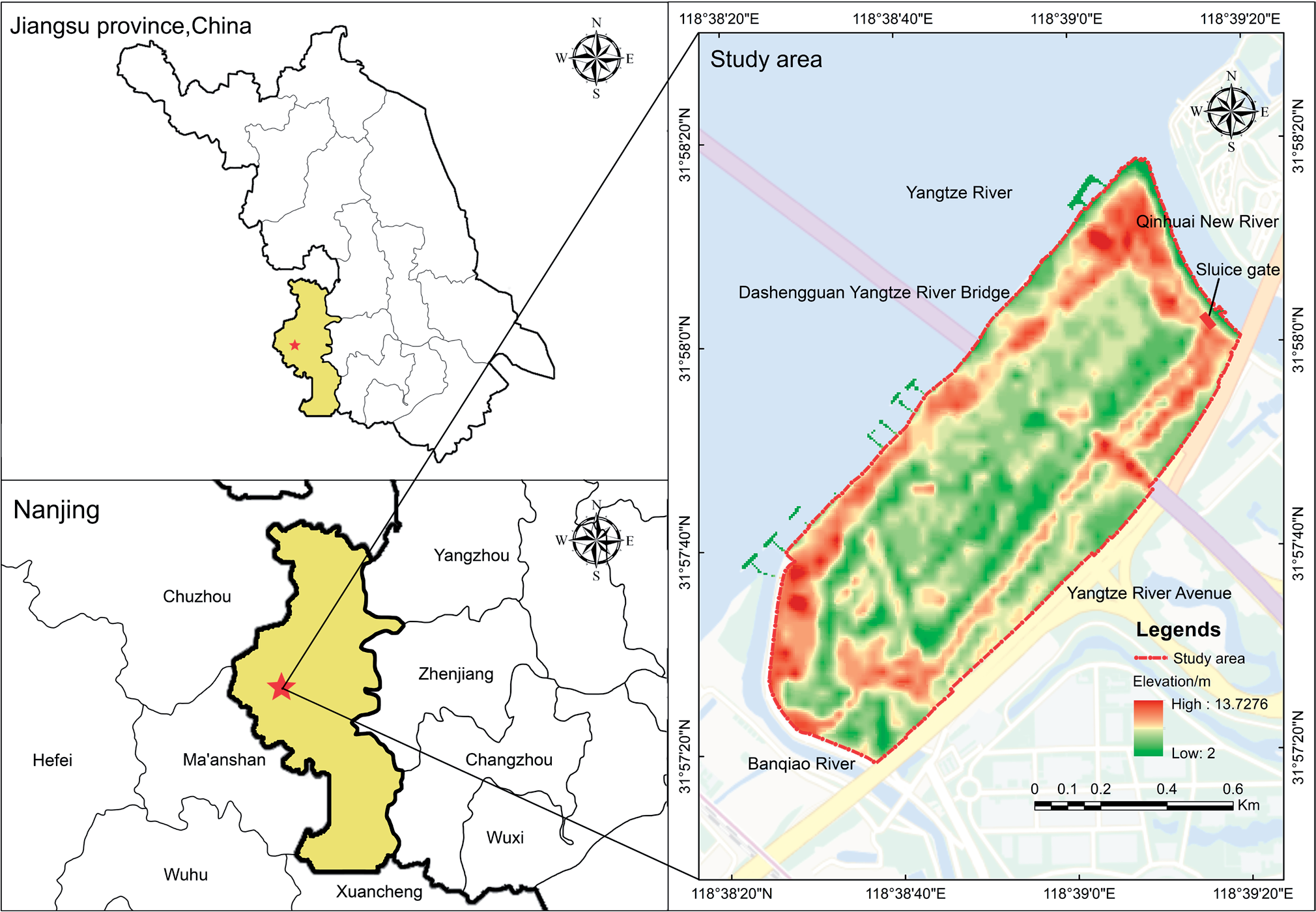
Dashengguan Park is situated in the Yuhuatai District of Nanjing City, Jiangsu Province (see Fig. 1), enveloped by water on three sides: the Yangtze River to the west, the Banqiao River to the south, and the Qinhuai New River to the north, while the Yangtze River Avenue bounds it to the east (31°57′ ~ 31°58′N, 118°38′ ~ 118°39′E), covering approximately 116.64 hectares. The park boasts significant ecological and transportation advantages. According to the Nanjing Territorial Spatial Masterplan (2021-2035) [30] and the Nanjing Charming Riverside 2035 planning documents [31], it is a crucial node in Nanjing’s ecological security framework and serves as an “ecological hub” at the nexus of the region's blue-green intersection. The park’s rich natural and humanistic landscapes make it a key node of Nanjing’s Riverside Scenic Belt. It provides essential urban recreational functions and needs to fully realize its social value. However, there is a current imbalance between its social development and ecological construction, highlighting the urgent need to enhance comprehensive benefits for its sustainable development. Additionally, water bodies are a crucial component of the park's landscape structure. The park is separated from the Yangtze River by a levee along its northwest periphery, resulting in disconnected internal water systems from the river. A sluice gate located on the north side connects to the Qinhuai New River for water level regulation, allowing for changes in the water surface ratio. Therefore, it is typical and feasible to use this park as a case study.
Data Collection and Processing
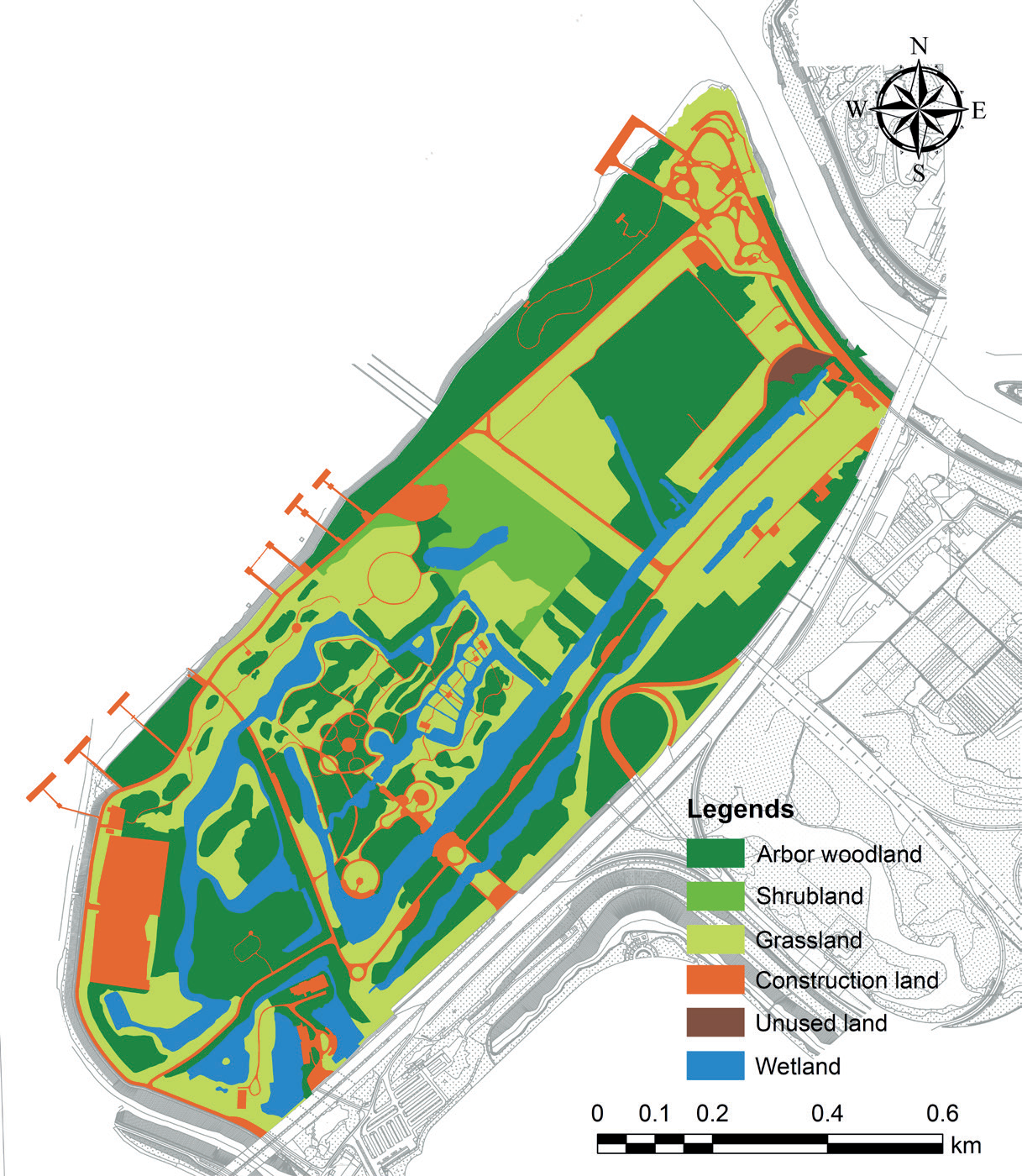
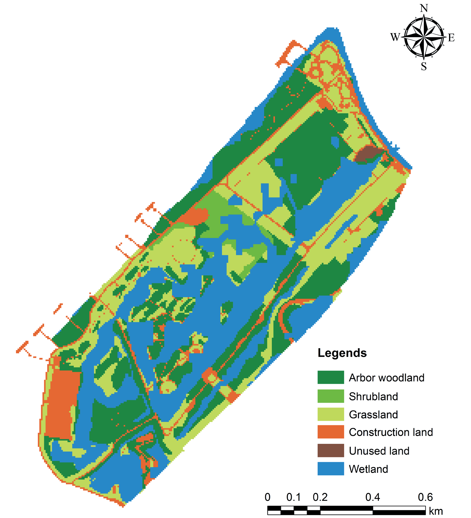
The data utilized in this study encompass remote sensing image data, digital elevation model (DEM) data, and social and economic data of Dashengguan Park. The remote sensing image data was sourced from Worldview-2 imagery, featuring four multispectral bands (2mresolution) and one panchromatic band (0.5m resolution) acquired in 2022. Employing ArcGIS 10.8 software, the remote sensing image was cropped. Referencing the Current Land Use Classification Standard of the People’s Republic of China in 2017 [32], and supplemented with field surveys to classify the landscape types within the study area into six categories: arbor woodland, shrubland, grassland, wetland, construction land, and unused land. Subsequently, the remote sensing image was visually interpreted manually to delineate the spatial distribution of current land use in Dashengguan Park (see Fig. 2). The Digital Elevation Model (DEM) data was acquired from the Copernicus DEM released by the European Space Agency (ESA) in 2022 and used to simulate various water surface ratios within the park. Furthermore, social and economic data were collected from the Nanjing Statistical Yearbook 2022 [33], the China Territorial Survey Results Sharing and Application Service Platform [34], and the Compilation of Cost and Benefit Data of National Agricultural Products 2022 [35].
Methods
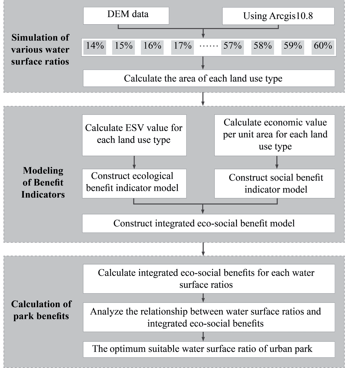
This study integrated ecological and social factors to propose a method for determining the suitable water surface ratio for urban parks (see Fig. 3). Based on the topography of Dashengguan Park, 47 different water surface ratios were simulated using ArcGIS 10.8 software. Ecological and social indicators for various land use types were calculated, and models for ecological, social, and integrated eco-social benefits were constructed. By assessing the benefits of different water surface ratios, the intrinsic correlation between water surface ratios and park benefits was analyzed, ultimately identifying the suitable water surface ratio that maximizes the park’s integrated benefits.
Simulation of Various Water Surface Ratios
The current water surface ratio was calculated to be approximately 13.74%, derived from the spatial distribution map of the park's current land use (see Fig. 2). Based on DEM data, the park's elevation ranges from 2 to 13.7 meters. Using ArcGIS 10.8 software and the principle of depression filling [36], 47 different water surface ratios were simulated, starting with a 14% water surface ratio and increasing by 1% increments up to 60%, based on the current water surface morphology and DEM data. These 47 water surface shapes were overlaid with other current land use types to obtain the land use distribution for each water surface ratio. The area of each land use type was calculated using the field calculator function in ArcGIS 10.8 software, and the changes in land use distribution with varying water surface ratios were analyzed.
Construction of Ecological Benefit Indicator Model
Referring to related studies [37-39], the ecological benefit indicator formula of the park was constructed. The specific calculation formula is as follows:
Where F1(x) represents the overall ecological benefits of the park, the variable xi represents the ith land type (x1-6 represents arbor woodland, shrubland, grassland, wetland, construction land, and unused land, respectively), ai represents the ecological benefit coefficient for the ith land type. The ecological benefits of land use types are typically quantified by their ecosystem service value (ESV) [18, 19, 40]. In this study, the ecological benefit coefficients were calculated using the ESV equivalent factor method [41]. Given that food production and landscape aesthetics possess socioeconomic attributes [42], these two ecosystem service values were omitted, and only the remaining ecosystem service values were employed to calculate the ecological benefit coefficients for each land use type.
Following the approach outlined by Lu et al. [43], the table of ESV equivalent factors for China established by Xie et al. [44] was adjusted using Nanjing's spatiotemporal regulating factors for net primary productivity (NPP), precipitation, and soil retention, resulting in the table of ESV equivalent per unit area specific to the study area (see Table 1).
The ESV equivalent factor is the potential capacity of the relative contribution size of ecosystem services produced by ecosystems, defined as the economic value of the annual natural grain yield from 1 hectare of farmland at the national average yield [45]. Following the methodology of Xie et al. [44], the ESV of 1 standard equivalent factor was calculated using the net profit of the three major grain crops (rice, wheat, and corn) in Nanjing in 2021. The calculation formula is as follows:
D represents the ESV of one standard equivalent factor (CNY/ha); Sr, Sw, and Sc represent the planting area proportions of rice, wheat, and corn in Nanjing in 2021, respectively; Fr, Fw, and Fc represent the average net profit per unit area (CNY/ha) of rice, wheat, and corn in China in 2021, respectively. According to the Nanjing Statistical Yearbook 2022 [33] and the Compilation of Cost and Benefit Data of National Agricultural Products 2022 [35], the value of D was calculated to be 1295.34 (CNY/ha).
Referring to related studies [41, 46, 47], the ESV of the construction land was assumed to be 0. Based on the D value and Table 1, the ESV per unit area in the study area was calculated (see Table 2).
The total ESV per unit area (ten thousand CNY/ha) was used as the ecological benefit coefficient for each land use type. Since urban park wetlands bear part of the recreational function and are relatively heavily artificialized, the ecological benefits they produce are not as great as those of natural water surfaces. Habitat quality is one of the important indicators for assessing ecological benefits [48]. Therefore, referring to the Technical Criterion for Ecosystem Status Evaluation formulated by the Ministry of Ecology and Environment of the People's Republic of China [49], the ecological benefit coefficient for wetlands was adjusted according to the habitat quality weight ratio of wetland to woodland. The final ecological benefit indicator formula is as follows:
Table 1.
ESV equivalent per unit area in the study area.
Table 2.
ESV per unit area in the study area (unit: CNY/ha).
Construction of Social Benefit Indicator Model
Similarly, the social benefit indicator formula of the park was constructed, the specific formula is as follows:
Where F2(x) represents the overall social benefits of the park, bi represents the social benefit coefficient for the ith land type. This study used the economic value per unit area to denote the social benefit coefficients. Output value data was extracted from the Nanjing Statistical Yearbook 2022 [33], while the area of each land use type in Nanjing was sourced from the China Territorial Survey Results Sharing and Application Service Platform [34]. Subsequently, the economic value per unit area (ten thousand CNY/ha) for each land use type was computed. Specifically, the economic value of woodland was represented by the forestry output value in Nanjing, and the economic value of construction land was denoted by the output value of secondary and tertiary industries. Considering the specific characteristics of the study area and referring to Peng et al. [42], the economic value of grassland was set at 10% of Nanjing’s livestock output, and the economic value of wetland was set at 10% of fishery output, since their values are not solely derived from these industries. Consistent with relevant studies [50, 51], the economic value of unused land was designated as 0. Finally, equation (4) can be rewritten as follows:
Construction of Integrated Eco-Social Benefit Model
To calculate the integrated benefits of the park with different water surface ratios, we considered the balance between ecological and social development, and constructed the integrated eco-social benefit model, with the calculation formula for integrated benefits as follows:
λ1 and λ2 represent the weight coefficients of ecological benefits and social benefits, respectively. To ensure the comparability of the two value systems [42], after repeated debugging and expert consultation, the coefficients in the formula were set as λ1 = 1/31.97 and λ2 = 1.
Results
Changes in Land Use with Various Water Surface Ratios
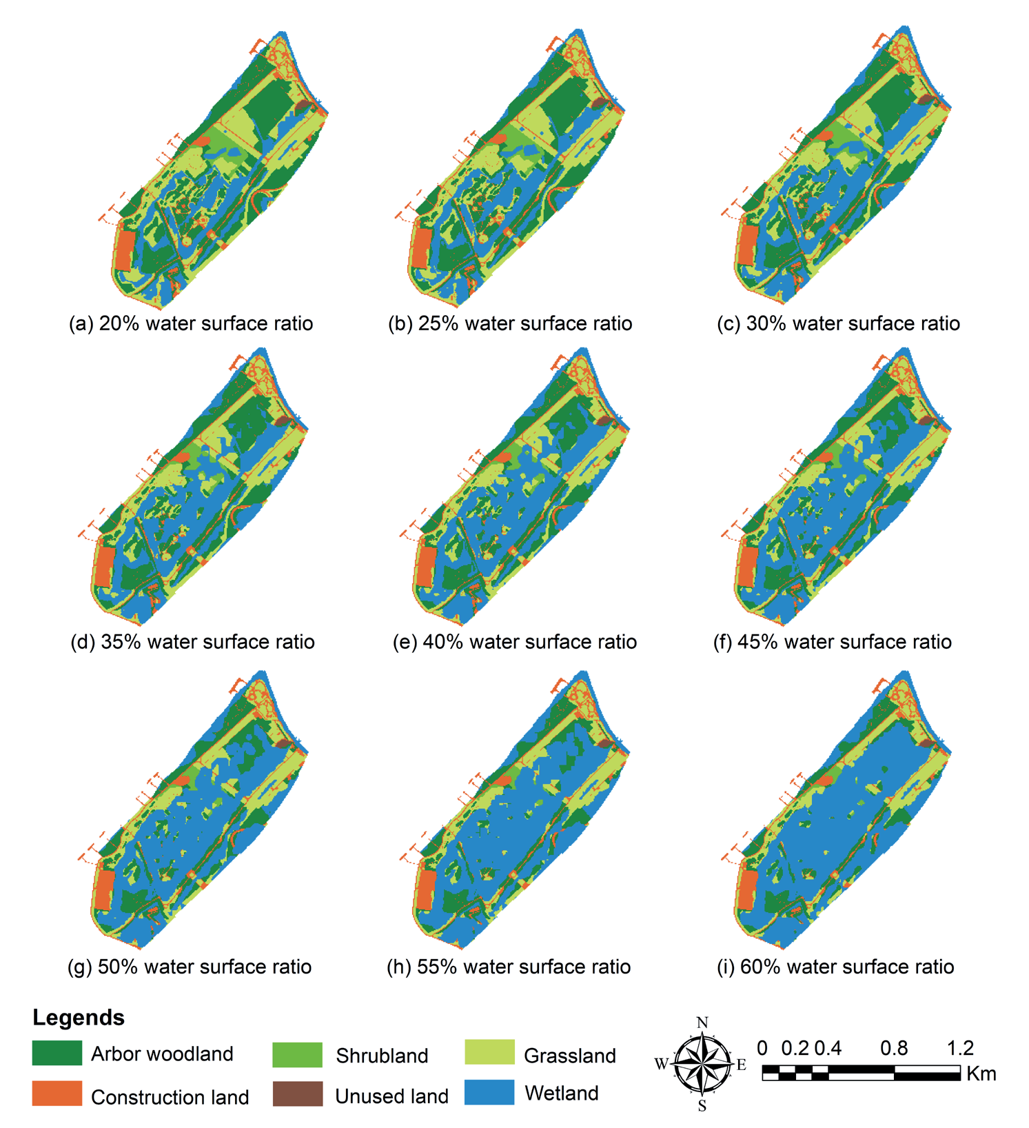
In the current land use types of Dashengguan Park, arbor woodland and grassland occupy the largest areas, followed by wetland and construction land, with shrubland and unused land occupying the smallest areas (see Fig. 2). Utilizing ArcGIS 10.8, we simulated 47 different water surface ratios ranging from 14% to 60%, Fig. 4 illustrates the spatial distribution of land use for 9 of these ratios. As shown, as the water surface ratio increases, the near-shore land use types gradually become inundated, leading to varying degrees of area reduction. The changes in the area of each land use type are presented in Fig. 5 and Table 3. Arbor woodland saw the most significant reduction, declining by 26.02 hectares, followed by grassland, which decreased by 21.02 hectares. Construction land and shrubland decrease by 3.68 hectares and 3.16 hectares, respectively, with the least reduction in unused land, which decreased by 0.06 hectares. This indicates that as the water surface ratio increases, larger, concentrated nearshore natural land use types are the first to be inundated, resulting in more substantial area reduction, while smaller, more distant land use types experience less reduction.
Changes of Ecological Benefits with Various Water Surface Ratios
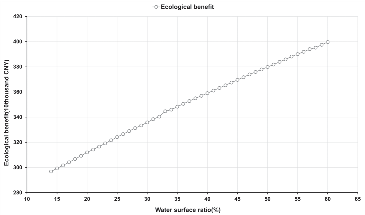
The ecological benefits of Dashengguan Park across 48 different water surface ratios, ranging from 13.7% to 60%, are shown in Fig. 6. The results indicate that the water surface ratio significantly impacts the park’s ecological benefits. As the water surface ratio increases, the ecological benefits gradually rise. At the current water surface ratio of 13.7%, the ecological benefits are the lowest, at 2,961,100 CNY. When the water surface ratio reaches 60%, the ecological benefits are the highest, at 3,997,200 CNY, an increase of 1,036,100 CNY compared to the current water surface ratio.
Fig. 5.
Changes of land use area with various water surface ratios, 13.7% for the current water surface ratio.
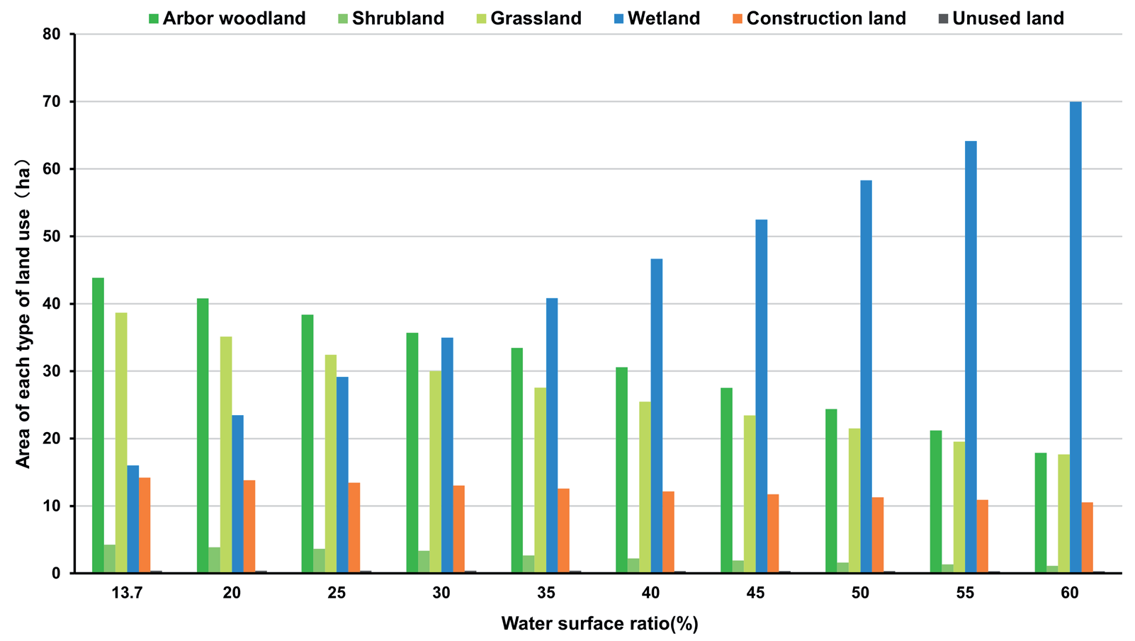
Table 3.
Land use area and changes in value for various water surface ratios.
Changes of Social Benefits with Various Water Surface Ratios
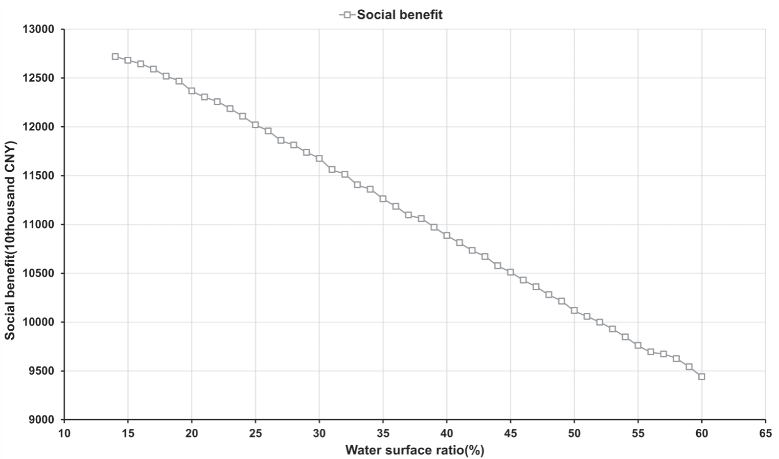
Fig. 7 illustrates the changes in social benefits of Dashengguan Park across 48 different water surface ratios, ranging from 13.7% to 60%. The results indicate a significant impact of the water surface ratio on the social benefits of the park, with social benefits substantially decreasing as the water surface ratio increases. At the current water surface ratio of 13.7%, the social benefits are the highest, at 127,228,400 CNY. Conversely, it reaches its lowest value when the water surface ratio reaches 60%, at 94,414,900 CNY, a decrease of 32,813,500 CNY compared with the current water surface ratio.
Changes of Integrated Eco-Social Benefits with Various Water Surface Ratios
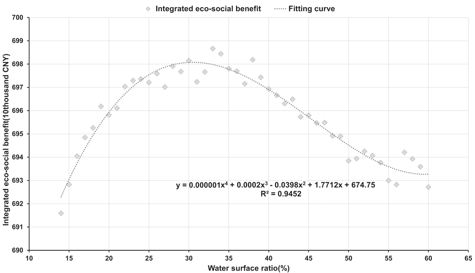
The changes in the integrated eco-social benefits of Dashengguan Park across 48 different water surface ratios are shown in Fig. 8. It is shown that the integrated benefits are the lowest at the current water surface ratio, at 6,909,400 CNY. According to the fitted curve, as the water surface ratio increases from 13.7% to 31%, the integrated benefits demonstrate an upward trend, which then tends to flatten out, eventually reaching a peak of 6,986,600 CNY at 33%. At this point, the wetland area spans 39 hectares (see Fig. 9). However, as the water surface ratio increases from 31% to 60%, the integrated benefits exhibit a downward trend.
Discussion
Impact of Water Surface Ratio on Benefits of Urban Parks
The current ecological and social benefits of Dashengguan Park are unbalanced, characterized by extremely low integrated eco-social benefits, which can be attributed to the park's low water surface ratio. This indicates that the initial planning and design did not fully consider the impact of the water surface ratio on the park’s benefits. The study results show that the water surface ratio significantly influences both the ecological and social benefits of the park, revealing a strong relevance between the water surface ratio and ecological environment as well as social development. This aligns with the research of Pal and Talukdar [52], who identified changes in wetland ratio as the primary driver of shifts in regional habitat quality and economic turnover capacity.
Fig. 8.
Changes of integrated eco-social benefits with 47 water surface ratios, with the first point indicating the integrated benefit of the status quo water surface ratio (13.7%).
Impact of Water Surface Ratio on the Ecological Benefits of Urban Parks
Water bodies provide strong ecological services [53, 54]. The results demonstrate that as the water surface ratio increases, the ecological benefits of the park also increase (see Fig. 6). This is due to the substantial increase in wetland area and the highest ecological benefits provided by wetlands (see Eq. 3). These findings are consistent with other studies, which have also found that the size of the water area is proportional to its ecological benefits. For example, Tian et al. [55] found that a decrease in water surface ratio leads to a decline in the habitat quality of the surrounding environment. Similarly, studies by Xu et al. [56] and Theeuwes et al. [57] indicated that an increase in the water surface ratio enhances climate regulation functions.
Impact of Water Surface Ratios on the Social Benefits of Urban Parks
The results of this study reveal that as water surface ratio increases, the social benefits of the park decrease (see Fig. 7). This contradicts the findings of Pal and Talukdar [52], who observed that a reduction in the wetland ratio decreases regional economic turnover capacity. This discrepancy can be attributed to the diverse land use types present within urban parks, where wetlands represent just one component. The expansion of water bodies reduces the area of other land use types, and the social benefit coefficient of wetlands is the lowest among all land use types (see Eq. 5). Thus, even though the wetland area increases, the overall social benefits of the park decrease.
The Suitable Water Surface Ratio of Urban Parks with Optimal Integrated Eco-Social Benefits
As a comprehensive urban park, Dashengguan Park needs to take into account both ecological and social benefits. Therefore, based on our findings, we have determined that the optimal water surface ratio for the park is 33%, where integrated eco-social benefits are maximized (see Fig. 9). Our study shows that the water surface ratio significantly impacts the park’s integrated eco-social benefits, with benefits initially increasing and then decreasing as the water surface ratio rises (see Fig. 8). This occurs because, in urban parks, an increased water surface ratio enhances ecological benefits but reduces social benefits, creating opposite trends. This contrasts with the findings of Li et al. [58], who found that the comprehensive benefits of lakes increase indefinitely with larger water areas, as their study focused solely on lakes, where both ecological and social benefits rise with expanding water surfaces.
Therefore, the water surface planning of urban parks should be combined with the goals of ecological protection and social development, to leverage the significant value of water bodies in both social and ecological aspects [58]. While some studies have considered either ecological or social needs, such as Wang [24], who integrated the functional needs of maintaining ecological balance, drainage, and flood prevention to calculate the reasonable water surface ratio, and Bu et al. [27], who incorporated social cost-benefit considerations to determine the suitable urban water surface ratio with the lowest socio-economic cost, relevant research suggests that future investigations into suitable water surface ratios should integrate both social and ecological factors [59]. Therefore, in contrast to previous studies, our research comprehensively considers both ecological and social factors, providing a more holistic calculation method.
Implications for Urban Park Planning and Construction
Providing a Scientific Basis for the Optimization of Dashengguan Park
The results of this study offer practical guidance for optimizing Dashengguan Park. When the water surface ratio is 33%, the water system can connect the entire site, improving the flow and connectivity of the water body. This enhances the ecological value of the water body while ensuring sufficient space for activities and passage (see Fig. 9). The terrain-based method for simulating the water surface ratio reduces economic costs, and the adjustable water surface of Dashengguan Park makes the study results more practical. Our landscape design team replanned Dashengguan Park based on the 33% water surface ratio and corresponding water body morphology. The final plan received approval and support from the local government.
Offering Guidance for the Planning and Construction of Urban Parks with Water Bodies
Nowadays, an increasing number of urban parks are built around water systems, making water bodies key landscape elements in many urban parks. However, different types of parks play varying roles in providing ecological and social benefits [60], and their water surface ratio requirements differ accordingly. Therefore, it is essential to plan the water surface ratio reasonably, based on the specific characteristics of each park type. Additionally, practical considerations such as earthwork balance and economic costs must be weighed to assess the feasibility of water surface ratio setting. For example, comprehensive parks that fulfill social needs for leisure, recreation, and education [61] while providing a good ecological environment [62]. These parks require the consideration of both ecological and social values to maximize integrated eco-social benefits. Using the method from this study, integrated benefit models can be constructed according to local economic development and ecological conditions to determine the optimal water surface ratio of the park. On the other hand, community parks, amusement parks, children's parks, sports and fitness parks, and heritage parks primarily cater to specific recreational activities and are essential for providing social benefits [60]. In these specific cases, the water surface ratio should not be excessively high. Natural parks, represented by wetland parks, offer significant environmental benefits [60]. Setting a higher water surface ratio based on the site's aquatic ecological environment can yield higher ecological benefits. Moreover, the method for planning the water surface ratio of urban parks varies depending on their geographic location. Parks situated closer to the city center need to prioritize generating higher social benefits, so more social factors should be considered when determining the suitable water surface ratio. Conversely, parks located on the outskirts or near the suburbs, which primarily feature natural landscapes, should focus on maximizing ecological benefits when determining their water surface ratios.
Providing Insights for the Planning and Construction of Urban Parks without Water Bodies
The essence of this study’s methodology lies in the significant impact of land use patterns on park benefits. Due to geographical conditions or resource limitations, many urban parks do not include water bodies in their planning but still need to enhance their comprehensive benefits. The approach proposed in this study can provide a reference for the planning of such parks. For example, besides wetlands, arbor woodlands and grasslands also generate high ecological benefits (see Eq. 3), and their social benefits are slightly higher than those of wetlands. Therefore, the proportions of these two land types can also significantly influence park benefits. When planning such parks, different ratios of grassland or forest can be set, and integrated benefit models can be constructed to measure park benefits. This approach helps to determine the optimal land use ratio, effectively guiding the planning and construction of the park.
Limitations of the Study
Firstly, excessive water area in urban parks can result in limited space for visitors and high construction costs. Additionally, excessive artificial lake excavation can cause challenging earthwork issues, violating the ecological principles of park construction [63]. Therefore, this study didn’t discuss or analyze the benefits of parks with a water surface ratio exceeding 60%. Secondly, while this study focused on a specific urban park, geographical differences mean that suitable water surface ratios vary by location [24]. Consequently, the suitable water surface ratio derived from this study may not be universally applicable to all urban parks but can serve as a reference for parks in similar regions with comparable scales and topographical conditions. This study also provides a scientific method for the planning and construction of other urban parks.
Conclusions
Reasonably planning the water surface ratio of urban parks is crucial for their sustainable development. This study proposed a novel method for determining the suitable water surface ratio of urban parks. Taking Dashengguan Park in Nanjing as an example, we used the ArcGIS 10.8 platform to simulate various water surface ratios ranging from 14% to 60%, and constructed index models for ecological, social, and integrated eco-social benefits. We calculated the park benefits of different water surface ratios and analyzed the correlation between water surface ratios and park benefits to determine the most suitable water surface ratio that maximizes the integrated benefits. The main findings of this study are as follows: The water surface ratio significantly impacts urban park benefits. As the water surface ratio increases, the ecological benefits increase while the social benefits decrease, and the integrated eco-social benefit initially rises, peaks, and then gradually declines. However, notably, at a water surface ratio of 33%, Dashengguan Park achieves relative maximization of its integrated eco-social benefit, aligning with the park’s current development goals. Thus, 33% emerges as the most suitable water surface ratio for Dashengguan Park, providing a scientific basis for park construction optimization. The method proposed in this study offers a new perspective for urban park planning and design, helping planners and managers make more scientific and reasonable land use configurations. Future research should focus on other urban parks to develop a suitable water surface ratio system applicable to different types and regions, and attempt to form suitable water surface ratio intervals. This will provide a basis for park design standards and related policies, enhancing the generalizability of the research results. For parks without water bodies, future research should be guided by the demand to enhance benefits and develop scientific methods for calculating land use ratios based on the approach of this study to inform the planning and construction of various types of parks.

