

Introduction
With the continuous enrichment of material conditions, residents also have a higher demand for urban environments. At a time when the urbanization process is carried out at a high speed, people’s life rhythm is also gradually accelerated, and the psychological pressure accumulated over time seriously affects the physical and mental health and daily life of the residents [1]. The urban landscape is the appearance and atmosphere formed by squares, streets, buildings, landscaping, and so on, including natural landscape elements and artificial landscape elements, which can make the city with natural landscape art so that people have a sense of comfort and enjoyment in urban life [2]. Natural landscape is a general term for the natural aspects of natural and cultural landscapes, and the existence of landscape space should provide the basic conditions for users to meet different needs, including material and spiritual [3]. The influence of the natural environment on people’s physical and mental health should not be underestimated, and many past studies have found that the natural landscape has a better regulating effect on people’s emotions, so the urban landscape design occupies a very key position in urban construction [4, 5]. However, how to create a spatial environment that meets the requirements of psychological healing efficacy in uniform urban landscapes is still a major challenge for relevant designers. In this context, research proposes applying the theory of restorative environment to urban landscape design to evaluate the degree of attention restoration of individuals by urban landscapes. Furthermore, based on this, a Convolutional Neural Network (CNN)-based urban landscape feature recognition model is further constructed to provide a more accurate composition of urban landscape elements, providing more realistic and reliable data support for the optimization design of urban landscapes. This helps designers to effectively and targetedly integrate resilience theory into the design process. There are two main innovations in this study. The first is to integrate the attention restoration theory in the healing environment theory into the design and planning of urban landscapes. The second point is to introduce the polarized self-attention mechanism and construct the urban landscape element identification model.
The main structure has four parts: The first is to analyze the current status of the related research; the second is to evaluate the urban landscape using the theory of restorative environment and to build a CNN-based urban landscape element recognition model; the third part is to analyze the evaluation results and application effect; and the last part is to summarize the whole study.
Related Works
A restorative environment is defined as a special environment that promotes the recovery and renewal of people’s depleted physical and mental resources and abilities, emphasizing the active impact of the environment on the health of the individual. Gharipour et al. pointed out that there is little research on the effectiveness of architectural design in creating a healing environment. Therefore, in order to determine fast, effective, and low-cost architectural design solutions, qualitative and quantitative methods are used to evaluate the healing environment, which can help improve the health of patients, visitors, and staff [6]. Craig et al. provided a narrative review of the literature on environmental psychology to improve productivity and psychological well-being during shelter-in-place and discussed how these findings could be applied to workers during the Neo-Confucian pneumonia pandemic. The application of restorative environments can help to mitigate the negative psychological effects of sheltering at home to combat neocoronavirus pneumonia [7]. Backman et al. To test the restorative potential of healthy tourism environments from both an environmental psychology and consumer perspective, they developed and tested a theoretical framework based on Kaplan and Kaplan’s (1989) Attention Restoration Theory framework using the theory of restorative environments model. The results showed that restorative environments contribute to positive mood and life satisfaction [8]. Bornioli et al. addressed the mental health challenges faced by cities by proposing a theoretical model based on restorative environment theory that elucidates the physical and symbolic characteristics of urban environments and can provide important insights for healthy city strategies [9]. Pichlerová et al. indicated that forested environments contribute to subjective well-being and stress relief and have health benefits, and conducted a survey using a digital questionnaire, and the results of the Wilcoxon test and ordered regression analysis indicated that the new crown epidemic reinforced the perception of the forest as a high-quality recuperative environment [10]. Wang et al. responded to the issue that large-scale spatial development may damage the psychological perception of historic sites by using the Perceptual Recovery scale to study the psychological resilience of courtyards. The results verified the psychological restorative properties of historical pagoda courtyards and provided a scientific basis for urban planning and management strategies [11].
Landscape design focuses on the design and planning of land and human outdoor spaces, harmonizing the relationship between humans and nature through systematic planning and design to create outdoor spaces with unique aesthetics and functionality. Shareef, to provide a holistic picture of the atmospheric impacts of greenery, investigated the impacts of greenery on the urban heat island effect at various levels and three types of urban heat island effect as well as various types of greenery in order to understand their effects on outdoor microclimate parameters and the urban heat island effect in hot climates [12]. Erdem Kaya reviewed ten cases related to landscape design to address the challenges posed by pollution in public spaces. A research matrix and type classification were provided to demonstrate how restoration methods can be translated as a landscape design strategy, which can help provide different solutions for well-functioning and open space design schemes [13]. Żychowska et al. analyzed typical examples of traditional landscape design in Japan and China in order to explore the function of religious beliefs and philosophical teachings in the development of traditional landscape design principles and techniques. The results showed that both Japanese and Chinese landscape design followed principles similar to those developed in other types of art in their own countries [14]. Lallawmzuali et al. stated that computer-aided design software has revolutionized landscape design and is gradually replacing manual drawing and hand painting. Through computer-aided design software, designers can work more efficiently and produce higher-quality landscape designs, and it can also stimulate the infinite possibilities and creativity of landscape designers [15]. Wang stated that the traditional landscape architectural design methods and layouts can no longer satisfy modern aesthetic needs and that the integration of computer technology and landscape planning has become increasingly close. The main application direction of computer-aided design in the garden provided an ecological auxiliary system construction program [16]. Lv analyzed the current national policy of China’s development of rural construction, defined specific concepts of rural revitalization strategy and rural landscape design, and also conducted a strategic analysis of the application of ecological landscape in the rural landscape, which helps to provide ideas for rural landscape design [17].
In summary, although many previous experts and scholars have discovered the restorative nature of natural environments and have conducted a lot of research on landscape design, however, the research on the healing environment is still in the primary stage, and landscape design is not rich enough in the concept of health. Therefore, this study is based on the theory of healing environment for urban landscape design, which has important practical application value and prospects.
Materials and Methods
The influence of the natural environment on people’s physical and mental health should not be underestimated. In order to improve the mental fatigue and bad mood regulation effects of urban environments and create a good urban atmosphere, the study will utilize the theory of recuperative environments to evaluate the urban landscape and build a CNN-based recognition model of urban landscape elements.
Urban Landscape Evaluation Based on the Theory of Resilience
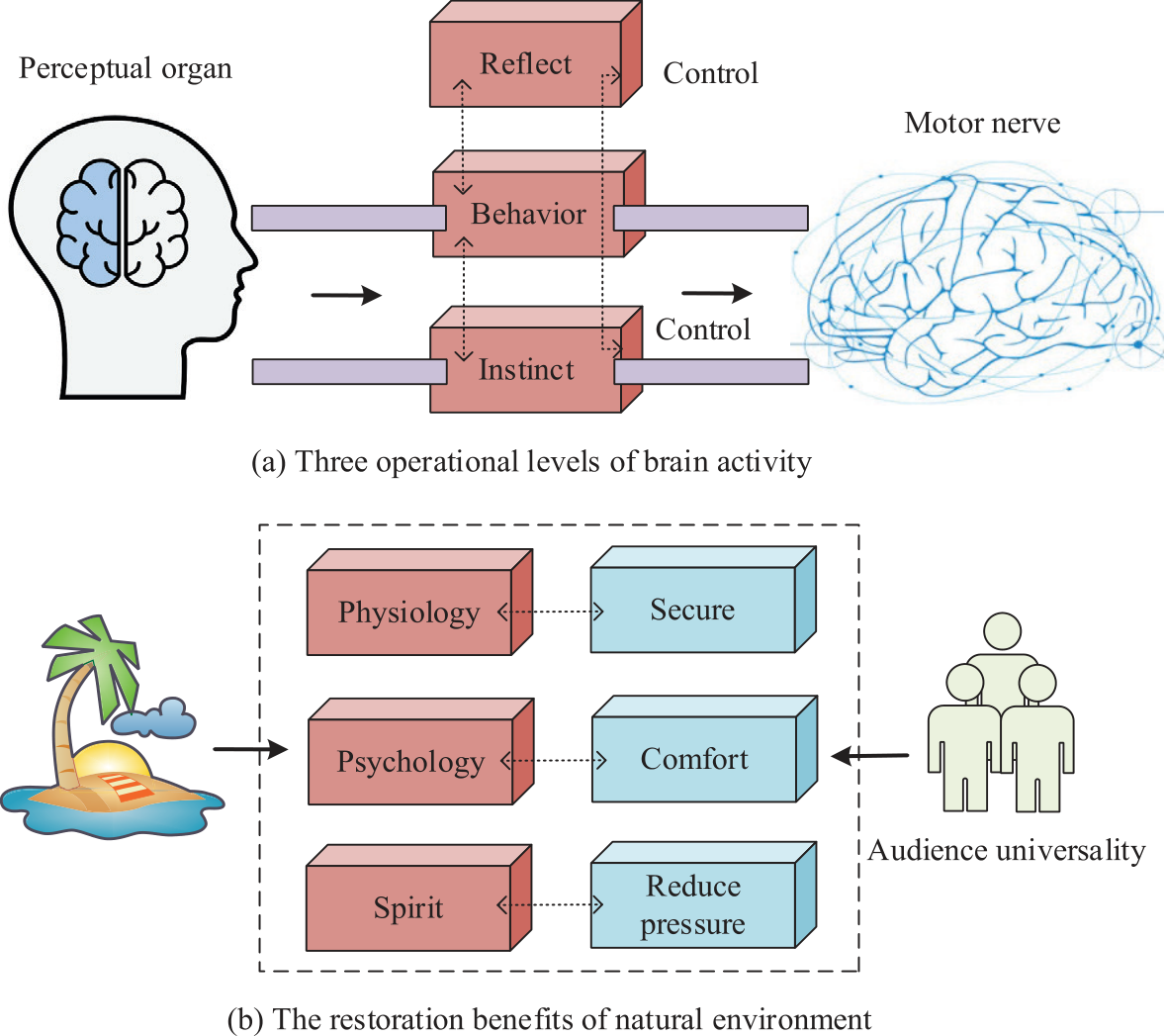
For a long time, the natural landscape has become an important way for people to relieve their illnesses and release their pressure. Creating urban green space through the use of the natural environment is an effective and economical way of choosing to improve the urban ecological environment as well as the social image. Urban landscape refers to the landscape function in the human settlement environment inherent and created by the beauty of the natural landscape, which can make the city with natural landscape art so that people have a sense of comfort and enjoyment in urban life [18]. People and the environment are interdependent, and co-development, the gradual increase in human material conditions and spiritual conditions of the demand makes us for the environment more and more strong, the environment has a certain role in regulating psychological fatigue and bad mood, contact with the natural environment is more beneficial to the psychological recovery. Emotions have an important impact on the operation of human daily life; human brain activity is divided into three levels of the overall function of the human body that play different roles, so the urban landscape design is crucial, indirectly affecting the daily life of the residents. The three operational levels of brain activity and the recovery benefits of the natural environment are shown in Fig. 1.
In order to make the urban landscape play the role of regulating and relaxing the residents’ emotions, the study proposes to apply the theory of restorative environment to urban landscape design. The healing environment refers to the environment that has the effect of restoring the residents’ physical strength and health level, including the two major theories of stress reduction theory, psychological evolution theory, and attention restoration theory. The theory of stress reduction refers to the fact that users who suffer from psychological and behavioral stress due to various negative stimuli in daily life can be cured in the restorative environment, and the condition of cure is that the users have full contact with the natural elements in the restorative environment. The theory of attention restoration refers to the fact that people’s attention is easily attracted to natural environments, and psychological fatigue can be reduced without consuming their own psychological functions [19]. In order to evaluate the restorative properties of a certain natural landscape environment in an all-encompassing and multi-dimensional way, four typical characteristics, namely, remoteness, extensibility, charm, and compatibility, are clarified under the framework of the attention restoration theory, which defines the ways in which restorative environments are able to bring about stress relief to the psyche of the users. Currently, the most commonly used evaluation method for attention restoration is to use the Perceived Restorativeness Scale (PRS) [20]. The specific evaluation indexes of PRS are shown in Table 1.
However, a single restorative evaluation lacks a comprehensive examination of environmental elements. Therefore, the study evaluates the attentional restoration effect of the environment through PRS and draws conclusions from data analysis of the performance of different urban scenes in the four dimensions of attentional restoration. At the same time, the Semantic Differences (SD) method was used to evaluate the environmental elements of the urban landscape and analyze the environmental elements affecting the effect of attention restoration. The SD method refers to the screening of the language vocabulary of the residents around the parks, summarizing the summary results for the division of the indicators, and selecting appropriate adjectives to describe the indicators. Finally, professional students were asked to score all the park scenes according to the indicators. Professional students are then asked to score all the park scenes according to the indexes so as to dataize people’s psychological feelings. The relevant data are then statistically analyzed through the data analysis method, and the obtained data can be used as support for urban healing landscape renovation design, which provides a certain reference for the renovation design.
This quantitative evaluation method can assess the degree of attention restoration of individuals by urban landscapes and, to a certain extent, focus on the adaptability and sustainability of urban landscapes, thereby providing some reference for urban landscape design with psychological healing effects. However, this evaluation method may also lead to subjective bias, resulting in limitations in the evaluation results and an inability to provide important details about landscape composition. Therefore, it is crucial to accurately identify the specific landscape elements that affect the resilience of urban landscapes after evaluating their resilience in order to make targeted improvements in urban landscape design and enhance the city’s resilience.
Table 1.
Perceived Restorativeness scale.
CNN-Based Urban Landscape Element Recognition Model Construction
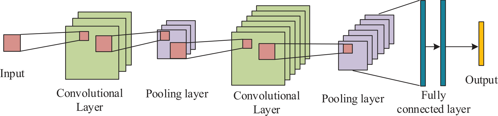
On the basis of conducting a restorative evaluation of urban landscapes, in order to provide a large amount of landscape data for urban landscape design, help designers better understand the structure and composition of existing landscapes, and provide a scientific basis for urban landscape design, research will further identify the elements of urban landscapes. In urban landscapes, the environment of historical core areas is usually more complex and difficult to identify. Therefore, research mainly takes historical core areas as an example to explore effective identification methods for urban landscape elements. Deep learning has been widely used in image recognition but performs poorly in narrow streets and complex environments. To this end, a CNN-based urban landscape element recognition model is proposed to accurately recognize landscape elements in the historical core of the city. CNN is a type of feed-forward neural network that contains convolutional operations and has a deep structure, which is widely used in the fields of image recognition, natural language processing, speech recognition, etc. [21]. CNN generally includes five types of network hierarchical structures: input layer, convolutional layer, activation layer, pooling layer, and fully connected layer. Fig. 2 displays the basic structure.
Semantic segmentation is an image segmentation technique in the field of computer vision, and the core objective is to assign each pixel in an image to a predefined category, thus realizing a refined understanding of the image. Existing mainstream semantic segmentation algorithms are composed of an encoder and a decoder structure, where the encoder can map the input data into a high-dimensional feature matrix, which facilitates subsequent processing and analysis, and the decoder can distinguish the semantic differences between different landscape elements and then accurately extract various landscape elements. In order to adapt to the recognition of complex urban landscape elements, the study introduces a polarized attention mechanism to strengthen the model’s ability to discriminate between different landscape elements. ResNet-r50, an image classification network with fully connected layers removed, is selected as the encoder. resNet is a deep CNN that uses residual blocks to construct a deep network and to overcome the problems of gradient vanishing and gradient explosion caused by the increase in the depth of the network. resNet introduces a leapfrog link on each residual block and adds the output value in each residual block to the original input value, and the obtained output is as shown in Equation (1). The output obtained is displayed in Equation (1).
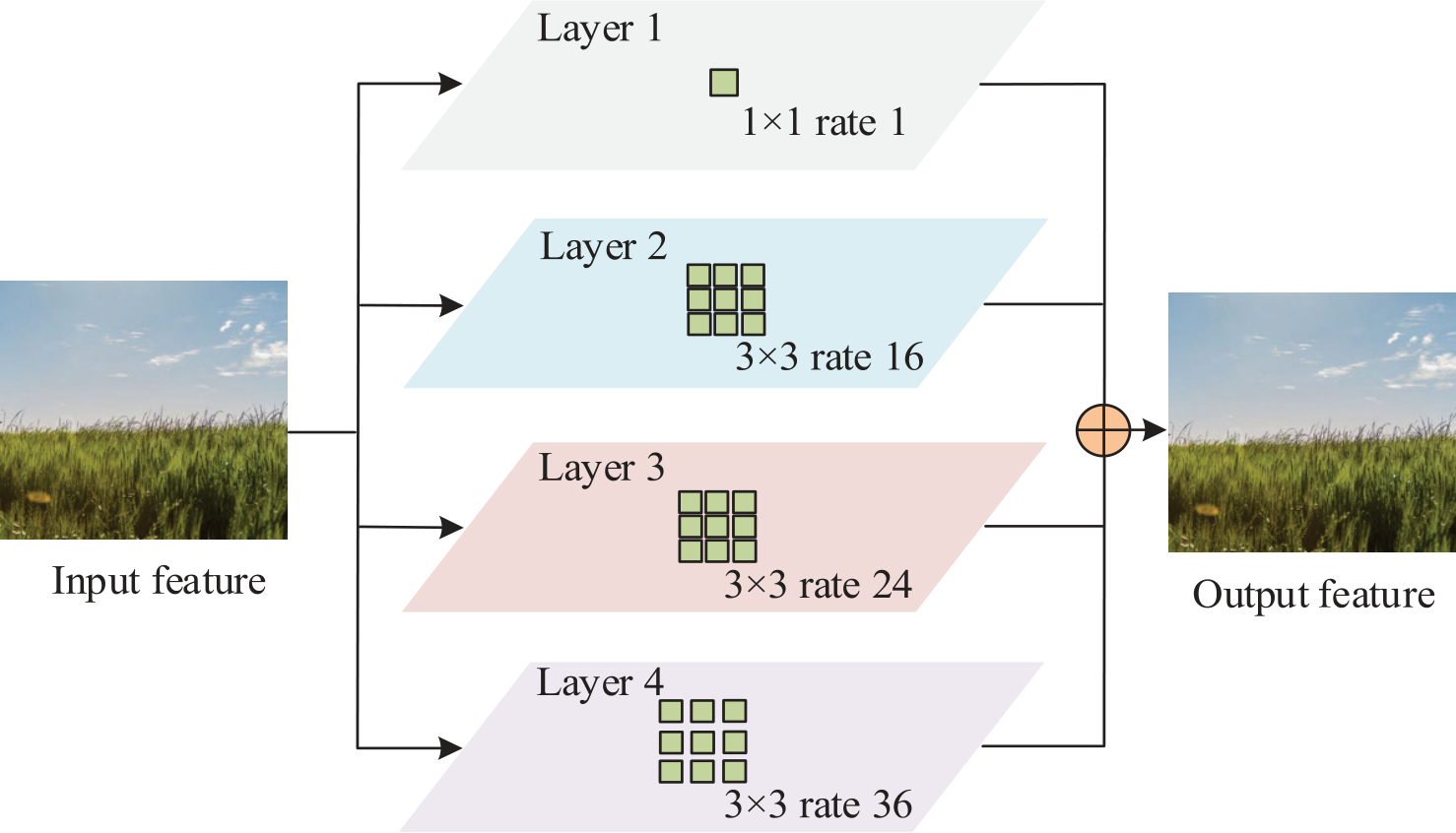
In Equation (1), F(x) denotes the output value of the residual block, x denotes the original input value, σ denotes the linear rectification function and W denotes the weight parameter of the convolutional layer. In order to solve the effect of the scale difference of landscape elements, the study introduces the inverse convolution solver dock combining Atrous Spatial Pyramid Pooling (ASPP) with null convolution as a semantic segmentation decoder, as shown in Fig. 3.
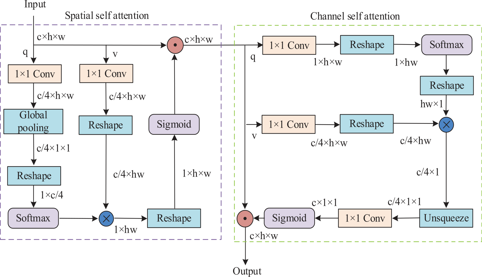
In order to further improve the extraction accuracy of urban landscape elements, the study introduces a polarized self-attention module in the encoder and decoder. The polarized self-attention module, as a more refined dual-attention mechanism, is able to maintain internal high resolution in spatial and channel dimensions, thus further reducing the information loss caused by the reduced dimensionality. The Softmax function is also used to enhance the range of attention in the branch where the dimensions are compressed, and finally, the Sigmoid function is used for dynamic mapping. The polarized self-attention module is obtained by fusing the spatial and channel self-attention branches in series. In this case, the process of the spatial self-attention module to get the feature map possessing spatial self-attention is shown in Equation (2).
In Equation (2), φ2, φ2, and φ1 denotes the weights of different layers, Psp(X) denotes the spatially polarized self-attention map, fSG denotes the activation function, σ denotes the Softmax function, fGP denotes the spatial pooling layer, W denotes the 1×1 convolution, and X denotes the input feature map. The channel self-attention module compresses the spatial information while fully retaining the channel information, which can efficiently extract the features of different categories of elements, and the study retains half of the total number of channels to compute the channel self-attention in order to improve the efficiency, as shown in Equation (3).
In Equation (3), Pch(X) denotes the channel polarization self-attention map. The study inputs the original feature maps to the spatial self-attention and channel self-attention modules, respectively, and sums the obtained feature maps to enhance the category characteristics and spatial distribution information of the landscape elements, as displayed in Equation (4).
In Equation (4), F(X) denotes the final attention map and
To improve the training efficiency, migration learning is introduced to train the network to learn landscape element features based on the street view information embedded in the existing dataset. The migration learning process of the encoder is shown in Equation (5).
In Equation (5), Pfe denotes the encoder parameters trained using generic visual information, Dimg denotes the visual image information, Tf denotes the image categorization task, Dhcsv denotes the landscape element features, and P'fe denotes the encoder parameters with landscape element information and generic visual information. The migration learning process of the decoder is shown in Equation (6).
In Equation (6), P and P' denote the decoder parameters before and after migration, respectively, and Pfe denotes the street feature recognition task. To assess the performance, the study uses Average Accuracy (AA); Overall Accuracy (OA); Intersection over Union (IoU), and Mean Intersection over Union (mIoU) as evaluation metrics. mIoU are used as evaluation metrics. AA is the average value of model recognition accuracy, as displayed in Equation (7).
In Equation (7), n denotes the total number of categories, X denotes the number of correct identifications, and Ni denotes the number of pixels whose true category is the i category. The calculation of OA is shown in Equation (8).
In Equation (8), M denotes the full number of pixels. The IoU is displayed in Equation (9).
In Equation (9), Xij denotes the number of pixels of class i that are recognized as class j and Xji denotes the number of pixels of class j that are recognized as class i. The calculation of mIoU is shown in Equation (10).
Results and Discussion
The study utilizes the theory of recuperative environment to evaluate the urban landscape and builds a CNN-based urban landscape element recognition model. However, its practical application effect has to be further verified. The study mainly analyzes from two aspects. First, it analyzes the evaluation results of urban landscapes based on the theory of compound healing, and then it analyzes the effect of a CNN-based urban landscape element recognition model.
Evaluation Results of Urban Landscapes Based on the Theory of Resilience
Five different spaces were selected as samples based on type, geographic location, and other factors, namely, plaza space, waterfront space, road space, rest space, and play space. In order to facilitate the statistical processing of the data, the evaluation scale was chosen to be 5 levels, with the highest value of 2 points and the lowest value of -2 points. For the five selected spaces, three dimensions and 15 evaluation indexes are formulated according to their landscape characteristics, and the evaluation indexes of the SD method are shown in Table 2.
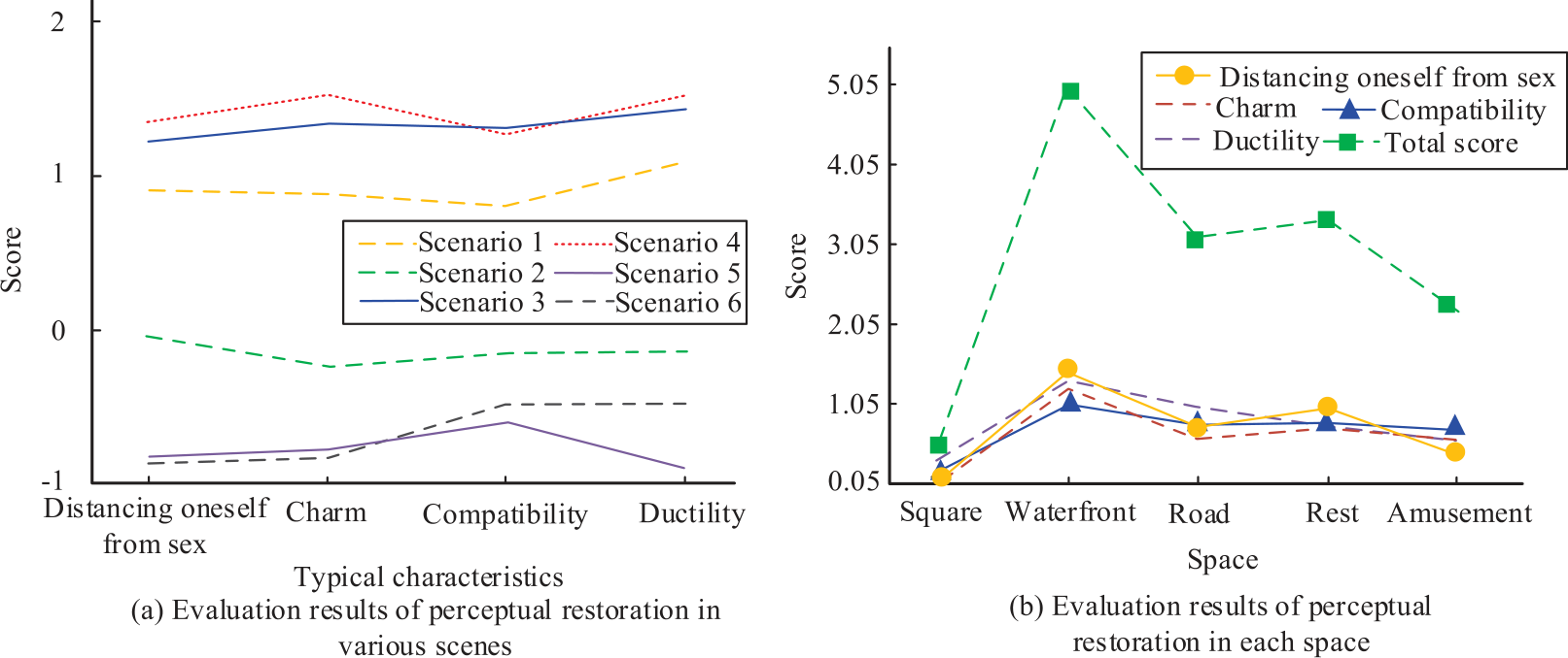
Six scenes were randomly selected from five spaces for evaluation, and 40 landscape design students were selected as research subjects for the study. A total of 50 questionnaires were issued, and 50 valid questionnaires were recovered, with a validity rate of 100%. The data obtained from the questionnaire were comprehensively statistically analyzed using Excel. The PRS evaluation results of the 6 scenes and 5 spaces are displayed in Fig. 5. From Fig. 5a), Scene 4 has the highest rating overall and Scene 5 has the lowest rating overall. From Fig. 5b), the waterfront space has the highest PRS rating, and the plaza space has the lowest PRS rating. The results indicate that the plaza space has the worst recovery of attention and needs to be optimally designed.
The SD evaluation results for the five spaces are displayed in Fig. 6. In Fig. 6, the plaza space landscape, which has the lowest restoration effect of attention, has the highest score on the openness evaluation indicator at 2.51. The waterfront space has the best performance overall, with no indicators with the lowest evaluation scores. Open space had the highest evaluation score on the public infrastructure indicator and the lowest evaluation score on the hydrophilicity indicator.
Effectiveness Analysis of the Urban Landscape Element Identification Model
To verify the CNN-based urban landscape element recognition model, the study uses the Cityscapes dataset for experiments and compares the improved CNN algorithm combined with the ASPP proposed (CNN-ASPP) in this study with three models, namely, the Fully Convolutional Network (FCN), the Asymmetric Non-local Neural Network (ANNN), and the Pointwise Spatial Attention Network (PSANet). The comparison of the metrics results of the four models is shown in Fig. 7. From Fig. 7a), it can be seen that compared to the other three models, the CNN-ASPP model has the highest AA metrics of 72.78%. From Fig. 7b), it can be seen that the CNN-ASPP model also has better performance in terms of OA metrics, with an OA value of 90.49%. From Fig. 7c), the CNN-ASPP model has the highest mIoU metrics with 63.8%. The proposed model has better performance in AA, OA, and OA indicators and has a better extraction effect of landscape elements.
Table 2.
SD method evaluation indicators.
The picture extraction results of FCN, PSANet, and CNN-ASPP are shown in Fig. 8. Comparing Fig. 8a), Fig. 8b), Fig. 8c), and Fig. 8(d), the FCN model has the worst performance, and the extracted pictures are more blurred. The PSANet model extracts clearer outlines, but the details are not clear enough. The CNN-based cityscape element recognition model extracts the most complete picture elements, demonstrating good picture element extraction.
To further qualitatively analyze the element recognition performance of the models, the study recognizes six different landscape elements. The IoU values extracted by the four models for different landscape elements are displayed in Fig. 9. From Fig. 9a), the FCN model has better results in recognizing the sky with an IoU value of 88.11%. From Fig. 9b), the ANNN model has the best results in recognizing buildings with an IoU value of 86.81%. It can be seen in Fig. 9c) that the PSANet model has the best recognition for buildings with an IoU value of 86.81%. In Fig. 9d), the model in this study has the best recognition for buildings with an IoU value of 90%. The IoU values for recognizing vegetation, roads, pedestrians, motor vehicles, and buildings are higher than the other three models, and the IoU value for recognizing the sky is 86.55%, which is 1.56% lower than the FCN model. The proposed model has the best recognition effect in general and has better performance for recognizing different landscape elements.
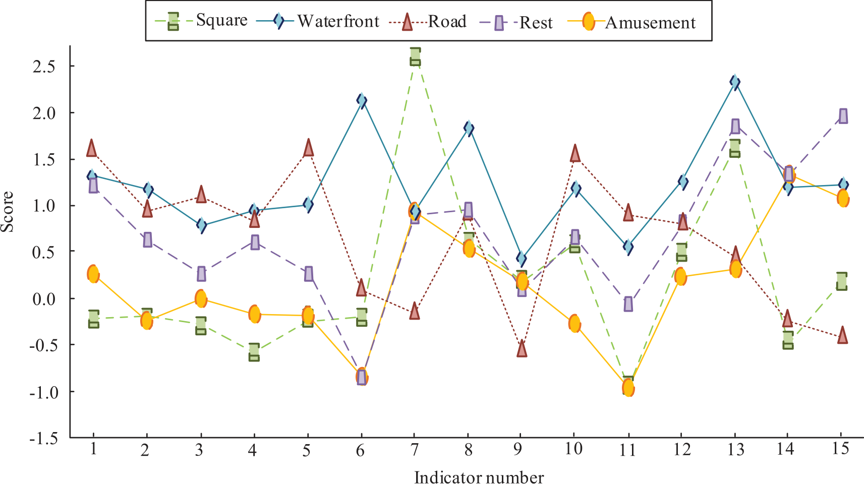
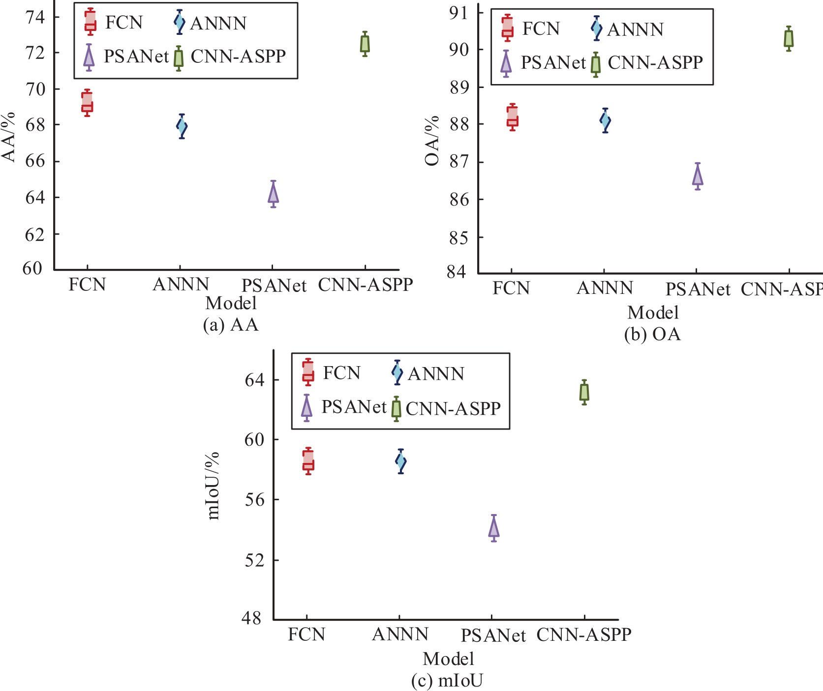
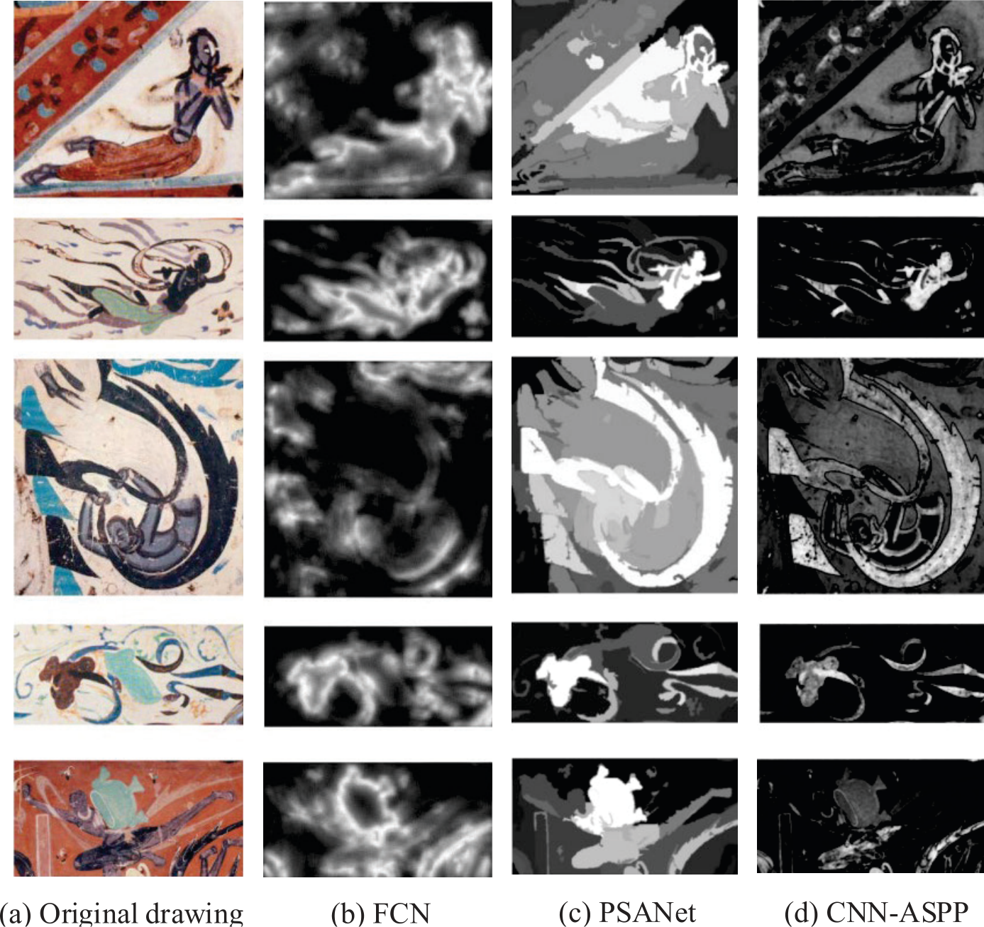
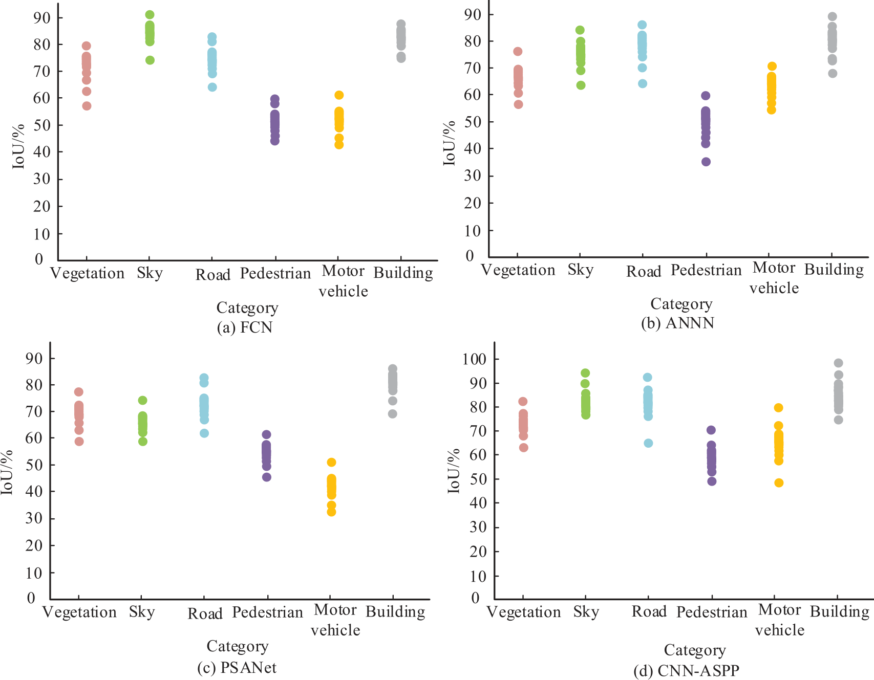
Table 3.
Comparison results of operational efficiency of four models.
| Model | Memory usage/Mb | Parameter quantity/10000 | GFLOPs | Predicting speed/FPS |
|---|---|---|---|---|
| FCN | 8765 | 4094 | 1583.95 | 1.1 |
| ANNN | 8754 | 3768 | 1481.31 | 1.2 |
| PSANet | 10368 | 5058 | 1599.36 | 1.1 |
| CNN-ASPP | 9178 | 4341 | 1619.98 | 1.2 |
In order to verify the running efficiency of the CNN-based urban landscape element recognition model, the study uses the significant memory occupation, the number of parameters, the GFLOPs, and the prediction speed as evaluation indexes for testing. The comparison results of the operational efficiency of the four models are displayed in Table 3. From Table 3, the CNN-ASPP model has a memory occupation of 9178 Mb, the number of parameters is 43.41 million, and the computational complexity is 1619.98 GFLOPs, which is slightly higher than that of the FCN and ANNN models, but it achieves higher efficiency, and the prediction speed is 1.2 FPS. The memory occupation and the number of parameters are substantially lower than those of the PSANet. The efficiency of the proposed model is competitive compared to large networks.
Conclusions
With the development of the economy and urbanization, the pressure on all sides endured by the residents has gradually risen. In order to improve the psychological fatigue and bad mood regulation effects of urban environments, the study utilizes the theory of recuperative environments to evaluate the urban landscape and builds a CNN-based recognition model of urban landscape elements. The results showed that the waterfront space had the highest PRS score and the plaza space had the lowest PRS score. The plaza space landscape with the lowest restoration effect of attention has the highest score on the openness evaluation index, which is 2.51. The CNN-based urban landscape element recognition model has the highest AA index, which is 72.78%, the OA value is 90.49%, and the mIoU index is the highest, which is 63.8%. The proposed model extracts the most complete picture elements and demonstrates a good picture element extraction effect. The model in this study is the most effective in recognizing buildings, with an IoU value of 90%. The IoU values for recognizing vegetation, roads, pedestrians, motor vehicles, and buildings are higher than the other three models, and the IoU value for recognizing the sky is 86.55%, which is 1.56% lower than the FCN model. The memory occupation of this research model is 9178 Mb, the number of references is 43.41 million, and the computational complexity is 1619.98 GFLOPs, which is slightly higher than the FCN and ANNN models, but it achieves high efficiency with a prediction speed of 1.2 FPS. In summary, the proposed model has a good application. However, the CNN-based urban landscape element recognition model still has higher computational complexity and a larger memory occupation. Therefore, in future research, the computational complexity can be further reduced on the basis of ensuring the model recognition performance. Thus, a simpler and lighter landscape element recognition model can be constructed and better applied to urban landscape design.

