

Instruction
The degree of soil acidity or alkalinity are usually quantified by the pH scale. Soil pH expresses the activity or concentration of H+ ions present in a solution. It is one of the important indices to evaluate soil quality and its ecosystem services, which influences nutrient or fertilizer efficiency [1], the migration and transformation of toxic elements [2, 3], and then microorganisms and their activities [4, 5], plant growth and development, ultimately affecting the function of soil. In the agricultural production and afforestation, soil pH is a major determinant of which species will grow well or even grow at all in a given site. Therefore, related research on soil pH has been paid much attention.
Soil pH is a vital attribute generated by the comprehensive effects of the parent material, climate, biology, landform, and tillage. As a result, the distribution pattern of soil pH has significant regional characteristics [6, 7]. In recent years, many researchers have studied the differentiation of pH and its controlling factors under various environmental backgrounds, such as urban areas [8], plateaus [9], plains [10], mountainous areas [11], hills [2, 12], watersheds [13, 14], and land use types [15, 16]. They were involved in the scales of nation [17], province [18], city [8], county [19], and village [20]. Studies show that soil pH differentiation is changeable under diverse environmental backgrounds and time-space conditions. Structural factors and accidental factors such as topography, soil parent rocks, land use patterns, farming, and fertilization will influence pH differently. Even in the same area, the differentiation degree of soil pH and the leading influencing factors will change with time [12, 21, 22]. Therefore, to strengthen the scientific management of the fertility level, ecological quality, and ecosystem services of the soil, it is of great significance to explore the spatial differentiation and controlling factors of soil pH at different regional scales now.
Guizhou Province is on the eastern slope of the YunGui Plateau, and the terrain drops from west to east. At the same time, this area is the center of the karst area in Southwest China. Under the dual effects of karst landforms and non-karst landforms, the terrain varies with mountains, hills, depressions, and valleys. The unique topography provides complex and changeable natural environmental conditions for soil formation and development. Inevitably, the space variation law of soil characteristics is different due to ecological diversity. Research has mainly focused on the soil pH characteristics of a specific utilization type [23-25], and the relationship between element and pH [26] in Guizhou Province. There are few reports on soil pH variation based on the scales of province in this area.
The most commonly used technique for studying soil characters variation is geostatistical method. People often use semi-variance and interpolation technique. They have some advantages in quantitatively characterizing the structure and distribution of soil characters. But they can not reveal the degree of spatial autocorrelation of soil characters in a region, and not quantitatively describe their aggregation in a local space. When exploring soil characters influence factors, most researchers have analyzed the impact of single factors and did not consider the impact intensity of multiple factor interaction. By using spatial differentiation, geographical detector software was developed in 2010. It can reveal the influence of a single factor on a dependent variable, as well as the influence of two factor interaction [27].
Based on these, we will comprehensively adopt the methods of global Moran’s I index, cold and hot spot analysis, semi-variance, and kriging interpolation. We will analyze the spatial structure character and distribution law of soil pH in Guizhou province. And We will compare the variation of soil pH under different parent rock, topography and land use patterns by a Kruskal-Wallis H test and Bonferroni multiple mean comparison. Finally, we will explore the influence degree of single and double factors on the differentiation of soil pH through geographical detector. The results will serve as a basis for the rational use and improvement of mountainous soil in Guizhou province.
Materials and Methods
Study Sites
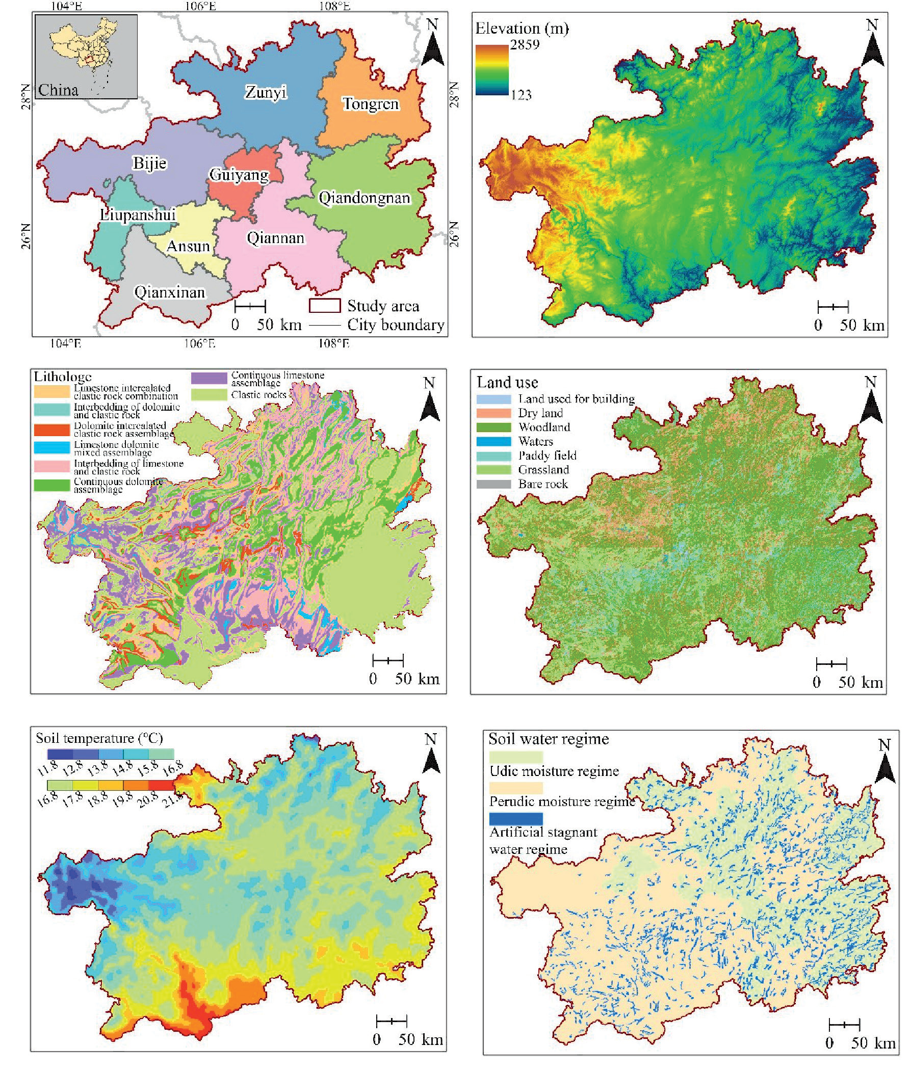
Guizhou Province is east of the Yungui Plateau, with a geographical position between 24°37′-29°13′ north latitude and 103°36′-109°35′ east longitude. It is an inland mountainous province. The province’s total land area is 17.62 km2, of which mountains and hills account for 92.5%. The terrain is high in the northwest and low in the southeast, with rolling terrain and crisscrossing mountains, with an average elevation of approximately 1100 meters. The karst landform is typical and comprehensive here. It has a humid subtropical climate with an average annual temperature between 10-20ºC and a yearly rainfall of 1100-1300 mm [28]. The parent rocks, land use patterns, soil temperature regimes, and soil moisture regimes are shown in Fig. 1.
Research Methods
Spatial Autocorrelation Analysis
(1) Global Moran’s I
There is a specific correlation between the observed values in geographical space and the experimental values in their adjacent areas. In this study, we used the global Moran’s I to analyze the autocorrelation of soil pH. The calculation formula is as follows [29]:
where xi and xj are the measured values at positions i and j, respectively (g · kg-1); x̅ is the average value (g· kg-1); Wij is the weight matrix of space; and N is the number of samples.
The global Moran’s I is between -1.0 and 1.0. If it falls between 0 and 1, there is a positive correlation. Namely, objects with similar qualities cluster together. If it is between 0 and -1, there is a negative correlation. That is, objects with different feature groups. The closer the absolute value is to 1, the stronger the autocorrelation is. The closer it is to 0, the more random the distribution. I is normalized to Z to judge the significance of the correlation. When |Z|>1.96, there is significant autocorrelation.
(2) Getis-Ord Gi*
Based on the global correlation analysis, we will further use Gi*(d) to characterize the high-value cluster areas (hot sites) and low-value cluster areas (cold sites) of soil pH. They are displayed in space to reveal pH diversity. The calculation formula for [30]:
The standardized statistic of the Gi*(d) test is as follows:
where xi is the soil pH of a coordinate point and Wij is the weight between point i and point j in the area. EGi* and VAR(Gi*) respectively express the mathematical expectation and coefficient of variation. If Z(Gi*) is significantly positive, the i area is a hot site with high pH, whereas it is a cold spot area.
Semivariance Model
We used semivariance for analysis to quantify the influence of structural and random factors on the varying soil pH. The nugget (C0) shows random variation. The sill (C0+C) appears in a total variation, and the range offers the scale range of variation. The nugget coefficient (C0/(C0+C)) shows the proportion of random variation, which reflects the degree of autocorrelation. The self-correlation is vital when the nugget coefficient is less than 25%. It ranged from 25% to 75% and was moderate. More than 75% is considered weak. When the nugget coefficient is less than 50%, structural factors dominate the variation. See references for its calculation formula [31].
Geographical Detector
A geographic detector is a spatial analysis model. It detects differentiation and reveals the relationship between a particular geographic feature and its explanatory causes. It can see the influence of a single cause and double causes on the dependent and statistically test its significance [27]. In this paper, we will use cause detection and interaction detection to analyze the influence of each reason on soil pH.
(1) Factoe detection
The influence of a driving factor X on the dependent variable Y (soil pH) is quantified by the q value. The degree of spatial differentiation of soil pH is described by the extent that a certain driving factor X is detected. The formula for calculating q is as follows [32]:
where Nh is the number of units in subcell type h, N is the number of units in the entire area, σh2 is the variance of pH in subcell type h, and σ2 is the variance of pH in the entire area.
q is the degree to which a certain cause explains power. In addition, it ranges from [0,1]. If q is larger, the reason has greater explanatory power for pH and vice versa.
(2) Interactive detection
Based on cause detection, we superimposed two cause layers. Calculate the q of X1∩X2. Finally, we analyzed q(X1), q(X2), and q(X1∩X2) to judge their interaction, as shown in Table 1 (http://www. geodetector.cn/).
Data Source and Processing
Data Sources
From 2017 to 2019, we collected soil samples (excluding construction land, water area, and bare rock texture) in Guizhou Province, according to a grid of 500 m×500 m, and the sampling depth was 0~20 cm. We observed the latitude and longitude coordinates, parent rock types, land use patterns, altitude, and other information during sampling. Then, after air drying, grinding, and sieving, the soil samples were indoors. We measured pH by the electrode (water-soil ratio 2.5:1).
Data Processing
After using the “3 times standard deviation method” to remove outliers, we finally obtained 394,736 valid sample data. We converted the data to a near normal distribution. We completed descriptive statistics, normal distribution transformation, and nonparametric tests in SPSS 22. Global Moran’s I analysis by GeoDa1.14. Geographic detectors in the R program. Getis-Ord Gi* analysis and kriging interpolation analysis in ArcGIS10.6. We performed conventional statistical analysis and drawing processing in Excel 2016 and Origin 2017, respectively.
Results and Discussion
Spatial Distribution of Topsoil pH
We obtained the topsoil pH distribution in Guizhou by kriging method interpolation (Fig. 2). The distribution diagram showed that the surface soil is mainly acidic, with slightly acidic soil (5.5~6.5) and (strong) acidic soil (pH<5.5) accounting for 72.19% and 11.71% of the total soil area, respectively. Neutral soil accounts for 15.23%. Slightly alkaline (7.5<pH<8.5) and alkaline soils (pH>8.5) accounted for only 0.87%. From the distribution law, pH showed certain patchy mosaic distribution characteristics. In most areas, slightly acidic soil spreads continuously, with acidic and neutral soil settings. However, a few slightly alkaline soil sets in neutral soil.
Table 1.
Results of the interaction between two factors.
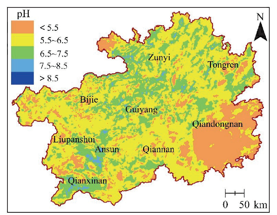
With the variety of biological and climatic factors, the soil pH distribution has the regularity of “acid in the southeast and alkali in the northwest” in China. The boundary is roughly the Yangtze River (33°-35°N). The soil south of the Yangtze River is acidic or strongly acidic, while the soil north of the Yangtze River is mainly neutral or alkaline [33]. In this study, the pH ranged from 3.11 to 8.99, with an average value of 6.16, showing weak acidity. Additionally, the distribution frequency of samples (Table 1) shows six types: strong acid soil, acid soil, slightly acid soil, neutral soil, slightly alkaline soil, and alkaline soil. The soil with pH<6.5 was the highest type, accounting for 64.76% (Table 2). Therefore, the pH characteristics in Guizhou Province must conform with the general features of soil acidity and the geographical distribution pattern of China.
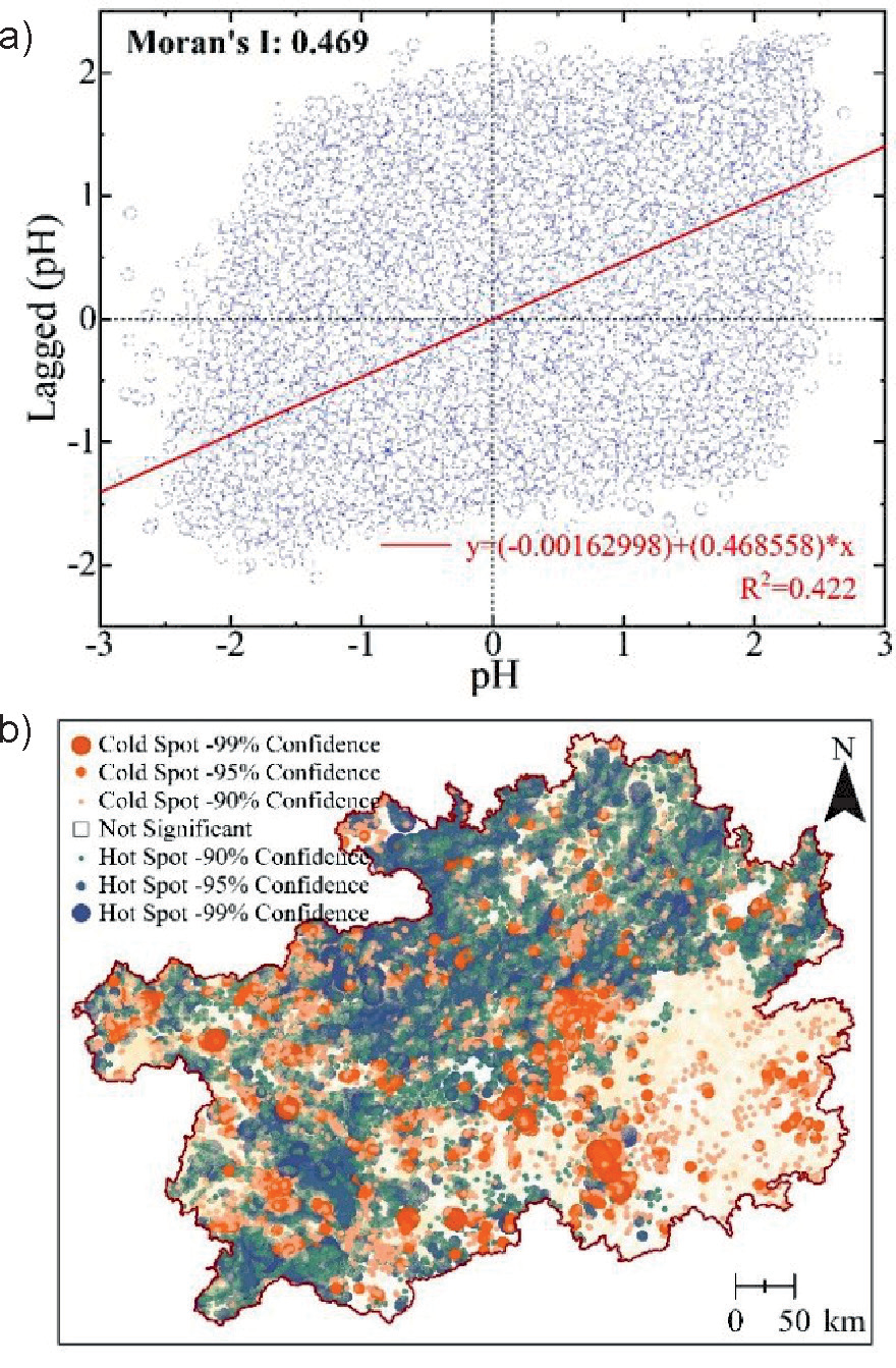
From the distribution law, slightly acidic soil (5.5<pH<6.5) is present in most areas of the province, accounting for 72.19% of the total land area in the study area (Table 2), and acidic soil mainly spreads in patches. Some regions in southeastern Guizhou (such as Qiandongnan Prefecture), southern Guizhou (such as Qiannan Prefecture), and western Guizhou (such as Bijie Prefecture) were cold spots with low pH values, especially in southeastern Guizhou. Hot spots with high pH values were in parts of the northeast to southwest of Guizhou Province. Neutral soil lay in slightly acidic soil in block form, and a few alkaline soils lay in neutral soil. Surface soil with different acidities in Guizhou Province showed a patchy mosaic distribution pattern in space.
Analysis of Spatial Structure Characteristics
Soil is the product of many causes, such as climate, parent material, biology, topography, time, and humans. Its variation also reflects the difference in the comprehensive action of various natural and human causes. Structural factors (climate, parent material, and topography) will lead to solid autocorrelation of soil properties. In contrast, random reasons (such as fertilization, tillage measures, planting, etc.) will develop toward homogenization [15]. Moran’s I was 0.469. Z was 530.26, and P was 0.001 (Fig. 3a) on topsoil pH. All these have proven to be a significant positive correlation and show the aggregated distribution. Some areas in the northeast to southwest of Guizhou Province are mainly hot spots with high pH(Fig. 3b). Some southeast, south, and west areas are mostly cold sites with low pH. Additionally, some small local areas are insignificant.
Table 2.
Descriptive statistics of soil pH.
| Samples | Min | Max | Mean | SD | CV/% | Distribution frequency of pH samples /% | |||||
|---|---|---|---|---|---|---|---|---|---|---|---|
| 3.5~4.5 | 4.5~5.5 | 5.5~6.5 | 6.5~7.5 | 7.5~8.5 | 8.5~9.5 | ||||||
| 394736 | 3.11 | 8.99 | 6.16 | 1.06 | 17.14 | 1.44 | 31.21 | 32.11 | 19.62 | 15.48 | 0.14 |
Table 3.
Theoretical variogram model and related parameters of pH.
The variation coefficient (17.14%), global Moran’s I (0.469), and lump gold coefficient (47.52%) in this study all showed that the surface soil pH has moderate variation and autocorrelation. Both structural factors and random factors determine the difference. Because the nugget coefficient was less than 50%, structural reasons dominate the variation (Table 3). This is consistent with the differentiation characteristics of soil pH in Guangdong Province [34] and England and Wales [35] with similar research scale.
Analysis of Influencing Factors
There were significant differences in soil pH under different soil moisture regimes (H = 423.164, P<0.001), soil temperature regimes (H = 4452.415, P<0.001), parent rock types (H = 43314.756, P<0.001), land use patterns (H = 2410.345, P<0.001) and altitudes (H = 5863.543, P<0.001) (Fig. 4). Based on the Bonferroni multiple mean comparison results, the differences are as follows: udic > perudic, artificial stagnant water; hyperthermic> thermic> mesic; carbonates > terrigenous siliceous clastic rocks > magmatite >layered regional metamorphite; 90-1400 m > below 900 m > 1400-1900 m>1900 m; cultivated land > grassland > garden land and woodland.
The results of factor detection showed (Table 4) that the order of q is parent rock > altitude > soil temperature regime > land use > soil moisture regime (P<0.01). The interaction says that the joint action of any two reasons will increase the explanatory power. The relationship between parent rock and altitude was the most powerful (0.125), while the relationship between land use and soil moisture regime was the least powerful (0.006).
The parent material is the result of weathering of rocks and minerals on the surface of the Earth’s crust. In this study, parent rocks include carbonates, terrigenous siliceous clastic rocks, magmatite, and layered regional metamorphite. As the parent material is the basis of soil formation and development, soil properties inherit the parent material characteristics. Therefore, the difference in mineral composition and physical and chemical properties of the parent rock directly influences the pH of the soil formed [11], and soil pH changes with the parent rock [14]. Guizhou enjoys subtropical humid monsoon climates with plentiful rain that causes the intense leaching of base ions. Therefore, the exchangeable cations in the soil are mainly acid ions (H+ and Al3+), and the soil is mostly acidic. In this study, the soil was mainly acidic, developed in terrigenous siliceous clastic rocks, magmatic rocks, and layered regional metamorphic rocks. Soil developed in carbonates experienced substantial chemical dissolution and carbonate leaching during formation. Therefore, the pH of carbonate-developed soil was significantly higher than that of another parent rock-developed soil (P<0.05). Additionally, the geographical detector results showed that the parent rock’s q was the most important (0.0976).
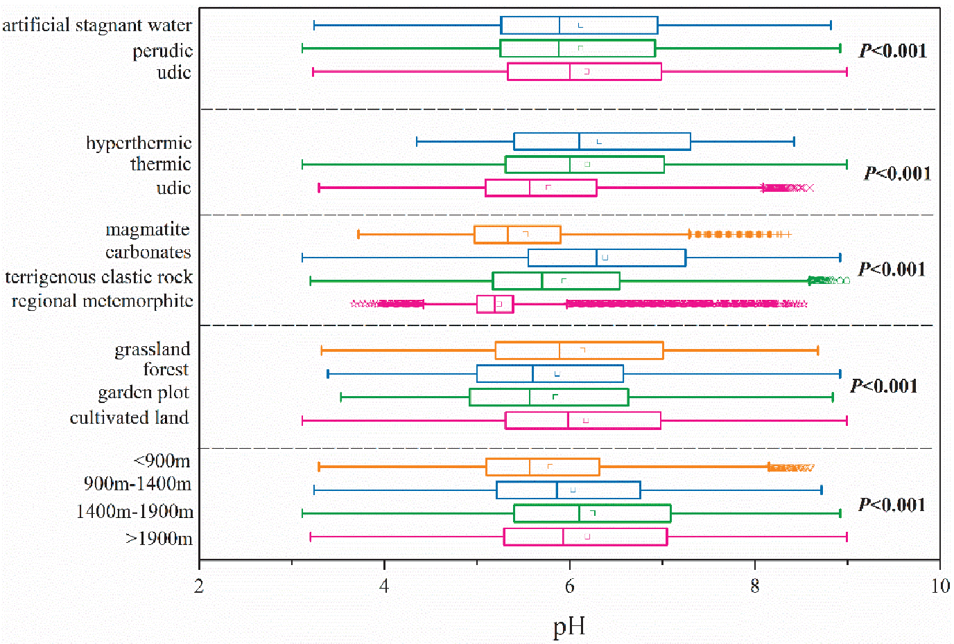
Table 4.
Geographical detection of factors affecting the factors of topsoil pH variation 1)
Topography causes the redistribution of surface water thermal conditions, parent materials, or soil substances. Altitude is a part of the principal topographic factors. Differences in temperature, rain, parent material types, and soil material composition exist in different altitude regions. All this will lead to the difference in the animal, plant, and microbial species. Then, various chemicals will change in the soil. Eventually, the soil pH will change in response [22]. Guizhou is on the step-like slope zone of the Yungui Plateau. The terrain is high in the west and low in the east, showing a three-step decline. This study has many differences in soil pH at different altitudes (P<0.001). At altitudes greater than 1900 m, the average pH value is 5.79. The proportion of (strong) acidity (pH<5.5) was relatively high. Therefore, the pH was significantly lower than that of other altitude areas. This shows that the soil in the high-altitude area is more acidic, which is consistent with the research results of Deng [11]. In addition, the geographical detector results show that the altitude q was 0.0144, which was smaller than that of the parent rock.
The principal climatic variables influencing soil are the effective precipitation and temperature, both of which affect the rates of chemical, physical, and biological processes [36]. The soil moisture regime and soil temperature regime can characterize them. This study showed pH differences among hyperthermic, thermic, and mesic (P<0.001). Significant differences existed between udic, perudic, and artificial stagnant water (P<0.001).
Land use patterns reflect factors such as management level and decision-making, which can affect plant litter and residues, microbes, the flow of soil substances, and the retention and transformation of essential chemical parts in different land units [18, 37]. Under different land use patterns, soil pH also shows noticeable differences [2, 16]. In this study, there were significant differences among cultivated land, grassland, garden land, and forestland (P<0.001). Because vegetation types are mainly woody in woodlands and gardens, their ash content was low. After litter decomposes, fulvic acid is primarily the product. Therefore, most soil is (strongly) acidic [38]. The litter of herbaceous plants has higher ash, so the soil pH is high. Arable land is agricultural soil. Flooding, fertilization, improvement, and crop roots all affected its properties. Soil changes to a neutral reaction. Most are slightly acidic or neutral. Geographical detection results showed that the land use pattern also significantly affects that pH, and its q was 0.00503.
The varying pH in Guizhou Province results from the comprehensive action of many factors, such as parent rock, altitude, land use pattern, soil temperature, and soil moisture. The parent rock and altitude had the greatest q (0.0976 and 0.0144, respectively), and the q of their interaction was larger (0.125). Therefore, the parent rock and altitude are the main control factors of soil pH variation. However, the detection results of cold spots (Qiandongnan, Qiannan, and Bijie) differ from the overall results of Guizhou Province. Among them, parent rock and soil moisture regimes are the most potent explanation in Qiandongnan (0.4102). In Qiannan, parent rock and land use were the most powerful (0.0416). In Bijie, altitude and soil-forming parent rock were the most powerful (0.1174).
Conclusion
(1) The soil pH varied from 3.11 to 8.99, with an average value of 6.16. There are six types: strong acid soil, acid soil, slightly acid soil, neutral soil, slightly alkaline soil, and alkaline soil. Soil with pH<6.5 was the most abundant. The soil pH characteristics in Guizhou Province conformed with the general features of soil acidity and the geographical distribution pattern of China.
(2) Soil pH shows aggregation distribution. Hot sites concentrate on the line from the northeast to southwest of Guizhou, while cold spots focus on the southeastern, southern, and western areas of Guizhou Province. Both structural factors and random factors control pH differentiation, but structural factors play a determinant role. Soil pH mainly shows a patchy mosaic distribution pattern. In most areas, slightly acidic soils exhibit a concentrated distribution pattern but are often inlaid with acidic and neutral soil.
(3) Parent rock is the determinant factor controlling the surface soil pH differentiation in Guizhou Province. However, the combined effect of parent rock and altitude should be considered in the whole province scale. In a local scale, the interactions between parent materials and the soil moisture in Qiannan, parent materials and land use patterns in Qiandongnan play remarkable roles on soil pH.

