

Introduction
Wetlands are important ecosystems formed by the interaction between terrestrial and aquatic environments. They are often referred to as “Earth’s Kidney” due to their critical ecosystem services for human beings [1]. Wetlands offer a unique natural landscape with numerous benefits for humans. They play a crucial role in managing floods, regulating the climate, purifying water, preserving biodiversity, enhancing the aesthetic appeal of the environment, and providing habitat and cultural services, all of which contribute significantly to both ecology and economic development [2]. However, the development of the social economy and the rapid pace of urbanization have resulted in varying degrees of damage to wetland ecosystems, including reduced biodiversity, deteriorating river water quality, and the shrinkage of wetland areas [3]. If these ecological and environmental problems persist, they will pose a threat to the ecological security of river basins and may even limit human development [4].
The health assessment of wetland ecosystems requires a comprehensive evaluation of the socio-economic-natural complex system. This evaluation considers the overall interaction between wetland systems and human activities in human-dominated terrestrial ecosystems [5]. This evaluation has gradually been applied to the management and health diagnosis of wetland ecological regions, the health status of wetland ecosystems, the measurement of wetland ecosystem service functions, and the quantification of wetland protection standards [6, 7]. A health assessment of wetland ecosystems can assist in diagnosing disruptions in internal material or energy balances, caused by natural factors or human activities. It provides an early warning of potential ecological function losses and offers a scientific basis for managers and decision-makers to formulate or adjust management and protection strategies, thereby promoting the sustainable utilization of wetland resources [8]. In addition, effective health management of wetland ecosystems can sustain and enhance ecosystem services by implementing targeted conservation and restoration strategies.
Methods of wetland ecosystem health assessment based on the index of biotic integrity (IBI), indicator species, and the ecological health comprehensive index (EHCI) have been established and are widely applied in various wetland health assessments. Karr applied the fish IBI to evaluate the quality of lakes in the USA [9]. Lu Kangle and Xiao Keyin [10, 11] evaluated the health status of marsh wetlands in the Sanjiang Plain and Suzhou wetlands by constructing aquatic invertebrate integrity indices and avian biological integrity indices respectively. Xiong Jing et al. [12] conducted a health assessment of the Kuilei Lake area by applying the family biotic index (FBI), biotic index (BI), and biodiversity indices. However, it is difficult to reflect the wetland ecosystem health status accurately when using the IBI, particularly in wetland ecosystems with large temporal and spatial watershed scales.
To address the limitations of the IBI method, an alternative ecosystem health assessment approach known as the EHCI has been proposed. The EHCI is a comprehensive health index system with multiple levels and indicators that can quantitatively assess and compare the ecological health status of wetland systems [13]. Li et al. [14] proposed an improved catastrophe theory (ICT) combined with the analytic hierarchy process (AHP) and the entropy weight method (EWM), to evaluate the evolutionary trend of the wetland degradation risk in Xiong’an New Area from 2000 to 2020. Wang et al. [15] established important indicators to systematically evaluate the health status of the Cuihu wetlands’ ecosystem at three levels, through comprehensive evaluation methods, and proposed improvement strategies for the development of the wetland. Feng Qian et al. [16] selected 21 evaluation indicators from three subsystems, including the wetland natural environment, overall function, and social environment, and conducted a comprehensive analysis of wetland ecosystem health using a fuzzy comprehensive evaluation. Chen Feng et al. [17] constructed a wetland ecosystem health evaluation indicator system based on the pressure-state-response (PSR) model and evaluated the health of the coastal wetland ecosystem in the eastern part of Fujian Province. Furthermore, methods such as the entropy weight method, Delphi method, three-level evaluation model, grey model, backpropagation (BP) neural network model, projection pursuit model, the technique for order of preference by similarity to ideal solution (TOPSIS) model, and rough set theory model have also been applied in the comprehensive evaluation of wetland health [18, 19]. However, the PSR model has become one of the most widely used indicator system selection frameworks due to its ability to provide an effective indicator classification scheme, accurately reflect the ultimate goals of wetland managers, and facilitate dynamic evaluations [20].
National wetland parks play an active role in maintaining the integrity of wetland ecological functions, enhancing ecosystem resilience, activating the ecotourism economy, and promoting awareness of wetland protection through environmental communication. Conducting wetland ecological health assessments on these parks can provide effective information and a scientific basis for evaluating wetland environmental conditions, discriminating wetland functions, improving wetland management quality, and developing scientific protection methods [21]. The Shandianhe Wetland is located on the migratory route of several bird species between East Asia and Australasia. It also stands at the intersection of the animal faunas of North China, Mongolia-Xinjiang, and Northeast China, serving as a convergence point for birds migrating north-south and east-west, and providing a stopover for various rare and endangered birds. However, with the increasing level of human activity around the wetland and the decline in water flow capacity, several issues have emerged in the Shandianhe Wetland under the influence of marginal effects, including deteriorating water quality, shrinking wetland area, and reduced hydrological connectivity, leading to a state of ill-health [22]. Consequently, in 2015, the Shandianhe National Wetland Park (SNWP) was designated one of the 23 national wetland parks prioritized for construction in Hebei. A few years after its establishment, the Shandianhe Wetland emerged as the closest and best-preserved plateau wetland to Beijing and Tianjin, and has become known as the “Water Tower of Beijing and Tianjin”. It serves as an important ecological barrier in the Beijing-Tianjin region and is a critical component of the country’s wetland network [23]. However, the Shandianhe wetlands still face numerous threats, with the ecosystem being fragile and highly susceptible to losing its functionality.
This study evaluated the ecosystem health of SNWP based on the PSR model, combined with a hierarchical analysis and fuzzy comprehensive evaluation. The aim of the study was to identify key factors affecting ecosystem health through a health assessment of the wetland ecosystem in the wetland park. This will provide a scientific basis for the healthy development of the SNWP and reliable data support for improving the monitoring and protection management level of its wetland resources.
Materials and Methods
Overview of the Study Area
Located on the southern edge of the Inner Mongolia Plateau in China (115°44′−115°51′E, 41°37′−41°48′N), the SNWP is the nearest and most well-preserved plateau wetland to Beijing and Tianjin. It serves as a crucial ecological barrier in the region surrounding Beijing and Tianjin, and is one of China’s most important wetlands. The total area of the park is 41.20 km2, with wetlands covering 33.72 km2, accounting for 81.8% of the total area. The types of wetland, landscapes, and biodiversity in the park are representative of the Plateau region of China, and include rivers, lakes, marshes, and artificial reservoirs. The maximum temperature in the study area is 33.5ºC, with a minimum of -40.3ºC, and an average annual temperature of 2ºC. The annual precipitation is around 300 to 400 mm, while the annual evaporation is approximately 1700-1800 mm. Shandianhe Wetland is rich in biological resources, hosting over 300 species of wild plants belonging to 61 families and 201 genera, as well as 222 species of terrestrial vertebrates and 274 species from 68 families. Among them, birds were the most diverse, with 17 species categorized as national level I key protected wildlife, including Ciconia boyciana, Larus relictus, Ciconia nigra, Otis tarda, Mergus squamatus, and Aquila chrysaetos. In addition, the park contains 38 species categorized as national level II key protected wildlife, including Cygnus olor, Cygnus columbianus, Anser cygnoides, Bubo, and Grus grus.
Data Sources
The data sources primarily consisted of four categories: statistical data, field sampling data, remote sensing data and products, and questionnaire survey data.
Statistical data: This included population, GDP, and water resource development and utilization rate. These data were obtained from government websites, such as the Guyuan County Bureau of Statistics, Guyuan County Ecological Environment Bureau, National Meteorological Science Data Center, and Guyuan County Water Affairs Bureau. Some additional monitoring data were purchased from relevant bodies;
Field Sampling Data: Surface water quality and soil heavy metal pollution levels had been determined through field sampling and monitoring.
Remote Sensing Data and Products: Remote sensing interpretation had been used to obtain landscape pattern data for various land use types within a 1 km radius of the wetland. These data were then used to calculate vegetation coverage, wetland area, and degraded wetland area.
Questionnaire Survey Data: Questionnaires had been distributed to residents around the Shandianhe wetland to assess their awareness and attitudes towards wetland protection, as well as the enforcement of relevant policies and regulations. These surveys were conducted online through a questionnaire platform, and a total of 111 valid responses were collected.
Health Evaluation Methodology
The PSR Model of the SNWP
Based on the PSR model, index selection should consider the ecosystem service function, human activities, and human social and economic status. Taking into account the climate characteristics of the Inner Mongolia Plateau and the actual situation of the Shandianhe Wetland, based on principles such as integrity, representativeness, and accessibility, and considering the characteristics of ecosystem structure and function, as well as the influence of economic, social, and policy regulations, an evaluation index system was constructed as below Fig. 1.
Pressure indicators were chosen to highlight both the indirect and direct driving forces behind environmental issues. These included population density, gross domestic product (GDP), drought severity level, grazing pressure, water resource development and utilization rate, number of tourists, and the invasion of alien species. Each of these indicators was selected due to their significant impact on the wetland’s ecological balance and their measurable attributes which are critical for quantifying the extent and nature of pressures on the wetland.
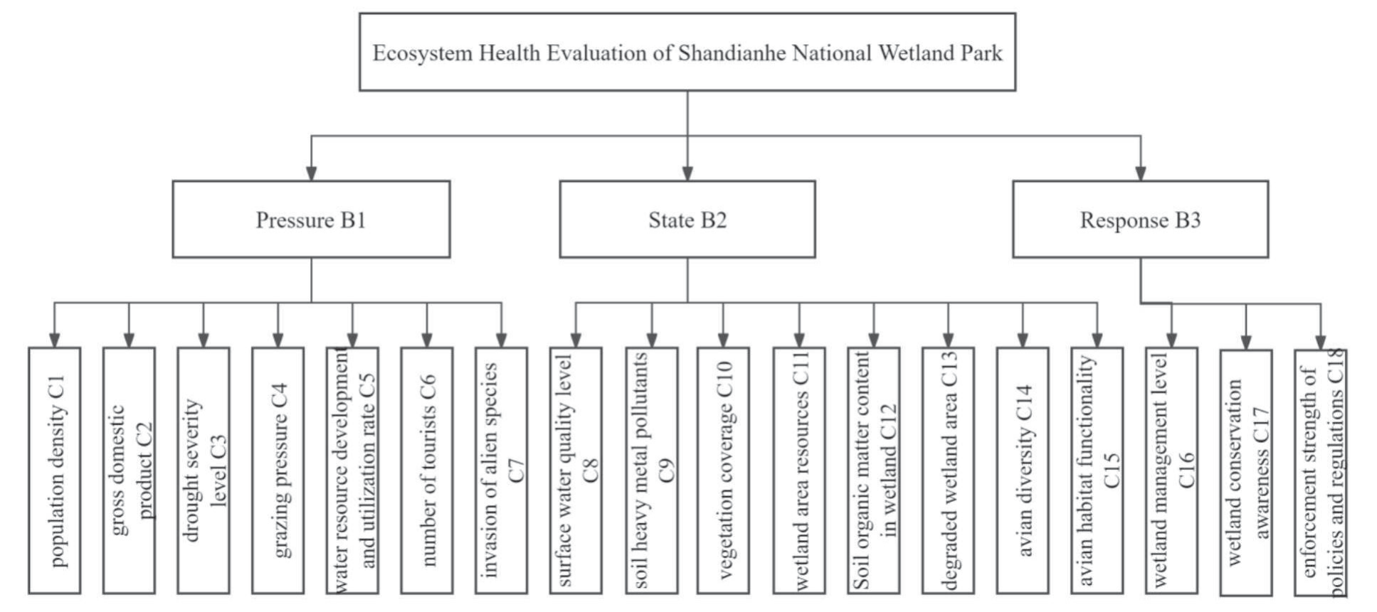
State indicators are intended to reflect and describe the composition, structure, and function of the wetland ecological system. These encompass surface water quality level, soil heavy metal pollutants, vegetation coverage, wetland area resources, organic matter content in wetland soil, degraded wetland area, avian diversity, and avian habitat functionality. The selection of these indicators was based on their ability to provide a holistic view of the wetland’s health and their direct relevance to the ecosystem’s integrity and resilience.
Response indicators focus on societal and individual efforts to mitigate the environmental changes that affect human survival and development, reflecting the commitment of human society to sustain and enhance the wetland ecological systems. Selected indicators include wetland management level, wetland conservation awareness, and the enforcement strength of policies and regulations. These were chosen for their potential to demonstrate the effectiveness of conservation efforts and policy implementations, along with their impact on improving management practices.
Determination of Indicator Weights
An AHP was applied to determine indicator weights. Developed by Thomas L. Saaty in the mid-1970s, the AHP is a systematic method for system analysis [24]. It is a structured approach designed for the organization and analysis of intricate decision-making processes. Based on the AHP model, a questionnaire was distributed to 15 experts from the Wetland Research Institute of the Chinese Academy of Forestry Sciences, Hebei Agricultural University, Hebei Normal University for Nationalities, and the SNWP management personnel. Through a face-to-face consultation, the experts were asked to compare the relative importance of each of the two indicators and assign scores according to the judgment matrix 1-9 scale (Table 1). This process determined the final weights of the evaluation indicators. The larger the proportion of the weight value, the greater the impact of that indicator on the health of the ecosystem [25].
A consistency check for the weight values of each evaluation indicator was conducted using the following formula:
In the formula, λmax represents the maximum eigenvalue, and RI is obtained by referencing the consistency check RI value table. The calculated CR is compared with 0.1, and the consistency of the judgment matrix is acceptable when the CR value is <0.1. In this study, all matrices passed the consistency test. The weights of the health assessment indicators are shown in Table 2.
Data Preprocessing and Standardization
Based on the aforementioned evaluation index system for wetland ecosystem health, it was necessary to determine a specific value for each indicator and further categorize each indicator into standardized evaluation grades to describe wetland health. Using a wetland ecosystem health evaluation grade classification, the evaluation of each indicator was divided into five grades: relatively healthy: generally healthy, sub-healthy, unhealthy, and seriously unhealthy. The expert scoring method was adopted, with the five evaluation grades represented by the numerical values of “5”, “4”, “3”, “2”, and “1”, respectively, indicating the score corresponding to the respective range of each indicator. By referencing the “International Standard for Soil Texture Classification”, “Regulations for the Classification and Grading of Agricultural Land”, “Water Quality Standards for Farmland Irrigation”, and other relevant standards, the range of values for each indicator was determined. The specific details are presented in Table 3.
Table 1.
The judgment matrix 1-9 scale method.
Table 2.
Weights of the indicators.
Calculation of the Health Index
The multi-objective linear weighted function method was used to calculate the pressure layer, state layer, response layer, and comprehensive health index of the SNWP. The calculation was as follows:
where, CHI is the comprehensive health index of the ecosystem; Ij is the standardized value of the jth evaluation indicator; Wj is the weight of the jth evaluation indicator; and n is the number of evaluation indicators.
Table 3.
The range of the reference values for the health grade of each indicator.
Evaluation Criteria
Based on the actual conditions of the SNWP and the published literature regarding the health of wetland parks, a comprehensive analysis was conducted in accordance with national, governmental, and local standards, with reference to the relevant literature. The ecosystem health index was then categorized into five health grades: relatively healthy, generally healthy, sub-healthy, unhealthy, and seriously unhealthy. The specific grading criteria for each evaluation indicator are detailed in Table 4.
Results
After obtaining the values of the evaluation indicators for the current status of the SNWP from multiple data sources, combined with the weights of each indicator, the comprehensive health value of the wetland was calculated as 3.4177, indicating that the health status of the wetland park is at a “sub-healthy” level. From the perspective of the criterion level, the health index scores for the pressure layer (B1), state layer (B2), and response layer (B3) were 2.2397, 3.9048, and 3.2605 respectively (Table 4). Thus, the pressure status of the SNWP is considered “unhealthy”, while the state and response statuses are classed as “sub-healthy”. The calculated weight values for B1, B2, and B3 were 0.2134, 0.5821, and 0.2045, respectively (Table 5), indicating that the wetland state had the strongest influence on the health of the SNWP, followed by the pressure and response factors.
Pressure Factors
Among the indicators of the pressure layer, grazing pressure (0.4219) was assigned the highest weight followed by drought severity level (0.2455) and water resource development and utilization rate (0.1453). This suggests that grazing, drought, and water resource utilization are important limiting factors affecting the health of the SNWP.
The indicators showing the highest health levels within the pressure layer of the SNWP included population density, GDP, number of tourists, and the invasion of alien species. Conversely, the indicators with the lowest health levels are drought severity, grazing pressure, and water resource development and utilization rates. Guyuan County, where the SNWP is located, has a population density of 43.51 people per km2 and a GDP of 7.61 billion yuan. In recent years, drought caused by insufficient rainfall in this region has been the most common and widespread meteorological disaster affecting the area. Years of drought have led to the severe degradation of wetland grasslands; however, some herdsmen continue to graze, resulting in a continuing decline in the quality of wetland grasslands. Grazing is strictly prohibited within the SNWP, but because the region is a mix of agricultural and pastoral areas, grazing remains an important threat to the wetland. Guyuan County is home to three major river systems: the Chaobai River, the Luan River, and the Hulu River. The total surface water resources amount to 73.81 million m3, with a utilizable volume of 24.19 million m3. The total groundwater resources are 130 million m3, with an exploitable volume of 49.49 million m3. Currently, the utilization rate of surface water resources is only 5.25%. In recent years, Guyuan County has developed its ecotourism industry, and the SNWP has become an important local tourist attraction, attracting 3.22 million tourists annually.
Table 4.
The classification of the CHI for the SNWP.
Table 5.
The health assessment results for the SNWP.
State Factors
Among the indicators of the state layer, wetland area resources (0.3657) had the highest weight, followed by degraded wetland area (0.2330) and vegetation coverage (0.1554). This indicates that wetland area resources, degradation of the wetland area, and vegetation coverage are important indicators of the health of SNWP.
Among the indicators of the state layer, those at the “healthy” level or above included soil heavy metal pollutants, wetland area resources, soil organic matter content in the wetland, and the degraded wetland area. The indicators below the healthy level were the surface water quality level, vegetation coverage, avian diversity, and avian habitat functionality. Field surveys or laboratory analyses of water, soil, and vegetation samples from the SNWP have revealed that the overall surface water quality of the wetland was Grade III. The comprehensive soil organic matter content was Grade III for 41.96% of the total area, with Grade II and Grade IV classifications accounting for 27.72% and 25.00% of the total area, respectively. The organic matter content in the mountainous areas along the dam edge and in the basins of the Shandian River and Hulu River was generally higher than in other regions. The comprehensive environmental quality of soil heavy metal pollutants was mainly Grade I, indicating a risk-free area that accounted for 99.95% of the total area, while the Grade II controllable risk area accounted for only 0.05% of the total area. The primary heavy metal contaminant was cadmium. The vegetation coverage within the wetland was 25%. The SNWP is located on the East Asia-Australasia bird migration route and is situated at the intersection of the animal faunas of North China, Mongolia-Xinjiang, and Northeast China. It is a convergence zone for bird migrations both north-south and east-west, as well as a stop-over site for various rare and endangered bird species. During the migration season, the total number of water birds can exceed 50,000, including eight species classified as either vulnerable, endangered, or critically endangered.
Response Elements
Among the response layer indicators for the SNWP, wetland conservation awareness (0.6334) had the highest weight, indicating its significant impact on the health of the SNWP.
A questionnaire survey was conducted among residents around the SNWP, and a total of 111 questionnaires were collected. Based on the survey results, the wetland management level scored 68.5 points, public awareness of wetland protection scored 50.5 points, and policy enforcement scored 58.5 points. This indicated that in terms of the response indicators, the wetland management level was in a healthy state, while wetland conservation awareness and the enforcement strength of policies and regulations were both in a sub-healthy state. The awareness of the relevant administrative departments and the public living around the SNWP therefore needs to be improved regarding the importance of the wetlands, and they need to actively participate in the protection of the local wetland resources.
Discussion
The intricate relationships among various components within different types of wetlands, as well as between wetlands and their environmental, social, and economic contexts, determine the multi-indicator nature of wetland ecological health assessments [26, 27]. It is therefore difficult to develop a systematic and standardized evaluation system.
The PSR model was initially proposed by the statisticians Tony Friend and David J. Rapport and was later modified by the Organization for Economic Co-operation and Development (OECD) in the 1970s for use primarily in environmental reporting studies. In the early 1990s, the OECD evaluated the validity and adaptability of the PSR model through an analysis of key ecological and environmental indicators. The PSR model addresses three fundamental questions: “what happened, why it happened, and how to solve it,” and has been embraced by millions of researchers [28]. In particular, it creates an analytical framework that compares the indicators of the PSR of the evaluation object with standardized reference standards. The model has been widely used in the study of specific environmental indicator systems, such as hydrology and water resources, regional environments, and natural wetland resources. Chinese researchers based on their own objectives and the PSR model, have established corresponding indicator systems from multiple perspectives and conducted health assessments of various types of wetlands, including the Poyang Lake wetland [29], the wetland in the middle reaches of the Heihe River [30], the Mindong coastal wetland [31], the wetland in the Sanmenxia Reservoir Area [32], the Gahai wetland in southern Jiangxi [33], the wetlands on the Yunnan-Guizhou Plateau [34], and the Kolkata wetland [35].
The SNWP is located in a continental monsoon climate zone, and is characterized by cold, windy, and arid conditions. With relatively low precipitation over a long period, its ecosystem is extremely fragile. Therefore, protecting the SNWP is of utmost importance for safeguarding the ecological environment and water resource security in the Beijing-Tianjin-Hebei region. To effectively address these challenges, it is recommended to implement advanced water resource management systems and promote public awareness campaigns to increase community involvement in conservation efforts. These strategies directly respond to the pressing issues such as drought and low community engagement highlighted by the study findings.
Guyuan County has attached great importance to the protection of the SNWP, which has ensured that it maintains its primitive ecology. In 2014, a health assessment of important natural wetland ecosystems in Hebei Province was conducted, focusing on habitat structure, biological structure, production function, and ecological function. It was found that the Shandianhe Wetland was in an unhealthy state around 2014 due to the unsustainable exploitation and utilization of its natural resources, leading to degradation and making it difficult for the wetland to sustain itself. Artificial measures were needed to gradually restore it [22]. In light of these challenges, specific management strategies such as further restrictions on grazing within the wetland area should be considered. This will help mitigate the impact of human activities and support the restoration of the wetland’s ecological balance.
The present study determined that the Shandianhe Wetland is currently in a sub-healthy state, indicating that after 10 years of artificial intervention and protection measures, its health status has improved. However, there are still many constraining factors, with climate drought, grazing, and low vegetation coverage being the key factors limiting the wetland’s health. Future studies should attempt to develop reasonable countermeasures to address these constraints and further enhance the health of the Shandianhe wetland ecosystem.
This study comprehensively considered various factors related to the socio-economic, biological, physical, and chemical aspects of wetlands, and incorporated key functional indicators such as avian diversity, and avian habitat functionality into the health assessment. This approach demonstrated a certain degree of innovation in the selection of significant indicators. There were important differences in the water quality indicators of the Shandianhe wetland during the dry and wet seasons. The water quality during the dry season was mostly classed as Category III, while during the wet season, it was mainly Category II. With the implementation of wetland engineering projects, such as ecological embankments and trash racks, there will be significant changes in the values of the ecological indicators within the wetland. Therefore, using a suitable wetland ecological health assessment system, it will be necessary to update the evaluation results in a timely manner according to the changes in the current status of the evaluation indicators, providing effective references for managers and decision-makers in policy adjustments.
Conclusions
Based on the PSR model, a health evaluation index system for the wetland ecosystem of the SNWP was established. Using expert scoring and the AHP, the quantitative values and weight values of each indicator were determined. A comprehensive index method was then applied to calculate the overall health score of the wetland ecosystem, ultimately evaluating the health status of the ecosystem in this region.
1. The overall health status of the SNWP was sub-healthy, indicating a certain degree of improvement in its health status. However, due to the influence of recent climate conditions and human activities, the wetland ecosystem still faces many threats and pressures.
2. Based on the analysis of various factors in the target layer, the health status of both the state system and response system was sub-healthy, while the health status of the pressure system was unhealthy and close to being in the seriously unhealthy state. This suggests that the wetland ecosystem is facing considerable pressure.
3. A comprehensive analysis of the overall situation and individual factors indicated that the health of the Shandianhe wetland ecosystem was influenced by climate and human activities. Frequent droughts and human activities have made the wetland ecosystem vulnerable, leading to decreased vegetation coverage and a range of issues that have impacted the aquatic ecological environment.
The research results provide a reference and theoretical basis for studies of the health of the Shandianhe wetland ecosystem, as well as theoretical support for the government and administrative departments in developing protection and construction plans for the ecosystem.

