

Introduction
The new era’s territorial spatial planning emphasizes the importance of integrated land-sea planning, which involves combining multiple regulations and promoting the development of maritime power [1]. Approximately one-third of the global population lives within 150 kilometers of the coastline [2]. In mainland China, although coastal areas make up only approximately 13% of the total land area, they are home to 42% of the country’s population and contribute to more than 60% of the GDP [3]. These coastal areas are densely populated and face significant environmental challenges [4, 5]. Integrated land-sea planning can effectively address issues such as imbalanced spatial development between land and sea, conflicts among production, living, and ecological spaces, the unequal distribution of natural resources, and disparities in economic growth. Therefore, conducting suitability assessments for integrated land-sea planning is an essential measure for protecting the environment and promoting socioeconomic development.
In 1972, the United States Coastal Zone Management Act proposed rational spatial planning to reduce excessive exploitation of land and sea resources and minimize damage to marine resources. The ideal outcome of coordinated land-sea spatial planning in the UK is for all land-based spatial planning and policies to align with marine spatial planning and policies. Research by Li Yanping et al. suggests specific policy recommendations, such as developing and improving policy lists, enhancing technical methods, clarifying the focus of land-sea coordination at different levels and types of planning, improving interdepartmental collaboration mechanisms, and delineating core areas for land-sea coordination in coastal regions [1]. Zhao Jian et al. analyzed the problems in China’s county-level land spatial planning and proposed optimization suggestions such as strengthening detailed planning and pilot projects related to the sea and exploring the setting of land-sea compatibility zones [6]. Based on theoretical analysis, Ma Shimin et al. proposed evaluation indicators for land-sea coordination regarding resource and environmental carrying capacity [7]. Ji Xuepeng et al. established an indicator system for suitability evaluation in three dimensions – natural environment, economic and social factors, and marine functions – using methods such as the Delphi method, the barrel principle, the linear weighted sum method, and multifactor spatial overlay analysis [8]. Junyuan Zhao elucidated the spatial distribution patterns of ecological tourism suitability in Henan Province from an ecological perspective [9]. Oktawia Specht suggested that the kriging model is the best method for creating land and sea surface models [10]. Tong Xu developed a model for analyzing the suitability of farmland construction [11]. Ram Mohan proposed measures for coastal resiliency based on America’s four coasts [12]. Shiyong Wen classified Hazard Zoning of Harmful Algal Bloom using a qualitative method [13].
Previous research has extensively examined the development and utilization of land and seaspace from a holistic viewpoint. These studies have offered valuable insights for future investigations. However, most of these studies were either based on theoretical foundations or focused on single factors, lacking sufficient data support. The Yazhou Bay Coast Zone has undergone a suitability assessment for marine area development [14], but lacks research on the integrated suitability assessment of land-sea coordination. To address this gap, this study focused on the Yazhou Bay Coast Zone, utilizing previous investigation results and collected data. Evaluation indicators for land and sea areas are established from geological and environmental perspectives. Evaluation models are constructed using K-means clustering, the entropy weight method, the analytic hierarchy process, and the natural breakpoint method. The objective of this study is to comprehensively assess the suitability of engineering construction and development by integrating land and sea considerations. The findings of this research can provide policy recommendations for land and sea space planning and serve as a methodological reference for similar regional evaluations.
Overview of the Study Area and Data Sources
Overview of the Study Area
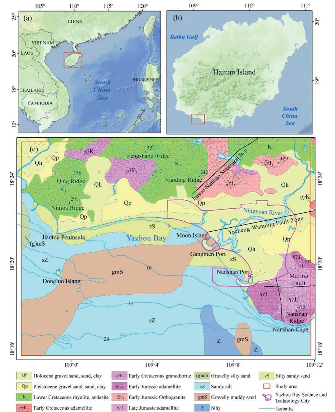
The study area is located in the southern part of Hainan Island, China. It includes Yazhou Bay Science and Technology City, which consists of key parks such as the Global Biotech Valley, South Breeding Science and Technology City, Deep Sea Science and Technology City, and the Global Introduction and Transfer Base for Animal and Plant Genetic Resources. This area serves as a model for developing the Hainan Free Trade Port, Constructing Moon Island, Gangmen Port, and Nanshan Port in the coastal area. The terrain in the area is higher in the north and lower in the south, with three prominent mountain ranges (NiuTou Ridge, NanDing Ridge, and NanShan Ridge) surrounding Yazhou District and creating a curved coastline. The Ningyuan River flows from northeast to southwest and converges into Yazhou Bay, forming a channel system of sandbars, marshes, and tidal zones in the estuary [15]. The surrounding area of the Ningyuan River is flat, and Yazhou Bay Science and Technology City is located in this area. The water depth in the southern part of the study area ranges from 0 to 25 m, gradually increasing from north to south. The slope is steeper at Nanshan Cape and Jiaotou Peninsula, where the sea depth rapidly increases, while the slope is gentler in other areas (Fig. 1).
The Ningyuan River area and the northern coastline are characterized by loose soil layers consisting of Quaternary Holocene and Pleistocene gravel, sand, clay, and other sediments; bearing capacity characteristic values range from 90 to 243 kPa. The Niutou Ridge, Qing Ridge, Fengshang Ridge, and Nanding Ridge are mainly composed of Lower Cretaceous rhyolite and andesite. Fractures are well developed, with a compressive strength ranging from 38 to 108 MPa. While the Nanshan Ridge contains Jurassic adamellite, the rock is of good quality and has a compressive strength ranging from 55 to 113 MPa. The sediments in the study area become finer as you move from the coastline to the sea. The central part of the bay is dominated by gravelly muddy sand (gmS); bearing capacity characteristic values range from 120 to 210 kPa, which forms a southwest-extending band from the mouth of the Ningyuan River. Sandy silt (sZ) is found on both sides of the gravelly muddy sand (gmS); bearing capacity characteristic values range from 90 to 150 kPa. While silty sand (zS) is distributed along the coastline, bearing capacity characteristic values range from 100 to 170 kPa. Silt (Z) is present in the nearshore area of Nanshan Cape; bearing capacity characteristic values range from 80 to 140 kPa. Gravelly muddy sand ((g)mS) is found only in the western sea area of the Jiaotou Peninsula; bearing capacity characteristic values range from 120 to 200 kPa [14].
No fault development was observed in the marine region of the study area. However, three fault zones are distributed in the land region, namely, the Jiusuo-NanHao tectonic zone, the Yacheng-Wanning fault zone, and the Malin fault zone. These fault zones experienced relatively intense tectonic activity during the Indosinian, Yanshanian, and Himalayan periods, which gradually decreased afterward. The development of new tectonic activity is relatively weak and is primarily characterized by geothermal activity, as evidenced by the presence of exposed hot springs (Fig. 1).
Data Sources
This study used slope, aspect, and terrain ruggedness data derived from a digital elevation model (DEM) obtained from the Geospatial Data Cloud website with a resolution of 30 m (https://www.gscloud.cn/). The high-risk areas for geological hazards were obtained from a map dataset on the Hainan Province Land and Space Basic Information Platform (https://yzlt.hniplan. com/login.html). Geological structures and formations were sourced from the 1:250,000 Geological Map of Hainan Island. Marine data were obtained from the “Comprehensive Geological Survey and Evaluation of the Coastal Zone of Hainan Island” project conducted by our organization from 2015 to 2017 using the WGS-84 coordinate system. Data processing and mapping were performed using SPSS and ArcGIS software.
Research Method
Selection of Influencing Factors
Various methods have been proposed in previous studies to select factors that influence the evaluation of land-sea coordination suitability. Ji Xuepeng et al. conducted a comprehensive analysis by incorporating marine functional zoning into the evaluation of land areas [8]. Feng Jianing et al. developed a unified set of influencing factors for qualitative analysis based on the classification scheme of land-sea spatial coordination [16], as well as the resource base and policy background of Nantong City. Building on previous research, this study focuses on the coordination between engineering construction and the natural environment, considering the significant differences in geological environments between land and sea. For the land area, the evaluation indicators include slope, aspect, topographic relief, distance to faults, and areas prone to geological hazards. For the sea area, the evaluation indicators include water depth, slope, sediment environmental quality, area of ancient river channels or lakes, area of sand waves, area of sand ridges, area of soft soil, and thickness of soft soil [14].
Land Influencing Factors
Analysis of the Slope Influence
The slope is a crucial factor in engineering construction. In our study area, the land slope ranges from 0 to 52.75°. The wings and northern side have steeper slopes, ranging from 5 to 52.75°. The western part includes the NiuTou Ridge and Qing Ridge, with slopes ranging from 4 to 50°. The northern part consists of the Nan Ding Ridge and Feng Shang Ridge, with slopes ranging from 3 to 45°. The Ningyuan River basin and central coastal area have gentle slopes, ranging from 0 to 10°. The Ningyuan River flows from northeast to southwest, dividing the mountainous area into two halves. Steeper slopes are less favorable for engineering construction due to the potential for geological hazards such as landslides, collapses, and debris flows. Excavation and creating large open spaces can also contribute to these hazards. Consequently, support measures must be implemented, increasing construction costs and posing resident safety risks. Conversely, gently sloping plains offer advantages such as convenient construction, lower costs, easy access, and efficient transportation. Therefore, they are prioritized for development and construction.
Analysis of Aspect Influence
The slope orientation of a building site has significant implications for lighting and ventilation. It affects various aspects, such as construction cost, road traffic management, building layout, and housing design. Additionally, it plays a crucial role in determining the overall quality of the residential area. In our study area, which is located at E109°5′ and N18°20′, we experience a tropical maritime monsoon climate. The prevailing wind direction is from the southeast, providing ample sunlight and good ventilation in the southern direction. The east side is the next best option, while the west and north sides receive poor sunlight and experience cold winters, making them the least favorable slope orientations.
Analysis of Terrain Relief Influence
Terrain relief is a measure of the topographic features of a region. In our study area, the elevation ranges from 0 to 107 m, and the area is a plain-hilly geomorphic unit. Steeper areas with greater relief require more careful road planning. Building roads in mountainous regions involves overcoming rugged terrain and performing operations such as blasting and earthwork, which increase construction costs. Compared with roads on flat terrain, mountain roads are also more prone to accidents and other unexpected incidents. The limited space in mountainous regions restricts the construction of residential areas, as terrain relief and varying soil pressures at different elevations must be considered. In contrast, these issues are not present in plain areas, making town planning in such regions highly advantageous. As a result, there is a noticeable trend of population and economic development clustering towards regions with lower terrain relief values [17].
Analysis of Distance to Fault Influence
The study area has three major faults: the Jiusuo-Nanhao Structure Zone, the Yacheng-Wanning Fault Zone, and the Malin Fault. Recent tectonic activity in the region is relatively weak. Tectonic movements control the stability of the Earth’s crust and can result in geological hazards such as ground subsidence, cracking, collapse, landslides, and earthquakes. Buildings constructed in areas with unstable tectonic movements may experience cracking, tilting, or even collapse. Tectonic movements can cause linear engineering structures such as roads, bridges, and pipelines to fracture. According to the 1:250,000 geological survey data of Hainan Island, these three faults are currently inactive, but the possibility of future activity cannot be ruled out.
Analysis of the Influence of Geological Hazard
Geological hazards are a significant risk to the lives and property of people living in disaster-prone areas. Landslides are widespread in mountainous regions and can cause extensive damage to houses. Excavation and construction activities can also trigger collapses and landslides, while uneven ground settlement can lead to building cracks. China experiences casualties and property losses every year due to geological hazards. This analysis uses susceptibility zoning of geological hazards to assess the occurrence patterns of these disasters.
Marine Influencing Factors
Analysis of Water Depth Influence
The study area has a depth range of 0 to 24.78 m, with a strip-like parallel distribution. The coastal region and the vicinity of Dongluo Island have shallower depths, ranging from 0 to 7 m. The wings and the southern side have greater depths, ranging from 18 to 24.78 m. Water depth significantly affects engineering construction. Deeper water poses greater challenges for preliminary surveys, equipment installation, and construction. This also necessitates higher stability standards for buildings, leading to a significant increase in construction costs.
Analysis of the Slope Influence
The study area has a slope ranging from 0 to 4.95°, indicating a generally gentle topography. However, the Nanshan Ridge and the area around the Jiaotou Peninsula have steeper slopes, ranging from 1 to 4.95°. These higher slopes can lead to geological hazards such as underwater landslides, collapses, and turbidity currents. They can also pose challenges for the selection and construction of building foundations, as well as increase construction costs.
Analysis of the Influence of Sediment Environmental Quality
This study uses the Nemerow comprehensive index as an indicator of the environmental quality of sediments. The Nemerow comprehensive index is a multifactor evaluation method that can comprehensively reflect the overall quality of sediment environments [18]. In the study area, copper, lead, zinc, chromium, arsenic, mercury, and cadmium were selected as the seven heavy metal elements to calculate the Nemerow comprehensive index. The values ranged from 0.22 to 1.22, with higher values found in the northern part of the sea, indicating mild pollution. This area is located near Gangmen Port, with the Ningyuan River flowing into it. The port is surrounded by villages, fishing boats, and aquaculture, which provide corresponding sources of heavy metals. Heavy metal pollution can threaten marine organisms and the health of residents in the area. It will also affect the growth of artificial fish reefs in marine ranches.
Analysis of Sand Wave Influence
Sandbars develop on both sides of Dongluo Island, with an area of 16.93 km2. Its formation and development are mainly controlled by the tide current field. Due to its activity, the morphology of the sandbar changes with variations in the hydrodynamic conditions. The steeper the sandbar wall is, the stronger the activity and the faster the migration speed [19]. Therefore, sandbars not only cause uneven seabeds, which makes construction difficult, but also lead to pipeline and optical cable breakage, as well as base erosion. The transport of gravel and sand will cause long-term abrasion of the oil pipeline wall and building foundations, resulting in oil leakage and accelerated damage to the foundations.
Analysis of the Influence of the Sand Ridge
Sand ridges mainly develop on the western side of the sea and are arranged in an east-west direction parallel to the direction of the tidal currents. The morphology of the sand ridges is narrow and elongated, varying in size from 1 to 6 km in length and 150 to 450 m in width, with areas ranging from 0.12 to 1.19 km2. Sand ridges often alternate with erosional gullies, creating pronounced contrasting topography. The seabed erosion and sedimentation caused by sand ridge activity can have a significant impact on engineering construction, posing a great threat to the stability of underwater pipelines and structures.
Analysis of the Influence of the Ancient River Channel or Ancient Lake
Ancient river channels or ancient lakes are mainly developed on both sides of the sea and are scattered in the middle, appearing in elliptical or T-shaped shapes, with areas ranging from 0.16 to 30.36 km2 and burial depths ranging from 12 to 102 m. Due to significant variations in the physical and mechanical properties of sediment grain size, sorting degree, density, and bearing capacity within the river channels and lakes [20], they mainly exhibit loose soil characteristics, large pores, and low bearing capacity. Under the influence of overlying loads, uneven settlement can easily occur, leading to local cracking or even the collapse of buildings, thereby affecting their safety.
Analysis of the Influence of Soft Soil
Soft soil is mainly distributed on both sides of the sea, forming an elliptical shape with an area ranging from 0.12 to 11.71 km2 and a thickness ranging from 0 to 11 m. The largest and thickest distribution of soft soil in the study area is near Nanshan Cape, followed by the area near the Jiaotou Peninsula. The soft soil in the study area is deep gray or gray-black in color, with a flowing plastic shape. It is mainly composed of silt, with fragments of shells that are locally mixed with fine sand, gravel, and loess. The characteristic bearing capacity ranges from 50 to 80 kPa, indicating a relatively low bearing capacity. Soft soil in the seabed is generally rich in organic matter, which decomposes into biogas or shallow gas, is hidden in the soil, and is easily volatile. This reduces the shear strength of the soil and poses a hazard to marine engineering construction. In this evaluation, soft soil is analyzed based on its area and thickness. The larger the area and thickness of the soft soil are, the poorer the engineering stability in that area. However, if the soft soil area is large but the thickness is small or if the soft soil area is small but the thickness is large, the engineering stability in that area is relatively better.
Evaluation Method
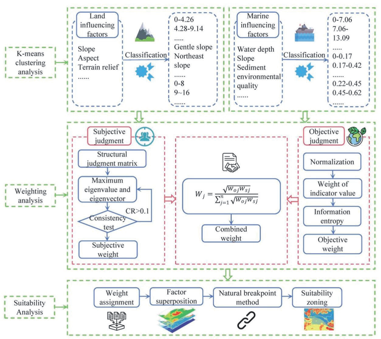
There are significant differences in the geological environmental conditions between land and sea areas, making it difficult to establish a unified set of influencing factors. However, a unified evaluation method can be established (Fig. 2). In this study, different influencing factors were selected for land and sea areas, and K-means clustering, the analytic hierarchy process, the entropy weight method, and the natural breakpoint method were used for analysis. Finally, the fitting relationships between the land and sea areas were evaluated.
K-means clustering is an unsupervised learning method that uses Euclidean distance to measure similarity between data objects. It iteratively updates to obtain the final cluster centers, grouping similar samples into the same subset and minimizing the differences between elements within the same subgroup while maximizing the differences between different subsets [21, 22].
The AHP decomposes the problem into different influencing factors based on the task goal. A judgment matrix is established according to the relationships between influencing factors and subordinate evaluation factors, forming a multilevel analysis structure model. The relevant experts are invited to score, and the weights of each evaluation factor are calculated [23, 24]. The weights are calculated based on human decision-making and may have subjective bias; hence, they are called subjective weights.
The entropy weight method relies on the relationships between evaluation factors to construct a judgment matrix. It then normalizes the data, calculates the ratios and information entropy of each indicator, and finally computes the weights of each evaluation factor. This method is known as objective weight calculation [25, 26].
In this study, the K-means clustering method is first used to cluster the influencing factors into evaluation factors. Then, according to the principles of the AHP, a judgment matrix is established. Experts in the geological environment, marine geology, and engineering geology are invited to score the factors, and subjective weights are calculated. Based on the relationships between the data, a judgment matrix using the entropy weight method is constructed to calculate objective weights.
However, the AHP is a decision-making analysis method that simulates human brain decision-making. It has limited quantitative data and more qualitative components and is subject to strong subjective consciousness. It often overlooks the relationships between data, leading to deviations from the actual situation. The entropy weight method ignores the importance of the evaluation factors themselves, and sometimes the determined objective weights differ greatly from the expected results, making it challenging to meet the target requirements. To avoid the shortcomings of purely subjective weights and purely objective weights, this study uses the formula (1) to optimize and fit the results of the two types of weights, forming an evaluation method that is more in line with reality [27].
Wj is the combined weight, Woj is the objective weight, and Wsj is the subjective weight.
Classification of Influencing Factors
Classification of the Slope Gradient
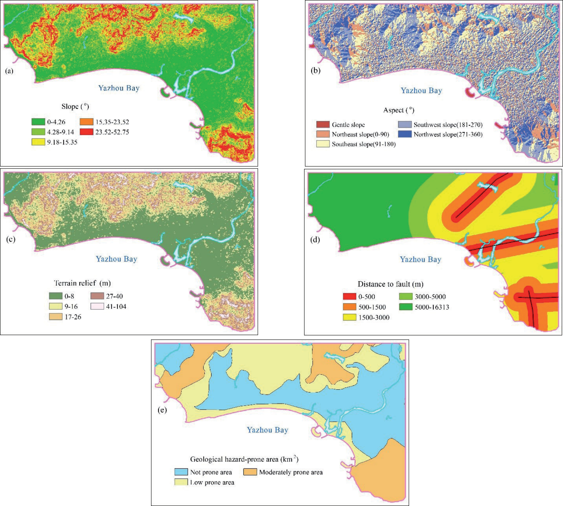
The slope classification was conducted using K-means clustering, resulting in 5 categories. Slopes ranging from 0 to 4.26° are mainly distributed in the surrounding basin of the Ningyuan River and near the Yazhou Bay coastline, which has the largest distribution area. These areas are characterized by loose rock layers consisting of Quaternary Holocene and Pleistocene gravel, sand, clay, and other sediments. Slopes ranging from 4.28 to 9.14° are more scattered and exhibit a point-like distribution. The slopes in the ranges of 9.18 to 15.35°, 15.35 to 23.52°, and 23.52 to 52.75° gradually increase, but the distribution area decreases. They are distributed in a stepwise manner along the Niutou Ridge, Qing Ridge, Nanding Ridge, and Nanshan Ridge in the terrestrial study area, with higher slopes occurring at higher elevations (Fig. 3a).
Classification of Slope Aspect
Based on the location, sunlight, and climate of the study area, the slope aspect is divided into five levels: flat slope, northeast slope (0-90°), southeast slope (91-180°), southwest slope (181-270°), and northwest slope (271-360°) (Fig. 3b). Flat slopes are mainly distributed in the reclaimed areas, while the slope aspect in mountainous areas is more pronounced. In the plain areas, the slope aspect appears as scattered patches without distinct features. Considering the regional characteristics, priority should be given to flat slopes and southeast slopes, followed by southwest slopes, northeast slopes, and finally northwest slopes.
Classification of Terrain Relief
The terrain relief was classified into five categories using K-means clustering: 0-8 m, 9-16 m, 17-26 m, 27-40 m, and 41-104 m. The terrain relief of 0-8 m is mainly distributed in the Ningyuan River basin and the plain area near the Yazhou Bay coastline. The terrain relief gradually increases from 9 to 104 m, transitioning from plains to hills, which are mainly concentrated in the Niutou Ridge, Qing Ridge, Nanding Ridge, and Nanshan Ridge regions. As the terrain relief value increases, the area it occupies gradually decreases (Fig. 3c).
Classification of Distance to Fault
In general, the greater the distance from the fault, the greater the stability of the geological structure. In this study, a distance-increasing method was used to divide the distance from the fault into five levels: 0-500 m, 500-1500 m, 1500-3000 m, 3000-5000 m, and 5000-16313 m (Fig. 3d). The areas with good geological structural stability are located in the western part of the terrestrial research area, while the eastern part is characterized by the presence of three structural belts: the Jiusuo-Nanhao Structure Zone, the Yacheng-Wanning Fault Zone, and the Malin Fault. These belts exhibit relatively poorer stability.
Classification of Geological Hazard-Prone Areas
The study area is divided into three zones based on susceptibility to terrestrial geological hazards: not susceptible, low susceptibility, and moderate susceptibility zones. The respective areas of these zones are 109.92 km2, 82.20 km2, and 57.38 km2 (Fig. 3e), accounting for 44.06%, 32.94%, and 23%, respectively, of the total area. The nonsusceptible zone is mainly distributed around the Ningyuan River basin and its western side. The low-susceptibility zone is located along the Yazhou Bay coastline and the central-northern side. The moderate susceptibility zone is mainly distributed from the Nanshan Ridge to the Qing Ridge and Nanding Ridge.
Classification of Water Depth
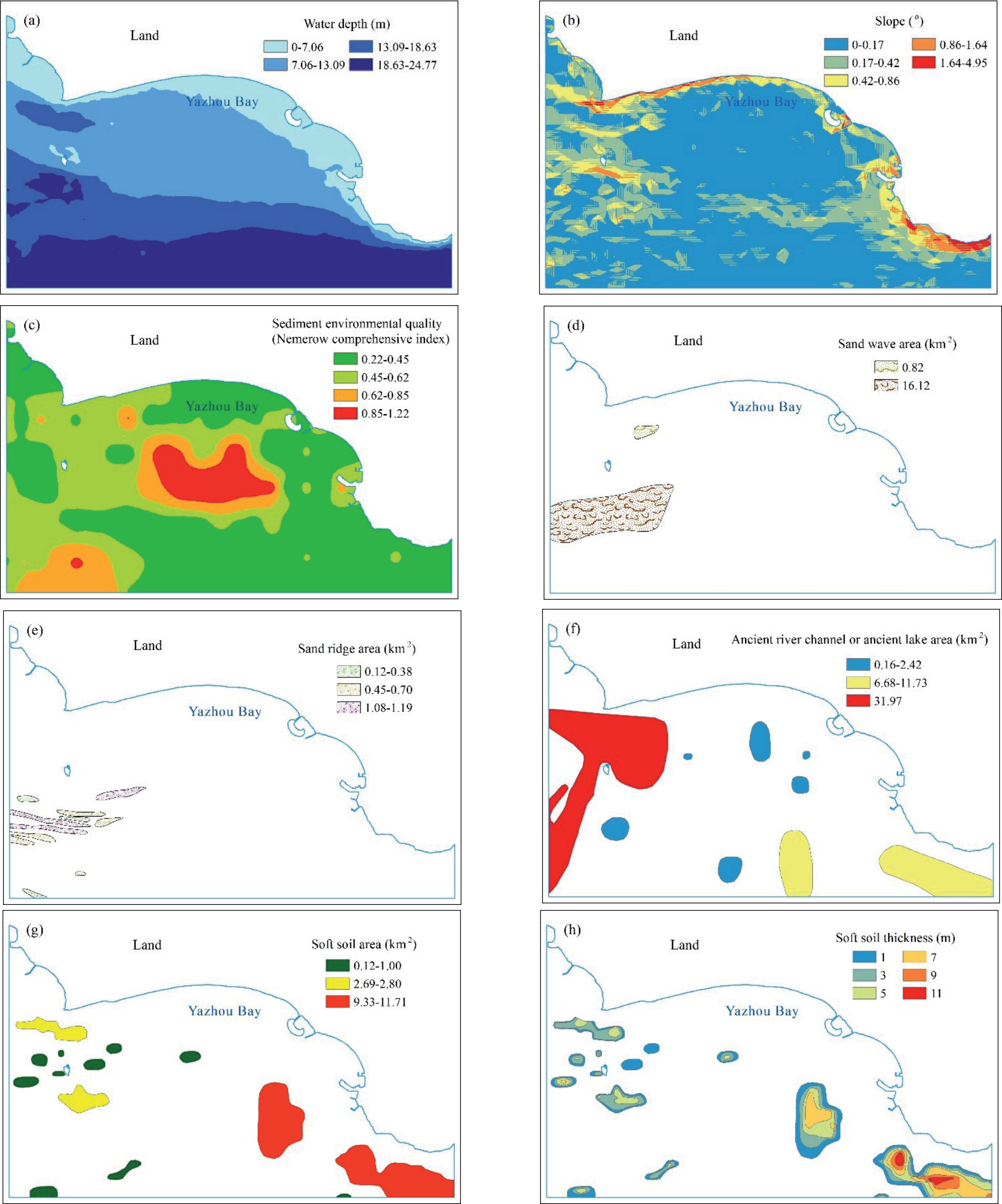
The water depth was classified into four levels using K-means clustering: 0-7.06 m, 7.06-13.09 m, 13.09-18.63 m, and 18.63-24.77 m (Fig. 4a). The depth distribution appeared to be elongated from east to west, with increasing depths from south to north.
Classification of the Slope Gradient
The study area’s seabed slope is divided into five levels, with an overall gentle slope. Slopes ranging from 1.64° to 4.95° and 0.86° to 1.64° are mainly found in the southern mountain corner and the Jiaotou Peninsula, covering a small area. The remaining slopes, ranging from 0° to 0.86°, are distributed in most of the study area’s seabed (Fig. 4b).
Classification of Sediment Environmental Quality
The sediment environmental quality in the study area is classified into five levels. The largest area with a comprehensive Nemerow index ranging from 0.22 to 0.45 was located in the southeastern part of the study area, indicating the best sediment environmental quality in that region. The next level, ranging from 0.45 to 0.62, is mainly distributed in the west. The range of 0.62 to 0.85 is mainly found in the southwest and central parts. The range of 0.85 to 1.22 is only distributed in the central part, forming an elliptical shape, indicating relatively poor sediment environmental quality (Fig. 4c).
Classification of the Sand Wave Area
The study area consists of two sandbars of significantly different sizes, measuring 0.82 km2 and 16.12 km2 (Fig. 4d). Therefore, the sandbars are classified into two levels, located on the north and south sides of Dongluo Island.
Classification of the Sand Ridge Area
The sand ridges in the study area are divided into three levels, with areas ranging from 0.12-0.38 km2, 0.45-0.70 km2, and 1.08-1.19 km2 (Fig. 4e). The majority of the distribution area overlaps with sand waves.
Classification of Ancient River Channels or Ancient Lake Areas
The distribution areas of ancient river channels or ancient lakes can be classified into three levels. Level 1 includes six scattered elliptical areas with a total area of 0.16-2.42 km2, which are located in the middle of the study area. Level 2 consists of elongated areas with a distribution on the southeast, ranging from 6.68-11.73 km2. Level 3 represents the largest area, with a size of 30.97 km2, forming a T-shaped distribution on the west side (Fig. 4f).
Classification of Soft Soil
To measure the impact of soft soil, the three levels of the area were classified as follows: 0.12-1.00 km2, 2.69-2.80 km2, and 9.33-11.71 km2 (Fig. 4g). The thickness was categorized into six levels: 1 m, 3 m, 5 m, 7 m, 9 m, and 11 m (Fig. 4h).
Determining the Weighting Factors for the Evaluation Factors
The same approach is used for both land and marine areas. The selected influencing factors are subdivided into evaluation factors, and pairwise comparison matrices are constructed. The subjective weights and objective weights of the evaluation factors are calculated using the analytic hierarchy process and entropy weight method, respectively. The combined weights of each evaluation factor are then calculated using formula (1) (Table 1).
Table 1.
Table of Weights for Various Influencing Factors.
Evaluation Results
Using the raster calculator in ArcGIS, the evaluation factors were overlaid and then classified into five categories using the natural breaks method. These categories are excellent suitability, good suitability, moderate suitability, poor suitability, and very poor suitability. (Fig. 5). Overall, the central part of the study area has excellent suitability, gradually decreasing towards the periphery. The northwest and southeast regions have very poor suitability, while the coastal areas of Yazhou Bay have good suitability. The land areas with excellent suitability had the largest distribution, followed by those with moderate suitability for marine areas. The largest distribution of moderate suitability was observed when considering land and sea areas together, while the areas with very poor suitability had the smallest distribution (Fig. 6).
The area with excellent suitability covers an area of 140.27 km2, accounting for 27.20% of the study area, and is mainly distributed in the central and northeastern parts of the study area. The land blocks have slopes ranging from 0 to 13.57° and mainly consist of flat slopes, including marine plains and alluvial marine plains. The terrain has a small relief of less than 8 m and is generally located in areas less prone to geological hazards. The area is traversed by the Yacheng-Wanning fault zone and mainly consists of Quaternary deposits such as gravel, sand, and clay. The marine blocks have water depths ranging from 0 to 7 m and slopes ranging from 0 to 5°. There are no adverse geological environmental factors, such as pollution, sand waves, sand ridges, soft soil, ancient river channels, or ancient lakes. The sediment mainly consists of sandy silt and silty sand. The geological environment in this area is favorable, with gentle terrain and shallow water depths, making site selection a priority for construction and development planning.
Fig. 5.
Suitability zoning map for the construction of the Yazhou Bay project in Sanya based on land-sea coordination.
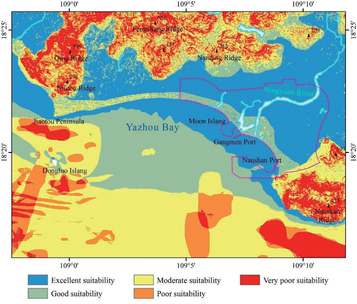
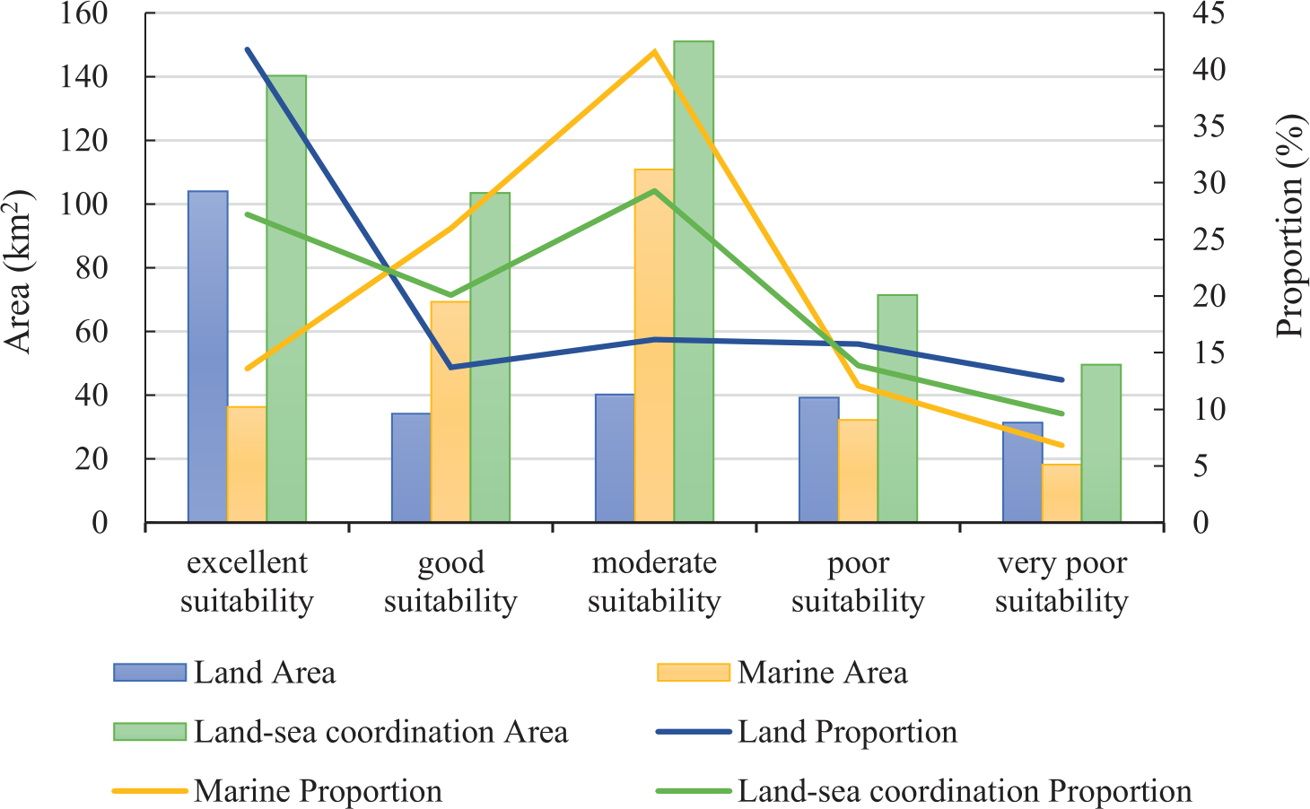
The area with good suitability covers 103.47 km2, accounting for 20.06% of the study area. It is mainly distributed in the central and beach areas of the study area, forming a long strip from east to west. The land blocks have slopes ranging from 0 to 20° and terrain undulations ranging from 0 to 35 m. They are located in a low susceptibility zone for geological hazards, with the Yacheng-Wanning fault zone and Jiusuo-Nan’ao tectonic zone passing through. The main deposits are Quaternary gravel, sand, clay, and Early Jurassic orthogranite. The sea blocks have water depths ranging from 6 to 13 m and slopes ranging from 0 to 3.4°. There is no distribution of soft soil and sand ridges, only local development of sand waves and ancient river channels or lakes. There is mild pollution, with deposits mainly consisting of sandy silt and gravelly silty sand. The geological environment in this area is generally good, with only localized unfavorable geological factors. It is slightly less suitable than areas with excellent suitability and can be considered an alternative area.
The area with moderate suitability covers 151.04 km2, accounting for 29.28% of the study area. It is distributed in a long strip in the southern part and a ring shape in the northern part of the study area. The land blocks have slopes ranging from 0.3 to 31.3°, with a topographic relief of 1 to 40 m. Low and medium susceptibility zones for geological hazards are distributed in the area, with the presence of the Malin fault and the Jiusuo-Nanhao tectonic zone. The main rock formations are Lower Cretaceous rhyolite, andesite, and Jurassic orthogranite and adamellite. The marine blocks have water depths ranging from 7 to 24 m, with slopes ranging from 0 to 3.2°. They consist of thin layers of soft soil, sand waves, sand ridges, and ancient river channels or lakes. There is mild pollution, with sediment mainly composed of sandy silt, silt, and gravelly silty sand. The geological environment in this area is poor, with an increasing number of adverse geological factors that can affect construction. This zone is considered a transitional zone between different subregions, and it is not recommended to plan and construct projects here. If development is necessary, disaster prevention and mitigation measures should be implemented.
The area with poor suitability covers 71.43 km2, accounting for 13.85% of the study area, and is mainly distributed on the east and west sides of the study area. The land blocks have slopes ranging from 0.3 to 39.3° and terrain undulations ranging from 5 to 57 m. They are mainly distributed in areas with low and moderate geological hazard susceptibility, with the presence of the Malin Fault and the Jiusuo-NanHao tectonic zone. The main rock formations are Lower Cretaceous rhyolite, andesite, and Early Cretaceous granodiorite. The sea blocks have water depths ranging from 7 to 25 m and slopes ranging from 0 to 2.3°. The developed soft soil has a thickness of 7 m, and sand waves, sand ridges, and ancient river channels or lakes are present. The main sediment types are sandy silt and gravelly silty sand. The geological environment in this area is poor, with various adverse geological factors affecting construction. The area with moderate suitability increased in both area and thickness. Geological hazards are more developed, and it is not recommended to carry out development activities here.
The area with very poor suitability covers 49.56 km2, accounting for 9.61% of the study area, and is mainly distributed on both sides of the study area. The land blocks have slopes ranging from 9 to 52° and terrain undulations ranging from 17 to 104 m. They are mainly distributed in areas with low and moderate susceptibility to geological hazards, with the presence of the Malin Fault and the Jiusuo-NanHao tectonic zone. The main geological formations are Lower Cretaceous rhyolite, andesite, and Early Jurassic orthogranite. The marine blocks have water depths ranging from 13 to 24 m and slopes ranging from 0 to 1.4°. They are characterized by thick layers of soft soil up to 11 m, as well as the presence of sand waves, sand ridges, and ancient river channels or lakes. The sediment mainly consists of sandy silt and gravelly silty sand. This area has the worst geological environment and is the most prone to geological hazards. Therefore, it is not suitable for development activities.
Discussion
The factors that affect engineering construction on land and in the sea differ significantly. Therefore, this study selected slope, aspect, terrain relief, distance to fault, and geological hazard-prone areas as influencing factors for land, and water depth, slope, sediment environmental quality, sand waves, sand ridges, ancient river channels or ancient lake area, soft soil area, and soft soil thickness as influencing factors for the sea. The selected influencing factors were analyzed using the same method. The results showed that the suitability zones of land and sea can essentially be connected, indicating that although different influencing factors are chosen for land and sea due to geological environmental differences, a unified evaluation system can be established to divide the land-sea integrated functional zones. This model overcomes the traditional separation of land and sea and can serve as a reference for integrated land-sea planning.
The selection of the evaluation scope plays an important role in calculating objective weights. First, the influencing factors within the evaluation scope are selected. Then, a grading system is applied, followed by calculating numerical values between different influencing factors. The size of the evaluation scope greatly affects the grading of influencing factors and the calculation of numerical values. For example, slope grading is based on the numerical values of slopes within the evaluation scope for clustering and division. The numerical values of various influencing factors, such as slope, aspect, terrain relief, distance to fault, and geological hazard-prone areas, are selected and calculated within the evaluation scope. Additionally, the division of suitability is also based on the relative differences within the evaluation scope. Therefore, the land use range should be selected as the evaluation scope. If there is no land use range, a range with minimal geological environmental differences should be selected step by step until the optimal area is determined.
Yazhou Bay Science and Technology City, Moon Island, Gangmen Port, and Nanshan Port are primarily located in areas with good to excellent suitability (Fig. 5), indicating that the location selection of the study area construction project is reasonable. After four years of development, Yazhou Bay Science and Technology City has already achieved a certain scale. This also validates the accuracy and guiding significance of our evaluation model. In the next step, Yazhou Bay Science and Technology City can expand towards the west and the nearby areas with excellent and good suitability.
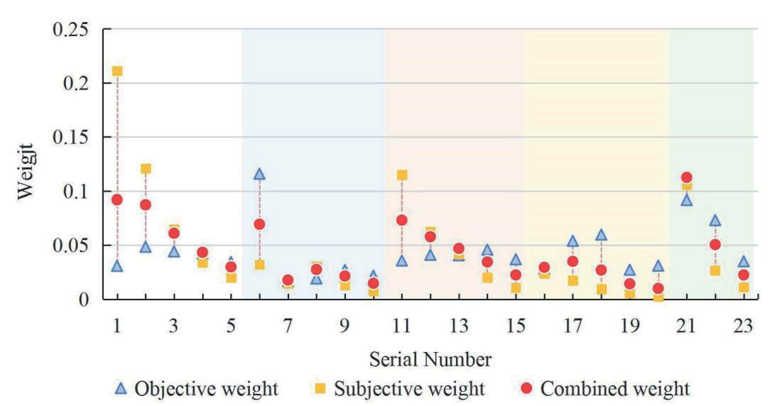
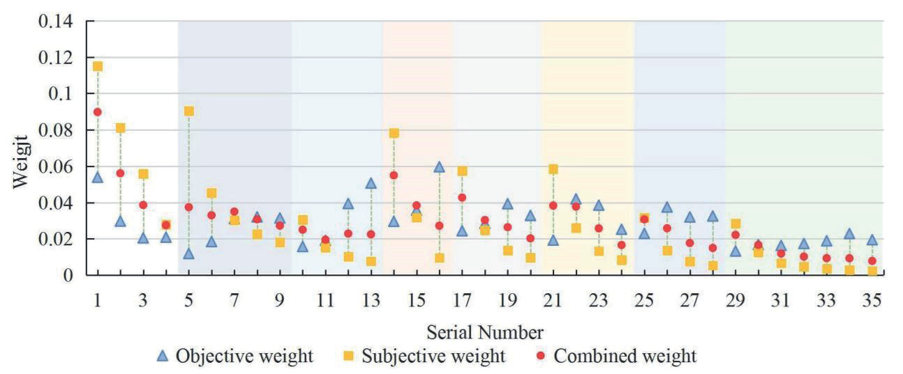
Among the land evaluation factors, the subjective and objective weights differ the most for slopes ranging from 0 to 4.2599°, while the subjective and objective weights are closest for terrain undulations ranging from 17 to 26 m. There are 8 cases where the subjective weight is greater than the objective weight, accounting for 34.78% of the total, and 15 cases where the subjective weight is smaller, accounting for 65.22%. The subjective and objective weights for the evaluation factor of the distance to a fault are relatively close, while the combination weights for the evaluation factor of geological hazard-prone areas differ the most (Fig. 7). Among the marine evaluation factors, the subjective and objective weights differ the most for slopes ranging from 0 to 0.1731°, while the subjective and objective weights are closest for slopes ranging from 0.4195 to 0.8579°. There are 12 cases where the subjective weight is greater than the objective weight, accounting for 34.29% of the total, and 23 cases where the subjective weight is smaller, accounting for 65.71%. The subjective and objective weights for the evaluation factor of soft soil thickness are closest (Fig. 8). It can be concluded that the subjective and objective weights differ and do not follow a clear pattern. However, by calculating the combination weights through the fitting, it can be observed that when the subjective and objective weights differ significantly, there is a large discrepancy in their discrimination. In such cases, the combination weight is taken as less than the average of the two weights. Conversely, when the difference is small, the opposite is true, which is more consistent with reality.
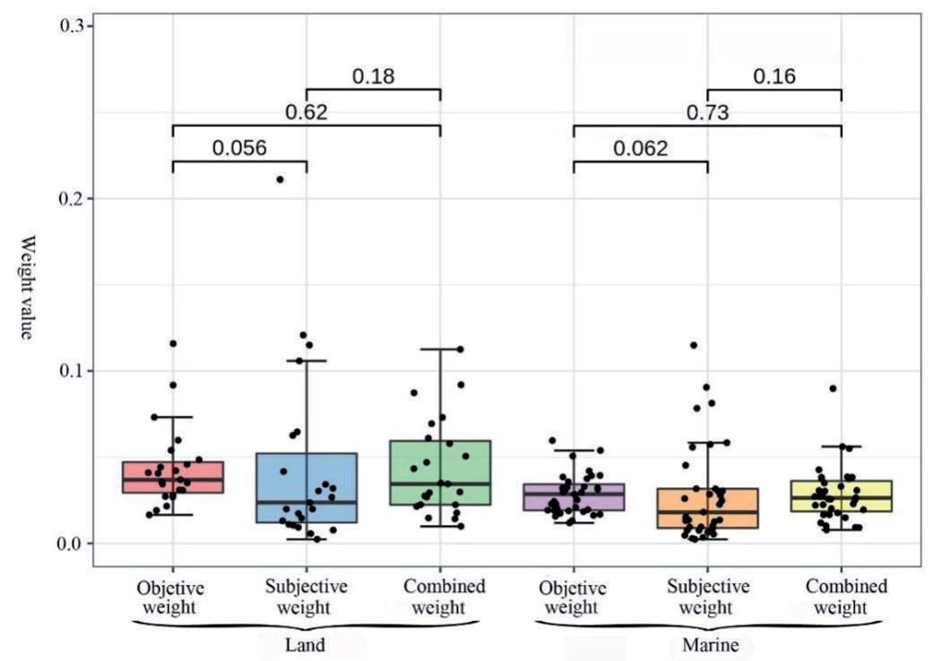
The box plots show that both the objective and subjective weights for land and sea have smaller fluctuations compared to the subjective weights. The median of the objective weights is larger than the median of the subjective weights. Additionally, the range of the combined weights is greater than that of the objective weights but smaller than that of the subjective weights. Using the Wilcoxon signed-rank test, it was found that the objective weights and combined weights for land and sea were the closest (P=0.62-0.73), followed by the subjective weights and combined weights (P=0.16-0.18), and the largest difference was between the objective weights and subjective weights (P=0.056-0.062). This analysis indicates that although the influencing factors for land and sea are different, the weights for both show similar changes when analyzed using the same method, suggesting a certain degree of correlation between the two. The medians of the subjective, objective, and combined weights for land are larger than those for sea. This is because there are more influencing factors for the sea, resulting in smaller weights allocated to each evaluation factor. However, this does not affect the similarity in weight changes between land and sea (Fig. 9).
Conclusions and Recommendations
This study selected five influencing factors for land suitability, including slope, aspect, terrain relief, distance to fault, and geological hazard-prone areas. For sea suitability, eight influencing factors are considered, including water depth, slope, sediment environmental quality, ancient river or lake area, sand wave area, sand ridge area, soft soil area, and soft soil thickness. The factors were then classified, and the subjective and objective weights of the evaluation factors were calculated using the AHP and entropy weight method. By combining the factors, the study divided suitability into five categories: excellent suitability, good suitability, moderate suitability, poor suitability, and very poor suitability. The geological and environmental characteristics of each category were analyzed.
Overall, the central part of the study area has excellent suitability, gradually decreasing towards the periphery. The northwest and southeast regions have very poor suitability, while the coastal areas of Yazhou Bay have good suitability. The land areas with excellent suitability had the largest distribution, followed by those with moderate suitability for marine areas. The largest distribution of moderate suitability was observed when considering land and sea areas together, while the areas with very poor suitability had the smallest distribution.
In this study, the Analytic Hierarchy Process was used to calculate the subjective weights of evaluation factors, while the Entropy Weight Method was used to calculate the objective weights of evaluation factors. The combination of the two methods can effectively avoid the shortcomings of a single model, making it a scientific evaluation method for integrated land and sea spatial planning.
Although there are significant differences in geological and environmental factors between land and sea areas, by selecting different influencing factors and using the same evaluation method, it has been proven that the suitability of land and sea areas can be effectively combined. This demonstrates the rationality and practicality of this analytical method.
There are many factors that influence national territorial spatial planning. In the actual evaluation process, it is necessary to consider factors such as working conditions, marine environment, and development needs, and to fully take into account the existing technological conditions as the basis for selecting appropriate influencing factors for research.
In the suitability zoning map, some subregions are divided too finely, resulting in overlapping and entangled boundaries. This is a normal phenomenon caused by significant differences between adjacent areas when numerical values are superimposed. However, it is difficult to further divide these areas when planning functional zones. Therefore, in practical applications, dimension reduction and fitting should be conducted based on the positioning of the functional zones.

