

Introduction
Algeria has been considered an arid country for the last decades. The country is faced with problems of mobilizable water resources which arise not only in terms of available quantity but also in terms of quality [1-4].
Recently, there have been many studies on the physicochemical analysis of groundwater such as the studies of Abdennour et al. [5], Dimple et al. [6], Athamena et al. [7], and Metaiche et al. [8]. These studies contributed to the development of groundwater quality, making it a dependent tool for monitoring and predicting water quality in the studied regions.
In southern Algeria and particularly in the Ouled Djellal region, In light of the difficult climatic conditions and scarcity of rain, the study of water quality and rational use of groundwater is considered an inevitable result to ensure agricultural development.
To determine the studied region's water quality, samples were taken from the Albian Ouled Djellal aquifer from nine boreholes to carry out the analysis of 19 physico-chemical parameters.
The physico-chemical measurements (temperature, electrical conductivity, and pH) are carried out on-site, while the dosages of chemical elements (Ca2+, Na+, K+, Mg2+, SO4-, Cl-, HCO3- and NO3-) are determined at the level of the laboratory.
Ouled Djellal region is agricultural, so it is necessary to determine the adaptation of water for irrigation, to avoid any danger of some chemical elements may present for plants and soil. This chemical study is based on standards illustrated on a diagram using Sodium adsorption rate, Wilcox diagram, Magnesium absorption ratio, Residual sodium bicarbonate, Permeability index, and Stuyfzand index to evaluate its suitability for irrigation.
This present study focuses on giving an idea about the groundwater characteristics in the Ouled Djellal region and its suitability for water supply and irrigation.
Materials and Methods
Presentation of the Studied Area
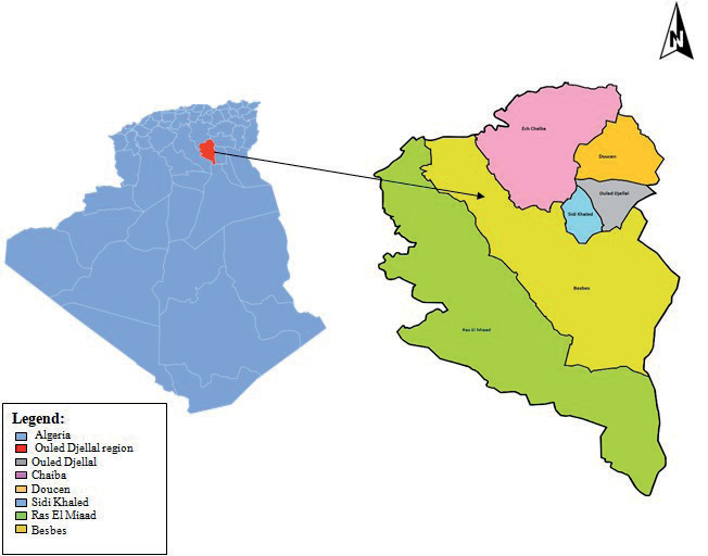
Ouled Djellal is an Algerian “wilaya” and contains six communes created in 2019. It is situated in the Algerian Sahara with the following coordinates: -34°25’ and 32°’ North and 5°03’ and 51°’ East, and has an area of more than 11,000 km2, with an average altitude at around 200 m. The situation of the Ouled Djellal region is presented in Fig. 1.
Table 1.
Water Classification According to Algerian and WHO Standards.
Geology and Hydrogeology of the Region
Ouled Djellal region represents a country of structural and sedimentary transition. In the North, it is a mountainous country, while in the South it is a collapsed country, which is part of the Northern Sahara. The passage between these two distinct domains is made via a set of flexures, folds-faults, and east-west oriented faults called the South Atlas Accident.
In the Saharan platform, the Albian aquifer extends 600,000 km2 in sandstones and clays dating back 100 to 150 million years, around 2000 billion m3 of water are trapped. It occupies the entire northern Algerian Sahara and extends into southern Tunisia and northern Libya. Locally, the flow of water is from west to east. The supply of the Albian aquifer, although minimal, comes directly from rainwater at the foothills of the Saharan atlas [9].
The continental intercalary table, according to the study of variation in the thickness of the formations posterior to the continental intercalary [10].
Measurements and Samples
Samples are taken by the team of Ouled Djellal Water Resources Management laboratory accompanied by the Hydraulic Technical Control service and the Algerian Water Service in 2022, to acquire representative data on spatial variability.
Multivariate statistical techniques and Digram are used in the study by applying XLSTAT and software diagrams [11].
The conformity of the supply water of the region was confirmed using both Algerian and World Health Organization (WHO) standards given in Table 1 [12, 13].
To verify the suitability of Ouled Djellal water for irrigation, its characteristics were calculated and classified using Sodium Adsorption Rate (SAR), Stuyfzand Index, Permeability Index, Residual Sodium Bicarbonate, Magnesium Absorption Ratio, and the Wilcox diagram.
Results and Discussion
Diagram
Piper Diagram
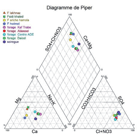
The Piper diagram makes it possible to represent the chemical facies of a set of water samples. This drawn diagram plotted the equivalent proportions of major cations on one triangular diagram [14-17].
Fig. 2. represents the Piper diagram, which determines the chemical analysis of the groundwater.
Analyzed water is characterized by dominant chemical facies (Chloride, sulfate, nitrate calcium, magnesium). Knowing that nitrate is the dominant cation, and chlorides are the dominant onions for all studied samples.
Table 2.
Formula of Indices Values.
Schoeller-Berkaloff Diagram
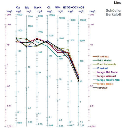
The Schoeller-Berkaloff diagram is a representation of several analyses on the same graph of the different ions in mg/L. If the concentrations are identical, we find a superposition of the straight lines obtained, and otherwise, we notice a relative shift of the latter [18].
Fig. 3. represents the results of the Schoeller-Berkaloff diagram for the 9 boreholes. The found results confirm the predominance of the following facie (Chloride, Sulfate, Calcium, and Magnesium). The results confirm the Piper Diagram results shown in Fig 2.
Water Quality Indices
The suitability of Albian waters of southern Algeria quality was investigated using index calculation which includes Sodium Adsorption Ratio (SAR), Kelly's Ratio (KR), Sodium percentage (Na), Permeability Index (PI), Magnesium Absorption Ratio (MAR), Residual Sodium Bicarbonate (RSBC), Potential Salinity (PS), and Stuyfzand Index [11]. Their formula and calculation are given in Table 2 and Table 3, respectively.
The analysis of salinity using the SAR method has given the following classification:
Group 1: this class represents water from boreholes (Lakhnez, Sidi Khaled, Ariche Hamola, and Hwimel). This water is suitable for plants that have a slight tolerance to salt;
Group 2: boreholes belong to (Alàassel, Center ADE, and Souireg). which are distributed at medium risk of salinization, and can only be used for plants tolerant to salinity and for aerated (coarse texture) and permeable soils.
Group 3: boreholes (Kaf Trabe and Daicel) which are distributed at high risk of alkalization, can only be used for plants very tolerant to salinity and for well-drained soils and better with the addition of organic matter.
SAR classification has demonstrated a low, medium to high risk of groundwater-related salinization but can be used with salinization control.
The Wilcox classification is based on electrical conductivity and sodium content in water [19]. The analysis of the results shows that Ouled Djellal waters have poor quality.
MAR is studied to determine the ratio of magnesium in the soils. MAR results have shown that borehole water represents less than 49%, so this water can be used for irrigation but with caution.
As bicarbonate and carbonate concentrations affect the suitability of water for irrigation. [20]. RSBC results show a variation of less than 10 meq/L of RSBC for all the water from the 3 boreholes, which indicates a marginal groundwater quality that does not pose a problem of bicarbonate and calcium on the irrigated soil and 6 boreholes more than 10 meq/L of RSBC, which indicates unsatisfactory groundwater quality.
Water quality permeability has a strong relation with the presence and the absence of several kinds of seals [20, 21]. PI results have demonstrated two kinds of boreholes:
The first has PI between 25% and 75% (Daicel, Kaf Trabe, Alàassel, Center ADE, Ariche Hamola, Souireg boreholes) which indicates that there is no problem with soil permeability.
The second has PI lower than 25% (Lakhnaz, Sidi Khaled, and Hwimel boreholes) which indicates a major problem of soil permeability because of the high concentrations of salinity elements (Na+, Ca2+, and Mg2+) which increase depending on the agricultural activity of soil [22].
Table 3.
Agricultural Suitability Index for Ouled Djellal Albian water.
SI is a parameter that has a wide relation with chloride concentration and electrical and sodium conductivity [23]. SI results have shown that all the boreholes have SI between 300 and 1000 mg/L, which means that are characterized by Saumater water.
Conclusions
The present paper aims to understand the mechanisms that control hydrochemistry and evaluate the suitability of Albian water in the Ouled Djellal region for water supply and irrigation using multivariate statistical analysis techniques (PCA and CAH) and the diagram (Piper, Schoeller-Berkaloff, SAR, Wilcox) and indices (MAR, RSBC, PI, and SI).
The interpretation of these parameters allowed us to note that the boreholes in this region are not used for irrigation, which is characterized by a high salinity content which influences the permeability of the soils to be irrigated. The majority of boreholes present poor quality water that is not acceptable for water supply and the parameters tested are not within the standards, the concentration of the majority of the characteristics is high. The water quality of boreholes is influenced by the local geology of the region. To use this water, its treatment is required.

