Introduction
Mangrove forests represent highly productive tidal saline wetland ecosystems that thrive along sheltered tropical and subtropical coastlines [1, 2]. Among these ecosystems, the semi-mangrove species, Heritiera littoralis, a member of the Sterculiaceae family, stands out as a distinctive amphibious species. Typically situated along the inner margins of mangrove ecosystems, H. littoralis is adapted to withstand flooding primarily during spring tides or super tides [3- 6]. Beyond its ecological significance in terms of wave attenuation and shoreline protection [7, 8], H. littoralis boasts notable medicinal and culinary attributes. Its leaves, for instance, have been utilized for treating conditions like hematuria, burns, and gum bleeding [9- 12]. Further contributing to its value, the ketones found in its leaves have demonstrated anti-cancer properties, and its seeds can be processed into oil, offering diverse applications [13, 14].
H. littoralis is a vulnerable species in the “China Red List of Biodiversity-Volume of Higher Plants” [15]. In China, this species is primarily distributed in Guangdong, Guangxi, Hainan, and Taiwan [16, 17]. Based on statistics, in 2004, the full distribution area of H. littoralis in China was below 30 hm2, with over 20 mature wild individuals distributed in Yanzao, Haifeng Xiangkeng, Fangchenggang, and Qinglan Port, Hainan [16]. By 2013, while the distribution area and number of H. littoralis individuals had increased slightly, the overall size still occupied less than 30 hm2, with fewer than 500 mature individuals [18]. Additionally, global climate change may result in the expansion and contraction of distribution areas, changes, habitat loss, and fragmentation of most species, as well as the extinction of endangered species with limited natural distribution ranges [19-23]. Therefore, it is necessary to find suitable habitats, thus expanding the cultivation area and improving the quality and yield of the H. littoralis industry.
The Maximum entropy model (MaxEnt) was initially derived from information science, and was first proposed by Jaynes in 1957 [24]. Subsequently, it has been widely adopted and is popular in several fields, including information classification, language processing, and species geographical distribution [25-28]. Based on the maximum entropy theory, the MaxEnt software is able to estimate the distribution (geographic range) of a species by determining the distribution (locations where the species has been found) carrying the maximum entropy subject to constraints derived from environmental conditions at recorded occurrence locations [29-31]. Compared to other models, MaxEnt has been widely adopted due to its optimal performance with small sample sizes relative to other modeling methods [32, 33].
The spatial distribution of plants is intimately linked to environmental conditions, and climate is a critical factor in determining the geographical distribution of plants on a regional scale [34, 35]. With the expanded planting of traditional Chinese medicine, it is especially crucial to provide scientific guidance for its introduction and cultivation to limit losses resulting from blind introduction. To date, research on H. littoralis has focused on breeding ecology, medicinal ingredients, and genetic diversity, while research on its ecological suitability has scarcely been reported [36].
To address the above concerns, in this study, we used MaxEnt modeling to project past, present, and future distribution patterns of H. littoralis in China, as well as identify the critical, decisive environmental factors impacting the potential regions. Collectively, the aims of this study are: (1) to reveal the current and future distribution patterns of H. littoralis in China; (2) to outline the changing trends of potential regions under future climate change scenarios; and (3) to determine the key environmental factors and their ranges for determining potential distributions.
Experimental Methods
Sample Distribution Data Source and Pretreatment
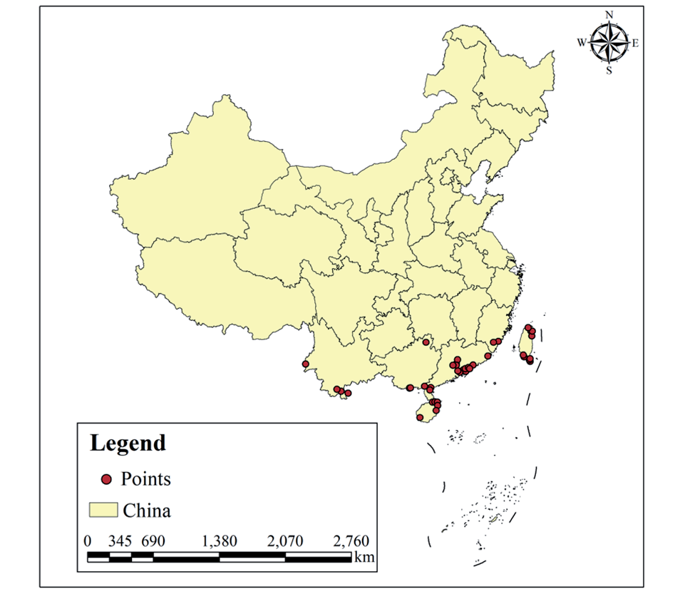
Information on the distribution of the H. littoralis was collected through searches of the China Digital Herbarium (CVH, https://www.cvh.ac.cn/), Global Biodiversity Information Facility (GBIF, https://www. gbif.org/), and Plant Photo Bank of China (PPBC; http://ppbc.iplant.cn/). A total of 156 occurrence points in China were acquired. The sites lacking latitude and longitude information, duplicate records, or obvious errors were discarded, and a buffer analysis method was used to select and proofread the distribution data. In total, 41 distribution site records across China were obtained for model construction (Table S1).
Climate Data Source and Pretreatment
Environmental data were obtained from the WorldClim data website, including the Last Glaciation Maximum (LGM), the present day, and the future periods. The current environmental data included 19 environmental variables from 1970 to 2000. Future environmental data encompassed 19 environmental variables from the 2050s (2041-2060) and 2070s (2061-2080) under the RCP4.5 climate scenarios. Climate scenarios RCP2.6, RCP4.5, RCP6.0, and RCP8.0 correspond to temperature increases of 1ºC, 1.5ºC, 2ºC, and 4ºC, respectively. We selected RCP 4.5 in our scenario explorations because the Paris Agreement proposed a temperature control target of 1.5ºC instead of 2ºC in 2018, which has clear benefits for humans and natural ecosystems and helps promote equitable and sustainable development of human society. The above data was spatially resolved at 2.5 arc-minutes, in tiff format raster files, using the administrative map of China as the base map for extraction of climate variables. To avoid the multicollinearity of variables resulting in model overfitting, the Pearson correlation coefficient was employed for the selection of environmental variables [37-39]. We used the Pearson correlations to examine the cross-correlation (SPSS v20.0). Only variables possessing weak correlations (|r| <0.9) were utilized in further analyses, one with lesser environmental significance was discarded. Based on the above conditions [40], 12 environmental variables (Table 1) were selected for the prediction of the suitable habitats of H. littoralis.
Table 1.
Twelve climate factor variables used in the MaxEnt model.
Maxent Modeling and Parameter Setting
MaxEnt (v 3.4.1) was utilized to determine habitat suitability and potential geographical distribution of field H. littoralis under the LGM, present, and future climate scenarios by combining precise climate variables with presence-only data [31]. We selected a cutoff to calculate the importance of the variable: 75% of the location data for model training, and the remaining 25% was used to validate the model, 1000 maximum iterations, and 10 replicates under subsample run types while maintaining other characteristics as defaults [31].
MaxEnt automatically drew ROC Curves (Receiver Operating Characteristic Curve) and calculated Areas under curves (AUC) to evaluate the accuracy of model prediction results. The value range of AUC was [0,1]. Model performance was classified as failing (0.5-0.6), poor (0.6-0.7), fair (0.7-0.8), good (0.8-0.9), or excellent (0.9-1.0) [31], in which AUC values closer to 1 indicate better-performing models. The Jackknife method was employed to analyse the contribution level of each climate factor to the model for the prediction, and the primary climate factors affecting the distribution of H. littoralis were found.
Division of Suitable Area
The prediction result generated by MaxEnt software was a grid layer in asc format. The output results in ASCII format were then imported into ArcGIS10.1 for suitability classification and visual representation. The default fitness index range was 0 to 1. The value of the grid represented the survival probability (P) of H. littoralis in a given distribution area. These values were reclassified based on the natural discontinuous breakpoint classification method, and the comprehensive probability of suitable distribution regions was separated into four classes: (i) unsuitable (P<0.1); (ii) low suitability (0.1≤P<0.3); (iii) medium suitability (0.3≤P<0.5); and (iv) high suitability (P≥0.5) [41]. Ultimately, the potential distribution regions of each class were extracted for further analysis. The forecast results were analysed and visualised using ArcGIS software, and the distribution pattern of potentially suitable habitats for H. littoralis in China was drawn.
Results and Discussion
Model Prediction Accuracy
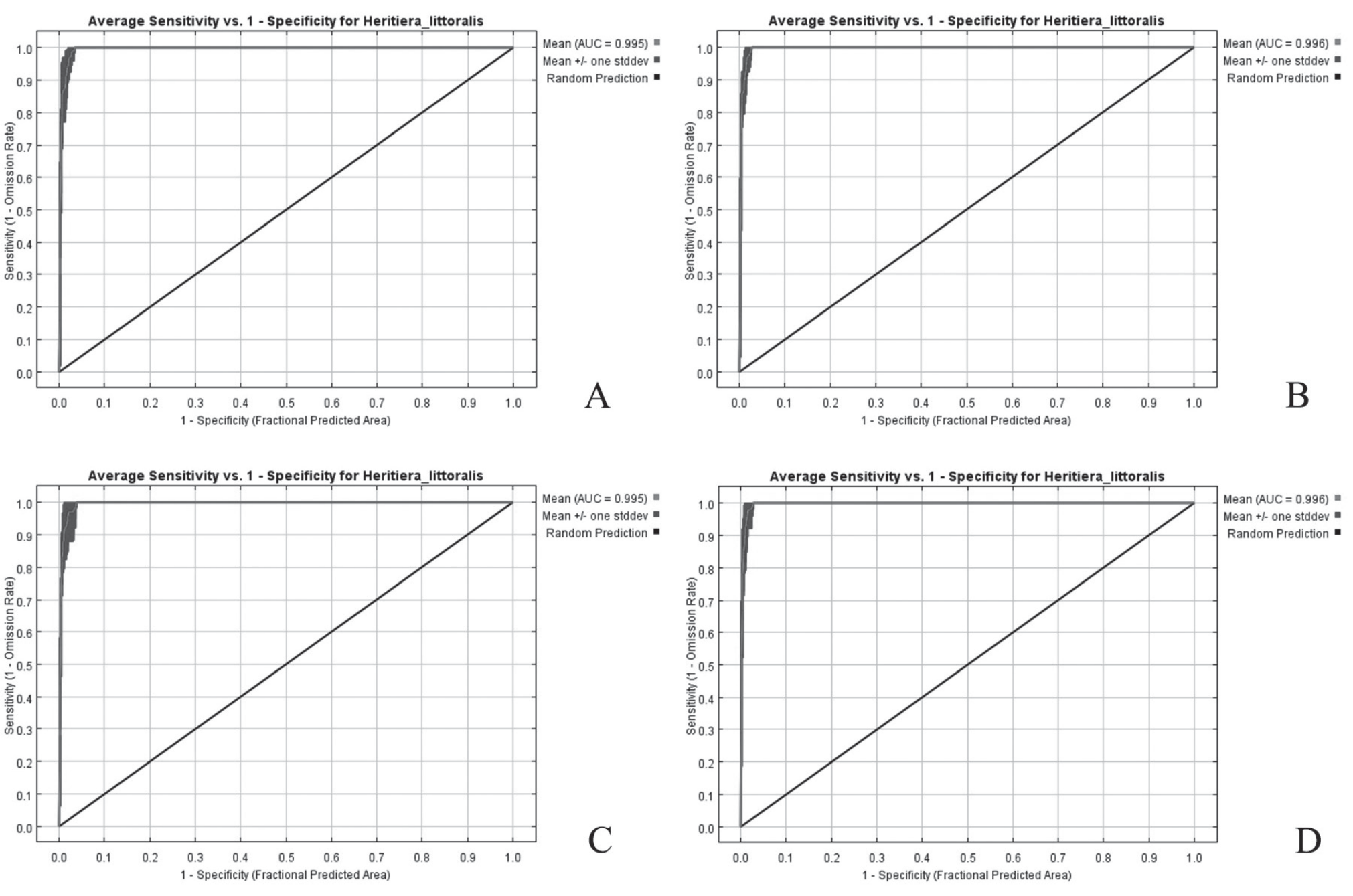
In this study, the AUC (the area under the ROC curve) values were utilized to validate habitat distribution models. The average AUC values under LGtM, present, 2050 (RCP4.5), and 2070 (RCP4.5), respectively, were obtained. Additionally, the average AUC values for models under each climate condition were determined. The results indicated that all these models had high AUC values ranging from 0.995 to 0.996 for the habitat distribution under current conditions (Fig. 1). Collectively, the above results exhibited that the results of MaxEnt modeling for habitat distribution were accurate and reliable for use in further analysis.
Primary Environmental Factors Affecting the Distribution Area of H. Littoralis
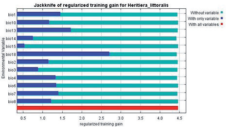
The MaxEnt model’s internal jackknife test related to factor importance indicated that precipitation of warmest quarter (Bio 18, 57% of variation), temperature seasonality (Bio 4, 13.8% of variation), mean diurnal range (Bio 2, 9.7% of variation), precipitation of wettest month (Bio 13, 5.7% of variation), and annual mean temperature (Bio 1, 5.3% of variation) were the most important factors. The cumulative contributions of these factors reached levels as high as 91.5% (Table 2). Across these five environmental variables, three were linked to temperature, and two were associated with precipitation, suggesting that temperature and precipitation were the environmental factors that most impacted the suitability distribution of H. littoralis.
Fig. 1.
ROC curves of H. littoralis data during a) the LGM period, b) the Current period, c) 2050, and d) 2070.
The above five leading environment variables were employed for single-factor modeling, and corresponding single-factor response curves were generated (Fig. 2). When P<0.50, the condition of the environmental variable is very unsuitable for survival, while the environmental variable when P≥0.50 suggests that the range suitable for the survival of the species. According to the response curves, higher probabilities of H. littoralis presence were obtained when the precipitation of the warmest quarter (Bio 18) was above 719 mm. For variables Bio 4 (Temperature seasonality), Bio 2 (Mean diurnal range), Bio 13 (Precipitation of wettest month), and Bio 1 (Annual mean temperature), the optimal habitat suitability is between 3374 and 5595, between 5.2ºC and 7.6ºC, >272 mm, and 20.74 to 24.22ºC, respectively. Outside of these ranges, the suitability of the habitat was reduced (Fig. 2).
The growth distribution of H. littoralis is linked to the environment, and the geographical conditions and climate factors of the habitat are the most important factors in determining the success of the species [23]. The output results of the MaxEnt model in this study suggested that temperature and precipitation had the greatest impact on the distribution of H. littoralis, aligned with the growth of mangroves. Precipitation is one of the main factors governing mangrove distribution. The results of Bio 18 and Bio 13 both demonstrated that when precipitation was low, the growth of H. littoralis increased rapidly. When precipitation reached a certain value, the occurrence probability of H. littoralis began to decrease. Previous research has shown that the water tolerance of H. littoralis is not as robust as that of other mangrove plants [42]. Therefore, appropriate water conditions are more important for the growth of H. littoralis, and it is more suited to growth in the upper portion of the fluctuation zone, which is relatively dry. IN addition, temperature is one of the other primary factors governing mangrove distribution. Our experimental results indicated that the suitable range of annual mean temperature in the distribution area of H. littoralis was 20 to 24ºC, consistent with the current environment.
Table 2.
The contribution levels of 12 climate factors on the distribution rate of H. littoralis
| Climate variables | Contribution rate (%) | Climate variables | Contribution rate (%) |
|---|---|---|---|
| Bio 18 | 57 | Bio 15 | 1.8 |
| Bio 4 | 13.8 | Bio 6 | 1 |
| Bio 2 | 9.7 | Bio 7 | 0.7 |
| Bio 13 | 5.7 | Bio 8 | 0.5 |
| Bio 1 | 5.3 | Bio 3 | 0.2 |
| Bio 14 | 4.1 | Bio 10 | 0.1 |
Fig. 2.
Response curves of primary climate factors a) Bio 18, b) Bio 4, c) Bio 2, d) Bio 13, e) Bio 1.
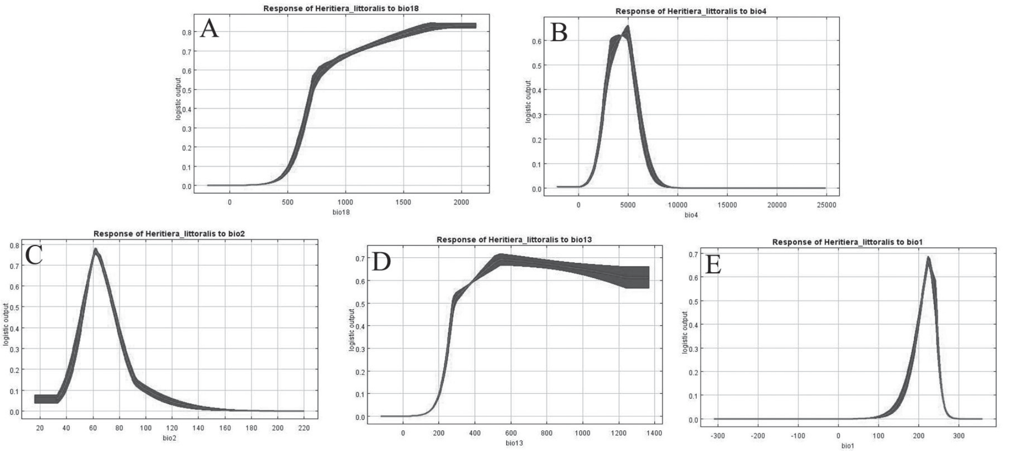
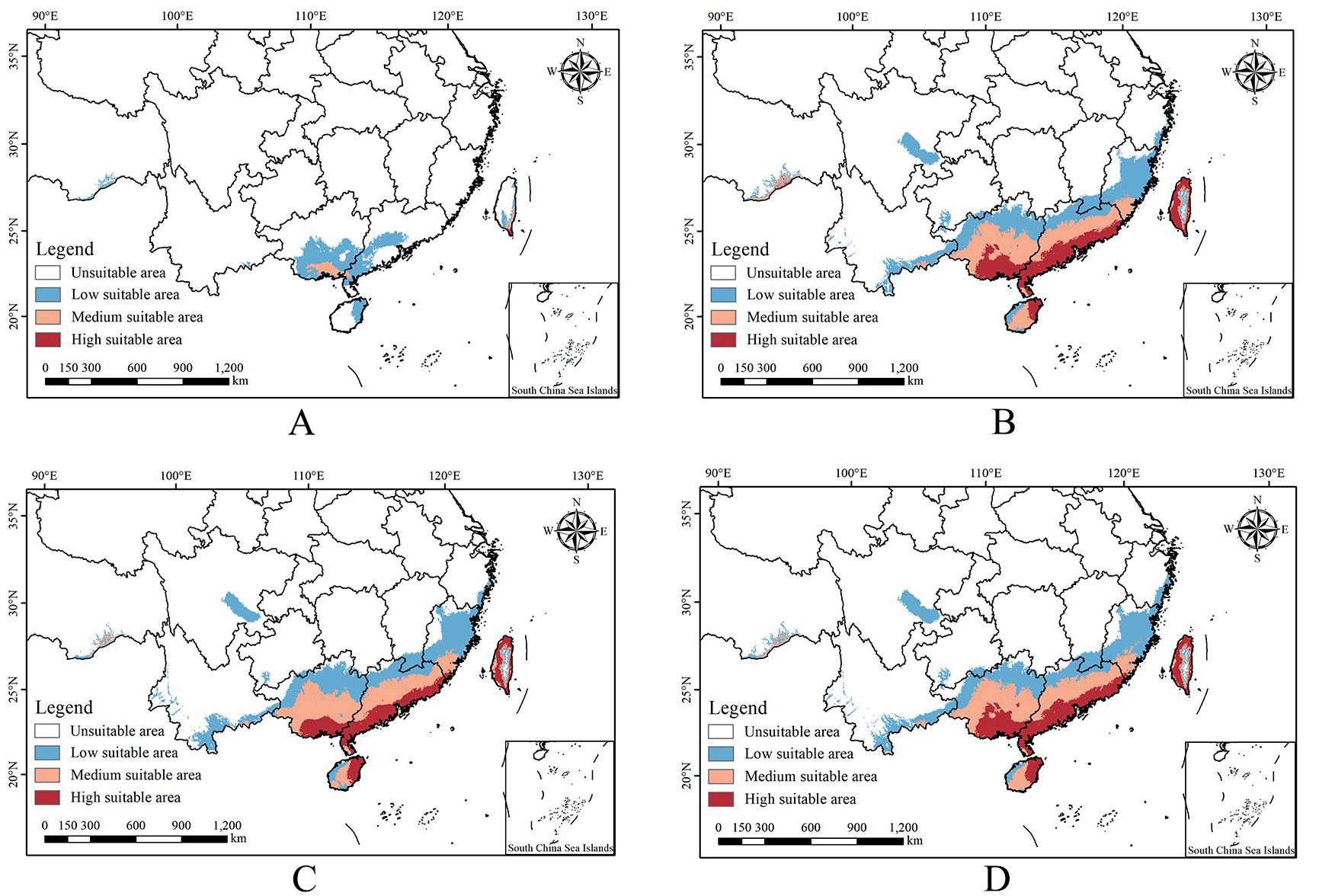
Fig. 3.
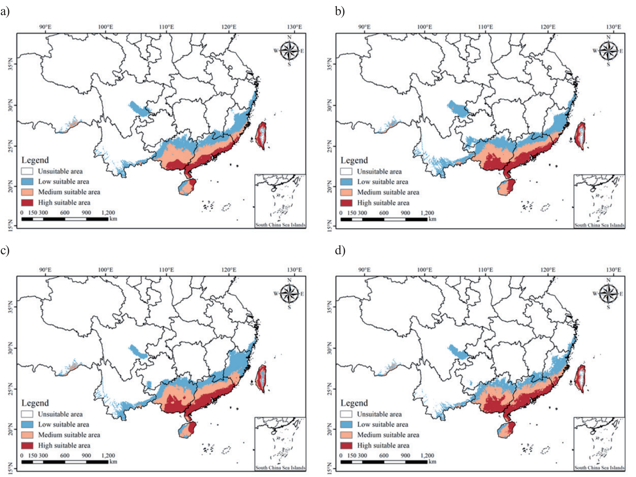
Ecological suitability identification of H. littoralis in China during a) LGM period, b) Current period, c) 2050, and d) 2070.
Ecologically Suitable Areas in China
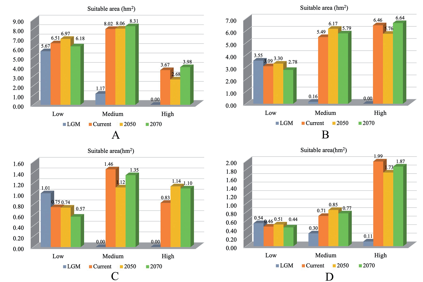
Areas in which the suitability index >0.1 are considered to be the ecological suitability area of H. littoralis. The ecologically suitable areas in China are distributed across Guangxi, Guangdong, Hainan, Taiwan, Fujian, and Zhejiang, accounting for 5.9% of the total area of China. The areas with ecological suitability indexes 0.1-0.3, 0.3-0.5, and 0.5-1 were 25.4 hm2, 17.99 hm2, and 13.21 hm2, respectively. Among them, Guangxi possesses the largest ecological suitability area, with an area of 15.04 hm2 (Fig. 2). The area of high suitability is primarily localized near the sea in Guangxi, Guangdong, Hainan, and Taiwan during the present day. Guangdong has the largest area of high suitability, followed by Guangxi, Taiwan, and Hainan.
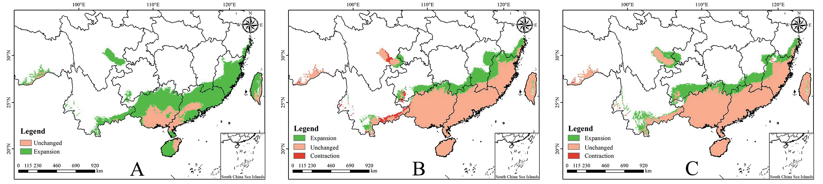
Compared to the current potential distribution pattern, the future distributions (2050 and 2070) indicate that under the influence of future climate warming, the potential distribution area of H. littoralis will be reduced by 2050, and the suitable area will decrease by 0.05 hm2, mainly occurring in southeast Yunnan. By 2070, the suitable areas will be increased, and the total area that is suitable will be increased by 2.18 hm2 (Fig. 4). However, the increase in the area will mainly occur throughout the inner land zone, and the changes in the coastal zone are not clear. Moreover, there are several variations in the distribution of suitable areas across different provinces. In Guangxi, Hainan, and Taiwan, the highly suitable areas will experience a more dramatic increase in 2070. Guangxi Province will experience the most noticeable increase in suitable areas compared to the LGM period (Fig. 5).
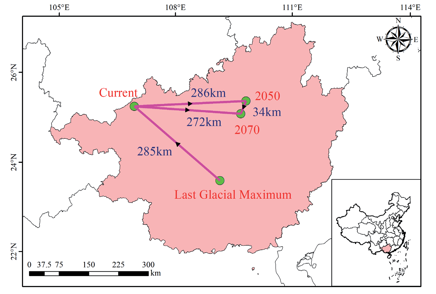
Fig. 6.
Location of the central shift of suitable areas of H. littoralis under RCP4.5 scenario in different periods.
Prior research has indicated that the diversity of the H. littoralis community decreases from the coast of adjacent seas to the marsh of inland seas [43]. Based on the distribution map of H. littoralis we have generated, the suitability index is higher closer to the sea area, which is consistent with the general suitability of mangrove plants. This suggests that the model can be used to simulate the habitat suitability of intertidal mangrove forests.
Based on the prediction results of MaxEnt, Guangdong, Guangxi, Taiwan, and Hainan possess larger high-suitable planting areas. To date, the wild populations of H. littoralis are mainly distributed across these four areas. While they have been planted in other areas, the success rate of these trees is low, and the scale has not yet been established. Therefore, we can expand the cultivation area of H. littoralis in these three regions and introduce cultivation to new areas of China, obtaining high-quality H. littoralis.
Core Distribution Shifts
We outlined the changing path of the distribution centre and displacement distance of H. littoralis based on a suitability index >0.1 (Fig. 6). From the LGM period to the present, the core distribution centre shifted from 108°35′E, 23°6′N to 106°40′E, 24°59′N. The analyses demonstrate that H. littoralis will migrate from 106°40′E, 24°59′N to 109°30′E, 24°48′N, then to 109°19′E, 24°32′N, under the RCP4.5 scenario, representing a total migration displacement of 320 km (Fig. 6). Overall, we observed that the core distribution was shifted towards the east based on future emission trajectories.
The suitable habitat centres across the four periods were all located in Guangxi, and as global warming intensity proceeds, the area of high suitability area increases most clearly under the RCP4.5 emission scenario. Climatic and land use alterations will result in a decrease in the availability of suitable habitats. The present study indicates that H. littoralis will be broadly adaptable to future climatic conditions. However, high amounts of currently suitable habitat may be urbanised or converted for aquaculture use.
According to the MaxEnt prediction results, in combination with the main environmental factors impacting the distribution of H. littoralis, the introduction and cultivation of H. littoralis should be planned, to not only avoid the economic loss and resource waste caused by the blind introduction but also improve yield. However, the prediction results in this paper only represent the areas with similar climatic conditions to the current distribution area, without considering other factors, including soil and altitude, that impact the distribution of H. littoralis, leading the prediction results to have some deviation from the actual suitable area. The predicted suitable growth area may be employed for other urban development [44, 45], precluding its use in the cultivation of H. littoralis. Additionally, we will conduct an intensive study of the prediction results from this paper, conduct H. littoralis cultivation experiments in the analysed suitable growth area, further verify the results of MaxEnt, and obtain the area suitable for eventual introduction and cultivation.
Conclusions
Ultimately, in this study, we revealed a comprehensive framework of past, current, and future distribution patterns of H. littoralis via comprehensive prediction and validation of potential distributions as well as crucial environmental factors. Four concentrated distribution areas in Guangxi, Guangdong, Hainan, and Taiwan were highlighted as the main habitats. In addition, the main environmental factors impacting the potential distribution of H. littoralis were also revealed. The results of this study provide a solid reference for the protection of wild H. littoralis distribution and artificial expansion, with important significance for its protection and development.