

Introduction
With urbanization and industrialization, human activities such as construction land expansion and enhanced land use intensity disturb the ecosystem, especially in ecologically fragile areas [1, 2]. In this area, the ecological damages seriously threaten the survival and development of human beings [3]. Land consolidation and ecological restoration are the key measures to improve the environment and balance ecological protection and economic development [4]. Identifying priority regions for land consolidation and ecological restoration and taking specific measures are essential to ensuring regional ecological security and improving human well-being.
Recently, as the concept of ecological security was reinforced in regional development and planning targets, constructing ecological security patterns and maintaining ecological networks became the hotspot [5, 6]. Land consolidation and ecological restoration for key areas in regional ecological security patterns and ecological networks are helpful for the improvement of ecosystems’ structure and function. In previous studies, ecological sensitivity evaluation, ecosystem service value estimate, and Morphological Spatial Analysis (MSPA) were often used to identify the key areas of land consolidation and ecological restoration [7, 8]. Based on the pattern-process theory in landscape ecology, landscape resistance surface and Minimum Cumulative Resistance (MCR) are used to construct ecological security patterns and networks [9, 10]. Damaged ecosystems, important habitats, and key ecological corridors can be identified, providing an important decision-making reference for the systematic and targeted restoration of territorial space. It has been applied to ecologically fragile plateau areas, mountainous areas, karst mountainous areas, and landscape resource-based cities [11-13], and a series of innovative achievements have been formed. Compared to the MCR model, Circuit theory has the advantage that the migration and diffusion of species in the landscape can be simulated just like the electronic random movement in the circuit [14, 15]. It can more truly reflect the biological migration path [16]. Although potential ecological security patterns can be constructed and suggestions for spatial planning and management can be put forward in previous studies, few studies have looked at the effects of specific land consolidation and ecological restoration project layouts. It is necessary to pre-evaluate the effects of land consolidation and ecological restoration projects’ layout in the identified key areas. Fully understanding the impact of the projects’ layout on the ecosystem could help provide more effective guidance for the development and protection strategies.
Daguan County is situated in the transitional zone from the Sichuan Basin to the Yunnan-Guizhou Plateau, which is a typically ecologically fragile area. With the development enhanced, the ecosystem is disturbed by human activities. In the present context, taking Daguan County as an example, it aims to 1) identify the key areas of land consolidation and ecological restoration by Circuit theory; 2) arrange land consolidation and ecological restoration projects in advance according to the terrain suitability; and 3) evaluate the effects of the projects’ layout on the ecosystem.
Materials and Methods
Study Area
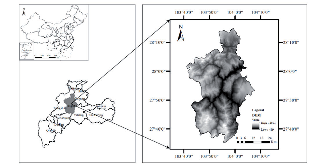
Daguan County is affiliated with Zhaotong City, Yunnan Province. It is located in the northeast of Yunnan Province, the northeast of the Yunnan Wumeng Mountain area, which extends from 27°36’ to 28°15’N latitudes and from 103°43’ to 104°07’E longitudes (Fig. 1). The Daguan borders Yiliang County in the east, Zhaoyang District in the south, Yongshan County in the west, and Yanjin County in the north, with a total area of 1721 square kilometers. As it is located on the northern edge of the Yunnan-Guizhou Plateau buffer, the terrain is mainly found in the mountainous area with high altitude. It receives an average of 1054.1 mm of annual rainfall with an annual average temperature of 15.14°C. There are weak geological environment conditions here. Collapses, landslides, debris flow, unstable slopes, and other geological disasters usually occur. It is one of the key counties in the geological disaster prevention and control in Yunnan Province. The regional ecosystem has been damaged, and ecological problems have increased due to the ecologically fragile and human disturbances. Therefore, it is of great significance to identify the key area of land consolidation and ecological restoration in Daguan County. Specialized projects could be implemented to adapt to local conditions. The present study could help to provide references for the implementation of strategies.
Data Collection
The 2022 land use data was extracted from the Landsat 8 OLI_TIRS with a spatial resolution of 30 m (cloud cover is less than 10%) from the EarthExplorer (https://earthexplorer.usgs.gov/). To obtain high-quality imaging data, the images were selected in July for rich vegetation cover. Using ENVI 5.3, geometric correction, band combination, and radiometric calibration were conducted. According to previous studies [17, 18], water, forestry, cropland, grassland, unused land, and construction land were categorized. A series of random precision evaluation points were created to validate precision, and the overall precision of land use classification was more than 85%, which could meet analysis requirements. The DEM data used in the present study was the ASTER GDEM V3 with a spatial resolution of 30 m, which was collected from the Geospatial Data Cloud (http://www.gscloud.cn/). The data on soil types were obtained from the World Soil Database (HWSD) with a spatial resolution of 1 km². The precipitation data with a spatial resolution of 30 m in 2022 was downloaded from the Resources and Environmental Science Data Center of the Chinese Academy of Sciences. Evapotranspiration data were collected from the Tibetan Plateau Data Center (TPDC) with a resolution of 1000 m. The plant’s available water content was obtained from the International Soil Reference and Information Center (ISRIC), with a resolution of 250 m. The Root-Restricting Layer Depth data were extracted from the previous study’s data with a resolution of 1000 m [19]. All data were unified into 30 m grids for analysis.
Methods
Ecological Source Identification and Ecological Resistance Surface Construction
Ecological source refers to an area with high ecological environment quality and high ecological stability and expansibility. The present study uses the MSPA model to screen for ecological sources. The MSPA model has 7 types of core, islet, perforation, edge, loop, bridge, and branch ecological structures [20]. Core areas represent large ecological patches, which are the source of multiple ecological processes. It plays an important role in biodiversity protection and the ecological environment. According to the previous studies, water and forestry were set as the foreground, and other land use types greatly disturbed by human activities were taken as the background. The MSPA core area in Daguan County was extracted. After that, the patch area of more than 10 km2 was extracted as the ecological source. It has been demonstrated that the species activities between ecological sources will be affected by different natural landforms, land use covers, and human disturbances [21]. Ecological resistance represents the difficulty of species dispersal, migration, or gene flow. Based on previous studies, the inverse of habitat quality can be used to construct the ecological resistance surface [22, 23]. The InVEST (Integrated Valuation of Ecosystem Services and Tradeoffs) model was utilized to calculate the habitat quality.
Circuit Theory
The ecological corridor is an important channel connecting ecological sources and the main channel of material circulation, energy flow, and information transmission of the ecosystem. Circuit theory originated in the study of electrical engineering. In landscape ecology, according to the theory, the relative importance of ecological corridors can be reflected in the intensity of current among sources [24]. As a result, the species dispersal and migration laws can be predicted, and the mobile pathways can also be identified. In the present study, after ecological source identification and ecological resistance surface construction, the Circuit Theory was introduced to identify the ecological corridors, which can better simulate the random migration of species and identify the minimum cost path among ecological sources [25]. All the ecological sources can be seen as the ‘nodes’ in the circuits. Using the Linkage Mapper tool to extract the ecological corridors, the Network Adjacency Method is Cost-Weighted & Euclidean, and the Truncate Cost-Weighted Distance Threshold is 200,000 according to the software user guide.
Identifying Key Areas for Land Consolidation and Ecological Restoration
The identification of key areas in land consolidation and ecological restoration is the ecological barrier point in ecological networks, which are the hindrances in species dispersal, migration, or gene flow [26]. Ecological connectivity can be significantly improved by removing ecological barriers. According to the Circuit theory, ecological barriers were identified by calculating the magnitude of the cumulative current recovery values. By using the mobile window method to search and detect, the higher the value of the barrier points, the greater the resistance to connectivity among the ecological sources. The Barrier Mapper tool of the Circuitscape plug-in in ArcGIS was used to identify the ecological barriers with parameters set to a minimum detection radius of 100 meters, a maximum detection radius of 500 meters, and a radius step value of 300 meters. The ecological barrier points are the main areas where land consolidation and ecological restoration should be implemented.
Ecological Effects Assessment of Land Consolidation and Ecological Restoration
After identifying key areas of land consolidation and ecological restoration, special projects were pre-set in these areas. According to the Law of the People’s Republic of China on Soil and Water Conservation, land reclamation is prohibited in places with slopes greater than 25 degrees. The ecological barrier areas with slopes greater than 25 degrees were restored into forestry, and the non-ecological land with slopes less than 25 degrees was implemented with land consolidation and reverted to cultivated land. A comprehensive ecological effect index was introduced to evaluate the ecological effects of land consolidation and ecological restoration from water and soil conservation, carbon storage, and habitat quality. The indexes of the ecological effects and their formulas and descriptions are listed in Table 1. The indexes of water and soil conservation, carbon storage, and habitat quality were calculated by InVEST [27-29].
Results and Discussion
Ecological Source Identification and Ecological Corridor Construction
Based on the MSPA, ecological core areas were identified. As a result, 11 ecological sources were obtained. The total area of the ecological sources was 322.93 km2 (Fig. 2). The ecological sources with relatively larger areas are mainly distributed in the study area’s northern, eastern, and southern parts. The ecological sources in this area occupy 70% of the county’s ecological sources, which indicates that the ecological environment in these regions is superior. As the slope in this area was relatively at a higher level, human activities were rare. Large areas of forestry are distributed here. It creates a good living space for terrestrial organisms. There are relatively few ecological sources in the central and western regions, as the terrain is relatively flat. Human activities such as expanding construction land, agricultural production, and industrialization are taking place here.
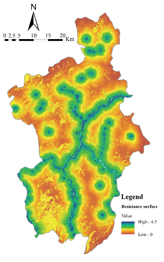
The results of the ecological resistance surface showed an obvious heterogeneity in its spatial distribution (Fig.3). Multiple dotted high-resistance areas are present in the north, west, and east. At the same time, numerous chain-like high-resistance areas are presented in the middle and south of the study area. The dotted areas of high resistance are the main areas of frequent human activity near the ecological sources. A certain number of villages are distributed here. The chain-shaped high-resistance areas are mainly the expressways and railways in the study area.
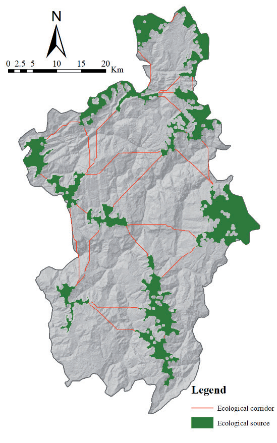
Table 1.
The indexes of ecological effects assessment.
Based on the Circuit Theory, 25 ecological corridors were identified, totaling 20.84 km (Fig. 2). Ecological corridors in the south and north of the study area are relatively shorter, whereas the central area has relatively longer corridors. Most of the ecological corridors present an east-west connection pattern, and a small number of corridors show a north-south connection pattern. Ecological corridors and ecological sources together form a network structure. Areas with a large span of the ecological corridor are somewhere with relatively flat terrain and more frequent human activity.
Key Areas of Land Consolidation and Ecological Restoration Identification
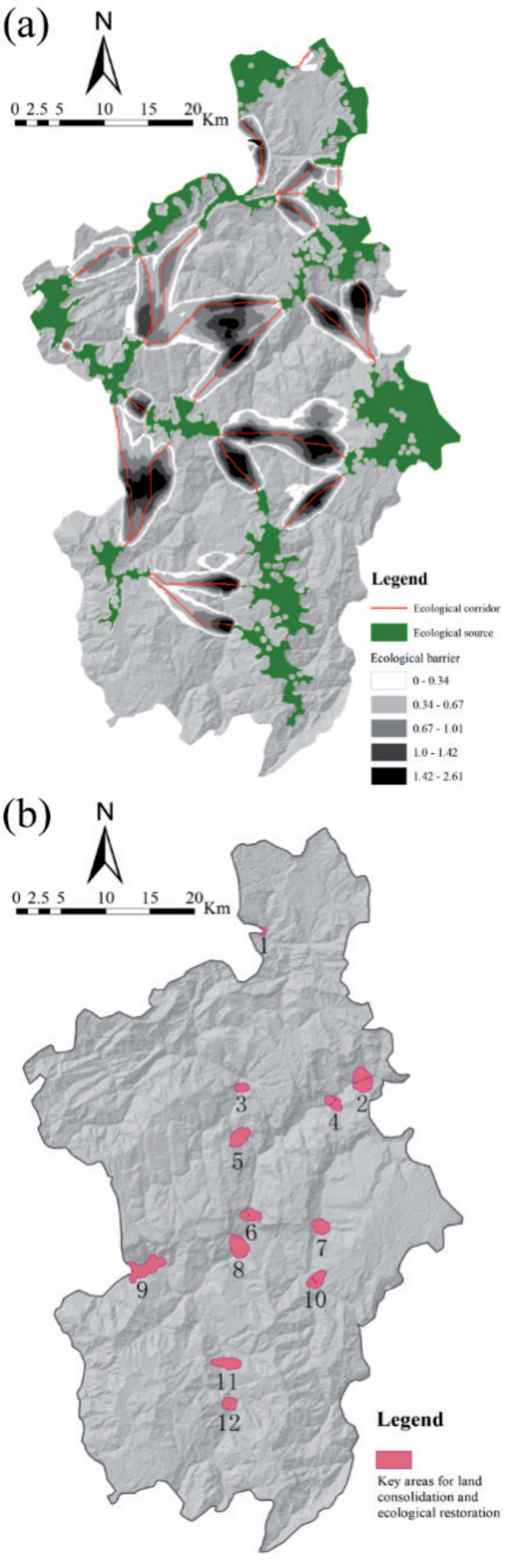
In the present study, the ecological barrier point is considered the key area for land consolidation and ecological restoration. The removal of barrier points helps to improve the connectivity of the overall ecosystem. A series of ecological barrier areas were identified using the Barrier Mapper tool of the Circuitscape plug-in in ArcGIS (Fig. 4a). Using the Natural Break tool of ArcGIS, 5 levels of ecological barriers were obtained. The areas with the highest values in the 5 ecological barrier levels are the identified key areas for land consolidation and ecological restoration. A total of 12 ecological barrier points were identified (Fig. 4b) with an area of 37.16 km2. Ecological barrier points and land use data were overlayed. The land use in the ecological barrier points is mainly forestry with relatively low vegetation cover, cultivated land with a high slope level, and settlements and factories along the road. It is necessary to carry out land consolidation and ecological restoration and optimize the landscape pattern to promote beneficial ecological processes and inhibit harmful disturbance.
Results of Ecological Effects Assessment
Land consolidation and ecological restoration projects were pre-arranged for the identified key areas. Although cultivated land is not the most ideal habitat for the species, it can also provide temporary shelter and food resources to maintain the continuity of ecological corridors. At the same time, the ecological barriers in the identified key areas need to be removed as much as possible to reduce the overall ecological risk of the corridor and leave ample space for species to move. The ecological barrier areas with slopes greater than 25 degrees were restored into forestry, and the non-ecological land with slopes less than 25 degrees was implemented with land consolidation and reverted to cultivated land. An ecological effects assessment was conducted to analyze the effects of pre-set land consolidation and ecological restoration projects from water and soil conservation, carbon storage, and habitat quality.
According to the results of ecological effects analyzed before and after the land consolidation and ecological restoration projects were pre-set, water and soil conservation, carbon storage, and habitat quality of the barrier areas are improved at different levels (Fig. 5). The improvement is even more pronounced in areas with more complex terrain. The results may relate to the proportions involved in ecological restoration, as the more ecological land could be brought by ecological restoration, the more ecological effects could be provided. Therefore, it is even more important to identify the main areas of land consolidation and ecological restoration.
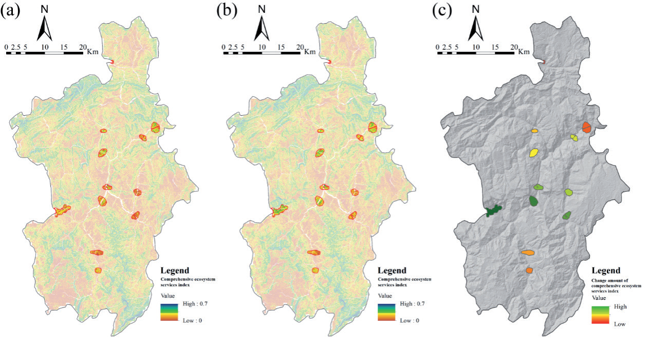
The comprehensive ecological effect index was analyzed before and after the project’s pre-set (Table 2). Although carbon storage, habitat quality, water, and soil conservation only improved by 19.35%, 8.15%, and 1.72%, respectively, the comprehensive ecological effect index improved by 29.42%. It seems like changes in the comprehensive ecological effect index are not entirely related to the identified key area’s size. The key areas with more changes in the comprehensive ecological effect index are distributed in the middle of the study area (Fig. 6). It may provide an idea for conducting the order of land consolidation and ecological restoration projects. Areas with more improvement in comprehensive ecological effects should be given priority, as more ecosystem service functions can be provided.
Fig. 5.
a) and b) are the carbon storage before and after the project’s pre-set; c) and d) are the habitat quality before and after the project’s pre-set; e) and f) are the soil and water conservation before and after the project’s pre-set.
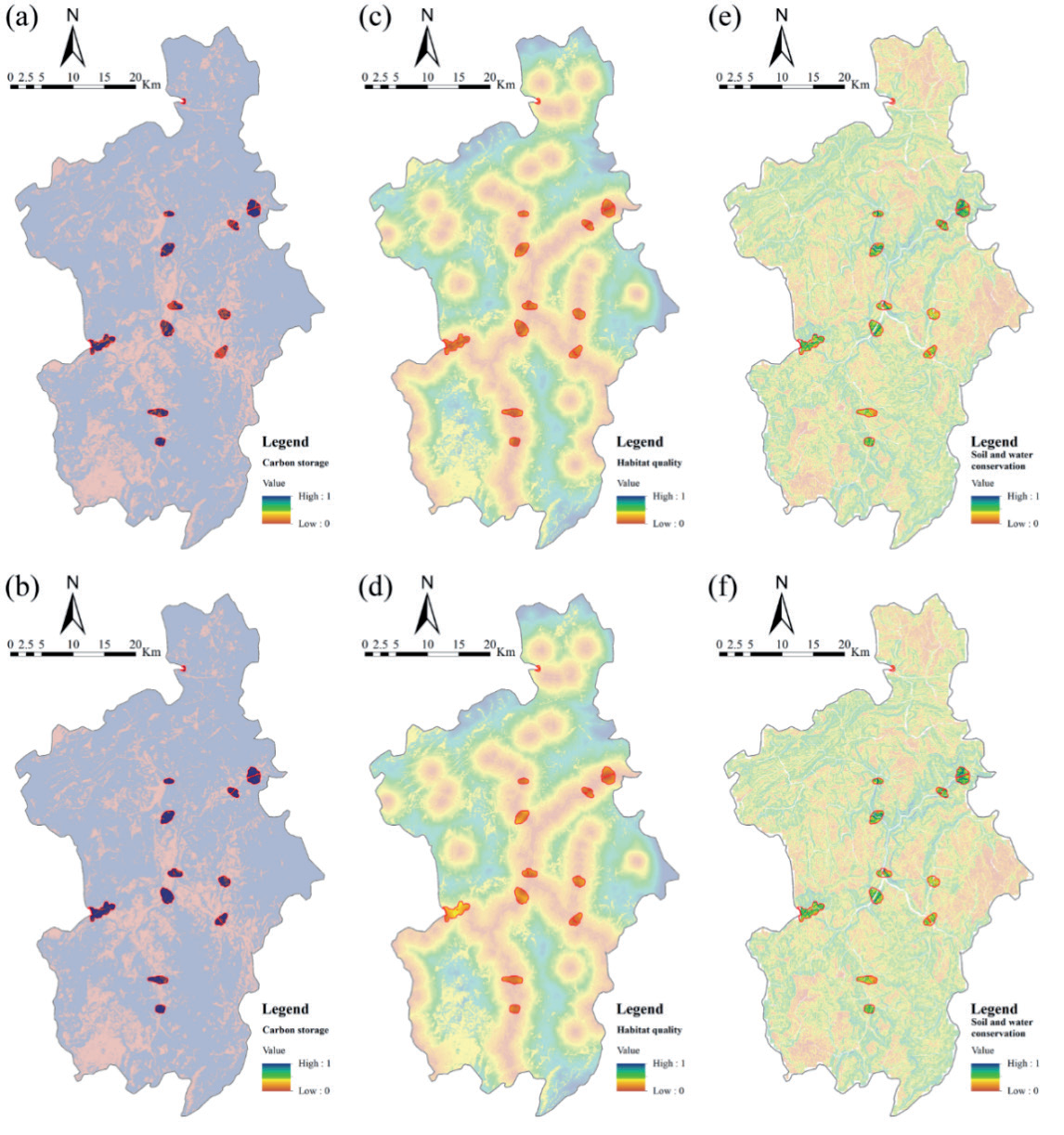
Table 2.
Ecological Impact Assessment Indicators Before and After Land Rehabilitation.
As found in the present study, land consolidation and ecological restoration can improve the regional ecosystem. Ecosystem services, such as water and soil conservation, carbon storage, and habitat quality, can be improved. Previous studies also support these findings [30, 31]. It has been reported that land consolidation and ecological restoration often involve integrated measures targeting various ecosystem components, such as forests, grasslands, wetlands, and water bodies [4]. This holistic approach helps to maintain and restore the interconnectedness and integrity of the ecosystem. By protecting and restoring habitats, these activities can promote the return of native species and increase biodiversity, which is crucial for ecosystem resilience and stability. Previous studies on land consolidation have demonstrated that soil remediation and fertilization can increase soil fertility and productivity [32, 33]. This, in turn, supports plant growth and enhances the ecosystem’s ability to provide services like food production and nutrient cycling. Ecological restoration practices can also help reduce the risk of natural disasters such as landslides and floods [34]. Land consolidation and ecological restoration can improve the regional ecosystem by enhancing its integrity and services, mitigating degradation, and promoting resilience and adaptation. These efforts are crucial for maintaining the health and productivity of ecosystems and supporting human livelihoods and well-being [35].
In the present study, the ecological barrier points are identified as the main areas where land consolidation and ecological restoration should be conducted using Circuit theory and spatial analysis methods. The identified ecological barrier points often correspond to regions with significant ecological degradation or important ecological functions [36]. By focusing on these areas, ecological restoration efforts can more effectively promote the recovery of ecosystems, improving biodiversity, soil quality, and water resources. The land consolidation and ecological restoration projects implemented here can prevent further degradation and erosion. It helps to maintain the productivity and resilience of ecosystems, ensuring their ability to provide ecological services [37, 38]. Previous studies have found that identifying and restoring key areas can enhance the connectivity of landscapes, facilitating the movement of species and the maintenance of ecological processes, which is crucial for maintaining ecological balance and promoting biodiversity [39, 40]. By identifying key areas and conducting targeted measures, the limited resources such as funds, labor, and materials can be more effectively allocated. This ensures that land consolidation and ecological restoration activities are targeted at the most critical and degraded areas, maximizing the impact of the efforts. The present study’s methods and ideas can help promote land consolidation and ecological restoration more pertinently.
Fig. 6.
a) and b) are the comprehensive ecological effect index before and after the project’s pre-set; c) shows changes in the comprehensive ecological effect index for each identified key area.
The assessment of pre-set land consolidation and ecological restoration projects can indeed aid in planning the implementing time order. During land consolidation and ecological restoration planning, determining the implementation time order is difficult. Based on the results of the effects assessment of pre-set projects, the time order of projects’ implementation can be determined. Projects in ecological barrier points where land consolidation and ecological restoration can bring more comprehensive ecological benefits should be implemented in advance. The conducted pre-set project effects assessment can help with land consolidation and establishing ecological restoration planning. By understanding the needs of land consolidation and ecological restoration, resources can be allocated more efficiently, ensuring that critical tasks are prioritized and sufficient resources are available for each phase. It also contributes to long-term ecological health and resilience, as key areas for maintaining regional ecological function can be preferentially consolidated and restored. The present study provides valuable insights into the feasibility of the land consolidation and ecological restoration project, which ensures the project is more likely to succeed and achieve its intended goals.
Conclusions
The study takes Daguan County in Yunnan Province as a case; the key areas of land consolidation and ecological restoration were identified based on Circuit theory. After that, according to the terrain’s suitability, land consolidation and ecological restoration projects were pre-arranged, and the effects of the projects’ layout on the ecosystem were evaluated. The results showed that the total area of the ecological sources in Daguan County was 322.93 km2, which are mainly distributed in the study area’s northern, eastern, and southern parts. A total of 12 ecological barrier points with an area of 37.16 km2 were identified as the key areas of land consolidation and ecological restoration. By assessing the ecological effects of the pre-set projects, ecosystem services such as water and soil conservation, carbon storage, and habitat quality can be improved by implementing land consolidation and ecological restoration projects, respectively. Identifying the key areas can promote land consolidation and ecological restoration more pertinently. Projects in the middle of Daguan County that can improve comprehensive ecological effects should be given priority, as more ecosystem service functions can be provided. The results of the effects assessment of pre-set projects can help plan land consolidation and ecological restoration implementation. Based on the analysis of requirements identification and effect assessment on land consolidation and ecological restoration, the project is more likely to achieve its expected goals.

