

Introduction
Arable land is a fundamental resource that underpins human survival and supports societal development [1]. In China, challenges such as regional imbalances in development and varying quality of arable land have become major constraints to the advancement of agricultural modernization [2]. In recent years, with the rapid progress of industrialization and urbanization, land resources have often been utilized inefficiently or excessively, leading to a significant decline in the total area of cultivated land [3]. In response, the central government’s No. 1 document for 2025 reiterates strict control over the total amount of arable land and the policy of “requisition-compensation balance.” The report of the 20th National Congress of the Communist Party of China also clearly emphasizes the importance of safeguarding the 120 million hectares redline for arable land, aiming to ensure both the quantity and quality of farmland and to provide policy support for its sustainable use [4]. The consistent attention paid by the party and the state to arable land issues highlights its critical role as a foundational resource for people’s livelihoods.
To enhance the utilization of this scarce resource, the concept of multifunctionality has gradually extended from the agricultural domain to the broader context of land use [5]. The multifunctionality of arable land refers not only to its traditional productive function – such as food production – but also to other functions essential to human survival and development [6]. With China’s transition into an industrial society, the role of arable land has evolved from a single production-oriented function in agrarian society to a more comprehensive one that encompasses both living and ecological functions. These functions are interrelated and mutually reinforcing, primarily coordinated through the triad of “production-living-ecological” functions to meet the growing needs of society [7]. Therefore, evaluating the coupling coordination degree of these three functions is not only essential for ensuring national food security but also serves as a foundation for exploring the intrinsic linkages of farmland multifunctionality. Such an evaluation is of great significance for promoting sustainable agricultural production and achieving high-quality agricultural development. It provides empirical support for differentiated strategies in arable land protection and management.
Scholars have approached the study of arable land multifunctionality by first analyzing its conceptual foundation, generally recognizing it as an extension of the multifunctional concept within the agricultural domain [8]. Evaluations of arable land multifunctionality have been conducted from multiple dimensions [9], primarily through the construction of multifunctional evaluation frameworks that categorize functions into dimensions such as economic output, social security, crop supply, ecological services, and landscape recreation [10]. These efforts have laid a theoretical foundation for further research in this field. In recent years, both domestic and international scholars have focused on two major aspects of arable land multifunctionality: value assessment and management. The former primarily involves the quantitative valuation of multifunctionality and the analysis of its influencing factors [11], while the latter emphasizes spatiotemporal evolution [12], coupling coordination degree [13], and trade-off–synergy relationships [14], ultimately leading to proposals for differentiated arable land management strategies. Both research streams have, to varying degrees, advanced the understanding of land use and conservation and broadened the analytical scope of arable land multifunctionality studies. Methodologically, studies commonly employ the coupling coordination degree model [15] and Spearman’s rank correlation model [16] to identify the relationships among various functions. Spatial distribution and clustering of multifunctional attributes are often depicted using cluster analysis [17] and spatial autocorrelation models [18]. In terms of research scale, studies have primarily focused on different administrative levels, including county, city, provincial, and national levels [19]. In summary, existing research has played a crucial role in clarifying the conceptual connotation of arable land multifunctionality, constructing evaluation systems, estimating functional values, and delineating functional zones. These findings have provided valuable references for government policies on arable land protection and utilization. However, current studies have paid relatively limited attention to the spatiotemporal characteristics of the interrelationships among different functions and the identification of their driving factors. Moreover, most studies have focused on major grain-producing areas, with insufficient emphasis on grain-consuming and grain-balanced regions.
The Xinjiang Uygur Autonomous Region (hereafter referred to as Xinjiang), located in the northwestern frontier of China, despite leading the nation in agricultural modernization, faces mounting ecological and land use challenges. These issues stem from its weak economic foundation, vast territory with sparse population, arid climate, water scarcity, and extensive land management practices. As a result, problems such as soil erosion and farmland abandonment have become increasingly prominent, and the degree of coordinated utilization of arable land varies significantly across different regions [20]. Xinjiang possesses a substantial reserve of strategic arable land resources and is undergoing a strategic transformation in its role in grain production – from “intra-regional balance with slight surplus” to “intra-regional surplus with national supply responsibilities.” Although limited by structural shortages in climate and water resources, the region still holds considerable potential for farmland utilization [21]. Against this backdrop, examining the spatiotemporal patterns of the coupling coordination degree among the production, living, and ecological (“three-function”) dimensions of arable land across various prefectures in Xinjiang and identifying the key factors influencing coordinated farmland development is of great significance. Such research enriches the discourse on multifunctional arable land in arid and grain-balanced regions and aids in recognizing spatial disparities and coordination deficiencies in farmland utilization. It provides a theoretical basis and decision-making reference for developing regionally appropriate policies for farmland protection and utilization. Ultimately, it supports national food security and promotes the coordinated development of the “three-function” system of arable land in Xinjiang.
Materials and Methods
Overview of the Study Area
Xinjiang is located between 73°46′ and 117°96′ east longitude and 34°25′ and 49°50′ north latitude (Fig. 1). The terrain of Xinjiang is characterized by “three mountain ranges surrounding two basins.” The climate is temperate continental arid, characterized by low precipitation, high evaporation, and significant diurnal temperature variations.
Theoretical Framework
Based on cultivated land system theory and the theory of agricultural multifunctionality, a theoretical framework is constructed to investigate the coupling coordination of the “production-living-ecological” functions of cultivated land and its driving factors (Fig. 2). Cultivated land system theory conceptualizes cultivated land as a dynamic and open system, emphasizing the interactions among internal components (such as soil, water, and biota) as well as their interactions with the external environment. It highlights cultivated land as a complex system formed by the coupling of natural ecosystems and socio-economic systems. This theory lays the foundation for understanding the production, living, and ecological functions of cultivated land, suggesting that optimizing the internal structure and functional processes of the system can enhance the overall utilization efficiency and multifunctionality of cultivated land. The theory of agricultural multifunctionality further reveals the multiple roles of cultivated land, indicating that it serves not only as a critical space for agricultural production but also as a safeguard for farmers’ livelihoods and a vital component of ecological systems. A combination of natural environmental conditions and human demands influences these multifaceted functions.
The conversion of land into cultivated land essentially reflects the transformation of natural resources driven by human demand for agricultural products. This process underscores the fundamental productive capacity of cultivated land. With the advancement of agricultural practices and scientific technologies, the production process has evolved beyond traditional inputs such as water resources to include chemical inputs – such as fertilizers and plastic films – designed to enhance land productivity. However, since cultivated land originates from the transformation of soil, it inherently possesses ecological attributes. The extensive use of production materials inevitably imposes environmental stress on the soil ecosystem, thereby undermining the ecological functions of cultivated land and reducing its capacity for sustainable agricultural production. Therefore, maintaining the ecological functionality of cultivated land is vital for ensuring its productive capacity. Additionally, the unique relationship between humans and land embedded in cultivated land signifies that, beyond its role in production, it also indirectly fulfills functions that support livelihoods. As an indispensable resource for agricultural production, cultivated land not only satisfies the basic material and income needs of rural residents but also offers employment opportunities that are essential for maintaining social stability.
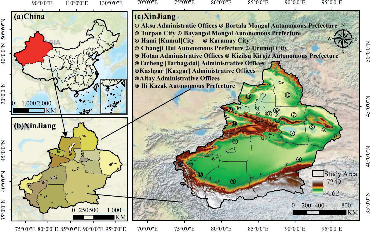
Fig. 2.
Theoretical framework for the coupling coordination of the “production–living–ecological” functions of cultivated land and the detection of its driving factors.
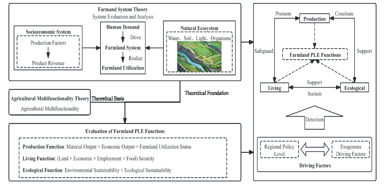
The production, living, and ecological functions of cultivated land serve as subsystems within the “production-living-ecological” functional system of cultivated land. These functions both promote and constrain each other, with both positive interactions and negative impacts. To fully utilize the multifunctionality of cultivated land, it is essential to consider the interactions among these functions from a system perspective. The production function is the core of the “production-living-ecological” functions of cultivated land, as it generates various agricultural products to meet human material and economic needs. However, the strength of the production function directly influences the living and ecological functions of cultivated land. Weaker production functions may lead to a decline in human living standards, while stronger production functions may have adverse effects on the natural ecosystem, such as the excessive use of water resources, fertilizers, and plastic films. Regions with a strong living function of cultivated land typically exhibit higher agricultural economic benefits and food security, which in turn enhance farmers’ willingness to engage in agricultural production, thus promoting the production function. Additionally, to ensure the sustainability of agricultural economic benefits, it is crucial to strengthen the ecological function of cultivated land by adopting scientific management practices to reduce the overuse of land resources and prevent phenomena such as soil erosion and chemical pollution. The ecological function of cultivated land supports both production and living functions; a robust ecological function not only increases per-unit land yield and value but also satisfies human ecological needs, providing healthier agricultural products and improving living standards. Therefore, based on the aforementioned theory and analysis, it is evident that the key to the coordinated development of the “production-living-ecological” functions of cultivated land lies in maximizing the production function while balancing the living and ecological functions. By coordinating the interactions among these functions, the efficiency of land use can be enhanced, and the sustainable utilization of cultivated land resources can be achieved.
Evaluation System for the “Production-Living-Ecological” Functions of Cultivated Land
Based on the above theoretical framework, the study divided the sub-functions of arable land and selected 12 indicators to establish the evaluation system of the three functions of arable land in 14 prefectures and municipalities in Xinjiang (Table 1) [22-25].
(1) Production Function: The production function of cultivated land corresponds to agricultural production capacity. Therefore, the evaluation of the production function focuses on three aspects: yield, output value, and land utilization. Yield is measured by grain yield per unit area, representing the level of grain production on cultivated land. The economic value of agricultural production is reflected in the per-unit land output value. The intensity of land utilization is assessed using the cropping index and land reclamation rate, with the former indicating the level of agricultural production and the latter reflecting the extent of land reclamation.
(2) Living Function: The living functions of farmland highlight its unique human-land relationship attributes, providing basic social security for the farmland, economy, employment, and food required for human survival. In this study, per capita agricultural output value is used to reflect the economic level of agricultural production. Per capita grain availability and per capita arable land area are selected to measure the degree of food security and basic land security for urban and rural residents, respectively. The capacity of rural employment is assessed by the number of employed individuals in rural areas, with a higher employment capacity contributing to social stability and alleviating employment pressures.
Table 1.
Evaluation system of PLE functions of farmland.
(3) Ecological Function: The ecological function of cultivated land is primarily reflected in its role in environmental protection and biodiversity maintenance within agricultural production. In the northwest region of China, particularly Xinjiang, water resources are scarce and unevenly distributed. The climate is arid, with large diurnal temperature variations, and the majority of cultivated land consists of both irrigated and dryland types. Additionally, the rapid expansion of cultivated land in recent years has exacerbated ecological issues related to cultivated land in Xinjiang. This study selects fertilizer and plastic film usage intensity to reflect the environmental burden of agricultural production. Per-unit land water consumption is used to indicate the degree of water resource depletion, and the proportion of irrigated land is chosen to reflect biodiversity in cultivated land. A higher proportion of irrigated land is more favorable for maintaining soil moisture, enhancing soil microbial activity, improving soil structure, and thereby promoting root development and nutrient absorption in crops.
The study employs the entropy method to determine indicator weights. To address the comparability of indicators, the study applies the range normalization method for data dimensionless processing. The calculation methods for positive and negative indicators are as follows:
Positive indicators:
Negative indicators:
In the equation, Xij represents the dimensionless value, xij is the observed value of the j indicator for the i prefecture, and xjmax and xjmin represent the maximum and minimum values of the j indicator, respectively.
Subsequently, the values for the production function, living function, and ecological function of cultivated land are obtained by weighting through a composite index model. The calculation method is as follows:
Where F is the sub-functional evaluation index of arable land, j represents the jth indicator, n represents the total number of evaluation indicators of this function, and wj is the weight of the jth indicator. The interval of F is [0,1], and the larger the value is, the stronger the level of the ‘three living’ function of arable land is.
Coupling Coordination Degree Model
The coupling coordination degree model is commonly used to evaluate the interactions and the degree of coordination between systems [13]. In this study, the coupling coordination degree between the production, living, and ecological functions of cultivated land in Xinjiang is calculated from an overall perspective using the coordination degree algorithm, based on the cultivated land “production-living-ecological” function evaluation system established in Table 1. The calculation formula is as follows:
Where C is the degree of coupling between sub-functions, Ft represents the evaluation score of the tth sub-function, T characterizes the evaluation index of the ‘three living’ functions, Wt is the weight of the tth sub-function, and D is the degree of coordination of the ‘three living’ function coupling. According to the characteristics of the calculated values of the coupling and coordination degree of the ‘three living’ functions of arable land in the study area, the calculated values were classified into six grades and two types based on the existing studies (Table 2) [12].
Spatial Autocorrelation Model
This study employs the spatial autocorrelation model to analyze the spatial aggregation characteristics of the coupling coordination degree of the “production-living-ecological” functions of cultivated land in Xinjiang [18]. The spatial autocorrelation model calculates both the global Moran’s I and the local Moran’s I to obtain information on global and local autocorrelation. In ArcGIS ArcToolbox, select the Spatial Autocorrelation module, set Conceptualization of Spatial Relationships to CONTIGUITY_EDGES_CORNERS, set Distance Method to EUCLIDEAN_DISTANCE, and set Standardization to ROW (spatial weight standardization). Global autocorrelation measures the clustering pattern of attribute distribution across the entire study area, while local autocorrelation focuses on clustering within specific regions of the study area. The calculation formula is as follows:
In the formula, xi and xj represent the coupling coordination degree values of the “production-living-ecological” functions of cultivated land in the i-th and j-th regions, respectively. x̄ denotes the mean coupling coordination degree of the “production-living-ecological” functions of cultivated land across all regions. wij represents the spatial weight matrix, and S² is the variance of the coupling coordination degree of the “production-living-ecological” functions of cultivated land in each region. In this study, both the global Moran’s I (GM) and local Moran’s I (LM) values range from [-1, 1]. Suppose the calculation result is greater than 0. In this case, it indicates a positive spatial correlation in the coupling coordination degree of the “production-living-ecological” functions, with a higher value reflecting a more significant spatial correlation. If the result is less than 0, it suggests a negative spatial correlation, with a smaller value indicating greater spatial heterogeneity. A consequence of 0 implies spatial randomness in the coupling coordination degree of the “production-living-ecological” functions of cultivated land.
Geographical Detector
As a complex system coupling both natural ecology and socio-economic factors, cultivated land is influenced by multiple drivers. This study selects eight indicators from four aspects: urbanization level, agricultural development level, industrial development level, and regional policy level (Table 3) to analyze the driving factors of the coupling coordination degree of the “three functions” of Xinjiang’s cultivated land in 2009, 2015, and 2020.
Table 2.
Levels and types of the coupling coordination extent of farmland PLE functions.
Table 3.
Indicators of driving factors affecting the coupling and coordination extent of farmland PLE functions.
This study incorporates the actual conditions of Xinjiang to select the indicators for each driving factor. The proportion of the urban population and urban land area represents the urbanization level. Population urbanization implies a relative decrease in agricultural labor, while land urbanization indicates the encroachment of urban land expansion on surrounding cultivated land [26]. Agricultural development level is reflected by the proportion of grain sown area and the share of the primary industry. The former indicates preferences for cropping structure, while the latter reflects the importance placed on agriculture [27]. The level of industrial development is measured by the number of industrial enterprises above a certain scale and the share of the secondary industry. Industrial enterprises above a certain scale can create employment opportunities, and a higher industrial output ratio indicates a greater likelihood of agricultural workers shifting or abandoning farming, which can lead to reduced agricultural production or land abandonment [28]. The regional policy level is represented by the level of agricultural mechanization and the area of soil erosion control, corresponding to the implementation effects of local agricultural modernization and soil and water conservation policies.
Geodetector, a spatial analysis-based method, is designed to detect interaction relationships among different geographical factors and quantify their impacts on the target research object [29]. By assessing the consistency in the spatial distribution of various geographical factors, it identifies which factors significantly influence the distribution pattern of the target object. Given its capability to explore the spatial distribution patterns of the target object and reveal underlying driving factors from both single-factor and multi-factor interaction perspectives, this study first employs the natural break classification method to conduct discretization and classification of driving factor data. Subsequently, the factor detection and interaction detection modules within Geodetector are utilized to investigate the driving factors. The computational formula is as follows:
Where q characterizes the influence factor, the range is [0,1], and the larger value corresponds to the stronger explanatory power of the dependent variable; N is the total number of cities and municipalities in Xinjiang; σ2 is the variance of the coupling degree of the cultivated land of Xinjiang cities and municipalities in the ‘three living’ function; L represents the number of natural breakpoint layers; Nh represents the number of cities and municipalities with influence factor divided in layer h; σh2 characterizes the variance of the coupling degree of the ‘three living things’ functions of arable land in the prefecture and city where the influence factor is classified in the h layer. Interaction factor detection is to calculate the size of q(x1∩x2) when two factors, such as x1 and x2, interact with q(x1) and q(x2) of the dependent variable and to determine whether the two factors have enhanced, weakened, or independent effects on the dependent variable when they act together.
Source of Data
The research data primarily comes from the Xinjiang Statistical Yearbook for the years 2010–2021. Data on plastic mulch usage for 2009 is derived from the sum of data from various cities and counties in the Xinjiang Survey Yearbook. Data for certain years is sourced from the annual statistical bulletins on national economic and social development of various prefectures, cities, and counties. Agricultural output data for each county and city are sourced from the “Total Output Value of Agriculture, Forestry, Animal Husbandry, and Fisheries” table in the Xinjiang Statistical Yearbook for each prefecture-level city and county (city). The total output value of agriculture, forestry, animal husbandry, and fisheries includes the output values of agriculture, forestry, animal husbandry, and fisheries, as well as the services provided by those sectors. The agricultural output value used in this paper refers specifically to the output value of crop cultivation. The data on arable land area are sourced from the Second and Third National Land Surveys, with the sample period spanning from 2009 to 2020.
Results and Discussion
Analysis of Spatiotemporal Evolution of the “Production-Living-Ecological” Functions of Cultivated Land
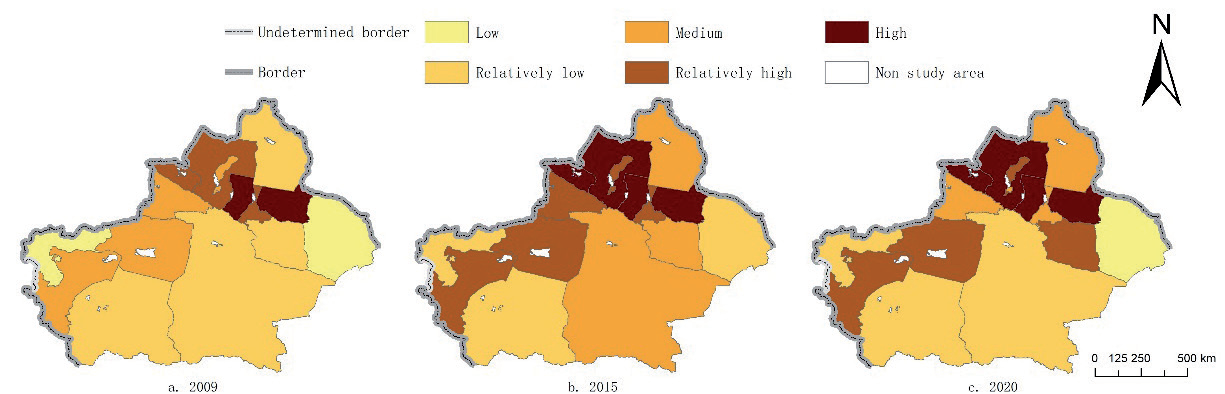
As illustrated in Fig. 3, the production function of cultivated land in Xinjiang exhibited a fluctuating upward trend throughout the study period, with an average increase of 0.0621. Among all prefecture-level cities and prefectures, only Urumqi, Hami, and the Ili Kazakh Autonomous Prefecture showed no growth in cultivated land production, while other regions experienced varying degrees of improvement. Notably, Turpan and Altay witnessed growth exceeding 100%. Spatially, production function values ranged from [0.08, 0.52], with northern Xinjiang generally demonstrating higher production function levels than southern Xinjiang. Specifically, regions with strong production functions were primarily distributed in the Junggar Basin north of the Tianshan Mountains, the Tarim River Basin, and the Yili River Valley. This can be attributed to their flat topography, abundant water resources, high grain yield per unit area, and high land reclamation rate—conditions conducive to large-scale agricultural production. In contrast, areas with weak production functions were located in eastern and western Xinjiang, specifically the junction of the southern Tianshan and Kunlun Mountains and the Hami Basin. Limited by natural constraints, such as water scarcity and farmers’ preference for cash crops, these regions experienced no significant improvement in the cultivated land production function. For example, Hami’s grain-sown area decreased by 10% during the study period, maintaining its weak production function level.
Fig. 4 depicts a fluctuating upward trend in the living function of cultivated land in Xinjiang, with the average score increasing by 0.0136 over the study period. Except for Karamay, Urumqi, Hami, Changji Prefecture, Ili Prefecture, and Aksu Prefecture – where no growth was observed – all other regions exhibited increasing trends in cultivated land living function, with Altay achieving a 57% increase. Spatially, the living function values ranged from [0.04, 0.59], with most prefecture-level cities and prefectures displaying relatively weak living function levels. Areas with weaker living functions were primarily distributed in the Tarim Basin, the southwestern Altai Mountains, and the Hami Basin, attributed to low per capita agricultural output values, limited per capita grain availability, and a minor agricultural share in the industrial structure. Conversely, regions with stronger living functions were concentrated north of the Tianshan Mountains and in the Turpan Basin. Notably, only Karamay attained a strong living function level, driven by its extreme land-to-population ratio, with rural per capita cultivated land area measuring 30.947, 21.803, and 26.892 hectares in 2009, 2015, and 2020, respectively.
Fig. 3.
Spatiotemporal distribution of farmland production function. Note: The map is based on the standard map with review number GS(2022)1873, downloaded from the website of the Standard Map Service of the State Administration of Surveying, Mapping, and Geoinformation. There have been no modifications to the boundary of the base map. The same as below.
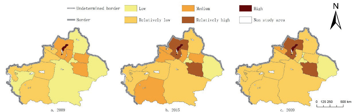
As shown in Fig. 5, the ecological function of cultivated land in Xinjiang followed a fluctuating downward trend during the study period, with an average score decrease of 0.0371. Only Karamay, Turpan, Hami, Altay, and Hotan witnessed growth in cultivated land ecological function – with Turpan achieving a 150% increase – while all other regions experienced declines of varying degrees. Spatially, ecological function scores ranged from [0.14, 0.68], with regions of relatively strong ecological function scattered primarily north of the Tianshan Mountains and in the Hotan River Basin. These areas benefit from favorable natural endowments and robust ecological self-recovery capabilities. In contrast, regions with weaker ecological functions were predominantly located in the Tarim Basin, characterized by water scarcity and an arid climate. Throughout the study period, except for the stable and strong ecological function in the Hotan River Basin, most regions exhibited substantial changes in the ecological function of cultivated land. This is primarily due to Xinjiang’s arid northwest climate, where cultivated land is mostly irrigated. Agricultural production in water-scarce areas induces intense soil water evaporation, leading to the extensive use of mulch film and high agricultural water consumption – factors that collectively degrade the ecological functions of cultivated land.
Evaluation of the Coupling Coordination Degree of the “Production-Living-Ecological” Functions of Cultivated Land
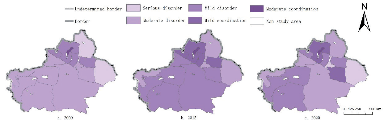
As indicated by the calculation of the coupling coordination degree of the “production-living-ecological” functions of cultivated land (Fig. 6 and Table 4), the overall level of coupling coordination in Xinjiang showed an upward trend during the study period. However, no region achieved a high coordination level. Temporally, the proportions of prefecture-level cities and prefectures with coordinated coupling of the three functions were 7.1%, 28.6%, and 21.4% in 2009, 2015, and 2020, respectively, indicating an overall shift towards coordination. However, a rebound toward disharmony occurred between 2015 and 2020, primarily due to declines in cultivated land production functions in some regions. For example, Urumqi saw a decrease of nearly 4,805 kg/ha in grain yield per hectare, while the output value per mu of cultivated land increased by 200 RMB, reflecting a shift from grain production to cash crop cultivation. Spatially, regions with coordinated coupling were exclusively located in northern Xinjiang, whereas those with disharmonious coupling were primarily found in southern Xinjiang, indicating significant spatial differentiation.
Specifically, in 2009, only Karamay achieved a coordinated level, while Hami and Altay suffered from severe disharmony. By 2015, no region exhibited severe disharmony; south of the Tianshan Mountains, all prefecture-level cities and prefectures except Kizilsu Kirgiz Autonomous Prefecture (moderate disharmony) showed mild disharmony, with 11 regions demonstrating notable improvements in coupling coordination compared to 2009. In 2020, the coupling coordination degree showed distinct spatial differentiation, with northern Xinjiang featuring coordinated clusters centered on Karamay and Tacheng. However, other regions experienced varying degrees of decline compared to 2015. Changji Hui Autonomous Prefecture and Bortala Mongolian Autonomous Prefecture experienced a decline from basic coordination to mild disharmony, while Urumqi and Hami shifted from moderate to severe disharmony. In southern Xinjiang, mild disharmony clustered around the lower Tarim River tributaries (Hotan River, Yarkant River, Kashgar River, and Aksu River basins), including Aksu, Hotan, and Kashgar prefectures.
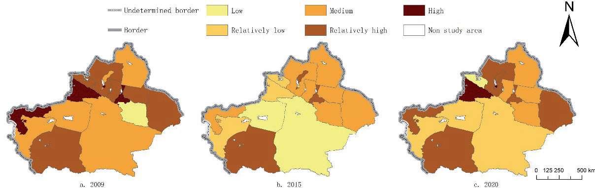
Fig. 6.
Spatial and temporal distribution of coupling and coordination extent of farmland PLE functions.
Consequently, except for Karamay – a unique petroleum-based city – the coupling coordination degree of the three functions in other regions is influenced by natural conditions, particularly water resources, leaving substantial room for improvement in cultivated land use. Nevertheless, with the advancement of agricultural modernization, the expansion of cultivated land, and increasing attention to ecological issues such as soil erosion, the coupling coordination of Xinjiang’s cultivated land encompassing “production-living-ecological” functions is gradually progressing toward harmony.
Spatial Autocorrelation Analysis of Production-Livelihood-Ecological Functions in Cultivated Land Areas
To further explore the spatial differentiation and degree of aggregation in the coupling coordination degree of production-livelihood-ecological functions of cultivated land in Xinjiang, the Moran’s I index was calculated through spatial autocorrelation analysis of the coupling coordination degree of these functions (Table 5). The global Moran’s I indices for the years 2009, 2015, and 2020 were 0.5077, 0.6622, and 0.4830, respectively, all of which passed the 5% significance level. In particular, the index in 2015 passed the 1% significance level, exhibiting spatial aggregation characteristics. By calculating the local Moran’s I index to analyze the aggregation situation of various prefectures and cities during the study period, it was found that in 2009, Altay Prefecture showed a low-high aggregation pattern, Tacheng Prefecture presented a high-high aggregation pattern, and the remaining prefectures and cities showed no significant aggregation characteristics. In 2015, Ili Prefecture, Bortala Mongolian Autonomous Prefecture, and Karamay City transformed from having no aggregation characteristics to exhibiting a high-high aggregation pattern, whereas Altay Prefecture and Tacheng Prefecture maintained their aggregation characteristics as in 2009. In 2020, Ili Prefecture shifted to a low-high aggregation pattern, Bortala Mongolian Autonomous Prefecture changed to having no aggregation, and Turpan City transformed from having no aggregation characteristics to showing a high-low aggregation pattern. In conclusion, the coupling coordination degree of the production-livelihood-ecological functions of cultivated land in Xinjiang shows spatial aggregation characteristics, with the aggregated regions primarily located in northern Xinjiang. With time, the clustering situations of various prefectures and cities have undergone varying degrees of change.
Table 4.
Proportional distribution of coupling and coordination levels of PLE functions of farmland in various states and cities.
Analysis of Driving Factors of the Coupling Coordination for “Production-Living-Ecological” Functions of Cultivated Land
Single-Factor Detection Analysis
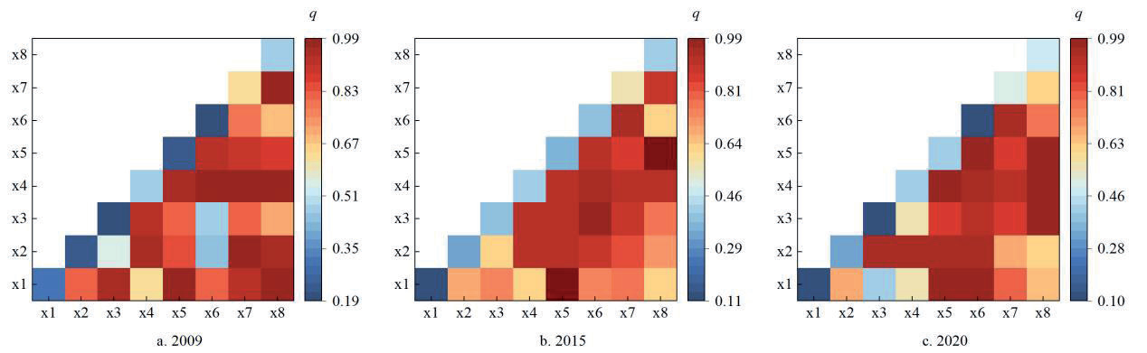
When using the geographical detector to calculate the results corresponding to the single-factor drivers, the closer the q-value is to 1, the stronger the explanatory power. In 2009, the q-values for the driving factors of the coupling coordination degree of the production-livelihood-ecological functions of cultivated land in Xinjiang, ranked from largest to smallest, are X7>X4>X8>X1>X5>X2>X6>X3. Among them, the level of agricultural mechanization (X7), the proportion of the primary industry (X4), and the area of soil erosion control (X8) are the main driving factors. In 2015, the q-values of the driving factors of the coupling coordination degree of the production-livelihood-ecological functions of cultivated land in Xinjiang, ranked from largest to smallest, are X7>X4>X8>X6>X3>X5>X2>X1. The main driving factors are the same as those in 2009, and the explanatory power of the grain sown area (X3) and the proportion of the secondary industry (X6) for the coupling coordination degree of the production-livelihood-ecological functions of cultivated land in Xinjiang has increased. In 2020, the q-values of the driving factors for the coupling coordination degree of the production-livelihood-ecological functions of cultivated land in Xinjiang, ranked from largest to smallest, are X7>X8>X4>X5>X2>X6>X1>X3. The main driving factors are the same as those in 2015. Therefore, it can be concluded that the regional policy level and the level of agricultural development are the main driving factors for the coupling coordination degree of the production-livelihood-ecological functions of cultivated land in Xinjiang. This is mainly due to the unique characteristics of agriculture in Xinjiang’s arid regions, which feature a relatively high degree of large-scale agriculture, and all regions attach great importance to agricultural production. In contrast, the explanatory power of the urbanization level and the level of industrial development is relatively weak. For example, in 2020, the urbanization rate in Karamay City, located in northern Xinjiang, was 99.59%, whereas that in Hotan Prefecture in southern Xinjiang was only 19.67%. The huge north-south differences lead to a decrease in the explanatory power of urbanization levels for the coupling coordination degree of the production-livelihood-ecological functions of cultivated land in Xinjiang. Moreover, the q-values vary in different years, mainly due to factors such as fluctuations in agricultural product prices over time and the dynamic adjustments of regional policies.
Interactive Factor Detection Analysis
Based on the interpretation of the influence of single factors on the coupling coordination degree of the production-livelihood-ecological functions of cultivated land in Xinjiang, the detection results of interactive factors were further analyzed. The research results show that the interaction relationships among various factors are characterized by dual-factor enhancement and nonlinear enhancement. This indicates that the coupling coordination degree of the production-livelihood-ecological functions of cultivated land in Xinjiang is driven by interactive factors, and compared with single factors, dual factors have a stronger driving effect on it. As shown in Fig. 7, during the study period, the interactive driving force between the area of soil erosion control (X8), the proportion of the urban population (X1), the proportion of the primary industry (X4), the level of agricultural mechanization (X7), and other factors has increased over time, while the interaction between the proportion of the secondary industry (X6), the proportion of grain sown area (X3), the proportion of urban land use (X2), and other factors has weakened over time. Overall, the regional policy level, agricultural development, and industrial development are the primary driving factors. That is, with an emphasis on the ecological protection of cultivated land in various prefectures and cities, as well as the popularization of agricultural modernization, the comprehensive utilization level of local cultivated land resources has been enhanced. Combined with the results of single-factor detection, it further illustrates that the regional policy level plays a dominant role in driving the coupling coordination degree of the production-livelihood-ecological functions of cultivated land in Xinjiang. At the same time, it also interacts with the level of agricultural development and urbanization, having a positive effect on the coupling coordination degree of the production-livelihood-ecological functions of cultivated land in Xinjiang. Therefore, when carrying out agricultural production, various prefectures and cities in Xinjiang should strive to enhance the effective utilization of water resources, prevent the mismatch between the scale of agricultural production and cultivated land resources caused by the large-scale expansion of cultivated land, reduce the phenomenon of cultivated land abandonment, promote and publicize agricultural machinery and equipment, encourage and subsidize the use of modern agricultural equipment for agricultural production, and promote the high coordination of the production, livelihood, and ecological functions of cultivated land in Xinjiang.
Fig. 7.
The results of the interaction driving factor detection of the coupling coordination extent of PLE functions of farmland in Xinjiang.
Under the strategic background of cultivated land protection and food security, cultivated land is playing an increasingly important role in land resources. Xinjiang is rich in land resources, and the distribution of cultivated land within the region is relatively extensive. From a national perspective, Xinjiang has a large amount of strategic reserve cultivated land, which can, to a certain extent, serve as a supplement for the reduction of cultivated land resources in China’s coastal areas. Regarding the cultivated land in Xinjiang, numerous studies have been conducted to calculate the quantity of cultivated land and assess its quality; however, there is a lack of in-depth discussion on the diversified utilization of cultivated land resources.
This study takes the grain production capacity of the cultivated land system, the livelihood security function of rural residents, and the ecological impact effect as the research basis, systematically deconstructs the theoretical connotation of the production-livelihood-ecological functions of cultivated land, constructs a comprehensive evaluation system, and reveals the driving factors for the coordinated development among various functions. The research results show that the spatial distribution of the coupling coordination degree among the production-livelihood-ecological functions of cultivated land in Xinjiang has undergone significant changes between 2009 and 2020. The coordinated regions show an overall increasing trend, which is mainly driven by regional policy levels and agricultural development, reflecting the local government’s emphasis on agricultural modernization and its attention to the ecological protection of cultivated land.
This paper evaluates the production function of cultivated land in Xinjiang from the perspective of food security, without considering the production of economic crops such as cotton and fruits. At the same time, when identifying the driving factors for the coupling coordination degree of the production-livelihood-ecological functions of cultivated land in Xinjiang, each driving factor is only set as a fixed index, without considering the dynamic changes of these factors in reality. Therefore, in the future, it will be necessary to conduct an in-depth analysis of the above-mentioned deficiencies. In addition, the study finds that the distribution of the coupling coordination degree of the production-livelihood-ecological functions of cultivated land in Xinjiang is partially consistent with the richness of natural resources. For example, the water resources in northern Xinjiang are relatively more abundant than those in southern Xinjiang, and the production-livelihood-ecological function index and the coupling coordination degree of cultivated land are also generally higher than those in southern Xinjiang [23]. This phenomenon indicates that natural conditions, such as water resources, are closely linked to the coordinated development of multifunctional cultivated land, which can serve as an important direction for subsequent research.
Conclusions
This paper takes the 14 prefectures and cities in Xinjiang Uygur Autonomous Region as the research area, establishes an evaluation system for the production-livelihood-ecological functions of cultivated land in Xinjiang, calculates the coupling coordination degree among the production, livelihood and ecological functions of each prefecture and city, explores the spatio-temporal evolution law of the production-livelihood-ecological functions of cultivated land in Xinjiang through visualization mapping and spatial autocorrelation models, constructs an index system of driving factors, and uses a geographical detector to explore the driving factors of the coupling coordination degree of the production-livelihood-ecological functions of cultivated land in Xinjiang. The research conclusions are as follows:
(1) During the study period, the production and livelihood functions of cultivated land in Xinjiang showed an upward trend, while the ecological function showed a downward trend. From 2009 to 2015, the production and livelihood functions of cultivated land in Xinjiang showed an upward trend, and the ecological function showed a downward trend. The production and livelihood functions in northern Xinjiang were significantly better than those in southern Xinjiang. From 2015 to 2020, the production and livelihood functions of cultivated land in Xinjiang showed a downward trend, and the ecological function showed an upward trend. Moreover, the differences in the production and livelihood functions of cultivated land between northern and southern Xinjiang have become more pronounced.
(2) During the study period, the coupling coordination degree of the production-livelihood-ecological functions of cultivated land in Xinjiang showed an overall upward trend, but there were no regions with a high degree of coordination. From 2009 to 2015, the coupling coordination degree among production-livelihood-ecological functions of cultivated land showed an upward trend. Most prefectures and cities changed from moderate disorder to mild disorder, and regions with a coupling coordination degree above the general level were primarily distributed in northern Xinjiang. From 2015 to 2020, the coupling coordination degree of the production-livelihood-ecological functions of cultivated land showed a downward trend, and the coupling coordination degree of the production-livelihood-ecological functions of cultivated land in each prefecture and city was mainly in the intervals of mild disorder and moderate disorder.
(3) During the study period, the production-livelihood-ecological functions of cultivated land in Xinjiang showed significant spatial aggregation characteristics. From 2009 to 2015, the spatial aggregation degree of the coupling coordination degree of the production-livelihood-ecological functions of cultivated land increased, presenting a characteristic of single-center aggregation distribution. From 2015 to 2020, the coupling coordination degree of the production-livelihood-ecological functions of cultivated land showed spatial differentiation characteristics, presenting multi-center aggregation distribution with Karamay City in northern Xinjiang and Turpan City as the primary centers, and Aksu Prefecture, Kashgar Prefecture, and Hotan Prefecture in southern Xinjiang as the secondary centers.
(4) During the study period, the coupling coordination degree of the production-livelihood-ecological functions of cultivated land in Xinjiang was mainly affected by the regional policy level, the level of agricultural development, and the level of industrial development. However, different factors have different explanatory powers for the changes in the coupling coordination degree, and the level of urbanization has a relatively small impact on the coupling coordination degree of the production-livelihood-ecological functions of cultivated land in Xinjiang. The interaction types among the driving factors are all dual-factor enhancement or nonlinear enhancement, and there is a trend of transformation from the dual-factor enhancement type to the nonlinear enhancement type, indicating that the driving factors of the coupling coordination degree of the production-livelihood-ecological functions of cultivated land in Xinjiang are evolving towards the direction of multi-factor interactive driving.
Based on the calculation results of the coupling coordination degree of the production-livelihood-ecological functions of cultivated land, combined with its driving factors and the locational resource endowments of different prefectures and cities, the following suggestions are proposed:
(1) In terms of coordinated regions, in 2020, all prefectures and cities where the coupling coordination degree of the production-livelihood-ecological functions of cultivated land was at the coordinated level were located in northern Xinjiang, namely Karamay City, Tacheng Prefecture, and Turpan City. As the only region at the intermediate coordination level, Karamay City has a relatively developed non-agricultural economy and a high level of urbanization, resulting in a small rural population and a high per capita cultivated land area. Therefore, it is necessary to enhance the level of agricultural mechanization to assist the small rural population in engaging in cultivated land production. Additionally, adjusting the planting structure by selecting market-suitable and higher-value crops can further enhance the production and livelihood capabilities of cultivated land. At the same time, it is crucial to be vigilant about the environmental load caused by the increase in cultivated land production capacity. This can be achieved by increasing the area of water-saving irrigation and selecting degradable mulch films to enhance the ecological function of cultivated land.
For Tacheng Prefecture and Turpan City, which are at the basic coordination level, the former should focus on the constraint of the low land-average output value of cultivated land on the livelihood function. Under the premise of ensuring the regional grain supply capacity, selecting crops with higher agricultural added value can enhance the livelihood function of cultivated land. The latter, due to its location in the Turpan Basin, has a hot climate and strong soil moisture transpiration, resulting in high agricultural water consumption, which significantly impacts the ecological function of cultivated land. It is necessary to increase the popularization of water-saving irrigation methods such as drip irrigation and select more drought-resistant and water-saving crops to improve the coordination level of the production-livelihood-ecological functions of cultivated land.
(2) In terms of disordered regions, Urumqi City and Hami City are at the severe disorder level, and both have a low proportion of the primary industry. As the provincial capital, Urumqi has a limited grain planting area. It is necessary to improve grain yield per unit area by enhancing the level of mechanization and modernization, thereby enhancing the cultivated land’s ability to guarantee rural residents’ employment, food supply, and economic income. Additionally, it is essential to strictly implement the cultivated land compensation policy in urban fringe areas to ensure the maintenance of the cultivated land area red line.
Hami City, located in the Hami Basin, is restricted by factors such as a low land reclamation rate, resulting in a low per capita cultivated land area and grain possession, which leads to low production and livelihood functions of cultivated land. Under the premise of maintaining the ecological function of cultivated land, it can be appropriately expanded by reclaiming abandoned cultivated land and introducing saline-alkali land treatment technologies, thereby increasing grain production, boosting agricultural output value, and improving the disordered situation.
For other prefectures and cities at the mild and severe disorder levels, special attention should be paid to the ecology of cultivated land in these areas. For regions with weak ecological functions of cultivated land, adjustments to existing farming schemes should be made. In areas with limited water resources, the existing cultivated land area and planting scale should be maintained as much as possible. In areas with extremely scarce water resources, the exploitation of groundwater resources should be strictly restricted, and attempts should be made to develop water-saving agriculture or implement the “returning cultivated land to water” policy.
For counties and cities with high ecological functions of cultivated land but low production and livelihood functions, which are usually located in areas where large-scale agricultural production is difficult, it is advisable to consider the local geographical conditions, moderately develop agriculture in areas with relatively abundant water resources and flat terrain, formulate scientific and strict cultivated land protection measures, plan to plant fruit trees and forest trees on hillsides as much as possible, and reserve high-quality cultivated land for grain crops. For the above-mentioned areas, unreasonable patterns of cultivated land utilization should be regularly investigated and discouraged through education. The promotion of environmentally friendly agricultural chemical inputs should be implemented, and locally appropriate cultivated land protection measures should be strictly enforced to promote the coordinated development of the production-livelihood-ecological functions of cultivated land.

