

Introduction
Land is the basic spatial carrier for the survival and development of human society. As the global socio-economic environment continues to change and the population grows, human demand for land-derived goods and services continues to grow. The functional dimensions of land gradually expand from a single production function to a multi-dimensional spectrum covering economic, social, and ecological functions, and the intensity of human development and utilization of land resources also gradually increases. However, due to the scarcity and uneven distribution of land resources, the contradiction between limited land resources and high-intensity, multifunctional land use has become increasingly prominent. In this context, how to achieve the coupling and coordination of multifunctional land use has become a key focus and challenge for achieving regional sustainable development and optimizing territorial spatial planning.
Research on multifunctional land use has been one of the hot topics in the field of sustainable land development in recent years. Research on multifunctional land use first originated from agricultural systems [1] and has since gradually expanded to the multifunctional aspects of ecosystem services and land use [2-3]. Existing research mainly focuses on the identification and assessment of land use functions. Scholars construct land use function evaluation index systems [4] from economic, social, and environmental perspectives according to the specific problems and research objectives of a region and quantitatively measure land sub-functions using methods such as economic models [5], ecological models [6], and empirical models [7]. With the impact of economic development and rapid urbanization on the ecological environment, optimizing and adjusting the production, living, and ecological (PLE) functions of land has gradually become an important principle in drafting current spatial planning and sustainable development strategies [8].
The core of territorial spatial planning is the accurate prediction of future spatial scales and quality requirements [9], and effective planning in turn depends largely on finer-scale information. As the most basic administrative unit in China, the county is the smallest unit for land planning and management, and taking the county as the research unit can better capture the spatial heterogeneity of land multifunctionality, enabling more specific and accurate guidance for land use management. Therefore, based on the development strategy needs of Fujian Province, this study takes the county as the research object, constructs a county-level land use function evaluation index system based on the “production-living-ecology” (PLE) functional perspective, determines the weights of the indicators using the entropy method, and quantitatively evaluates the spatial and temporal change characteristics of land use functions in Fujian Province from 2014 to 2022. Secondly, a coupling coordination model is established to calculate the coupling coordination degree of the three major PLE functions in Fujian Province. According to the coordination degree, combined with spatial clustering analysis, the results are classified into five grades: barely coordinated, elementary coordinated, intermediate coordinated, good coordinated, and high-quality coordinated. Finally, this study fully considers the spatial heterogeneity of influencing factors and uses a geographically weighted random forest model to identify the factors affecting the coordination degree of PLE function coupling. The results of the study help to further optimize the spatial layout of PLE functions of land in Fujian Province, provide a scientific basis and support for future land planning in Fujian Province, promote local sustainable development, and provide a reference for territorial spatial planning in other regions.
Theoretical Analysis
Research on “production-living-ecology” (PLE) originated from the Multifunctional Classification System of the European Union [10]. Subsequently, related studies developed rapidly and were widely applied in scenario prediction [11], landscape planning, and land use research [12]. Based on the concept of sustainable development, Chinese scholars focus on the “production-living-ecology” (PLE) perspective according to land’s three main functions [13]. Current research on land PLE functions primarily addresses measurement, assessment, and spatiotemporal evolution [14-17]. Scholars developed a framework for classifying and assessing PLE functions [18] and evaluating land use functions using the entropy method [19], the analytic hierarchy process [20], and other weighting methods. Further studies depicted changes in production, living, and ecological spaces in specific regions, finding that their dynamic evolution is mainly influenced by rapid agricultural growth, economic development, population dynamics, and policies [21]. Notably, some living space expansion occurs at the expense of production and ecological spaces [22-23], reflecting inherent conflicts between land use functions [24-25]. Regarding spatial scales, research covers global [26], national [27], provincial [28], urban agglomeration [29], municipal [30], county-level [31], and natural regions such as watersheds [32], plains [33], and plateaus [34]. However, studies focusing on Fujian Province, a typical region with both a high-quality ecological environment and advanced economic development, remain relatively scarce.
Land’s production, living, and ecological functions are interconnected. With accelerated urbanization and rural hollowing, inefficient land use and functional conflicts coexist, prompting exploration of paths toward multifunctional coordination. Coupling coordination analysis effectively measures systemic multifunctionality relationships. Coupling, as a physics concept, denotes interactions between system components [35], while “coordination” refers to synergistic effects. The coupled coordination model quantifies subsystem interactions, revealing interdependencies and supporting system optimization. It shows particular utility in assessing complex ecological-economic-social interactions.
PLE coordination is crucial for balancing regional spatial structures and ensuring stable development. Current research emphasizes evaluating and measuring PLE coupling coordination [36]. Scholars attribute its evolution to the combined effects of natural endowments, socio-economic factors, and policies [37]. For example, Zhang [38] found higher ecological functions in key ecological zones, yet lower overall PLE coordination due to factors like economic development, social security, and environmental conditions.
Table 1.
Data sources and description.
Conversely, studies on drivers of coupling coordination are limited, predominantly using traditional econometric regression, kernel density estimation, and spatial autocorrelation [39-41]. Geographically weighted random forests (GWRF) overcome these limitations by revealing nonlinear relationships, capturing spatial heterogeneity, and assessing variable importance. By constructing local random forests at each observation point and using feature importance, GWRF enhances explanatory power. This study thus constructs a PLE multifunctional land use index system, applies a coupling coordination model to quantify subsystem coordination levels, evaluates the spatiotemporal evolution of PLE functions and coordination, and adopts GWRF to identify influencing factors and their relative importance.
Material and Methods
Data Sources
Study Area
Fujian Province (E115°50’~120°43’, N23°31’ ~28°18’), abbreviated as Min, is located on the southeast coast of China. It administers nine prefecture-level cities (Fuzhou, Xiamen, Zhangzhou, Quanzhou, Sanming, Putian, Nanping, Longyan, and Ningde) and the Pingtan Comprehensive Experimental Zone. In total, the province comprises 11 county-level cities, 31 municipal districts, and 42 counties (including Kinmen County). Fujian Province has a land area of 124,000 square kilometers. The province has a complex terrain; the terrain of the province is mainly mountainous and hilly, with mountains and hills accounting for about 90% of the total area of the province, river valleys and basins in the central and western parts of the province, and hills and coastal plains along the eastern coast, with the terrain in general being high in the northwest and low in the southeast and presenting a mountainous and seaward situation.
As a national ecological civilization pilot area, an important area for opening up to the outside world, and the core area of the 21st Century Maritime Silk Road, Fujian Province has undergone a profound reconstruction of human-land relations and regional development patterns. Its unique location advantages and strategic value make the region face unprecedented opportunities and challenges in the optimization of land space and sustainable development. Northwestern mountainous areas experience significant outmigration of working-age populations, leading to rural hollowing, intensified farmland abandonment, and inefficient land use. Conversely, southeastern coastal areas face slowed industrial transformation and encroachment on ecological spaces. Therefore, this study examines Fujian Province, collecting county-level data to systematically analyze spatiotemporal evolution patterns of land use functions (production-living-ecology) at the county scale. This approach holds critical practical value for optimizing local territorial spatial governance systems.
Data Sources
The data sources and descriptions used in this study are presented in Table 1, including land use data and relevant socio-economic data for Fujian Province across three periods (2014, 2017, and 2022). Considering data availability, this study uses county administrative units as the basic research unit to calculate values for each secondary land use function indicator. Due to serious data gaps, however, information from Sanyuan District (Sanming City) and Kinmen County (Quanzhou City) was excluded.
Land Use Function Evaluation Index System
The coordinated development of production-living-ecological (PLE) spaces influences ecosystem dynamics and human societal progress. Thus, in-depth analysis of PLE functions is essential for exploring coordinated spatial utilization [43].
Production function is the basic function of land, which refers to the function of land as a labor object to directly acquire or use land as a carrier for social production to produce various products and services [44-45]. Agricultural production occupies ecological space, consumes resources, and provides essential livelihood products. While cultivation and livestock rearing represent direct agricultural methods [46], Fujian’s coastal geography gives prominence to aquatic products in its agricultural supply. Hence, this study measures the land production function via agricultural output levels, grain production, vegetable production, meat production, and aquatic product yield [47-49].
Living function refers to the ability of the land use system to satisfy the living needs and life security of residents, the core of which lies in convenience services and livability [50], covering residence, consumption, leisure and entertainment, medical care, and education. Therefore, according to the attributes and types of public services provided, the article selects the average road mileage, the number of beds per 10,000 people, and the ratio of primary and secondary school teachers to students as indicators from the perspectives of transport, healthcare, and education [51-52]. In addition, per capita gross regional product is a key indicator for measuring economic prosperity and living standards, and urbanization rate is an important indicator for measuring the level of urbanization development. Therefore, GDP per capita and urbanization rate are also included in the indicator system when measuring the living function of land [53-54].
Ecological function refers to the ability of land to maintain the stability of the ecosystem of the rural system as well as to provide ecological services and material information [55], which is a natural condition to support human beings to carry out high-quality production and living. However, it cannot directly provide material output, but provides a good guarantee for human production and livelihood [56]. In order to better measure the level of ecological function, the article selects vegetation cover and water cover [57- 58] as ecological maintenance indicators and slope as ecological load indicators [59] from the perspective of ecological maintenance and ecological load. The higher the vegetation cover and water cover, the more stable the ecological environment and the stronger the ecological carrying capacity. And the larger the slope index is, the more unfavorable the ecological dimension is, which will cause disturbance to the ecological environment.
Research Methods
Functional Evaluation Model
Based on the principles of representativeness, comprehensiveness, and availability, the study constructs the land use function evaluation index system (Table 2) by referring to the existing research results [60] and combining them with the actual situation of the relevant counties in Fujian Province. In the measurement method of indicator weights, this study chooses the entropy value method. The entropy value method is a measurement method based on information entropy, which judges the discrete degree of each indicator according to the entropy value size of each indicator, which can maximally eliminate the uncertainty in the evaluation and analysis. The entropy value method is more objective compared with the hierarchical analysis method and the principal component analysis method. The specific calculation steps are as follows:
First of all, in order to eliminate the influence of the indicators due to the inconsistency of the scale, all indicators should be normalized before measurement. For forward and reverse indicators, the normalization formula is different. For positive indicators:
For the reverse indicator:
Where xij denotes the value of i th sample on the jth indicator.
In the second step, the entropy value of the jth indicator is calculated ej.
In the third step, the weight of the indicator j is calculated wj.
Where n indicates the number of indicators.
In the fourth step, the weights of the measured indicators are used to measure the scores of the indicators in the previous level Sr, where r indicates the number of indicators in the previous level.
Table 2.
Indicator system for measuring county PLE functions in Fujian Province.
Where
Coupling Coordination Model
The essence of multifunctional land use planning and management lies in realizing the balance of the three functions of production, living, and ecology to achieve the maximum comprehensive benefit. The degree of coupling coordination refers to the process of interaction and coordination among multiple different systems, which can be used to reflect the degree of coordination among multifunctional land use functions in the utilization process. Therefore, combining with the actual situation of the study area, the article introduces the coupling coordination degree model to reflect the coordination level of the interaction between production, living, and ecology of land use [61-62], and the formula is as follows:
In Eq. (6) to Eq. (8), C denotes the degree of coupling; F1, F2, and F3 denote the evaluation indices of production function, living function, and ecological function of land use, respectively; T denotes the comprehensive coordination index of land use functions; α, β, and γ are the pending weights of each sub-function, respectively. For Fujian, improving the level of socio-economic development and the living standard of the inhabitants and maintaining ecological harmony are equally important in urban development, so this study takes α = β = γ = 1/3. According to the existing research and calculation results [63], using the equal spacing classification method, with 0.15, 0.25, 0.35, 0.45, and 0.55 as the breakpoints, the type of coupled coordination of the PLE functions of counties in Fujian Province is classified into five categories: slightly coordinated, elementary coordinated, moderately coordinated, favorably coordinated, and high-quality coordinated.
Geographically Weighted Random Forest (GWRF)
The traditional Random Forest (RF) algorithm shows high applicability in measuring impact factors but ignores the spatial non-stationarity of the variables [64]. The Geographically Weighted Random Forest (GWRF) model is based on the local modeling idea of geographically weighted regression (GWR) and extends RF by incorporating spatial dependence to take into account the spatial heterogeneity of the variables themselves [65], which can effectively address the limitations of the global model in spatial heterogeneity analysis. The GWRF model in this study is mainly implemented by “SpatialML” in R. The expression of the GWRF model is as follows:
In Eq. (9), Yi is the value of the dependent variable for the first observation at i, α(ui,vi)xi is the prediction of the RF model calibrated at i, e is the model error, and (ui,vi) is the coordinate.
In this study, based on the characteristics of the factors affecting the function of land use, eight influencing factors are selected from two dimensions [66- 67], natural geographical conditions and socio-economic characteristics, to be analyzed. Among them, the natural geographic conditions represent the endowment of land use, which determines the breadth and depth of the PLE functions, while the socio-economic characteristics represent the way and demand of human beings for land use, which will also have an important impact on land use. This study refers to relevant research results, taking into account the accessibility of county-scale data, and selects representative and different indicators to quantitatively analyze the impact of multifunctional land use. The selection of specific factors is shown in Table 3. The study uses each functional index as Y and adopts a geographically weighted random forest to measure each influence factor.
Results
Spatial and Temporal Evolution of Land PLE Functions
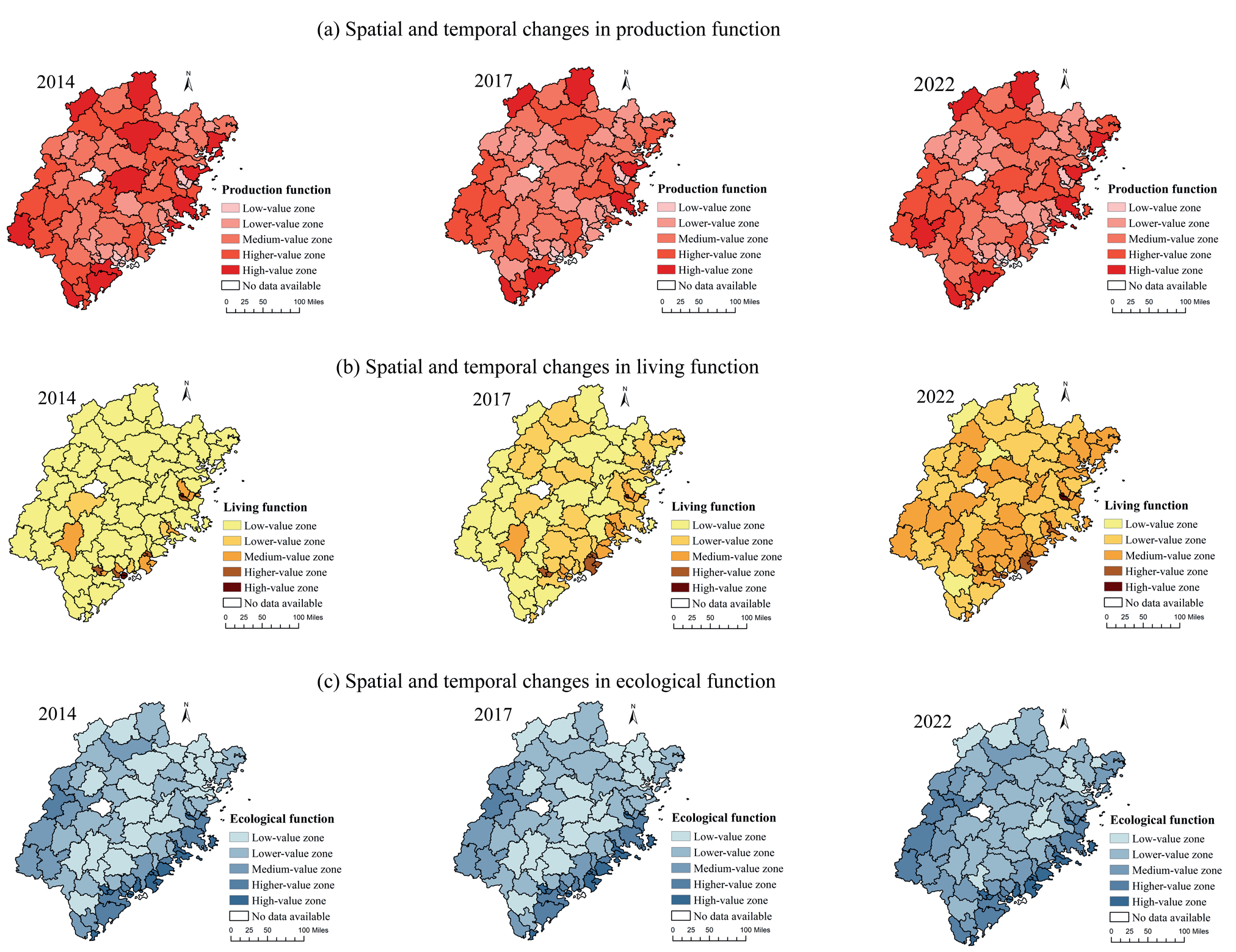
Based on the PLE evaluation index system, we calculated the production, living, and ecological function values for each county in Fujian Province (2014, 2017, 2022). In order to further clarify the land use situation in Fujian Province, this study is based on ArcGIS 10.8 (Fig. 1). It applies the natural breakpoint method to divide the multifunctionality of the counties into five hierarchical zones (slightly coordinated, elementary coordinated, moderately coordinated, favorably coordinated, and high-quality coordinated) and spatially visualize the production function, living function, and ecological function hierarchical zones of the counties.
Production Function
From 2014-2022, the overall land production function in Fujian Province shows a decreasing trend, with high production value areas mainly concentrated in Glossy County, Pucheng County, and Jian’ou City in Nanping City, Wuping County and Shanghang County in Longyan City, and Xiapu County and Fuding City in Ningde City. In contrast, the low production value areas are mainly distributed in Xiang’an, Haicang, and Luogang districts and counties in southern Fujian Province. The reason for this abnormal spatial distribution is mainly the dual role of natural conditions and socio-economics. The plains of Fujian Province are mainly distributed in the southeastern coastal area, and the superior harbor conditions make the local aquatic products more productive. Hence, the southeastern coastal area has a stronger agricultural production function. However, in the Xiamen-Zhangquan metropolitan area, represented by Xiamen, the local agricultural production function has gradually weakened as the arable land resources in the area have been heavily occupied by construction land in the context of the accelerating urbanization process. Nanping and Longyan, located in western and northern Fujian, are situated in mountainous areas but have a long history of agricultural cultivation, making them important tea and rice production areas. Through the path of “eco-industrialization”, the value of the production function of the revaluation of the land has been further strengthened by the agricultural production function. Fuding City and Xiapu County in Ningde City have a long coastline and many islands, and have developed seawater aquaculture and fishing industries.
Living Function
From 2014 to 2022, the production and living functions of land in Fujian Province will show an obvious upward trend, with a gradient distribution characteristic of “coastal high, inland low” in the spatial distribution. The high-value area is concentrated in the Xiamen-Zhangzhou-Quanzhou metropolitan area, which has a strong capacity for infrastructure investment and public service provision due to the continuous policy tilt through the “Southwest Fujian Cooperative Development Zone” and other strategies, as well as the “Maritime Silk Road”. The hub status of the “Maritime Silk Road” continues to attract high-end talents, business capital, and other factors, which further strengthen the local living function. Low-value areas are mainly distributed in the less developed counties in western and northern Fujian, where the local infrastructure network construction costs are high, public services have obvious shortcomings, and the living function is weaker due to the impact of local terrain fragmentation and poor natural endowment. In terms of dynamic changes, the scope of the median area is gradually expanding, but the gap between inland counties and cities and the coast is still relatively obvious.
Ecological Function
The spatial differentiation of land ecological functions in Fujian Province during 2014-2022 is significant, with high-value zones distributed in coastal areas such as Dongshan County, Zhangpu County, and Jinjiang City, as well as in districts and counties such as Jianyang County, Jianning County, Ninghua County, Changting County, and Wuping County, which are to the east of Wuyi Mountain. Among them, the coastal counties represented by Dongshan and Zhangpu have built a resilient ecological network through mangrove restoration and marine protected areas. The mountainous counties in the Wuyi Mountain Range region, represented by Jianyang, have formed habitats for rare species and ecological product supply bases through ecological policy support, including the Wuyi Mountain Nature Reserve, the construction of national parks, and the soil erosion remediation project. The overall ecological environment of these counties is excellent, and the land ecological function index is high. Low-value areas are scattered in Yongtai, Minqing, Anxi, Hua’an, and other inland transition zone counties. In the dynamic distribution of land ecological function, the overall land use ecological function in Fujian Province shows a rising trend.
Table 3.
Indicator System for Measuring Rural Functions in County Areas of Fujian Province.
Cold Hotspot Analysis of PLE Functions
The study calculated the Moran index of the land use function index of Fujian Province. As shown in Table 4, the Moran indices of production function, living function, and ecological function are [0.177,0.273], [0.386,0.487], and [0.575,0.576], respectively, indicating that the spatial agglomeration of the three types of functions is higher and the layout is more concentrated. Overall, the ecological function has the highest degree of concentration, followed by the living function and finally the production function.
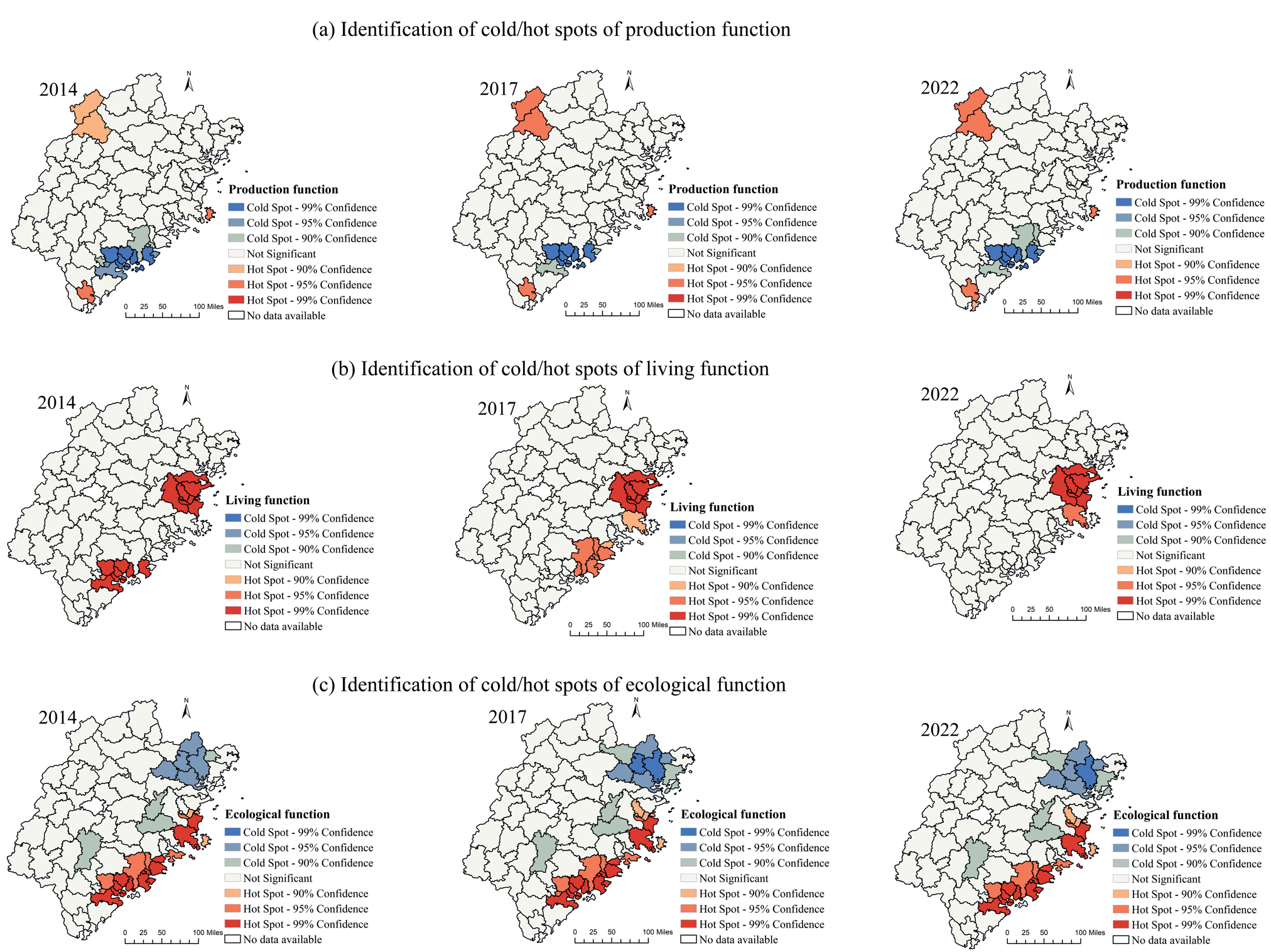
In this study, the hotspot analysis tool of the Getis-Ord Gi* statistical index was used to analyze the distribution of cold and hot spots of production, living, and ecological functions in Fujian Province, and the distribution maps are shown in Fig 2. Hot spots (red) indicate low-value aggregation areas (z>+1.65), i.e., the spatial function index is significantly higher than the surrounding areas; cold spots (blue) indicate high-value aggregation areas (z<-1.65), and the table spatial function index is significantly lower than the surrounding areas. The cold and hot spot areas reflect the spatial imbalance of supply and demand or resource agglomeration characteristics of the PLE functions.
During 2014-2022, the distribution of cold hotspots of production functions of land in Fujian Province was relatively stable. There are three main hotspot areas for the production function, the first being the districts and counties of Glossy, Shaowu, and Shaxian, which are located in the northern part of Fujian. The area presents a low mountainous landscape characterized by hilly and mountainous terrain, with abundant year-round rainfall and a temperate and humid climate, making it the main grain-producing area in the province. The locality has upgraded traditional rice farming to a production system covering organic cultivation, relying on the mountainous climate and branding effect to promote agricultural development. It is one of the important agricultural production areas in Fujian Province. Another notable hotspot is the Fuzhou Coastal District and County in eastern Fujian, which is located in the coastal area, relying on the advantages of aquatic products agglomeration, building the whole industry chain of ocean fishing, cold chain, deep processing, and trading and logistics, and forming a regionally recognizable agricultural production model. The third hotspot area is Pinghe, Yunxiao, Dongshan, Longhai, and other districts and counties located in the southern region of Fujian. The region is also a famous agricultural county in Fujian Province, which mainly cultivates special agricultural industries such as Pinghe Gwenxi honey pomelo, Baiya Qilan tea, vegetables, Banzai bananas, and qingmei plums. Local activities such as honey pomelo festivals and tea king competitions are organized to improve the quality grade and popularity of agricultural products, which in turn enhances economic benefits. Cold spot areas for production functions are mainly concentrated in the Xiamen-Zhangquan metropolitan area. Against the background of rapid urbanization and economic restructuring, the metropolitan area is undergoing a profound change from a “manufacturing-led” to a “service economy-led” economy, and traditional industrial counties such as Jinjiang and Shishi are restructuring and transforming their industries, so the local production function is gradually weakening. As a result, the local production function is gradually weakening. During the period 2014-2022, Longhai District has gradually changed from a hotspot of production function to a coldspot area, also due to the impact of the urbanization trend. In 2021, Longhai District, following the administrative division adjustment of withdrawing the city and setting up a district, will focus on and integrate into the goal of Xiamen-Zhangzhou crosstown development. In this context, its original agricultural production function is further weakened.
There are two main hotspots for the living function: one is the eastern part of Fujian with Fuzhou at its core, and the other is the southern part of Fujian with Quanzhou and Xiamen at its core, with the core driving force stemming from the synergy of local public finance and policy support. The living function of land in Fujian Province is relatively balanced, with no obvious low-value agglomeration areas, mainly stemming from the high investment funds in infrastructure construction and public services in Fujian Province, and there are no significant cold spots for the living function in the relatively underdeveloped regions of western Fujian and northern Fujian.
The hotspots of ecological functions are mainly concentrated in the coastal towns of eastern Fujian and southern Fujian, with Fuzhou, Putian, Quanzhou, Xiamen, and Zhangzhou as the core, which mainly manage and repair the ecological space in a refined way through a combination of natural restoration and artificial intervention and actively promote the green transformation of industries, which plays an important role in maintaining the integrity of the ecosystem and protecting the ecological environment and biodiversity, and thus becoming the core area of the hotspots of ecological functions. They have played an important role in maintaining the integrity of the ecosystem, protecting the ecological environment and biodiversity, and thus becoming the core areas of the ecological function hotspots. The cold spots of ecological function are mainly concentrated in Fu’an, Shouning, and Zhouning, which are located in the mountainous areas of northern Fujian. Because of their location in the mountainous areas, natural disasters such as landslides and soil erosion are frequent. Alongside this, the industrial structure of the local agricultural production, the traditional use of pesticides and fertilizers, is still used in the process of agricultural production in order to increase the yield, which has further aggravated the damage to the ecological environment.
PLE Functions Coupling Coordination Analysis
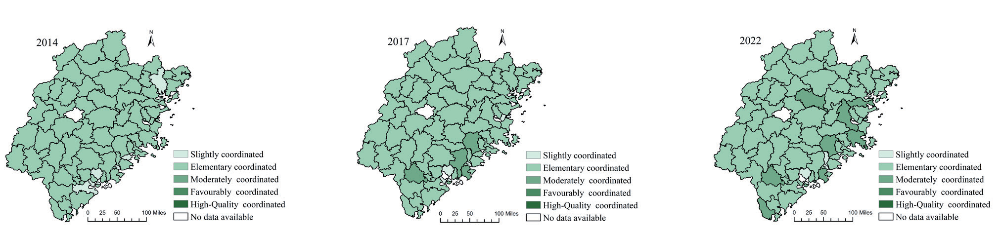
For further clarification, this study calculates the multifunctional coupled coordination degree of counties in 2014, 2017, and 2020 using the coupled coordination degree model based on the results of land use evaluation in counties in Fujian Province. As shown in Fig. 3, the functional coupling coordination of land use in Fujian Province has improved considerably since 2014-2022, but it is still dominated by elementary coordination. With the comprehensive construction of the national ecological civilization pilot zone and the emphasis and popularization of the concept of ecological civilization, the overall coupling and coordination level of Fujian Province has significantly improved, and the number of intermediate coordinated zones has significantly increased. In 2022, under the double constraints of China’s “double carbon” target and national spatial planning, the coupling and coordination level of Fujian Province will be significantly improved. In 2022, under the double constraints of China’s “dual carbon” target and national spatial planning, the number of intermediate coordinated zones in Fujian Province will increase dramatically and show a trend of gradually spreading from coastal areas to inland areas.
The Influence Mechanism of PLE Functions on Coordination Degrees
The coupled coordination degree of PLE functions in Fujian Province is affected by multiple factors, and the analysis mainly focuses on the natural geographical conditions and socio-economic characteristics.
From the perspective of the overall change in the importance of each influencing factor (Fig. 4), the indicators selected for the natural geographical conditions are all relatively stable, so the high and low value areas of the degree of influence in the spatial and temporal distribution pattern as a whole show relatively stable characteristic. Jin'an District is one of the four PLE functionally coupled high-value coordination zones in terms of elevation (X1), relief (X2), precipitation (X3), and distance from prefecture-level cities (X4). The topography of Jin'an District is characterized by a distribution pattern that is high in the northeast and low in the southwest. The area features the third branch of Wufeng Mountain in the northeast, low hills scattered in the northern mountains, and a large plain in the south. Therefore, topographic conditions such as elevation (X1) and relief (X2) form more obvious constraints on local land use patterns. At the same time, the blocking effect of the northeastern mountains, coupled with the limited water storage capacity of the rivers and the large plains in the south as built-up areas carrying a large number of mass populations, makes precipitation (X3) a key factor affecting the local PLE coordination. In addition, because of its proximity to Fuzhou City (X4), Jin'an District is subject to the impacts of the metropolitan area's development and expansion while acquiring resources and policy support.
Another high-value area in the southeastern coastal region of Fujian Province is clustered around the Xiamen-Zhangzhou-Quanzhou area. Mountainous, hilly, and terraced landscapes dominate Xiang'an and Huli districts in Xiamen City. Thus, natural geographic conditions such as elevation (X1) and relief (X2) also profoundly affect the coordination of local PLE functions. As the core areas of the Xiamen-Zhangquan metropolitan area, the two districts are closer to the prefecture-level city centers (X4). They are strongly radiated by the metropolitan area, coupled with a developed economy, dense population, high water demand, and a high degree of dependence on precipitation (X3). Longhai District in Zhangzhou City is located in the lower alluvial plain of the Jiulong River. Mountains on the north, west, and south surround the terrain. The unique topography makes it easy for the local area to form a precipitation center. Therefore, the factors of elevation (X1) and relief (X2) also significantly influence the local coupled coordination of PLE functions, but the influence of precipitation (X3) on the PLE coordination of land is relatively weak. The hilly and mountainous area of Nan'an District in Quanzhou City accounts for 73% of the total area of the county, so elevation (X1) and relief (X2) play an important role in influencing the spatial distribution of local production, living, and ecology. In terms of distance from prefecture-level cities (X4), Longhai and Nan'an Districts are close to the core urban areas of Zhangzhou and Quanzhou, and the rapid urbanization expansion and high-intensity socio-economic activities triggered by the Xiamen-Zhangquan metropolitan area have had a certain degree of impact on local production, living, and ecological spaces.
In addition to the southeastern coastal area of Fujian, the high-value area of the impact of natural geographic conditions is also found in the mountainous areas of northern Fujian, Ningde City, and Nanping City. Fuding City and Xiapu County in Ningde City, and Pucheng County, Jianyang District, and Wuyishan City in Nanping City are dominated by hilly and low mountainous terrain. The significant relief not only directly determines the capacity of ecosystem service provisioning but also greatly restricts spatial choices for production, living, and other activities. Therefore, the factors of elevation (X1) and relief (X2) are the key to influencing whether the local PLE functions are coordinated or not. In terms of precipitation, although Fuding City and Xiapu County are located along the coast, they are weak in water storage capacity due to the large relief, and precipitation has an important impact on the coordination of local PLE functions. Nanping City, located in the northern region of Fujian Province, is far from the coastal economic core area, and the distance from the prefecture-level city (X4) has a more obvious impact on its production, living, and ecology; therefore, districts and counties such as Pucheng County, Jianyang County, and Wuyishan City, as districts and counties distributed in the vicinity of the regional prefecture-level city, show a clear high-value area in the distribution of the influencing factors.
Fig. 4.
Spatial and temporal patterns of factors influencing the functional coupling of PLE under natural geographical conditions.
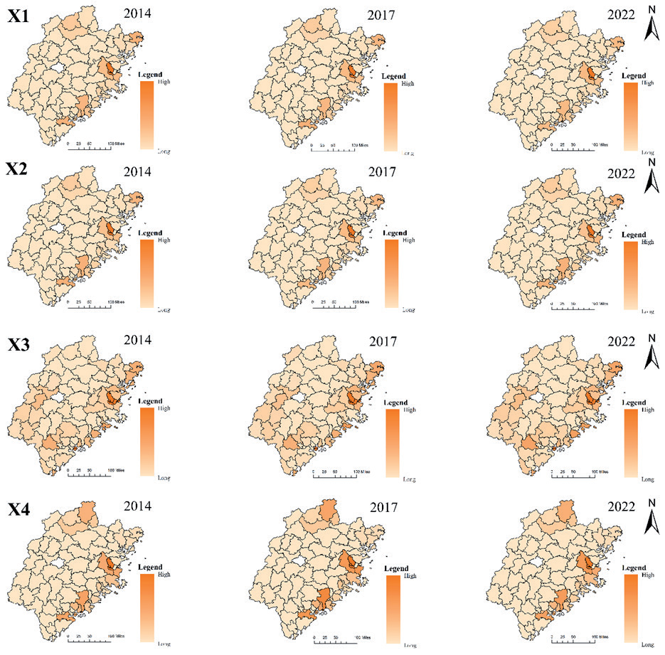
In addition, Longyan City, located in the western part of Fujian, is also a high-value area in terms of precipitation influence. Because Changting County, Liancheng County, Shanghang County, and other regions are important agricultural production areas constrained by their geographic location, precipitation, and seasonal variations, which are directly related to local agricultural production efficiency and ecosystem stability, and have a significant impact on the degree of coupling and coordination of PLE functions in the region.
The low-value area of the degree of influence of natural geological conditions is mainly concentrated in the inland area of Fujian Province and is influenced by the topographic characteristics of Fujian Province, which is high in the northwest and low in the southeast. The mountainous and hilly areas are mainly distributed in the inland areas of Fujian Province. Due to the relatively single terrain type and wide continuous distribution, the spatial heterogeneity between regions is small, and the land use functions affected by natural geographical conditions show high homogeneity, with relatively limited influence on the degree of PLE coordination.
From the perspective of the overall change in the importance of each influencing factor (Fig. 5), the spatial pattern of the degree of influence under socio-economic characteristics changes significantly. The high value of per capita consumption expenditure (X5) shifts gradually from Nanping City (Jianyang District, Yanping District, Songxi County, etc.), Ningde City (Shouning County, Zhouning County, Xiapu County) in northern Fujian, and Zhangzhou City (Zhao'an County, Yunxiao County, Zhangpu County) and other districts and counties in southern Fujian to Fuzhou City (Jin'an District, Minhou County, Lianjiang County, etc.) and Xiamen City (Xiang'an District, Haicang District, etc.) in the eastern coastal area. The distribution of high and low values of per capita disposable income (X6) is similar to that of per capita consumption expenditure (X5), with the high values decreasing from predominantly counties in Nanping, Ningde, and Zhangzhou to predominantly counties in Fuzhou. One possible cause of this phenomenon is that during 2014-2017, the income and consumption structure of residents in western and northern Fujian changed significantly, while the southeast coast has a solid economic foundation and changes are relatively flat. In 2022, with the continued deepening of the coastal development strategy and the accelerated agglomeration effect of the Fuzhou and Xiamen-Zhangzhou-Quan Metropolitan Areas as the province's economic core, the digital economy and other emerging industries will flourish, attracting a continuous inflow of population from other regions. The increase in residents' income drives the expansion of consumption demand, which in turn puts higher demands on the supply of living and ecological products and services, leading to a shift in the high-value area of the degree of influence of per capita disposable income (X6) and per capita consumption expenditures (X5) from the western part of Fujian and the northern part of Fujian to the southeastern coastal region. However, during the period of 2014-2022, Yanping District, located in Nanping City, shows a change from a high-value zone to a low-value zone and then from a low-value zone to a high-value zone, which may stem from the fact that in the early days, Yanping District was still dominated by agricultural production and the battery industry. In recent years, with the development of smart homes, smart wearables, and other fields, the local area has combined with the original industrial chain to develop IoT batteries that are applied to AR and VR and other fields. The upgrading of the industrial structure has led to talent concentration and economic recovery.
Fig. 5.
Spatial and temporal patterns of factors influencing the functional coupling of PLE under socio-economic characteristics.
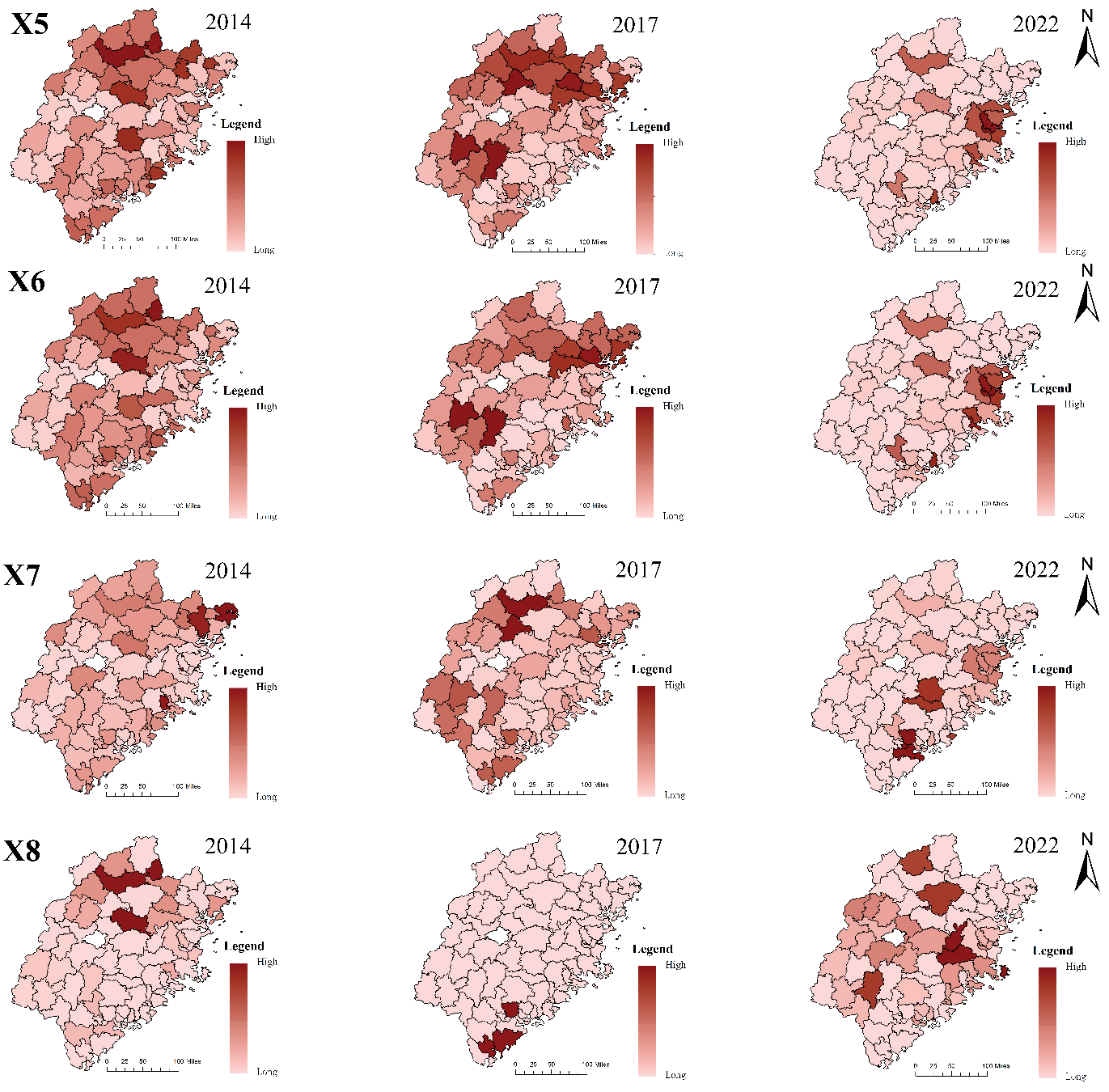
Nighttime light intensity characterizes the density of economic activities and the level of urbanization. The high value of nighttime light (X7) impact level decreases from the northern part of Fujian Province to the southeastern coastal area, mainly Zhangzhou City, Quanzhou City, Fuzhou City, and other districts. This phenomenon directly reflects the trend of population migration to coastal areas in Fujian Province. The siphoning effect of the southeastern region of Fujian, with its excellent infrastructure and abundant job opportunities, drives the demand for PLE coordination, which in turn influences the local PLE coordination. Among the influencing factors, Nanping City in the northern part of Fujian Province has remained a high-value area for nighttime lighting impact from 2014 to 2022 due to the influence of tourism development in Wuyi Mountain, but the high-value area shows a gradual trend of decreasing. The same trend occurs in Longyan City, where agricultural production is dominant, especially the labor-intensive rice cultivation industry, which remained a high-value area during 2014-2017 but gradually shifted from a high-value area to a low-value area as a result of the massive exodus of the population.
The high-value area of economic synergy (X8) impact level evolved from Nanping City, Ningde City, and Zhangzhou City districts and counties to predominantly Fuzhou City, Putian City, Xiamen City, Nanping City, and Longyan City districts and counties, and the low-value area has been shrinking in scope and decentralizing in distribution. Early decentralized distribution of the economic synergistic impact of high-value zones is affected by policy spillovers; due to the construction needs of the metropolitan area, part of the industry transferred to the inland areas of Fujian Province. In the later stage, supported by the policy of building the Fuzhou Metropolitan Area and the Xiamen-Zhangquan Metropolitan Area, the PLE functions of districts and counties in Fuzhou, Putian, Xiamen, Namping, and other areas have been further optimized. In addition, the policies of the metropolitan area construction have also produced positive spillover effects, promoting the coupled and coordinated PLE functions in Longyan City.
Discussion
Land resources, as the basic carrier of human production and life, are the basic guarantee of socio-economic stability. The economic, ecological, social, environmental, and other benefits of land are the unit of land area in a certain period of time, used directly. For a long time, under the influence of economic development, the socio-economic system has been increasing the demand for a variety of production and living functions, which threatens the ecological function of land. However, ecological security and sustainability are prerequisites for economic development. Multifunctional land use is an important guarantee for sustainable regional development in the context of the current shortage of land resources, and multifunctional evaluation of land use is the basic work of multifunctional land use.
Current studies have assessed and quantified the PLE functions of land at the national, provincial, and municipal spatial scales, but few studies have addressed the region of Fujian Province, which has superior ecological functions and a high level of economic development. Although several current studies have been conducted, they are limited to parts of Fujian Province [68] and do not cover the whole province, or they only use remote sensing to identify land types [69], neglecting the fact that human behaviors and decision-making also affect the production, ecological, and living functions of land. The novelty of this study is that, compared with previous studies, we take the whole area of Fujian Province as the study area. At a more refined county scale, we use relevant socio-economic data at the level of land use data in Fujian Province for three periods, namely, 2014, 2017, and 2022, and integrate socio-economic and remote sensing to present the evolution of the distribution pattern of the production, living, and ecological functions of the land in Fujian Province under the temporal and spatial dimensions. On this basis, the article further applies the coupled coordination model to measure the coupled coordination degree of PLE functions. It applies the geographically weighted random forest model to analyze the factors affecting the coupled coordination degree. The study helps to assess the local PLE functions in a more detailed and comprehensive way and provides a scientific basis for the refined management of land use in Fujian Province.
Firstly, this study evaluates the different types of land use functions in the study area through multiple data sources and compares the differences in the spatial and temporal distribution of land use among counties in Fujian Province. It is found that there are significant differences in the current distribution patterns of production, living, and ecology in Fujian Province. From 2014 to 2022, in the production function dimension, the overall land production function in Fujian Province shows a decreasing trend due to the dual effects of natural conditions and socio-economics. In the dimension of living function, the land production and living function of Fujian Province show an obvious upward trend, and the spatial distribution shows the gradient distribution characteristic of “high along the coast and low inland”. In the ecological function dimension, the ecological function of land in Fujian Province shows a rising trend. The high ecological function areas in Fujian Province are mainly distributed in the eastern coastal area and some mountainous counties in the Wuyi Mountain Range, which are influenced by the policy support and the construction of the protected area, and the implementation of the ecological project of soil and water erosion. The results of the study show that areas with higher levels of regional administrative and economic development tend to have higher living and ecological functions because they can obtain more policy support and resource tilting and pay more attention to economic and social benefits in the process of development [70]. However, this enhancement of living and ecological functions may often be at the cost of production functions.
Second, the study measures the coupled coordination degree of PLE functions in each county in Fujian Province during 2014-2022 through the coupled coordination model. The study finds that although the current level of PLE coupling coordination of land in Fujian Province is still at a relatively low level, it shows an overall upward trend. The evolution process deeply maps the change of the regional development concept from “economic priority development” to “balanced system development”.
Finally, because the GWRF model can effectively explain the spatial heterogeneity of the influencing factors in the local geographic space, the article applies the geographically weighted random forest model to measure the influencing factors affecting the degree of coupling coordination. We found that among the natural geographic conditions, the high-value areas of the degree of influence of elevation (X1), relief (X2), precipitation (X3), and distance to prefecture-level cities (X4) on the degree of coupling coordination are roughly distributed in two major regions. One is the districts and counties of the southeastern coastal region of Fujian Province, which is dominated by the plains region, but there are also local hilly terrains. The second is the northern region of Fujian with Nanping City as the core, which is dominated by mountainous and hilly terrain. This indicates that the PLE functions and their coupled coordination degree in the region are limited by the local topography, precipitation, and other natural conditions, which affect the spatial choice of their production, living, and ecological activities, and that the geographic conditions of the distance from prefectural-level cities provide the region with developmental resources and policy support, as well as impacts due to the accelerated process of urbanization, which in turn affects the coordination of the PLE functions in the region. The overall spatial and temporal distribution pattern of the high and low value areas of the degree of influence of natural geographical conditions is relatively stable, probably because the indicators selected for the study in terms of natural geographical conditions are all relatively stable. In the socio-economic characteristics, under the influence of the coastal development strategy, the agglomeration effect of the economy has accelerated, and the real demand for the coordination of PLE functions has driven the multifunctional use of the land and advanced the coordination of PLE functions. Moreover, the policy of metropolitan area construction has also produced positive spillover effects, promoting the coupled coordination of PLE functions in some inland districts and counties.
Fujian Province is dominated by mountainous and hilly terrain, and its development is restricted to a greater extent by natural conditions. In the process of improving the level of PLE functions coupling and coordination, Fujian Province identifies the ecological sensitivity, resource carrying capacity, and development potential of different regions, and then realizes the coupling and coordination of production, ecological, and living functions. The better level of coordination of PLE functions in the coastal region of Fujian Province is mainly because the region gives full play to the advantages of coastal location, attracts investment, and develops a private economy, which provides a strong impetus and support to enhance the overall level of development, feeds ecological protection, improves people's livelihoods, and creates a radiation-driven role to promote the inland districts and counties to share the development opportunities and achieve the optimization of the overall regional functions. The results of the study are of practical significance for land use planning and management in Fujian Province and other regions around the world. In future land planning work, PLE functions at different levels of economic development should be considered comprehensively to improve land use efficiency and achieve synergistic development of production, living, and ecological functions, which is of great significance to the sustainable development of the region.
In addition, there are some shortcomings in this study, which are likely to be addressed in future studies.
(1) Only the years 2014, 2017, and 2022 were selected as the time nodes in this study, resulting in insufficient time series data. In future studies, we will further expand the time dimension and use continuous time data to analyze the evolution in more detail. (2) In order to study the PLE functions in Fujian Province more precisely, we choose the county as the research unit, but limited by the lack of county-level statistical data, the sub-dimensions of the land use function evaluation indexes used in this study still need to be further improved. In our future research, we will establish a better evaluation index system through technical improvement and innovation to more accurately reflect the spatial and temporal evolution of PLE functions in each district and county.
Conclusions
In this study, from the perspective of coupled and coordinated development of the PLE system, integrating socio-economic data and remote sensing, and taking the counties in Fujian Province as the research object, we apply the data of 2014, 2017, and 2022 to construct the evaluation system of functional indicators of PLE. The article first applies the entropy value method and the coupled coordination model to quantitative comparative analysis and the spatio-temporal dynamic evolution process of PLE functions in Fujian Province at the county scale. On this basis, the model of geographic random weighted forest is further applied to reveal the key factors affecting the coupling and coordination of PLE. The results show that there are significant differences in the spatial distribution patterns of production, ecological, and living functions in Fujian Province, with the production function gradually weakening, and the levels of living and ecological functions in the region showing an upward trend due to the influence of the regional administrative level and the level of economic development. From 2014-2022, the level of PLE functional coupling and functional coordination in Fujian Province has significantly increased, but it is still elementary coordinated; the coupling coordination level is influenced by the joint effect of natural geographical conditions and socio-economic characteristics, and the influence of the main influencing factors has more obvious spatio-temporal heterogeneity.

