

Introduction
Natural resources play an essential role in industrial development and have substantial impacts on national economic growth [1]. China is endowed with abundant and diverse mineral resources, boasting some of the world’s largest reserves of certain minerals. As of 2020, China has identified 173 mineral types, however, the quality of these mineral resources’ is suboptimal, and their distribution is imbalanced [2]. Large-scale and super-large mines, as well as open-pit mines, are relatively scarce, and the development and utilization rate remain inadequate. As mining activities progress, a significant amount of land has suffered damage or pollution due to mineral exploitation [3, 4]. Furthermore, certain land parcels have been abandoned, left idle, or underutilized, often attributed to factors such as resource depletion, industrial restructuring, and other related issues [5, 6]. These unused lands are predominantly situated away from urban construction zones and are marked by collapsed structures, often surrounded by extensive agricultural land. Coal mines face a range of significant issues, including geological subsidence, fire hazards, damage to land resources, harm to forest and grass areas, soil erosion, and pollution through subsurface and surface water damage. It is noteworthy that existing data indicates that coal production activities in China alone have resulted in damage to approximately 2.66 million hectares of land [7, 8].
China, with a large population and limited land, faces a significant challenge regarding land issues, posing a serious obstacle to national economic development [9]. In an effort to address the shortage of land resources and promote more rational land utilization, the State Council has successively approved and issued various plans, including land use master plans, special plans for land improvement and reclamation, and detailed plans. The Land Use Master Plan is designed to protect arable land and implementing land reclamation to supplement arable land [10-12]. In 1988, the State Council introduced the Regulations on Land Reclamation, establishing the land reclamation system. Subsequently, in 2009, the Ministry of Land and Resources issued the Regulations on Geological Environmental Protection in Mining (MLR No. 44 of 2009) [13], aiming to address the increasingly serious mining and geological environmental problems. In 2011, the State Council promulgated and implemented the Regulations on Land Reclamation, signifying a new stage in the institutionalization, standardization, and legalization of land reclamation in China [14]. By 2016, amidst the prevailing green era where “ecological barriers are our insurmountable bottom line”, the General Office of the Ministry of Land and Resources issued the “Circular of the General Office of the Ministry of Land and Resources on the Work Related to the Compilation and Reporting of Mine Geological Environmental Protection and Land Reclamation Programs” (Land and Resources Regulation [2016] No. 21) [15]. This directive mandated the integration of mining enterprises’ mining geological environmental protection, treatment, reclamation programs, and land reclamation programs for combined reporting. In 2017, six departments jointly issued the “Implementation Opinion on Accelerating the Construction of Green Mines” (Land and Resources Regulation [2017] No. 4) [16]. This directive outlined the implementation of eight types of green mine construction and set higher requirements for the mining industry’s development, emphasizing the adoption of the concept of green development [17]. Throughout the years, land reclamation has played an important role in protecting and supplementing arable land resources, ensuring food security and ecological stability.
The reclamation and reuse of industrial and mining wastelands face several challenges. Mining wastelands possess dual characteristics, serving as both industrial and construction land. The contamination status of numerous historical mining sites remains unknown, and there are potential directions for reclamation and use. A critical step before implement land reclamation projects is conducting a comprehensive investigation of the land to be reclaimed. Through the soil environmental quality survey, the clarification of the soil pollution, when combined with the natural, social, and human factors of the land to be reclaimed, serves as a foundation for planning the type of reclaimed land and evaluating the applicability of the land type [18, 19]. Simultaneously, the investigation focuses on the rapid and accurate identification of the distribution and characteristics of contaminants in the soil. This critical information provides a solid foundation for developing environmental protection strategies and implementing precise remediation efforts [20, 21].
Recent research highlights that the majority of abandoned mine sites exhibit varying levels of heavy metal pollution, closely linked to activities such as mining and smelting. Urgent measures must be developed to effectively prevent and manage pollution levels, aiming to mitigate sustained, cumulative damage. In a comprehensive study, Huang et al. [22] investigated the source and migration pathways of metal analogues in the soil and groundwater of areas where Pb and Zn mining had been abandoned. The analysis revealed that the primary contaminants in the soil are As and Pb, originating from earlier smelting operations that involved As, Cd, and Hg. While lead primarily originates from the ore deposit zone, it is essential to implement measures to prevent and control the long-term release of heterogeneous metal ores into the soil of abandoned mine sites. This is essential to inhibit the ongoing deterioration of heavy metals in both soil and water environments. Xing et al. [23] investigated the distribution characteristics of heavy metal elements in the soils of coal mine reclaimed land and assessed their environmental impacts. The findings revealed that Pb contamination in the soils of reclaimed land has a significant impact, with Cr and Ni also posing certain environmental hazards. Additionally, Ran et al. [24] analyzed the features of soil heavy metal pollution and ecological risk to effectively manage environmental risks in abandoned mining areas. The results demonstrate severe contamination of the soil by As, Cd, Hg, and Pb. Furthermore, variations exist in the cumulative distribution traits and the potential ecological risk of heavy metals across different depths of the soil layer. The degree of heavy metal contamination in the bedrock is found to be interconnected with smelting activity. Moreover, research has indicated that heavy metals resulting from disused mines exert an influence on the dispersion of microbial colonies within the soil. In a comparative study of soil bacterial communities in various habitats of abandoned polymetallic mines, Yin et al. [25] discovered that the total copper and zinc content played a crucial role in the differences in bacterial community composition between tailings and reclaimed restoration areas. Additionally, they observed that the bioavailability of certain heavy metals significantly influenced the bacterial structure of naturally restored soils.
This study conducts a preliminary exploration survey on an industrial and mining wasteland in Shaanxi Province, aiming to clarify the soil environmental quality and provide guidance for land reclamation and usage. The study aims to achieve the following three objectives: (1) comprehensively grasp the basic situation of heavy metal elements such as chromium, nickel, copper, zinc, arsenic, lead, and cadmium in the surface soil of the abandoned land; (2) reveal the degree of heavy metal contamination in the surface soil of the study area using methods such as the land accumulation index and potential ecological risk evaluation; (3) clarify the correlation between the heavy metal elements in the surface soil of the land to be reclaimed.
Materials and Methods
Study Area Description
The study area is situated in a town in Shenmu City, northern Shaanxi Province, at the northern edge of the Loess Plateau and the Mu Us Sandy Land. Additionally, it lies at the junction of five provinces: Shaanxi, Shanxi, Mongolia, Ningxia, and Gansu. The geomorphological type characterizes it as a wind and sand area along the Great Wall of northern Shaanxi Province. The region experiences a dry climate with little rainfall, making it a typical ecologically fragile area in China [26, 27]. Despite its ecological fragility, the area holds significant importance due to its rich energy and mineral resources, positioning it as a critical coal resource and energy chemical base for China [28]. The study area comprises idle industrial and mining waste land with geographical coordinates ranging from 110°7′22″E to 110°22′45″E and 39°15′32″N to 39°25′17″N. It experiences a temperate continental monsoon climate characterized by four seasons, substantial day-to-night temperature differences, and a small annual rainfall with concentrated heavy rainfall. The average annual temperature is 8.5 ℃, with extremes reaching a maximum of 38.9 ℃ and a minimum of -28.1 ℃. The annual rainfall averages 436 mm, with the maximum daily rainfall recorded at 141.1 mm. The average annual evaporation is 1993 mm, with rainfall primarily concentrated between July and September each year [29]. The vegetation type is predominantly sparse scrub forest, and the soil type is dominated by wind-sand soil [30]. Some plots in the study area still exhibit scattered cinders or cinders that have penetrated the soil after being crushed by vehicles. Additionally, certain cinders from coal washing are piled haphazardly next to the plant without any covering or protective measures.
Sample Collection and Analysis
Soil Sampling and Processing
A comprehensive assessment of potential heavy metal pollution in the topsoil (0-20 cm) was conducted for areas designated for recultivation in the study region, following the guidelines outlined in DB61/T 1322-2020 [31]. Soil samples were collected at three different depths (0-5 cm, 5-10 cm, and 10-20 cm) from the topsoil of the land earmarked for reclamation using the grid technique, resulting in a total of 63 samples in 2021. Each sample, weighing 1 kg, was collected and tetrad retained after the elimination of gravel, debris, and plant roots to achieve natural air-drying. After debris removal, the air-dried soil samples underwent crushing and filtering using a nylon sieve with a 0.149 mm diameter as part of the necessary pre-treatment for the gathered soil samples [32, 33].
Sample Measurement and Quality Control
Soil samples were accurately weighed and recorded using a precision balance (Sartorius BSA224S, 0.0001 g). Soil pH in a water solution (v/v = 1:2.5) was determined using an acidometer (pHS-3C, China) [34]. The samples were pre-treated by microwave digestion following the USEPA method [35]. Subsequently, an inductively coupled plasma mass spectrometer (ICP-MS, Agilent 7900, USA) was employed for the analysis of Cr, Ni, Cu, Zn, As, Cd, and Pb in the samples [36, 37]. Parallel samples were employed in parallel experiments during the testing process, ensuring that the relative standard deviation was maintained at less than 10%. To maintain quality control, the national standard soil sample GBW07982 (GSS-40) was utilized, and the detection limit was set at 0.01 mg/ kg. Additionally, the accuracy of the analytical procedure used for instrument analysis was verified by running a standard solution after every 20 samples [38].
Assessment Methods for Heavy Metal Contamination
In this study, the contamination level of soil samples in the study area was assessed and analyzed using evaluation methods, including the Land Accumulation Index (LAI) and the Potential Ecological Hazard Index (PERI), with reference to the background levels of soils in Shaanxi Province.
The Land Accumulation Index method was introduced by Muller (1969) [39] at the Institute of Geological Sediments, Heidelberg, Germany, as a quantitative index for studying heavy metal contamination in aquatic sediments [40]. This method has been widely used in the evaluation of heavy metal contamination in soils, employing the formula (1).
In the formula,
Table 1.
The classification of
| Level | Contamination level | |
|---|---|---|
| 6 | extreme | |
| 5 | heavy to severe | |
| 4 | heavy | |
| 3 | moderate to high | |
| 2 | moderate | |
| 1 | None to mild | |
| 0 | None |
To evaluate the toxicity of heavy metals and their environmental impact on soil pollution levels, the Potential Ecological Hazard Index (PERI) was introduced by the Swedish scientist Hakanson (1980) [43]. The method integrates the analysis of heavy metal concentrations in soil with ecological and environmental effects, supported by toxicological studies [44]. Utilizing an index grading system with comparable and equivalent parameters, the method further assesses outcomes to identify the pollutant types, thereby determining focal points for pollution research, as expressed by the formula (2).
In the formula,
The
Statistical Methods
Descriptive statistical analyses of heavy metal content in topsoil were conducted using Excel 2010. One-way ANOVA and Spearman’s correlation analyses were performed with SPSS 22 (IBM SPSS Statistics, version 22) at the 95% significance level. All graphs presented in this paper were generated using ORIGIN Pro 2023b (OriginLab Corp.).
Results
Descriptive Statistics of Soil Heavy Metal Content
in the Study Area
The study revealed that the pH of the surface soil in the study area ranged from 7.9 to 8.1, indicating an alkaline nature. The status and descriptive statistics of the contents of seven heavy metals in the surface soil are presented in Table 3. The average contents of Cr, Ni, Cu, Zn, As, Cd, and Pb were 42.6, 19.7, 19.7, 47.7, 8.6, 0.10, and 21.3 mg/kg, respectively. The average contents of Cr and Ni in the surface soil were slightly lower than the background value of the soil environment in Shaanxi Province, while the contents of other heavy metal elements exceeded the background value. Remarkably, the average soil Pb content exceeded the background value by 100%. It is noteworthy that the heavy metal contents in the surface soil samples of the study area exhibited significant variability. Only 4.8% of the soil layers had a coefficient of variation (C.V.) of less than 10%, indicating low variability. In contrast, 52.4% of the soil layers have a C.V. between 10- 30%, reflecting a level of variability. Furthermore, 42.9% of the soil layers had a C.V. of more than 30%, indicating a high degree of variability.
Simultaneously, the distribution of seven heavy metals in the surface layer at different profile depths (0- 5 cm, 5-10 cm, and 10-20 cm) exhibited variations. While the average contents of Cr and Ni were consistently lower than the background values of Shaanxi Province, and the average contents of As in the 0-5 cm layer were also lower than the background values, the average contents of Zn and Cd were comparable to those of Shaanxi Province. However, the average contents of the remaining five elements in the 5-20 cm layer were all higher than the background values of Shaanxi Province, with median exceedance rates of Cu, Zn, As, and Pb reaching 100%. The average content of five elements in the 5-20 cm soil layer exceeded the background value of soil elements in Shaanxi Province, with a 100% exceedance rate for samples of Cu, Zn, As, and Pb. The trend of the median of the data aligned with the average content of heavy metals in each soil layer. Overall, the heavy metal content in the surface soil layer was lower than that in the deeper soil layer, a trend consistent with the results of the spatial distribution study in the wind-sand area [46]. In comparison with the risk screening value of GB 15618-2018, there is no indication of soil heavy metal element content pollution in the study area [47].
Table 3.
Descriptive statistics of heavy metal content (mg·kg-1) in topsoil of wasteland to be recultivated.
Fig. 1.
The
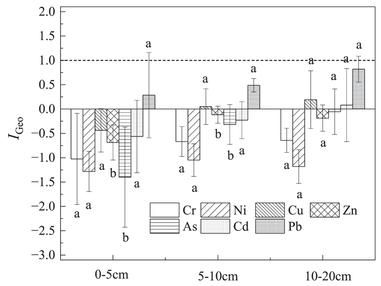
Evaluation of I G e o
The evaluation results of the
Assessment of the Potential Ecological Risk of Heavy Metals in Topsoil
Heavy metals in soil can contaminate the food chain, posing a detrimental effect on human health. To assess the potential ecological hazards of soil contaminated with heavy metals, it is vital to maintain objectivity when evaluating current data. In this study, the potential ecological hazards of seven heavy metals in the study area were assessed, using the background values of wind-sand soils in Shaanxi as a comparative benchmark to reflect the unique characteristics of the region.
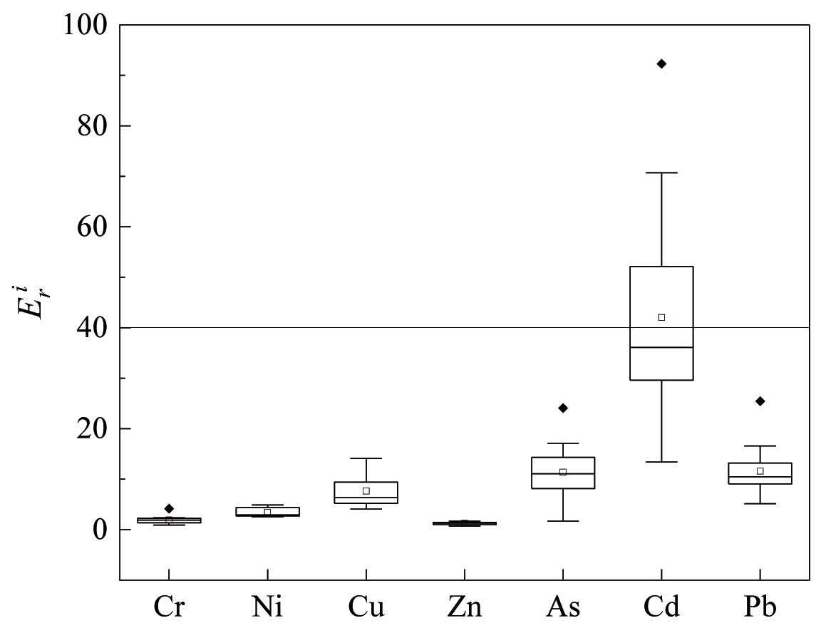
The assessment outcomes of potential ecological hazards caused by individual heavy metals in the surface soil of the study area are presented in Fig. 2, with corresponding indices of distribution and assessment levels shown in Table 4. The topsoil in the study area was analyzed for seven heavy metals, and their
Table 4.
Ecological risk factor and assessment standards.
Correlation Analysis of Heavy Metal Interactions
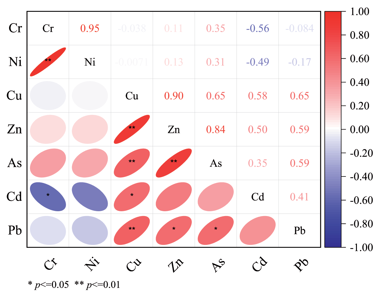
The correlation analysis illustrated the strength of the relationship between various heavy metals in the research area, conducted using SPSS 22.0. The outcomes displayed in Fig. 3 indicate that Cu was positively correlated with Zn (0.90), As (0.65), and Pb (0.65). Furthermore, the correlation between Cr and Ni was positive and extremely significant (0.95). Similarly, Zn exhibited a positive correlation with As (0.84) at a high level of significance. Additionally, there was a significant positive correlation between Pb and both As (0.59) and Zn (0.59). The contents of Cr and Ni showed a close relationship, suggesting homology [34], as did Cu and Zn. No significant correlations were found between Ni and the other six heavy metals. Cr was also not correlated with Zn, As, or Pb. Notably, Cu and As contents exhibited a significant negative correlation with Pb, indicating that an increase in Pb content led to a decrease in Cu and As contents.
Discussion
Reclaiming and utilizing abandoned land in mining areas is a crucial means of protecting and replenishing arable land resources, ensuring food security and ecological safety. Industrial and mining waste lands often possess dual attributes, serving as both industrial and construction sites. A study was conducted to examine the heavy metal content of soil in the topsoil (0-20 cm) of industrial and mining waste lands targeted for reclamation. To assess the extent of topsoil pollution in the study area and systematically understand the status of heavy metal pollution, two commonly used methods-- LAI and PERI- -were employed. The study findings show that the mean content of seven heavy metals in the topsoil (Table 3) surpassed the background level of soil in Shaanxi Province. However, it did not exceed the threshold screening value for soil pollution risk on agricultural land. Consequently, the soil is deemed suitable for agricultural activities. The evaluation results of the
The contamination of soil with heavy metals in industrial and mining areas has long been a focal point in environmental research. Soil systems exhibit a substantial buffering capacity, a crucial aspect in the study of environmental pollution chemistry. Research has shown noteworthy variations in the buffering capacity among different soil types. This characteristic is associated with soil composition and properties, as well as physical factors such as temperature and humidity. Consequently, pollutant elements may exhibit diverse behaviors in the environment, leading to varying degrees of biohazard in the soil. Numerous studies have identified that the concentration of heavy metals in the soil, both within and around mining sites, exceeds both local and national soil background values. Moreover, this heavy metal contamination exhibits a specific distribution pattern. LAI aims to reflect the extent of heavy metal enrichment resulting from human activities, while PERI takes into account elemental abundance and release capacity, thereby reflecting the combined and toxic effects of multiple heavy metals. During this investigation, it was found that the heavy metal content in the surface soil (0-5 cm) in the study area was lower than that of the deeper (5-20 cm) soil. Additionally, the Cu, Zn, As, and Pb content of the deeper soil samples exceeded the background value of the soil in Shaanxi Province by 100%. The
Reclaiming and utilizing land in mining areas has always been challenging due to uncertain soil, heavy metal contamination, and complex risk management. While the mean heavy metal concentration in the topsoil of the research region is lower than the soil pollution risk screening value for agricultural land, meeting the agricultural land standard, certain metal elements still present certain enrichment and ecological risks. Therefore, there is a need to strengthen the monitoring and assessment of typical elements. Furthermore, research should be conducted on the migration, accumulation, and redistribution of typical heavy metal elements in accordance with the physicochemical properties of the soil. This will aid in identifying the distribution pattern of typical pollutants and the main factors influencing them, laying a strong foundation for the development of control and remediation measures.
Conclusions
(1) The average levels of Cr, Ni, Cu, Zn, As, Cd, and Pb in the topsoil of the research region were 42.6, 19.7, 19.7, 47.7, 8.6, 0.10, and 21.3 mg/kg, respectively. These values were below the threshold for soil pollution risk in agricultural land, meeting the agricultural land standard.
(2) The
(3) Cr, Ni, Cu, Zn, As, and Pb in the topsoil of the study area posed minor ecological hazards, accounting for 100% of the total sample points. The potential ecological risk of the soil due to Cd contamination was high, with approximately 60% of the sample points indicating minor ecological hazards, 33.3% showing moderate ecological hazards, and 6.7% exhibiting severe ecological hazards. Approximately 60% of the samples were identified as at risk of minor ecological hazards, 33.3% at risk of moderate ecological hazards, and 6.7% at risk of severe ecological hazards. The combined potential ecological hazards fall within the range of minor ecological hazards, indicating a relatively low overall risk of potential ecological hazards.
(4) Significant similarities were detected between Cr and Ni, as well as between Cu and Zn, As, and Pb, in the surface soil samples collected from the study area.

