

Introduction
Karst is a term that refers to a special landscape containing caves and an extensive underground water system [1], and it is one of the most ecologically fragile landform types with a very fragile geological setting and an intense karst process [2, 3]. In this region, carbonate rocks are usually dissolved under the work of acidic waters, which are derived from CO2 present in the soil and in the air, forming complex above-underground geographic structures [4, 5]. Therefore, studies on resources and pollutants are facing huge challenges, and some studies have been carried out during the past two decades [6, 7]. With the growing development intensity of humans exploiting nature, population pressure and unreasonable land use changed the landscape structure of the karst region, accelerating the emergence of ecological and environmental problems in the region such as soil degradation, fertility depletion, land desertification, and biodiversity reduction, and caused a prominent contradiction between ecological protection and social and economic development [8]. The fragility of the karst ecosystem determines its vulnerability and difficult recovery from desertification [9]. Research focused on a realistic strategy in the karst area has been widely concerned. It is a very prominent environmental issue of ecological construction in western China and also one of the major obstacles of karst regions in southwestern China in sustainable development [10].
As the center of the karst region in southern China, the topography of Guizhou province is more complex compared with other provinces, including at the same time mountainous regions, hills, basins, and even high mountains, valleys, and so on [11]. Among them, the Guizhou karst landform is the most representative [12]. Karst landform in the province can be divided into four types; karst canyon, karst peak cluster depression, karst plateau, and karst trough valley [13]. The total area of the karst landform is 109084 km2 or 62% of the total land area. Strong water erosion and interstitial, variable, and tilted surface uplift of earth crust and complex geological process of the epigenetic zone, since Neogene in rock desertification processes form rich and colorful karst landform in Guizhou and soil conservative water, fertilizer, and the productivity of land, differ in different karst landforms. Thus, the carbon cycle characteristics are different [14, 15].
Soil carbon pool is the biggest carbon pool in terrestrial ecosystem carbon pools, and SOCD is an important indicator in evaluating soil organic carbon condition as well as the core content of global carbon cycle research. SOCD has important relations to nutrient supply and prevention of soil erosion [16, 17]. Carbon fixed during photosynthesis in plants enters the soil organic carbon pool through plant residue decomposition and soil microorganisms metabolic processes. Accumulating soil organic carbon enhances soil structure, sustains soil fertility, and aids in reducing atmospheric CO2 levels. The decrease in soil organic carbon storage can directly cause the soil quality decline, appearing as a rapid decrease in the ability of soil to supply nutrients to plants, soil tilth, and air and water permeability [18]. Soil organic carbon content generally decreases with depth, being higher in the surface soil and decreasing with depth. Moreover, soil type, climate, vegetation type, and land use practices are additional factors influencing the distribution of soil organic carbon. For instance, forest soil in humid climates typically contains higher organic carbon, whereas grassland soil has lower levels. The nature of karst rock desertification is that the soil quality changes, mainly in the physical, chemical, and biological properties [19]. Studies on soil ecosystem degradation caused by karst rock desertification by domestic and foreign experts mainly focus on aspects of the reason for soil rocky desertification, characteristics of soil degradation, the vegetation recovery of degraded ecosystems, etc. [19, 20]. While studies on the carbon cycle in soil and the distribution of soil organic carbon in different karst landforms and rock desertification backgrounds are few [21]. The carbon transfer process in karst systems is dominated and controlled by soil carbon, and SOCD becomes the dynamic mechanism driving and restricting carbon transfer in surface-layer karst systems [22]. These processes are in dynamic change due to changes in soil genetic characteristics and environmental conditions. Therefore, conducting comprehensive research on the spatial variation of soil organic carbon and human influences on it in karst regions is crucial for understanding soil carbon cycling mechanisms and directing land use planning and environmental conservation efforts. Systematically analyzing the spatial distribution of organic carbon and assessing human impacts can establish a scientific basis for future soil management and ecological restoration in karst regions [23].
Through taking SOCD in typical karst ecosystems and non-karst ecosystems in southwest China as research subjects. This research discussed the distribution characteristics of organic carbon density and its internal connection with karst topography and soil environmental factors. The distribution pattern of SOCD in karst ecosystems and its driving mechanism were illuminated. The response regularity and its internal mechanism of SOCD in the degradation, recovery, and evolution processes of the karst rock desertification ecosystem were illuminated. We also provided references for the reconstruction of rock desertification ecosystems and coping with the source reduction and sinks of carbon cycles in global climate change.
Materials and Methods
Study Region Overview
This paper chose 4 typical karst regions and 1 non-karst region, 5 research subjects in total. The non-karst region is located in Zunyi County, Zunyi City, Guizhou Province, Study region I, and 4 typical karst regions of different topographical features are respectively located in karst Grand Canyon, Guanling County, Guizhou Province, Study region II, karst peak cluster depression, Libo County in Guizhou Province, Study region III, karst plateau, Puding County, Guizhou Province, Study region IV, karst trough valley, Yinjiang County, Guizhou Province, Study region V. Specific geographical location and basic information were shown in Fig. 1.
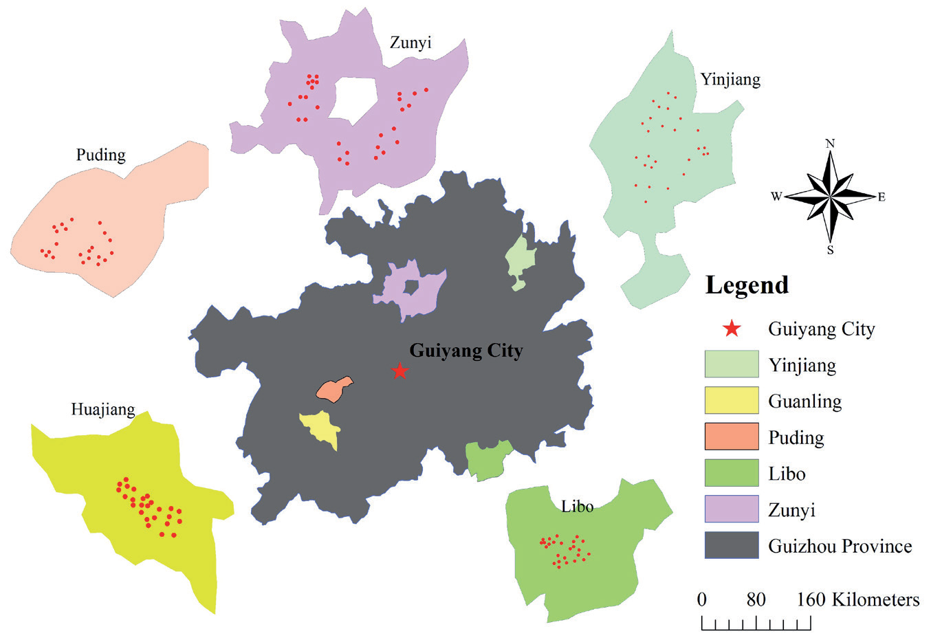
Zunyi County (non-karst region) is located in the northeast of Yunnan-Guizhou Plateau, with geographic coordinates of 105°36′-108°13′E and 27°8′-29°12′N. It belongs to the Baipu tributary area of the Yangtze River basin, with no large river water system in the region. The terrain is high in the northwest and low in the southeast, with the Lou Mountains and its north-south branch as its skeleton. It belongs to the subtropical monsoon climate zone, with an average annual temperature of 14.7ºC and an average annual precipitation of 1200 mm. Subtropical evergreen broad-leaved forest and mixed broadleaf-conifer forest where native vegetation was mostly destroyed and now the remaining are few trees and shrubs, herbs, vines, etc. Guanling County (karst canyon) belongs to the Beipanjiang water system, the upper reaches of the Pearl River. The river valley is deep, and the basin is small in area. The terrain undulation is large, with an elevation of 450 m to 1450 m and a relative height difference of up to 1000 m. The average annual precipitation of the region is 1100 mm, and precipitation is mainly distributed from May to October, accounting for 83% of the total rainfall throughout the year. The vegetation type was similar to Zunyi County (non-karst region). Libo County (karst peak cluster) is located at 107°52′10″-108°05′40″E and 25°09′20″-25°20′50″N, belonging to the Longjiang Water System, a tributary of the Pearl River basin. The elevation ranges from 430 to 1078 m, with most of the elevation around 800 m. Except for a very small amount of sand shale exposed in some parts, most parts of the region are the exposed karst peak cluster and peak forest landforms composed of pure dolomite and limestone. The vegetation types were evergreen broad-leaved forests and broad-leaved coniferous forests. And there were also rich in vegetation due to the complete protection of the local area. Study Area IV: The Houzhaihe catchment of Puding County (karst plateau) covers an area of 81 km2, with geographic coordinates of 105°40′43″-105°48′2″E and 26°12′29″ -26°17′15″N. The elevation at the watershed between the Yangtze River and the Pearl River water systems ranges from 1223.4 to 1567.4 m. There are karst caves, subterranean streams, and other surface types under the ground. The air pressure is between 806.1 and 883.8 hpa. The evergreen conifer forest is an evergreen deciduous broad-leaf mixed forest where the original forest vegetation is reclaimed as agricultural land. Yinjiang County (karst trough valley) is located at 108°17′52″ -108°48′18″E and 27°35′19″-28°20′32″N, belonging to the Wujiang water system of the Yangtze River basin. The maximum east-west distance is 62.5 km, and the maximum north-south distance is 75.8 km. It is located in the transitional slope zone from Yunnan-Guizhou Plateau to Xiangxi Hill and Sichuan Basin, between the low-mountain hilly area in eastern Guizhou and the middle-mountain canyon in northeastern Guizhou. The highest peak of the Wuling Mountains, Mount Fanjing, is located in its eastern part, forming a terrain that is high in the east and low in the west, sloping from southeast to northwest. The vegetation types were evergreen conifer broad-leaf mixed forest. It belongs to the subtropical warm humid climate zone, with an average annual temperature of 16.8ºC and an annual precipitation of around 1100 mm in Table 1.
Soil Sampling
We sampled in different sampling areas and set 1×1 m quadrates in each area. A five-point sampling method is used to excavate soil profiles in the quadrate, and the soil samples in one quadrate are uniformly mixed into one sample and stored. Soil samples were collected through the layered sampling method. Soil samples were sampled by bottom-up layered sampling of the soil profile. The excavation depth of the soil profile was no greater than 100 cm. The soil layer was excavated from the basement rock or parent material to 100 cm underground. It was divided into a total of 10 layers, including 0 to 10 cm, 10 to 20 cm, 20 to 30 cm, 30 to 40 cm, 40 to 50 cm, 50 to 60 cm, 60 to 70 cm, 70 to 80 cm, 80 to 90 cm, and 90 to 100 cm. The background information of each sampling point should be recorded, along with the environmental information such as slope gradient, elevation, aspect, and slope position. A total of 126 sampling points were surveyed and collected, and a total of 968 soil samples were collected [24].
Table 1.
. Main overview of the research area.
Soil Analysis Methods
The soil samples were naturally air-dried at room temperature and screened at 150 μm. Then, total SOC levels were determined by K2Cr2O7 oxidation at 170-180ºC followed by titration with 0.10 mol L-1 FeSO4, and 10% repetition was conducted (Herold et al. 2014).
Soil acreage was calculated using GIS information and field survey data. Bulk density was measured layer by layer from the top to the bottom of the soil profile using the cutting-ring method. Soil thickness was recorded according to the type of ecological niche using an iron measuring rod that was 60 or 120 cm long, based on the soil mass at different depths. The boulder content was surveyed using a linear transect. Due to the existence of complex landscapes in the karst area, the length of the linear transect was set at 10 m. Although more accurate information could be obtained from a longer transect, establishing a longer transect would have required excessive effort. Grid cells with rock coverage were surveyed using a tape measure.
Results
Main Soil Properties Under Different Topographical Features
Karst development area has obvious stripes for being controlled by geological structure forming cross distribution of two landforms of karst and non-karst. Due to the common interbedding of carbonate formation and fragmental rocks and the fact that the whole sediment structure is mainly carbonate, carbonate formation is discretely striped in horizontal distribution after fold fracture and denudation erosion. It manifests as two different landforms evolving and developing together and intercrossing with each other. Five study regions represent 5 typical landform regions in the southwest and 4 study regions chosen represent respectively 4 typical landform types in the southwest; karst plateau mountains, plateau basins, plateau canyons, and plateau trough valleys. Specific basic characteristics are shown in Table 1. This study studied the distribution of basic attributes of different karst landforms in the study region scale, and the specific results are shown in Table 2. The basic attributes of 968 soil samples from 126 sampling points in 5 landform types have different variations.
Due to special geological and climatic conditions, the soil environment of the karst region has essential features of bedrock exposure, small soil stock, discrete distribution, complex, diverse microrelief, etc. Thus karst soil thickness, rock outcrops, and gravel content are all higher than those of non-karst regions. The gravel content in different karst landforms shows that karst trough valley>karst canyon>karst peak cluster depression>karst plateau. The soil thickness shows that: karst plateau>karst canyon>karst trough valley>karst peak cluster depression. The gravel content and organic carbon content show that karst peak cluster depression>karst canyon>karst trough valley>karst plateau. The inspection result of multiple comparisons Duncan shows that soil organic carbon contents of different landform rock desertification are obviously different, which shows that karst landform has significant influences on soil organic carbon content (P<0.05).
Characteristics of SOCD Profile in Different Landforms
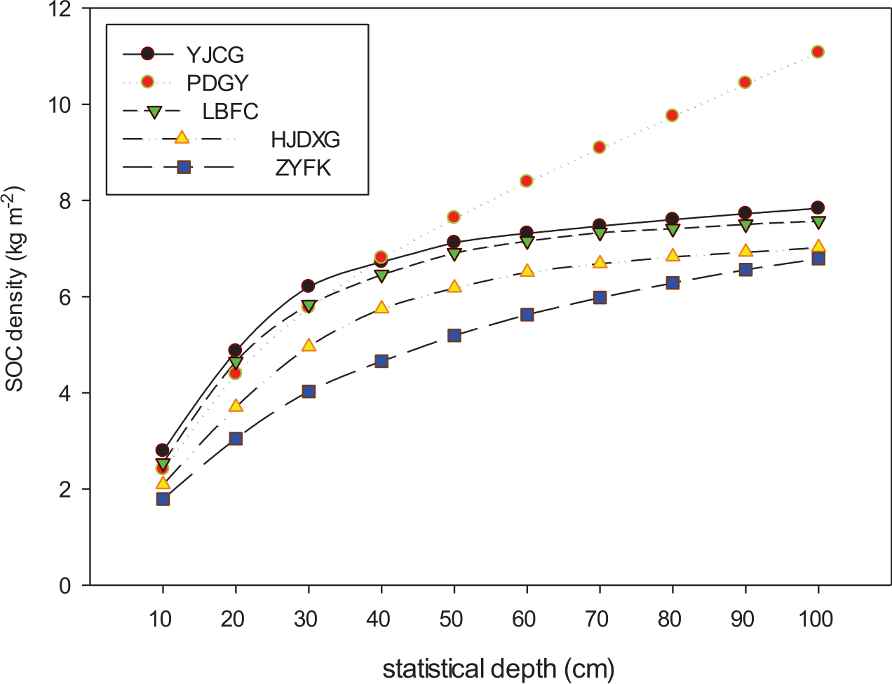
This research studied the spatial distribution of SOCD in different landforms in the southwest from two aspects of karst and non-karst, and the specific results are shown in Fig. 2. The maximum value of organic carbon density (0-100 cm) in the non-karst region is 61.22 kg·m-2 and the minimum value is 0.25 kg·m-2, and the average value (0-100 cm) is 5.61 kg·m-2 while the maximum value of organic carbon density (0-100 cm) in the karst region is 94.11 kg·m-2, the minimum value is 1.22 kg·m-2, and the average value (0-100 cm) is 5.01 kg·m-2. The characteristics of the SOCD profile in different landforms are shown in Fig. 2. From Fig. 2, it can be seen that the vertical variation features of SOCD in different landforms are different; on the whole, SOCD of the karst region is higher than that of the non-karst region; SOCD content of soil thickness of 0-0.40 m rapidly rises along with soil depth increases; and SOCD value of soil thickness of 0-0.40 m is YJCG>LBFC>PDGY>HJDXG>ZYFK. While soil thickness is 0.40-1.00 m, except SOCD of the karst plateau rises rapidly, SOCD of other types all increases slowly. The characteristics of the SOCD profile in different landforms show that: PDGY>YJCG>LBFC>HJDXG>ZYFK. Through multiple comparisons, Duncan, the inspection results show that SOCD in different karst landforms is obviously different, and SOCD in non-karst regions has no significant difference (P<0.05). Thus, it shows that karst landforms have significant influences on soil organic carbon content.
Table 2.
Main soil properties in the study area under different geomorphological characteristics.
Composite Influence Factors of SOCD in Different Landforms
Influence Factors of SOCD in Non-Karst Region
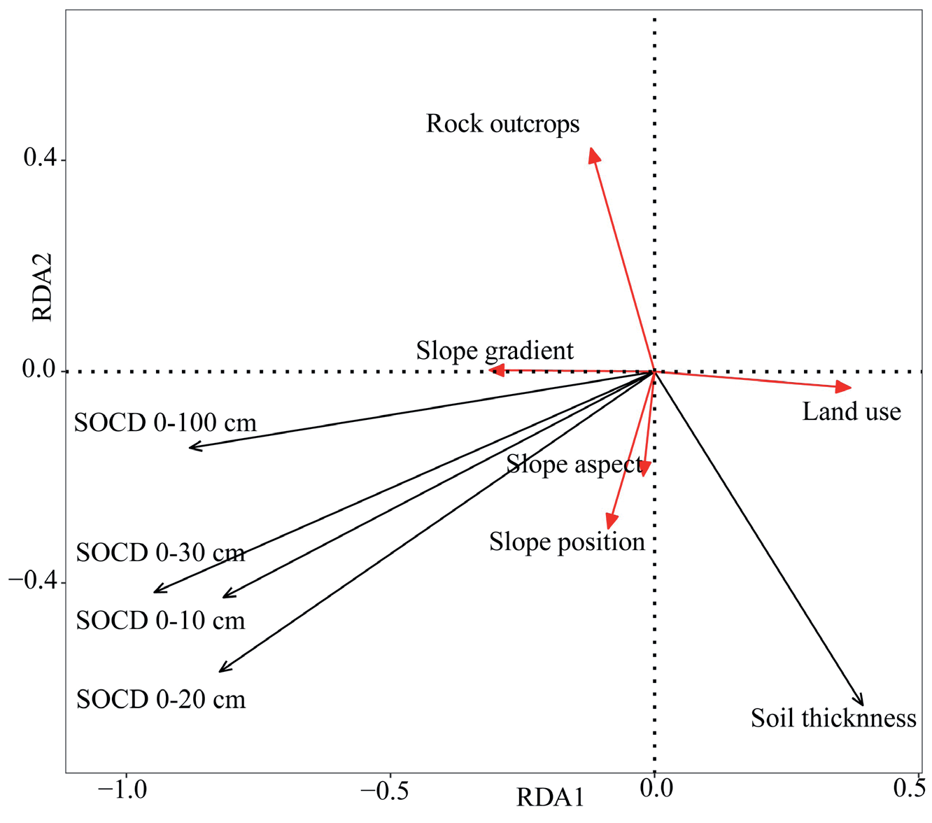
The redundant analysis (RDA) method is used to analyze soil properties and their interrelation with environmental factors. Using Canoco 5.0 software, first organic carbon content was analyzed by DCA analysis (Detrended Canonical Correspondence Analysis) to generate gradient and length, then linear models (RDA or PCA) were selected using factors to carry out analysis and comparison. Land use was valued according to types of land use, and types of land use were divided into five classes according to the degree of human disturbance: Class 1 mainly includes arbor woodland, arbor and shrub woodland, and shrubby forest, which have the least human disturbance and the assignment value is 1; Class 2 is mainly wasteland with an assignment value of 2; Class 3 is mainly abandoned cultivated land with occasional animal husbandry phenomenon and an assignment value of 3; Class 4 is mainly grassland and shrub grassland, mainly grazing disturbance, with an assignment value of 4; Class 5 is all kinds of cultivated land, including paddy fields, dry land, garden land, sloping farmland, fruit forest land, where the intensity of human disturbance is the highest with the assignment value of 5. This research adopted RDA sorting analysis of the relation between organic carbon density and the factors. A sorting diagram of relations between soil organic carbon and comprehensive factors in the non-karst region is shown in Fig. 3.
Fig. 2.
SOC density of different landscapes under different statistical depths. (YJCG: karst trough valley; XYFC: karst peak cluster depression; HJXG: karst canyon; PDGY: karst plateau; ZYFK: Non-karst region).
RDA sorting can reflect the influence degree of each influencing factor on the variation of organic carbon density directly. The length of connecting lines of environmental factors represents the correlation between soil organic carbon contents and influence factors and longer lines and smaller included angles in the RDA plot indicate stronger positive correlations between soil organic carbon content and environmental factors. When the included angle is less than 90°, it means the influence factor is positively correlated with the organic carbon content, while it is larger than 90°, it means the influence factor is negatively correlated with the organic carbon content. The smaller the angle included, the higher the correlation between organic carbon and the influence factor. As shown in Fig. 3, SOCD has a significant positive correlation with slope gradient, slope aspect, and slope position (P<0.05). SOCD has a negative correlation with land use and soil thickness. While the influence of rock outcrops on SOCD shows correlations of different degrees in different soil thicknesses. Among them, SOCD (0-30), SOCD (0-10), and SOCD (0-20) were negatively correlated with rock outcrops, while SOCD (0-100) was positively correlated with rock outcrops. The angle between SOCD (0-100) and slope gradient is the smallest indicating, that slope gradient has the greatest influence on SOCD (0-100), and the angle between SOCD (0-20) and slope aspect is the smallest, indicating that SOCD (0-20) is highly-significant and positively correlated with slope aspect, and the correlation coefficient is the largest (P˂0.05). On the whole, rock outcrops, land use, and soil thickness were remarkably negatively correlated with SOCD, indicating that SOCD in the non-karst region decreased gradually with the increase of soil thickness and the human disturbance degree (land use).
Influence Factors of SOCD in Karst Regions of Different Landforms
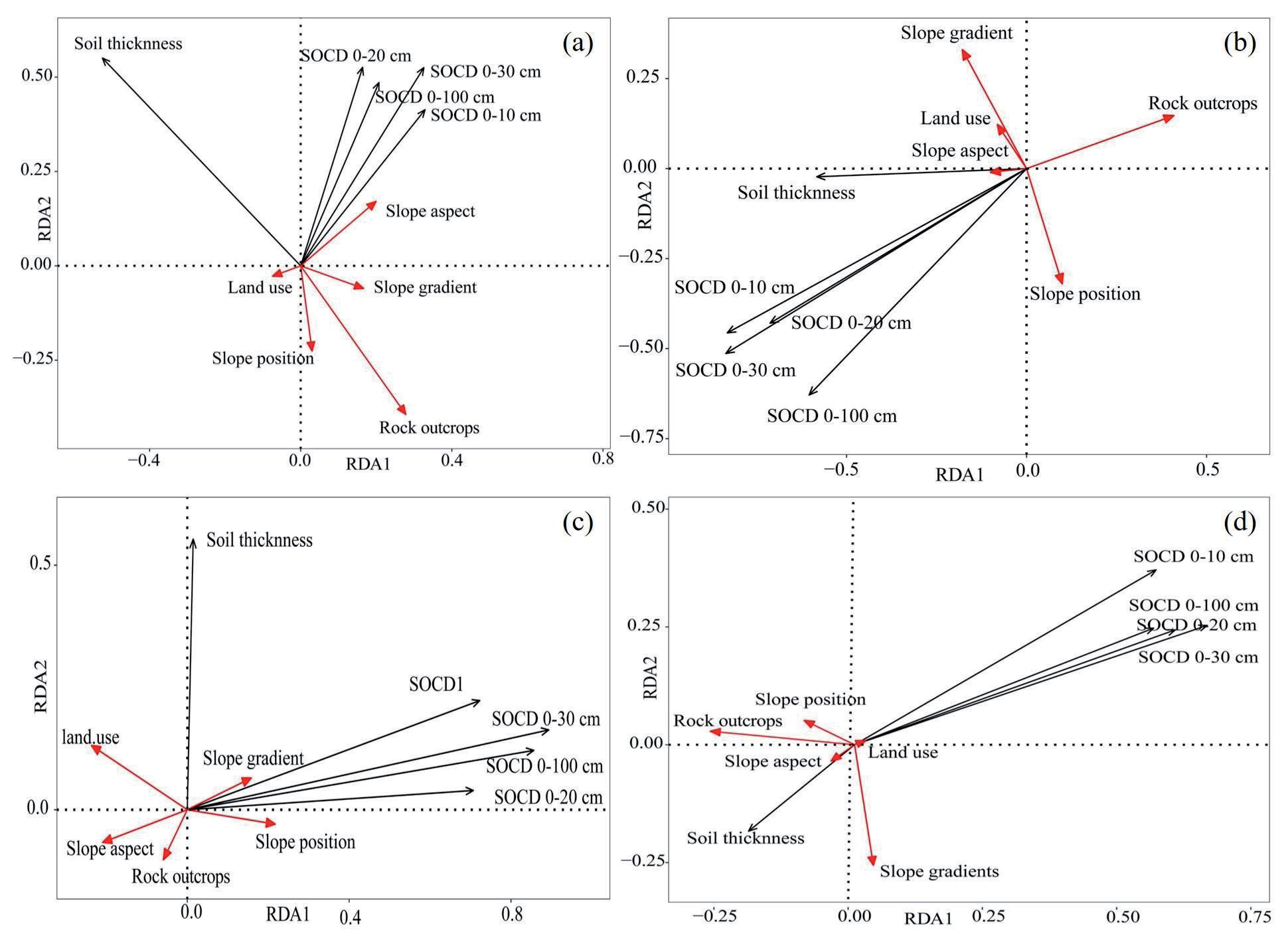
Landform plays a significant role in spatial distribution and variation of karst SOCD (Fig. 4). The driving factors of SOCD in different landforms are different. In the karst canyon region, SOCD has significant positive correlations with slope aspect, slope gradient, and soil thickness, and the angle between SOCD and slope aspect is the least, indicating the most significant correlation (P<0.05). SOCD has significant negative correlations with slope position, land use, slope position, and rock outcrops. And the influence degree of each influence factor on organic carbon density from high to low is: soil thickness>rock outcrops>slope aspect>slope position>slope gradient>land use (P<0.05). In the karst peak cluster depression region, SOCD has significant positive correlations with soil thickness, slope position, and slope aspect. The significant negative correlation with various influence factors on organic carbon density from high to low is: soil thickness>slope gradient>slope position>rock outcrops>land use>slope aspect. In the karst plateau region, SOCD has significant positive correlations with slope gradient, slope position, and soil thickness, with a significant negative correlation with land use, rock outcrops, and slope aspects. The influence degree of influence factor on organic carbon content from high to low is: soil thickness>land use>slope aspect>slope position>slope gradient>rock outcrops. In the karst trough valley region, SOCD has significant positive correlations with land use, and slope position, while significant negative correlations with soil thickness, rock outcrops, slop aspects, and slope gradient. The influence degree of each influence factor on organic carbon content from high to low is: slope aspect>rock outcrops>soil thickness>slope position>slope gradient>land use.
Discussion
Comparison of Organic Carbon Content of Karst Soil and Non-Karst Soil
Soil is a very complex synthesis formed by secular evolution in nature, also the continuous variant of space-time, and has complexity and spatial variability due to soil formation from parent material, terrain, climate, vegetation, and so on, and the interference of human activity [25, 26]. Under the influences of many natural and human factors, such as different topographical features, landform factors, and human disturbances, the physicochemical property of soil shows a patchy or gradient pattern in spatial distribution [27]. The karst ecological environment is complex. Outcrop heterogeneity and diversity of crack structure of rocks under the ground form multi-layer ecological spatial structure. Rock outcroppings and extreme development of cracks caused the spatial heterogeneity of karst soil by making the horizontal and vertical distribution of soil discrete, the soil mantle extremely fractured, and the thickness distribution of soil uneven [28]. In particular, there is a large amount of sloping soil in karst regions, and the average depth is only 4 to 20 cm. Therefore, the study of organic carbon and organic carbon density in topsoil (0-20 cm) in the karst region is the basis for evaluating soil carbon sequestration in this area. In different karst landforms, the soil organic carbon content (0-20 cm) was between 10.62 g and 89.11 g·kg-1 (Table 3), and the average soil organic carbon content was 23.07 g·kg-1. The content of soil organic carbon is similar to that of Sanjiang Plain in China and Ursanbala, Tanzania, which is higher than that in the small watershed of the Loess Plateau and lower than that of the Mediterranean Basin [29-31]. The geological landscape of the Loess Plateau is broken, and the low mountains and hills are continuous [32, 33]. Due to the long-term serious soil and water loss, the soil is barren and the soil and water loss is aggravated, resulting in a large amount of soil organic carbon loss, so the organic carbon content in the Loess Plateau is low. The Mediterranean Sea is a typical Mediterranean climate region, with dry heat and less rain in summer and warm and humid winter, which is beneficial to the growth of vegetation and increases the input of carbon sources to the soil, while the climate is dry with little rainfall in karst areas and the soil carbon input is smaller than that in the Mediterranean region. Organic carbon in the soil is the equilibrium result of the amount of plant residues entering the soil and the decomposition loss under the action of soil microorganisms. Its content is controlled by many physical, biological, and human factors, such as the climate, vegetation, soil properties, agricultural management practices, and so on, and there is an interaction between various factors [34].
Fig. 4.
The relationship between SOCD and geographic factors in different karst landforms. Note: (a) is karst canyon; (b) is karst peak cluster; (c) is karst plateau; (d) is karst trough valley.
Soil organic carbon reserve content in southwest China is relatively low. In this study, the organic carbon density of karst soil and non-karst soil is much lower than the average level of organic carbon density in China (9.6 kg·m-2). It is also much lower than the average SOCD in the Loess Plateau region of northwest China and Sanjiang Plain in North China, which reflects that the karst geological environment in southwest China has a profound influence on SOCD. The main reason is that the soil is dispersed and the soil thickness has obvious differences due to the karst geological environment in southwest China. The average depth of topsoil in most areas in this study was 5 to 11 cm. Therefore, the topsoil in the karst area (0-20 cm) was studied. The soil carbon density in the study regions is also lower than that of karst in Guangxi, China (9.80 kg·m-2), which indicates that the high spatial heterogeneity of soil in karst regions results in large spatial variations of organic carbon density [35]. At the same time, due to the special binary hydrological structure and complex topographic forms such as complex peak cluster depression, hoodoo, funnel, and so on, the soil formation rate is slow, the soil layer is shallow and discrete, the exposed area of bedrock is large, the terrain is undulant and changeable, and the microrelief is very complex. Outcrop heterogeneity and diversity of crack structure of rocks under the ground form multi-layer spatial structures and many different types of small ecosystems, resulting in a large loss of organic carbon in karst soil [36, 37].
Driving Factors of SOCD under Different Topographical Features
A large number of studies have shown that karst landforms in Guizhou can be divided into three genetic types due to the big differences in causes and combination forms of geological and topographic features: dissolution landform, dissolution-erosion landform, and dissolved structural landform [38]. Among them, the dissolution landform can be divided into four types: karst canyon, karst peak cluster depression, karst plateau, and karst trough valley. The karst area of the Guizhou Province accounts for 73.60% of the total land area of the province, and 95% of the counties (cities) in the province have karst distribution. Therefore, the study of the driving factors of SOCD under different topographical features in the Guizhou area has an obvious promoting effect on the mechanism of soil organic carbon sequestration. The dynamics of soil carbon mainly depend on the dynamic balance between carbon input and output, and all the factors that can affect the accumulation and decomposition of soil organic carbon may affect the distribution of SOCD [39, 40]. On the whole, the value of SOCD is affected by many natural and human factors, such as environmental factors, soil properties, the change in land use, etc. A karst ecosystem has the characteristics of high calcium, carbonate, alkalescence, unbalanced nutrients, rapid hydrological processes, etc. The composition, structure, stability, and microbial transformation process of soil organic carbon may be different from other ecosystems. In addition, once the karst natural ecosystem is degraded or reclaimed into farmland (fertilizing) by human disturbance, soil organic carbon is easy to lose quickly [41, 42].
Table 3.
Comparison of Carbon Contents in Karst and Non-Karst Soils.
Comprehensive analysis shows that the distribution characteristics of organic carbon density in karst soil are the result of the interaction of environmental factors and human activities [43]. However, these environmental factors have both direct and indirect components under different topographical features. In karst canyon, and karst peak cluster depression regions, soil thickness has the greatest influence on organic carbon density, which is the direct influencing factor, and the influence degree of land use is the least, which is the indirect influencing factor [44]. So soil thickness is the key factor of SOCD in karst canyon and karst peak cluster depression regions. Because human activities in canyon and peak cluster depression regions are small and the land use is single. It has few influences on the input and output of SOCD. Land use is the largest, and the rock outcrops are the smallest in the karst plateau regions. People in the karst plateau regions tend to plan for all kinds of agricultural production land, resulting in a large amount of loss of topsoil due to frequent human disturbance. Therefore, as a result, rock outcrops and soil thickness directly determine the total amount of soil and then affect the organic carbon density in karst plateau regions. In karst trough valley regions, SOCD is most affected by rock slope aspects. The big difference in sunlight and temperature in different slope aspects results in different microclimates, vegetation types, and growth, and degradation rates of soil organic matter in the regions. The natural organic carbon density shows different characteristics. Land use in karst trough valley regions has the least influence, mainly because people in these regions tend to leave the land idle and succeed in grassland, various forest land, or degraded to wasteland through natural ecosystems. Human activities are less, and then its influence on SOCD is the smallest. Due to the complexity of SOCD and the diversity of karst environments, the main factors are different in regions of different landforms. Therefore, different ways and methods should be adopted according to the differences of the karst environment for reasonable and effective utilization of SOCD.
Conclusions
This study provided novel insights into how topography and landform features affected the content and stability of soil organic carbon. That emphasized significant variations in soil organic carbon density (SOCD) across different landscapes. The average SOCD (0-100 cm) was 5.61 kg·m-2 in non-karst regions and 5.01 kg·m-2 in karst regions. The vertical variation characteristics of SOCD under different topography and landform characters are different. Generally, SOCD increased with soil depth. The SOCD order across different landforms was karst plateau>karst trough valley>karst peak cluster depression>karst canyon>non-karst area. The driving factors of soil organic carbon were different under different landform conditions. This study examined the factors affecting local karst soil organic carbon density (SOCD). Soil thickness primarily influenced SOCD in the karst canyon, karst peak cluster depression, and karst plateau regions. The slope aspect was the key determinant in karst trough valley regions. It reflected the global context from a local perspective. The study emphasized the unique landscapes of karst areas and highlighted the importance of maintaining and enhancing soil organic carbon for soil health, ecological balance, and erosion control. These fragile landscapes required concentrated efforts to increase soil carbon levels. The study underscored the importance of understanding organic carbon distribution for effective land-use planning. Implementing optimal planting and cultivation methods could enhance land-use efficiency, reduce dependence on fertilizers, and promote sustainable agriculture. This approach not only improved soil health but also contributed to mitigating climate change by sequestering CO2 and reducing the greenhouse effect.

