

Introduction
DFDs are pivotal meteorological disasters with profound impacts on agricultural productivity, human livelihood, and socio-economic development. These disasters are deeply influenced by regional climate changes, such as the variability of monsoon systems, and their severity is further amplified by the overarching effects of global climate change [1-3]. This climate variability results in significant unpredictability in water availability, alternating between extreme drought and flood conditions, thereby posing considerable challenges to sustainable development. Droughts, defined as extended periods of low rainfall, lead to severe soil moisture deficits. This condition critically undermines the ability of crops to absorb the necessary water and nutrients from the soil, severely hampering their growth. The resultant stress on crops can lead to reduced yields or total crop failure, thus inciting considerable economic losses within the agricultural sector. These losses not only diminish the income of farmers but also disrupt commodity markets and increase food prices, thereby extending the economic impact on the immediate agricultural community [4]. Conversely, floods occur when intense or prolonged rainfall exceeds the absorption capacity of soil, rivers, and water management systems, leading to the overflow of water bodies. This excess water inundates residential areas, critical infrastructure, and agricultural lands, causing widespread damage. The immediate effects include the destruction of homes, the displacement of communities, and the interruption of both local and regional business activities. Infrastructure such as roads, bridges, and utilities can be damaged or destroyed, leading to long-term disruptions in connectivity and access to services, further exacerbating the recovery process [5]. In recent years, the escalation of global climate change has catalyzed a rise in extreme weather events, causing frequent and severe DFD. These disasters are not only more recurrent but also extend their impacts over wider geographical regions each year, significantly affecting more areas and populations [6-8]. Such disasters are now recognized as some of the most prevalent natural phenomena, with far-reaching consequences on both local and global scales [9, 10]. Given the increased frequency and intensity of these events due to global climate changes, there is an urgent need to study DFD at a regional scale.
In the field of academic research, the study of DFD has garnered significant attention, yielding substantial results. Numerous scholars have concentrated on the spatial and temporal patterns of DFD by using statistical methods, such as principal component analysis and cluster analysis [11-13], wavelet analysis for identifying time-frequency characteristics of climatic variables [14- 17], and the Mann-Kendall trend test to detect trends in hydro-meteorological data series [18-20]. Besides, several studies have been undertaken to monitor and analyze DFD by using the standard precipitation index for understanding precipitation anomalies [16, 21, 22], and the drought and flood abrupt alternation index has been proved useful in examining the rapid shifts between drought and flood conditions [18, 23, 24]. Additionally, methods such as Sen's slope estimator and Fourier analysis have been employed to quantify trends and cyclic patterns in climate data [25-29].
On the other hand, the economic and social influences of DFD are critically examined within academic research due to their profound and multifaceted nature. These disasters inflict not only immediate destruction but also have long-lasting effects on the socio-economic structures of affected regions. These disasters are not only immediate in their destruction but also long-lasting in their impact on the socio-economic structures of affected regions. Researchers have dedicated substantial efforts to quantify both the direct losses, such as damage to crops, homes, and infrastructure, and the indirect losses, including reduced economic productivity, increased insurance premiums, and the diversion of public funds from development to disaster response [30-32]. Research in this area focuses on environmental degradation, such as deforestation and soil erosion, which can exacerbate the severity of floods and droughts. Changes in land use, such as urban expansion into flood plains and agricultural practices that alter the natural landscape, also play a critical role in increasing the vulnerability of regions to these disasters [15, 33, 34]. Additionally, studies investigate how anomalies in atmospheric circulation, such as unusual patterns in jet streams and ocean currents, contribute to extreme weather events. These atmospheric studies are pivotal for predicting the occurrence of such disasters, enabling better preparedness and informed decision-making.
Currently, a number of researchers are focusing on the study of the DFD in Jiangsu province. For instance, Ge et al. investigated the frequency and spatial distribution characteristics of the historical flood disasters in Jiangsu province and discussed the influencing factors affecting the frequency and distribution [35]. To study the causes of DFD, researchers have analyzed the constant floods and droughts in the Yangtze and Huaihe river areas during the Ming and Qing dynasties and proposed that the influencing factors are the combined action of many elements [36]. Moreover, the temporal and spatial distribution characteristics and meteorological disasters in Jiangsu province in the Ming and Qing Dynasties have been studied, and a more comprehensive understanding of the disaster situation in the Jiangsu area during the same period has been provided in current studies [37]. In general, studies on the characteristics of the DFD and their socio-economic impacts in modern Jiangsu remain insufficiently detailed, despite some existing analyses.
In this study, we explored the spatial and temporal characteristics of DFD in modern times of Jiangsu province by combining historical records and statistical models. This study intends to provide valuable insights into the patterns and impacts of DFD in modern Jiangsu. The findings are anticipated to assist policymakers and stakeholders in developing more effective strategies for disaster preparedness, response, and recovery. Additionally, the analysis will also enhance the scientific community's ability to predict and mitigate the adverse effects of these increasingly prevalent disasters, thereby protecting human lives and economic assets from future risks. The remaining structure of this paper is organized as follows: Section 2 introduces the study area, the data source, and the study methodology. Section 3 presents the results. The causes and influences of DFD are discussed in Section 4, and Section 5 contains the conclusions.
Materials and Methods
Study Area
Jiangsu province (30°35'N-35°7'N, 116°22'E-121°55'E), with a coastline of over one thousand kilometers along the Yellow Sea, is located in the lower reaches of the Yangtze River and Huaihe River. This region is characterized by a dense network of waterways, with more than 290 lakes. The terrain in Jiangsu province is predominantly low-lying, with most areas situated below 50 meters above sea level, being the lowest province in China. The landform of Jiangsu province is primarily dominated by plains, constituting 70% of its area, the highest proportion among all provinces in China. Jiangsu is located in a transitional climate zone from subtropical zones to warm temperate zones, where the average annual temperatures range from 13℃ to 16℃. It is marked by significant monsoonal influences, featuring distinct seasons. In modern times, the DFD took place frequently and caused severe damage to socio-economic development due to topography, climate, and other factors.
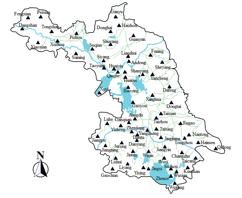
Jiangsu province has undergone several adjustments in its administrative divisions in modern times. This study utilizes the administrative map of Jiangsu province in 1949 as a base, aligning the historical locations of DFD with the administrative map of Jiangsu province in 1949. Moreover, regions currently outside the administrative scope of Jiangsu are excluded from this study (Fig. 1).
Data Collection
Jiangsu has historically been a region prone to frequent disasters. A substantial corpus of records detailing the occurrence of disasters and the responses of the people is preserved in historical documents. In this study, the data was primarily collected from local chronicles of Jiangsu from the Qing dynasty to the Republic of China, specifically between the years 1840 and 1948. Additionally, this study includes a series of local chronicles compiled by the editorial committee of Jiangsu province's cities and counties after the establishment of the People's Republic of China. Moreover, the data was further refined and augmented, referring to other collections of historical documents. Notable sources include the Jiangsu Volume of the Chinese Meteorological Disaster Canon [38], the General Collection of Meteorological Records in China for the Past 3000 Years [39], the General Collection of Abnormal Chronology and Major Natural Disasters in Ancient China [40], the Continuation of Disaster Annals in Recent China (1919-1949) [41], etc. From these documents, a total of 1067 records of drought and flood disasters in the Jiangsu region from 1840 to 1948 were obtained. The entire dataset comprises 430 records of drought disasters and 637 records of flood disasters.
Wavelet Analysis
Wavelet analysis is a powerful technique for effectively distinguishing between the high-frequency and low-frequency components in disaster records [42]. The low-frequency component reflects the overarching development trends and periodic behaviors within the data, while the high-frequency component captures instances of sudden and abrupt events. In this study, the Morlet wavelet’s structure is selected as the generating function of the wavelet. Specifically, the Morlet wavelet transform is characterized by a mono-frequency complex sine wave modulated by a Gauss curve, offering superior localization properties in both time and frequency domains. This duality makes the Morlet wavelet particularly effective for analyzing non-stationary data where preserving the temporal dynamics of disaster records is crucial. The mathematical expression for the Morlet wavelet is as follows:
where ω0 is the dimensionless frequency, i denotes the imaginary unit, and t is the non-dimensional phase difference. This formulation highlights the wavelet’s dual nature, combining a complex exponential function for frequency representation with a Gaussian envelope to manage localization in time.
The discrete expression for the wavelet transform of a signal f(t) in the real-value field can be formulated as follows:
where a represents the scale factor, b is the translation factor, ∆t denotes the sampling interval, and N is the total number of records. The function ψ(·) is the wavelet function. This formulation allows the wavelet transform to capture both time and frequency characteristics of f(t) by jointly adjusting a and b.
The wavelet power spectrum E, which quantifies the energy distribution of a signal across different scales and translations, can be defined as:
The total wavelet power spectrum, which aggregates the power across all translations at a specific scale, can be expressed as:
where the subject is n-0,1,···,N-1.
Geographically Weighted Regressions
Geographically weighted regression (GWR) is an innovative methodology designed to address the issue of non-stationary within spatial models by allowing for local variations in the parameters of the regression model [43]. This adaptability significantly enhances the goodness of fit of the model. The GWR model, an extension of traditional regression analysis, is increasingly employed in spatial analysis and modeling of geographical data. Notably, its parameters are functions of spatial position, denoted as $i$, and the parameters will adapt in response to changes in this position. The GWR model can be expressed as:
where (ui,υi) is the spatial coordinates of the ith sample point, xik is the kth independent variable of the ith sample point, ai0(ui,υi) and aik(ui,υi) are the intercept and the slope parameters for the ith sample point, respectively. P denotes the number of independent variables, and εi is the error term that accounts for model discrepancies at the ith location.
Results
Temporal Distribution Characteristics of DFD
Fig. 2 illustrates the annual frequency records of DFD in Jiangsu province from 1840 to 1948. Over this 109-year period, drought disasters were recorded in 83 of those years, and the number of counties influenced by drought disasters reached the highest in 1856, when drought disasters happened in 43 counties. Additionally, the years 1842, 1924, and 1934 each saw more than 20 counties experiencing drought disasters, while the remaining years documented fewer than 20 affected counties. In terms of flood disasters, they were recorded in 98 years within the same period from 1840 to 1948. Notably, the number of counties affected by flood disasters all exceeded 20 in 1848-1849, 1874, 1906, 1921, and 1931, especially 1931 marked the peak with 47 affected counties. The trend analysis reveals that during the period from 1924 to 1935, the frequency of counties experiencing drought disasters in Jiangsu was generally higher compared to other years. Meanwhile, the number of counties affected by flood disasters was consistently higher than that affected by drought disasters.
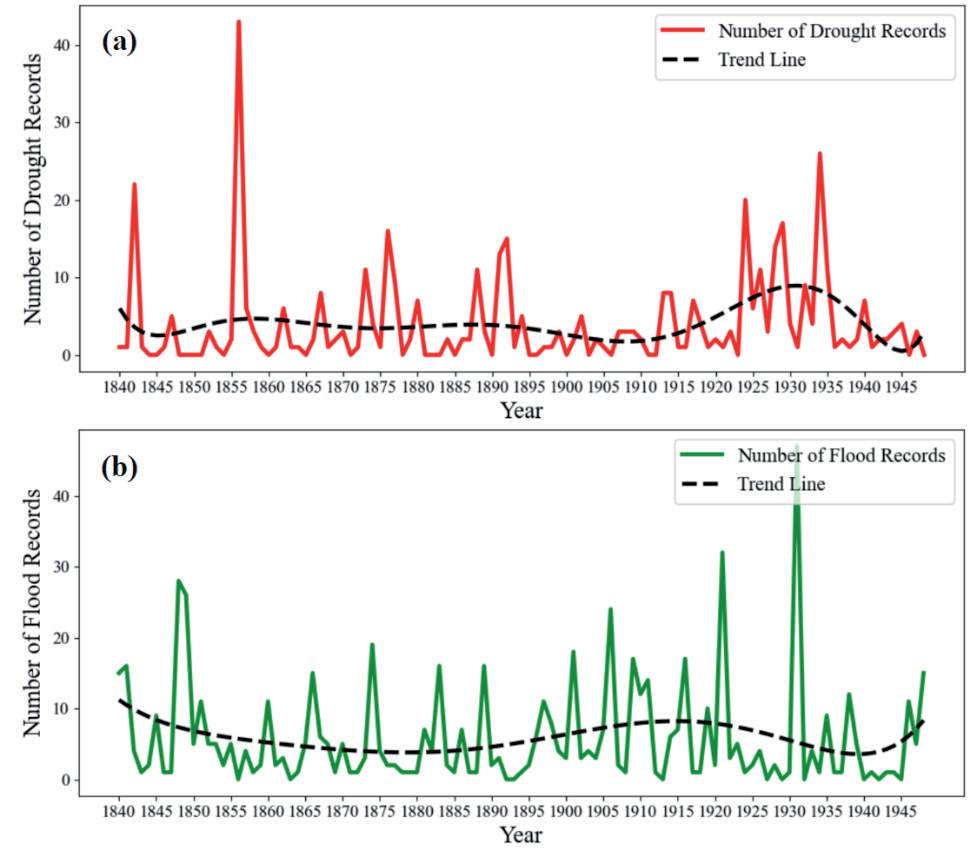
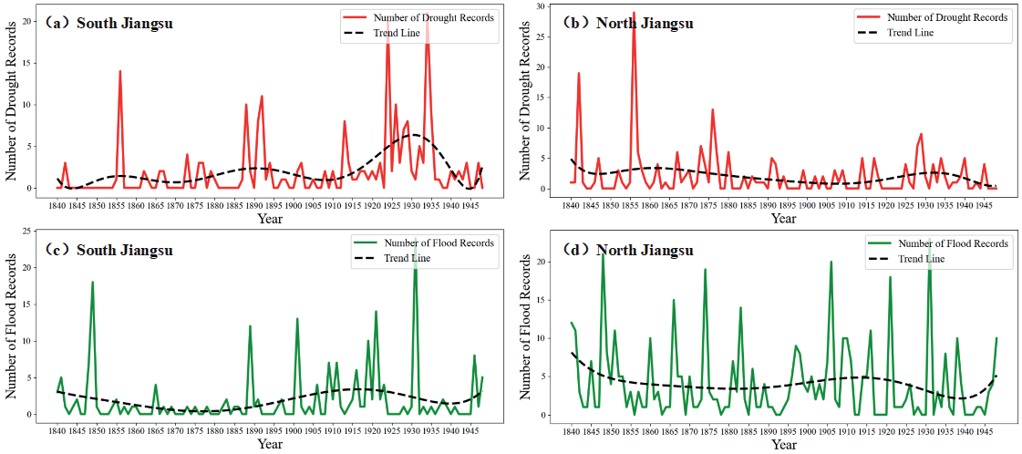
Fig. 3 depicts the difference in DFD between the southern and northern regions of Jiangsu province. As shown in Figs. 3(a) and 3(b), the drought disaster in 1856 had a great negative influence on the whole Jiangsu province. Conversely, the drought disasters occurring between 1924 and 1935 have a greater influence on the southern areas of Jiangsu province. Furthermore, Figs. 3(c) and 3(d) illustrate that the number of flood disaster frequencies of flood disasters in southern Jiangsu is fewer than that of the north between 1850 and 1888. Overall, the northern area of Jiangsu experienced a generally higher frequency of flood disasters throughout the study period, exceeding that of the southern region.
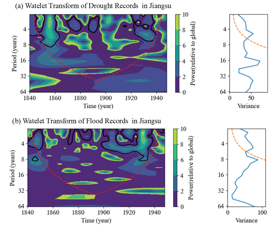
To further study the temporal characteristics of the DFD in Jiangsu province in modern times, the wavelet analysis method is adopted in this study. Fig. 4 presents the wavelet power spectrum and global wavelet spectrum for the overall frequency of DFD. In the power spectrum, the areas enclosed by the black contour line have passed a 95% significance test. The red conical lines denote the cone of influence, and the grid area above these lines is the area affected by boundary effects. Boundary effects at both ends of the time sequence might be produced, for which the measured data is data sequence within finite time. The global wavelet spectrum, indicated by the yellow dotted line for the 95% significance level, reflects the distribution of fluctuation energy across periods in the time series and is useful for identifying predominant cycles in the evolutionary process. As depicted in Fig. 4(a), for drought disasters, there is an oscillation period of approximately 8 years around 1860 and a fluctuation period of roughly 4 years from 1870 to 1880 and around 1890. Between 1920 and 1940, significant periods of 4 years and 8 years are observed, indicating that these cycles may contribute remarkably to the frequent occurrence of droughts. The global wavelet spectrum reveals a peak significant period of approximately 5 years for the overall drought frequency in Jiangsu province. Fig. 4(b) illustrates the wavelet analysis results for flood disasters, showing that there is a significant oscillation period of approximately 6 years before 1850, a significant cycle shorter than 4 years around 1870- 1890, and a periodical temporal characteristic of 2 to 10 years around 1900-1940. In addition, there is an obvious peak around 1 year and 6 years in the spectrum and also an insignificant peak around 9 years.
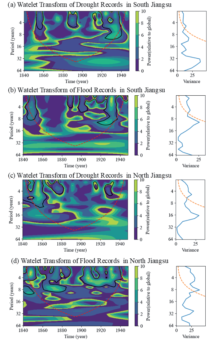
Fig. 5 illustrates the inter-annual variability and temporal frequency characteristics of DFD in the southern and northern regions of Jiangsu from 1840 to 1948. As shown in Fig. 5a), the power spectrum results indicate that the frequency of drought disasters in the southern region of Jiangsu Province exhibits a significant cycle of approximately 2-4 years around 1860, approximately 4 years cycles around 1880- 1890, and less than 10-year cycle during 1920-1940. The global wavelet spectrum reflects a significant periodicity of approximately 5 years in drought disaster occurrences in the southern region. As shown in Fig. 5(b), flood frequencies in the southern region show cyclical patterns of 2-8 years prior to 1860, cycles shorter than 4 years between 1880 and 1920, and a cycle of approximately 8 years from 1920-1940. The global wavelet spectrum indicates that there is a significant period of approximately 1 year and 6 years in flood disaster frequency in the southern region and also a peak at approximately 10 years, but it is not significant.
The results for the northern region of Jiangsu province differ slightly from those of the southern region. As shown in Fig. 5(c), wavelet analysis of drought disaster frequencies in the northern region indicates that there were significant 6-year cycles before 1860 and an approximately 4-year oscillation period around 1880 and 1930. The global wavelet spectrum for the period 1840- 1948 shows that there is a significant peak with a period of approximately 5 years in the northern region of Jiangsu province from 1840 to 1948, which is consistent with the overall results for the southern region. As shown in Fig. 5(d), the wavelet analysis of flood disaster records in the northern region reveals significant cycles of about 4 years before 1850, approximately 9-year periodic fluctuations between 1860 and 1880, and approximately 8-year periods during 1900-1940. The global wavelet spectrum exhibits a significant period of approximately 8-year cyclical peak in flood disaster records in the northern region.
Spatial Distribution Characteristics of DFD
By establishing the local regression equation at each point within the spatial range, this method enables the exploration of the spatial changes of the research object at a certain scale and related driving factors. Fig. 6 presents the distribution of disaster records for different seasons across the counties in Jiangsu province from 1840 to 1948. As shown in Fig. 6(a) and 6(d), during the spring season, several counties in Jiangsu province, including Gaoyou, Jiangning, Suqian, Xinghua, and Wujin, etc., experienced a notable frequency of DFD, while the rest of the counties had a lower incidence of disasters. In general, Jiangsu province experienced fewer drought and flood disasters in winter, as shown in Fig. 6(e) and 6(h), with few records indicating occurrences of both types of disasters during this season. In contrast, as shown in sub-Figs. (b), (c), (f), and (g) in Fig. 6, the frequency of DFD in Jiangsu province significantly increased during the summer and autumn seasons within the time period studied in this paper. In summer, Wujin experienced 19 drought disaster occurrences, while Xinghua, Yixing, Jiangning, and Gaoyou experienced more than 10 drought events as well. Regarding drought disasters, the frequency in autumn was lower than that in summer. Records show that only Jiangning experienced 15 drought disasters in the autumn, while the other counties experienced fewer than 10 drought events. As shown in Figs. 6(f) and 6(g), it can be observed that the frequency of flood disasters during the summer is the highest. Among them, 10 counties, including Gaoyou, Jiangdu, Jiangning, etc. experienced more than 10 flood disasters. Although the frequency of flood disasters during autumn was relatively lower compared to summer, Gaoyou still recorded 18 instances of flood disasters.
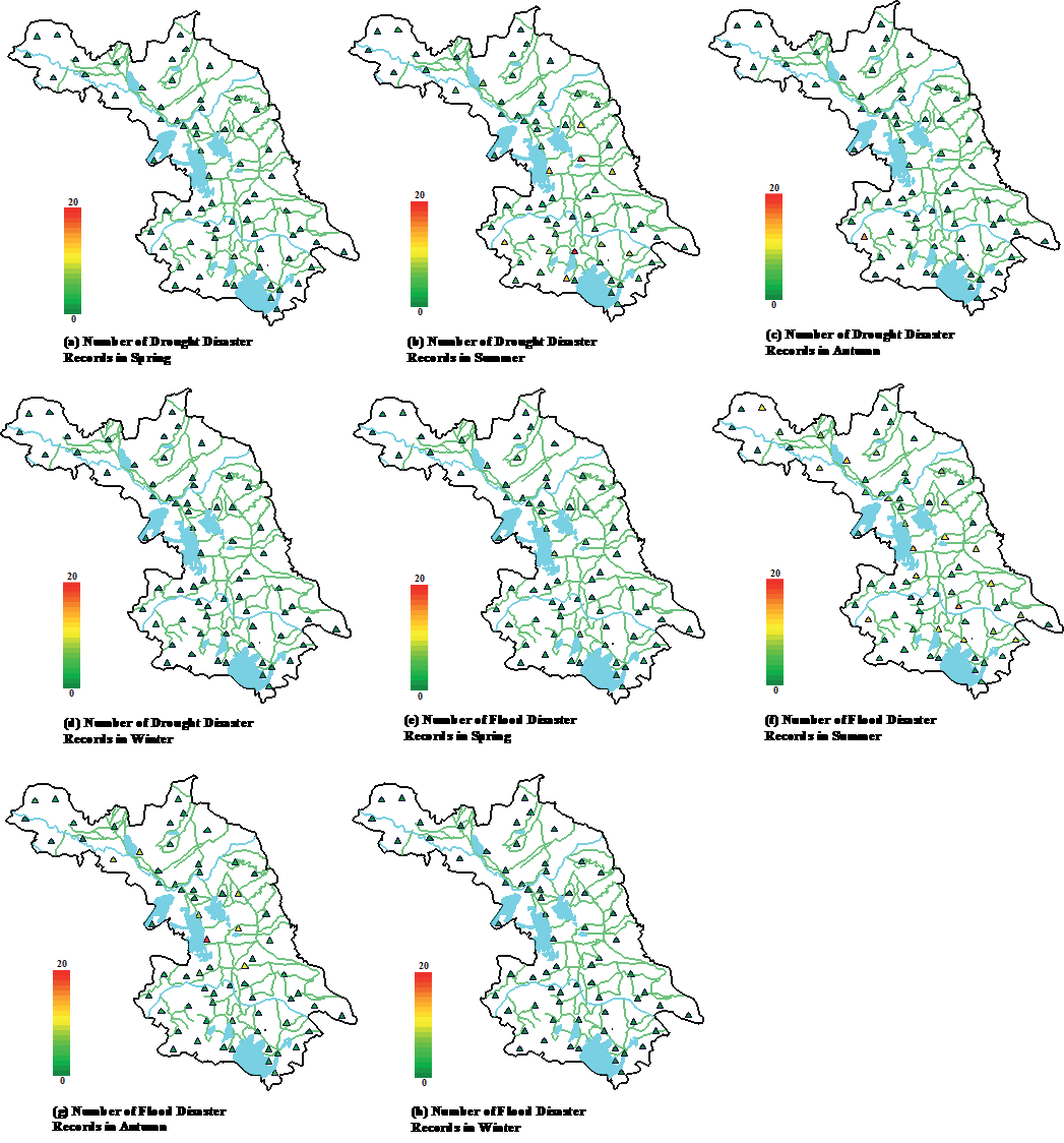
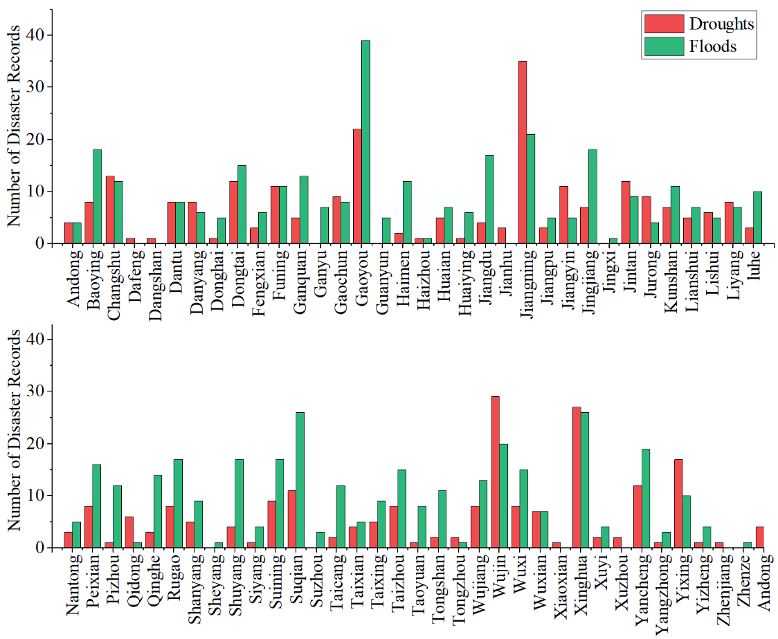
Fig. 7 presents the frequency of disaster records across different counties in Jiangsu from 1840 to 1948. It can be observed that the frequencies of DFD are different in different counties. Notably, counties like Gaoyou, Jiangning, Suqian, Wujin, and Xinghua experienced a significantly higher frequency of disasters compared to other counties. In contrast, counties such as Dafeng, Dangshan, Jingxi, Sheyang, Xiaoxian, and Zhengze recorded comparatively fewer disasters. Overall, most counties show fluctuations around approximately 10 occurrences in total for both droughts and flood disasters.
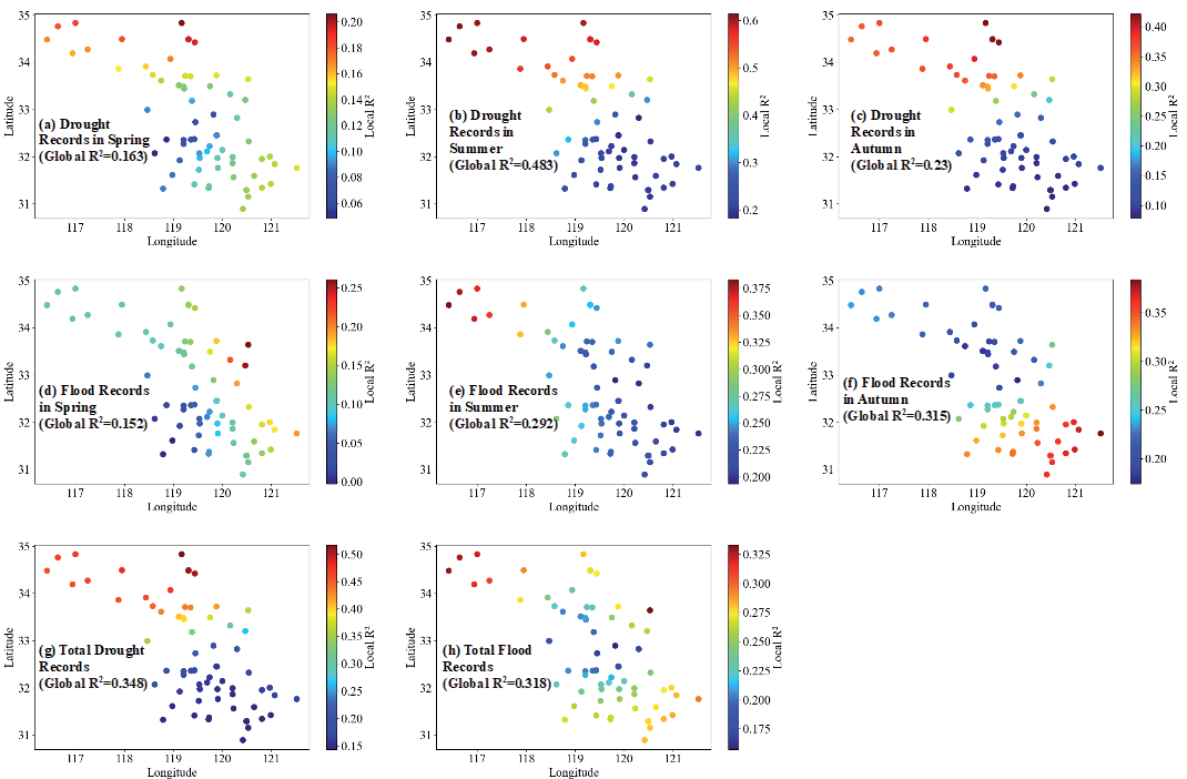
Using the 68 counties of the research area as subjects, GWR was applied based on the frequency data of DFD in spring, summer, autumn, and overall, in relation to the longitude and latitude of the counties. Considering the very few disaster records during the winters between 1840 and 1948, this study omits the geographically weighted modeling of such data. Fig. 8 presents the GWR results of DFD in Jiangsu based on the GWR model. It can be seen that the model produces a total of 68 results of local recurrent, each corresponding to one of the studied counties. For drought disasters, as shown in Fig. 8 (a, b, c, g), the northern region of Jiangsu shows a higher R2 value between the frequency of drought disasters and longitude and latitude, indicating a stronger correlation. In contrast, the southern region shows a lower correlation between drought disasters and geographical coordinates. Moreover, the global value of R2 between the summer drought disaster frequency and the latitude and longitude is 0.483, and for autumn, it is 0.23, which is higher than the 0.163 in spring. This suggests that the overall correlation between drought disaster records and the geographic location of counties is stronger in summer and autumn compared to spring. As for flood disasters, illustrated in Fig. 8 (d, e, f, h), the global R2 for spring is 0.152, indicating a lower correlation. The local R2 values are higher in the northern region during summer and higher in the southern region during autumn, demonstrating that the correlation between flood disasters and geographic location in Jiangsu is seasonally variable.
Discussion
Causes of DFD in Modern Jiangsu
In modern times, Jiangsu province has frequently suffered from severe DFD, resulting in tremendous losses. The causes of these disasters are diverse, encompassing both natural and socio-political elements [44]. Nevertheless, the primary cause is indisputably linked to the unique geographical and environmental background of the region.
Jiangsu faces the Pacific Ocean on the east and is marked by a pronounced ocean and monsoonal climate. Anomalies in atmospheric circulation are one of the main factors influencing abnormal precipitation patterns in Jiangsu province. Annually, Jiangsu is successively influenced by the plum rain season and summer drought phenomena, with precipitation showing regular variations from south to north and from the coast to the interior [45]. When the air mass of plum rain advances northward and encounters the northern cold high-pressure systems, sustained and concentrated precipitation will be formed, which frequently results in flood disasters. Conversely, if the air mass of plum rain moves northward without encountering cold high pressure, the weather remains sunny and less rainy, thus usually causing drought disasters.
Moreover, the seasonal distribution characteristics of precipitation are obvious in Jiangsu due to the influence of the monsoonal climate [46]. In spring, the precipitation throughout the province significantly increases affected by the interaction of cold and warm air masses, particularly in southern Jiangsu. In summer, the southeast monsoon prevails, bringing the most plentiful precipitation of the year. In autumn, the transition from summer to winter monsoons leads to a gradual reduction in precipitation. In winter, Jiangsu experiences the least precipitation under the influence of the winter monsoon. Additionally, this modern time is the fourth cold period in the climatic fluctuation cycle since 5000 B.P. in China. Especially, various disasters converged during the late Qing Dynasty and the beginning of the Republic of China. Therefore, exceptional climate factors are a significant contributor to the DFD. In addition, the unique geological and geomorphological features of Jiangsu make it susceptible to natural disasters [47]. Jiangsu, with abundant rivers and lakes, is situated along major waterways and the coast, frequently experiencing upstream water flows that lead to flood disasters. The long-term impact of the Yellow River diverting the Huaihe River's course to the sea, along with silt accumulation in the lower reaches of the Huaihe River, diminished the drainage capacity and intensified the risk of flood disasters.
Famine is not only a natural phenomenon but also a social phenomenon. In modern Jiangsu, the province became a strategic military focal point during periods of revolution contended by northern and southern forces. Intentional dike blasts for military objectives were one of the primary anthropogenic causes of flood disasters. For instance, in 1938, Jiang Kai-shek ordered the blasting of the southern embankment of the Yellow River to impede the Japanese military advance, leading to widespread flooding. Besides, other factors, such as official corruption, rapid population growth, and unsustainable exploitation of natural resources, exacerbated the severity and frequency of DFD disasters [48].
Socioeconomic Impact of DFD on Modern Jiangsu
Jiangsu province, with its advantageous geographical position, has been a vital agricultural and commercial center in China since ancient times. The frequent occurrences of DFD have severely threatened and damaged the socioeconomic stability and the well-being of the people.
On one hand, drought and flood disasters have damaged the rural economy. DFD caused significant reductions in crop yields and, in some cases, complete crop failure, which usually resulted in grain shortages and consequent price surges [49]. Furthermore, the impact of these disasters often deprives farmers of their economic livelihood, rendering them unable to purchase necessary food supplies. Under such circumstances, survival becomes challenging, leading to mass casualties, labor shortages, extensive tracts of unattended farmland, and considerable direct and indirect economic losses.
On the other hand, drought and flood disasters have contributed to substantial population displacement and social turbulence [50]. Obviously, the disasters caused numerous fatalities. Indirectly, the ensuing crop failures often bring about famines, compelling large numbers of people to migrate in search of better living conditions. This migration drastically reduced the local population. Those who migrate to other areas may engage in land reclamation or turn to handicrafts for a better livelihood. However, some of these displaced individuals may resort to theft, begging, or prostitution, engendering various social maladies and adversely affecting social order and stability.
Conclusions
Drought and flood disasters are the most prevalent and severe natural disasters in Jiangsu. In this study, DFD of Jiangsu Province from 1840 to 1948 in historical records was meticulously collected and analyzed. Moreover, wavelet analysis and GWR were adopted to study the temporal and spatial distribution characteristics of DFD. The conclusions are as follows:
In modern times, Jiangsu experienced 1,067 drought and flood disasters, comprising 430 drought disasters and 637 flood disasters. Flood disasters were more frequent than drought disasters, occurring alternately with droughts. DFD predominantly occurred during the summer and autumn, with the occurrence of DFD for three and even four consecutive seasons. With respect to droughts, there were significant cyclical patterns: around 1860, there were significant cycles of approximately 8 years, and between 1920 and 1940, there were significant cycles of 4 and 8 years observed, with an overall peak cycle of five years for droughts' frequency. For flood disasters, significant cycles were identified, and there was a cycle of approximately 6 years prior to 1850, about 4 years between 1870 and 1890, and cycles ranging from 2 to 10 years from 1900 to 1940.
Regarding spatial distribution characteristics, the distribution of DFD in modern Jiangsu exhibited clear regional differences. The drought disasters were primarily concentrated in counties such as Gaoyou, Jiangning, Suqian, Wujin, and Xinghua. For drought disasters, the frequency was comparably high in both southern and northern Jiangsu, with counties like Wujin, Xinghua, Yixing, Jiangning, and Gaoyou experiencing more frequent drought disasters. In contrast, the northern region suffered more frequently from flood disasters, especially in counties like Gaoyou, Jiangdu, and Jiangning.
In terms of the causes of DFD in modern Jiangsu, natural factors were predominant, including abnormal climate, unique hydrological features, and geographical factors. Socio-political factors, such as military purposes, bureaucratic corruption, and population growth, also played significant roles.
The socio-economic impacts of DFD in modern Jiangsu were profound, including the devastation of rural socio-economic structures, significant population displacement, and considerable disruption of social order.

