

Introduction
According to the document titled “The Well Facilitated Farmland Construction-General rules (GB/T 30600-2022),” issued by the State Administration for Market Regulation, well-facilitated farmland refers to farmland that is flat, concentrated, and contiguous, with complete facilities, water-saving and efficient features, access to electricity, suitable for machine operation, having fertile soil, ecologically friendly, and highly resistant to disasters. Such farmlands are well-suited for modern agricultural production and management methods, including drought and flood protection, and are known for their stability and high yields. With the rapid industrialization and urbanization of China, a significant amount of high-quality farmland has been occupied. Additionally, the level of agricultural modernization has remained relatively low, and the utilization and management of farmland also face challenges. Some regions in China are experiencing declining farmland quality and unsustainable increases in yield. Moreover, concerns regarding food and ecological security are becoming increasingly more prominent. In light of the limited scope for expanding cultivated land, building well-facilitated farmlands and shifting from a focus solely on quantity-centered cultivated land protection to an equal emphasis on quantity and quality are crucial steps in strengthening China’s food security. These measures will promote agricultural modernization and enhance the overall quality, quantity, and ecological management of farmlands.
As of 2020, China has successfully constructed 800 million mu of well-facilitated farmlands. The National Well-facilitated Farmland Construction Plan (2021–2030) issued in 2021 aims to build 1.2 billion mu of well-facilitated farmland by 2030, with large construction projects currently underway. However, due to the lack of comprehensive planning for the construction of well-facilitated farmland, progress has been somewhat haphazard, resulting in issues such as inadequate coordination of construction timelines and underutilization of funds in certain areas. To address these challenges, it is essential to establish methods for constructing well-facilitated farmland in the right locations, at the right time, and in the right manner, which is a practical problem faced by many regions in China. In the face of these challenges, the importance of scientific planning cannot be understated.
In recent years, numerous scholars have conducted extensive and in-depth research on the suitability evaluation criteria and zoning methods for well-facilitated farmland construction. Theoretical research in this area has focused on well-facilitated farmland models, spatiotemporal layout, temporal arrangement, obstacle factor diagnosis, empirical analysis, and other aspects [1-5]. Current research on evaluation methods primarily centers on the improved catastrophe series model, the TOPSIS method, the four-quadrant method, the entropy method, and spatial autocorrelation analysis [6-9]. However, there has been insufficient research from an overall regional perspective, particularly with a focus on landscape ecology, and therefore the ecological value of farmlands has been largely overlooked. Moreover, the subjective biases present in previous evaluation models have influenced the evaluation factors and, to some extent, affected the scientific rigor of the evaluation results. Additionally, the previous evaluation model failed to assess each plot as a unit and was therefore not accurate enough to guide actual project development. To address these gaps, our study aims to develop an ecological niche model based on clear ecological endpoints for the planning and evaluation of well-facilitated farmland construction.
In our study, we placed greater emphasis on ecological factors, such as biodiversity and heavy metal pollution. Furthermore, our analyses were conducted with each plot as the evaluation unit and the basic principles of niche theory were fully applied in the evaluation process. We specifically focused on the Fengxiang District in Baoji City, and the multi-dimensional super volume ecological niche theory was innovatively applied for the zoning of well-facilitated farmland construction in Shaanxi. To achieve this, we developed a suitability evaluation system and obstacle factor diagnostic model, which couples obstacle degrees with ecological niche suitability factors. Through this model, we qualitatively identified and quantitatively diagnosed the obstacle factors that impact the construction of well-facilitated farmlands. By considering the difficulty of transforming obstacle factors alongside the suitability of construction, we designated priority areas for construction. This comprehensive approach provides a scientific foundation and serves as a reference for effectively zoning and constructing well-facilitated farmland not only in Shaanxi but also in other regions across China. Collectively, our research results can contribute to the green and sustainable development of agriculture on a global scale.
Materials and Methods
Study Area
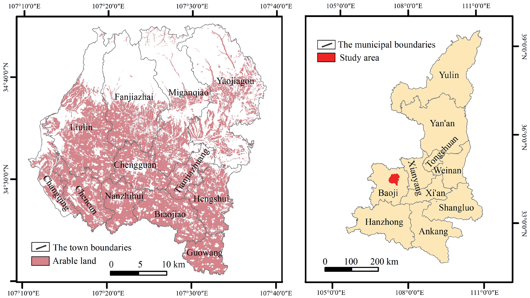
Baoji City is located in the western part of the Guanzhong Plain. This city falls under the jurisdiction of Shaanxi Province and is a sub-central city within the Guanzhong Plain Urban Agglomeration. The specific research area, Fengxiang District, is located in the northeast of Baoji City, covering an approximate total area of 1179 km2. The geographical coordinates of the study site range from 34°20′44″ to 34°45′27″N and from 107°10′30″ to 107°38′09″E (Fig. 1). Within this region, there are 12 towns and 160 administrative villages, with a permanent population of 379,000 as of the end of 2021. The northern part of Fengxiang District is characterized by hilly and mountainous terrain, with altitudes ranging from 1200 to 1600 meters. The geological composition consists of red bottom conglomerate and Hipparion red soil. In contrast, the southern part features a fertile plain with elevations ranging from 649 to 968 meters. Fengxiang District experiences a warm temperate continental monsoon climate, with a semi-humid and semi-arid environment. The average annual temperature is 11.4°C, and the region receives an average annual precipitation of 625 mm. The frost-free period lasts 209 days and the area experiences four distinct seasons, with extended winters and summers and relatively shorter spring and autumn periods. As of the end of 2019, the cultivated land area in Fengxiang District measured 569.18 km2, of which paddy fields accounted for only 0.01% of the total, whereas irrigated land and dry land constituted 65.23% and 34.76% of the total area, respectively.
Data Source and Processing
To ensure that the suitability evaluation of well-facilitated farmland construction was conducted in a scientifically robust, practical, and convenient manner, the findings of our study were applied to specific farmland plots. These farmland plots were used as the fundamental unit for evaluation, and the necessary farmland maps were directly extracted from the farmland resource quality classification database of Fengxiang District, Baoji City. In total, there were 20,669 farmland patches considered for evaluation. The suitability evaluation involved the use of various databases containing crucial information such as effective soil layer thickness, topsoil texture, salinization degree, organic content, drainage conditions, irrigation guarantee rate, slope gradient, and irrigation water source, among other relevant factors. These data were sourced from the 2019 cultivated land resource quality classification database, and cultivated land patches served as the basic unit of evaluation. Additional biodiversity and heavy metal pollution data were primarily obtained from the results of sampling and analysis conducted in the area. To complement the assessment, factors such as the distance from the main road, the degree of farmland contiguity, the field scale, the landscape index, and the patch shape index were calculated based on the actual conditions of each farmland patch.
Definition of the Ecological Niche of Well-Facilitated Farmland
In 1924, Grinnell [10] first defined “ecological niche” and introduced the concept of “spatial ecological niche.” Since then, prominent ecologists such as Elton [11], Hutchinson [12], Whittaker [13], Odum [14], and Leibold [15] have expanded upon the ecological niche theory, leading to continuous development and deepening of its connotations and denotations. Some researchers have also applied this theory to land consolidation and well-facilitated farmland construction planning [1, 16-19]. The ecological niche theory establishes that from individual organisms to the entire biosphere, both natural and social biological units possess the characteristics of ecostate and ecorole. Well-facilitated farmland represents a complete ecosystem that not only demands high and stable yields but also requires strong ecological support for sustainable farmland use [20-22]. Therefore, when determining the ecological niche of well-facilitated farmland, it is essential to consider not only the state of the farmland itself but also its impact on the surrounding environment [18].
Table 1.
Evaluation system for well-facilitated farmland construction suitability.
Our study adopted the principles of the ecological niche theory to establish a multi-dimensional evaluation system for assessing the suitability of well-facilitated farmland construction. This involved comparing realistic ecological niches against ideal ecological niches to gauge the level of suitability for construction. Additionally, we introduced an obstacle factor diagnostic model to analyze the factors that hinder the construction of well-facilitated farmlands. By combining suitability, obstacle degree, and transformation difficulty, we ranked the areas from favorable to unfavorable and from easy to challenging for construction. Based on these evaluations, we developed differentiated construction and control strategies, providing criteria for defining priority areas for well-facilitated farmland construction.
Establishment of the Evaluation Model
Construction of Suitability Evaluation Model
To comprehensively assess the impact of soil conditions, infrastructure construction, landscape patterns, and ecological constraints on ecological niche suitability, our study adhered to the principles of scientificity, comprehensiveness, operability, and diversity to construct an evaluation index system (Table 1). Initially, based on existing research and techniques, evaluation factors such as effective soil layer thickness, topsoil texture, and salinization degree were identified. Similar factors were then combined to form a well-facilitated farmland construction suitability evaluation system comprising 4 dimensions and 15 factors. These factors include discrete indicators such as topsoil texture, salinization degree, drainage conditions, irrigation guarantee rate, biodiversity, heavy metal pollution, and irrigation water sources, among others. To facilitate data quantification, we categorized the discrete factors through grading by referring to established guidelines such as the “Outline of Land Evaluation” and the “1:100000 Land Resource Evaluation System” in China. Other continuous indicators were calculated using the ecological niche suitability evaluation model mentioned earlier and standardized via the extreme value method (Table 2).
The optimal value for well-facilitated farmland construction is influenced by multiple factors. According to the ecological niche model and relevant research [2- 13], the factors related to construction suitability can be categorized into three types: positive, moderate, and negative factors. For positive factors, where larger values indicate more favorable resource conditions, the maximum value of the standardized extreme value was taken as the optimal value. Moderate factors possess an optimal interval and encompass regional factors. Thus, we selected the standardized average of the extreme values as the optimal value. Conversely, for negative factors, smaller values indicate better resource conditions, and we selected the minimum value of the standardized extreme value as the optimal value. The calculation methods for these three types of evaluation factors can be found in Zhao et al. [1] and Zhao et al. [18].
Table 2.
Evaluation score table of discrete factors of wellfacilitated farmland construction.
Table 3.
Zoning standard and type combination of well-facilitated farmland construction.
Ecological niche suitability refers to the degree of fitness of species to their habitat conditions, which measures the proximity between the ecological niche of biological resources and the ideal ecological niche. When actual resource conditions align with the species’ needs, ecological niche suitability approaches 1. Conversely, if it is close to 0, the ecological niche suitability value falls within a range of 0 to 1. As the ecological niche of well-facilitated farmland construction consists of an n-dimensional resource space comprising multiple factors, any inadequacy in the evaluation factors will affect its suitability. For detailed calculation methods on ecological niche suitability, please refer to Zhao et al. [1].
Construction of Obstacle Factor Diagnostic Model
Identifying and assessing the primary obstacles to well-facilitated farmland construction in the affected area can significantly contribute to the success of targeted remediation projects or even lead to the complete elimination of these obstacles. In our study, the obstacle degree refers to the level of influence exerted by each dimension factor on the construction of well-facilitated farmland. According to the bucket law, the key factor that restricts the construction of well-facilitated farmland is the factor with the poorest ecological niche suitability. To diagnose the obstacle factors of well-facilitated farmlands, we utilized the ecological niche suitability factor and the obstacle factor diagnostic model (Qi). The calculation formula for each evaluation factor in the obstacle model can be found in Zhao et al. [1].
Zoning Method for Well-Facilitated Farmland Construction
The construction of well-facilitated farmland involves not only selecting suitable plots but also considering factors such as easy transformation of obstacle factors, low construction costs, and high efficiency. Therefore, during site selection, priority is given to areas with favorable construction suitability and minimal obstacles, along with factors that are easy to transform. Based on the results of the suitability evaluation, our study comprehensively assessed the difficulty of obstacle factors and their transformation, leading to the formulation of zoning rules and the delineation of well-facilitated farmland construction areas.
Transforming or eliminating obstacle factors through renovation projects is essential to improve the suitability of farmland construction. However, given the variation in the difficulty of transforming these factors, remediation efforts must be conducted from easier to more challenging scenarios to maximize benefits and minimize costs. After years of well-facilitated farmland construction, the difficulty levels of different scenarios were categorized based on 4 dimensions and 15 factors. For instance, in the soil condition dimension, effective soil layer thickness, topsoil texture, and salinization degree are factors that are difficult to transform compared to organic content. In the infrastructure construction dimension, drainage conditions, distance from the main road, and irrigation guarantee rate are easier to modify and upgrade. In the landscape pattern dimension, factors such as farmland contiguity, field scale, landscape index, and patch shape index are relatively easy to transform. In the ecological constraints dimension, irrigation water sources are easier to transform, whereas biodiversity, slope gradient, and heavy metal pollution are more challenging to address (Table 3).
The suitability of well-facilitated farmland construction is divided into five levels represented by Roman numerals I to V, with the highest suitability corresponding to level I areas. Building on the obstacle factor diagnostic model developed earlier, obstacle levels are divided into four categories: level 1, level 2, level 3, and level 4. Level 1 indicates the highest impact of a specific factor on the construction of well-facilitated farmland, followed by level 2, and so on. With these considerations, a well-facilitated farmland area delineation method was created, incorporating suitability, obstacle degree, and difficulty level. For instance, the combination code “I-3-Y” indicates that the plot has high construction suitability, some obstacles, and low difficulty in transforming the obstacle factor. In other words, if a plot is spatially suitable for construction and has no significant and difficult obstacle factors, it becomes a priority construction area. There are 40 potential combination methods based on type combination. However, only 24 combinations were identified in Fengxiang District, Baoji City. The specific combination types are illustrated in Table 4.
Results and Discussion
Suitability Evaluation Results of Well-Facilitated Farmland Construction
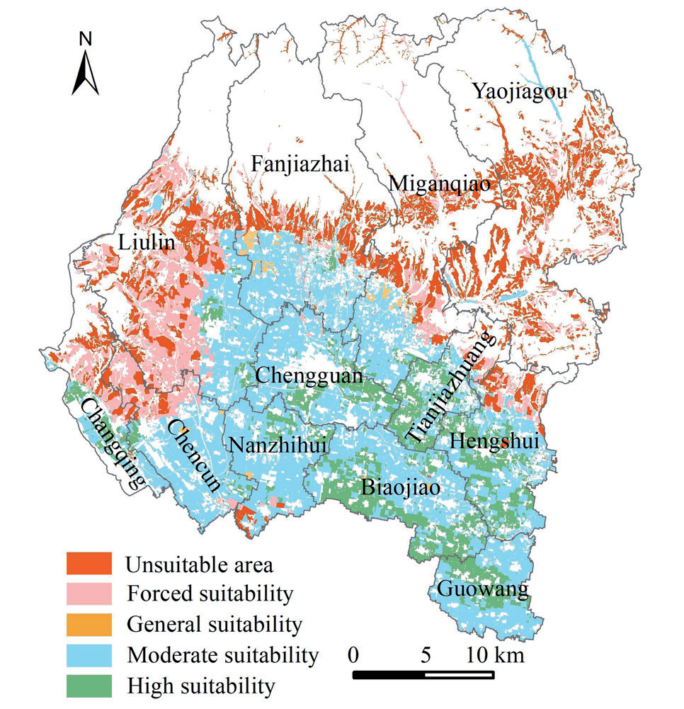
Fig. 2 presents the suitability evaluation results of well-facilitated farmland construction in Fengxiang District. As illustrated in Fig. 2 and Table 5, the level I area exhibits high suitability, covering approximately 84.46 km2, accounting for 14.84% of the total cultivated land area. In this region, there are 2990 patches that gradually meet the conditions for well-facilitated farmland construction. The majority of this area is concentrated in the southeast of Fengxiang District, specifically in locations such as Chengguan Town, Tianjiazhuang Town, Biaojiao Town, Hengshui Town, and Guangang Town. The terrain in this area is primarily flat, with less than 2° covering 94.65% of the region. The soil is fertile, and all cultivated land is effectively irrigated. Moreover, 95.23% of the area has an effective soil layer thickness greater than 100 cm, the organic matter content of 99.65% of the area exceeds 10g/kg, 99.93% of the surface soil texture is classified as loam or clay, and 99.72% of the area can fully or largely meet the irrigation guarantee rate. The farmland is highly contiguous, suitable for mechanized cultivation, and free from soil pollution or salinization.
The level II area represents medium suitability, covering approximately 271.99 km2, which accounts for 47.79% of the total area. Within this region, there are 9746 patches that exhibit certain limiting factors but can meet the construction conditions for well-facilitated farmland with slight improvements. The largest area is primarily distributed in the central and southern plain areas. The terrain in this region is predominantly flat, with slopes ranging from 2° to 4° in 99.14% of the area. The effective soil layer thickness is primarily 60, 100, and 110 cm. Additionally, 99.63% of the surface soil texture is categorized as loam or clay and 95.88% of the soil has an organic matter content that exceeds 10 g/kg. The soil is fertile, and all cultivated land is irrigated. Approximately 75.21% of the area can fully or largely meet the irrigation guarantee rate, and 34.39% of the irrigation water source is surface water or shallow groundwater.
Table 4.
Zoning standard and type combination of well-facilitated farmland construction.
Table 5.
Suitability grading results of the well-facilitated farmland construction.
The level III area corresponds to a generally suitable area, covering approximately 5.06 km2, which accounts for 0.89% of the total area. There are 789 patches in this region, with 1 to 2 high limiting factors. Targeted remediation measures are necessary to meet the conditions for well-facilitated farmland construction. This area is primarily concentrated in the southern part of Fanjiazhai Town and Miganqiao Town. The effective soil layer thickness is relatively small, with only 10.47% of the area having an effective soil layer thickness greater than 100 cm. Approximately 26.88% of the area can fully or largely meet the irrigation guarantee rate, and 86.76% of the area is irrigated by deep groundwater. The terrain is flat, with 95.26% of the area having a slope between 2° to 4°.
The level IV area represents the barely suitable area, covering approximately 86.89 km2, which accounts for 15.27% of the total area. There are 2666 patches in this region, but it lacks the necessary conditions for building well-facilitated farmland. This area is mainly concentrated in the western and eastern regions, particularly in the southern part of Liulin Town, the northern part of Chenchun Town, and the northern part of Changqing Town. Numerous limiting factors exist in this area, with significant ground fluctuations, and 54.52% of the area has a slope exceeding 10°. The soil quality is poor, with only 46.78% of the area having an effective soil layer thickness greater than 100 cm. Groundwater is mainly used for dry land, and 99.97% of the area lacks irrigation sources and sufficient water for irrigation.
The level V area corresponds to the unsuitable area, covering approximately 120.77 km2 and accounting for approximately 21.22% of the total area. These areas are primarily concentrated in the central and northeastern parts of Fengxiang District, encompassing Liulin Town, Fanjiazhai Town, Miganqiao Town, and Yaojiagou Town. According to the bucket law, areas with high limiting factors are considered unsuitable for construction. In this case, these regions exhibit one or two high limiting indicators, such as slope, field scale, irrigation water source, and irrigation guarantee rate, leading to poor basic conditions and low utilization efficiency.
Results of Obstacle Analysis
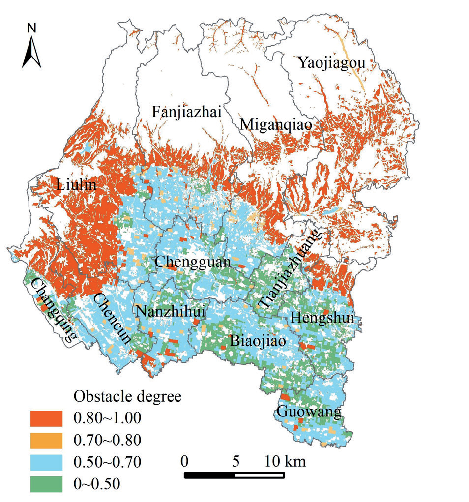
Using the constructed obstacle diagnosis model, we examined the obstacle degree of each dimension of well-facilitated farmland construction in Fengxiang District, Baoji City, as shown in Fig. 3. Based on relevant research foundations, limiting factors that reach a moderate level will have an impact on the construction of well-facilitated farmland. Therefore, the critical value of obstacle degree Q is determined as 0.5, and combined with the natural breakpoint method in ArcGIS, the obstacle degree of each dimension was divided into 4 levels. The obstacle index for level 4 obstacles ranges from 0 to 0.50, the obstacle index for level 3 obstacles ranges from 0.50 to 0.70, the obstacle index for level 2 obstacles ranges from 0.70 to 0.80, and the obstacle index for level 1 obstacles ranges from 0.80 to 1. After calculation, the area of the level 4 obstacle was 93.42 km2, accounting for approximately 16.41%, and was mainly distributed in the southeast of Fengxiang District. The area of level 3 was 239.12 km2, accounting for approximately 42.01%, mainly distributed in the southern plain area of Fengxiang District, with the main obstacle factor being irrigation water sources. The area of level 2 is 20.79 km2, accounting for approximately 3.65%; these areas were mainly scattered and the main obstacle factor is the size of the field. The area of level 1 is 215.86 km2, accounting for approximately 37.92%, mainly distributed in the eastern, western, and central mountainous areas of Fengxiang District, and the main obstacle factors are field scale, irrigation water source, irrigation guarantee rate, and slope gradient.
Zoning Results of Well-Facilitated Farmland Construction
Fig. 4 shows the zoning results for well-facilitated farmland construction in Fengxiang District. The priority construction area has high suitability for land construction and does not have ecological constraints that are difficult to transform. With slight improvement, it could be classified as well-facilitated farmland. This type of farmland covers an area of approximately 270.28 km2, accounting for 47.49% of the area, mainly concentrated in the southern plain area. The terrain of this area is flat, and the plots are relatively regular, with good connectivity of cultivated land, suitable for mechanized planting, unified management, and maintenance. Additionally, the area has sufficient water sources and complete infrastructure, making it a priority and key construction area for well-facilitated farmland.
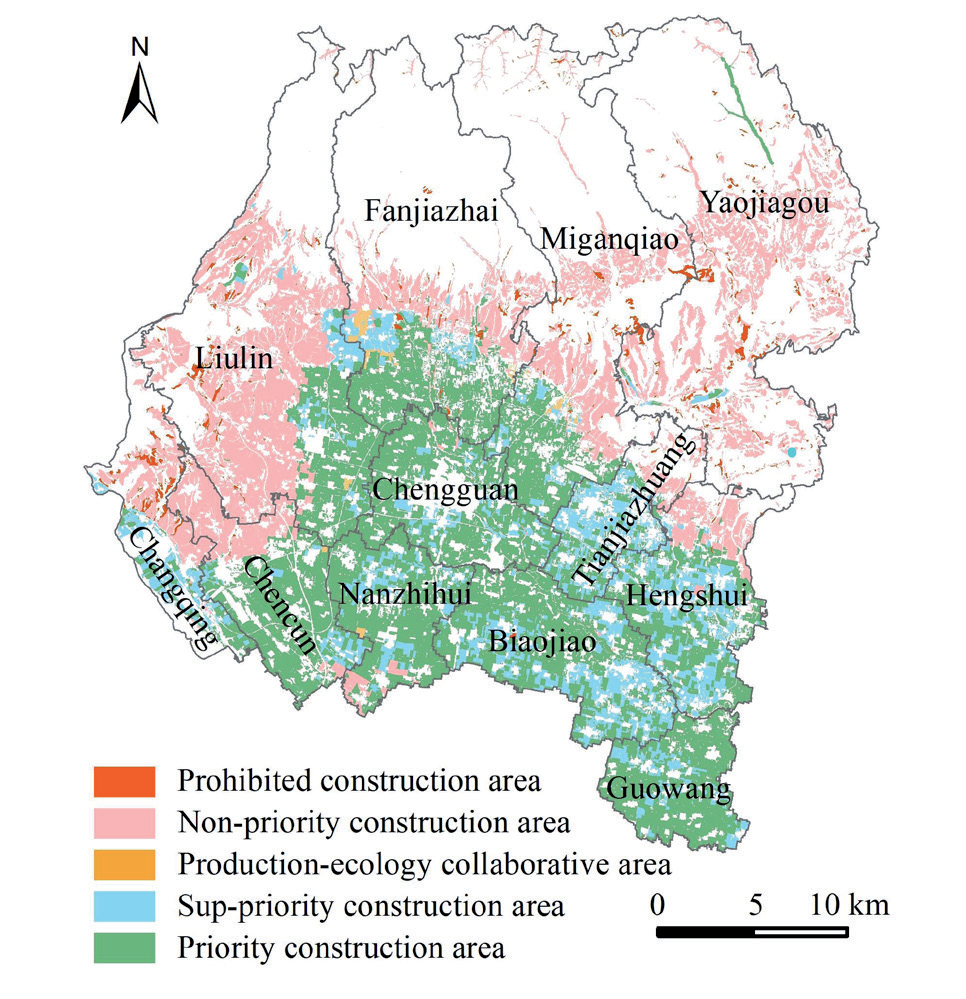
The sub-priority construction area has relatively high construction suitability, but there are level 1 obstacle factors or difficult-to-transform factors outside of the ecological dimension. Therefore, certain rectification measures must be taken in these regions to be classified as well-facilitated farmland construction areas. This type of cultivated land covers an area of approximately 87.39 km2, accounting for 15.35% of the total area, which is mainly concentrated in the southeastern plain area. The cultivated land in this area has good site conditions, flat terrain, and regular land plots. However, the irrigation water source and irrigation guarantee rate are slightly low, requiring further improvement and construction.
The production-ecology collaborative construction area has moderate construction suitability, with only one type of high obstacle or difficult transformation factor, which belongs to the dimension of ecological constraints. This type of cultivated land covers an area of approximately 3.28 km2, accounting for 0.58% of the total area. These areas are mainly scattered and require further improvement and construction in terms of effective soil layer thickness, irrigation guarantee rate, and irrigation water source.
The construction suitability of the non-priority construction area is relatively low, and there is only one type of high obstacle or difficult-to-transform factor, but this factor does not belong to the dimension of ecological constraints. The reserve construction area has a large area of cultivated land, approximately 196.02 km2, accounting for 34.44% of the total area. It is mainly distributed in the central, eastern, and western mountainous areas. The cultivated land resource endowment in this area is poor, and the cultivation conditions are relatively difficult. However, construction costs are relatively low, and this area should be used as a reserve for well-facilitated farmland construction.
In the prohibited construction areas, there are at least two factors: poor suitability for construction, high obstacle rates, and difficulty in transformation. The cultivated land in this region covers approximately 0.31 km2, accounting for 0.05% of the total area. These areas are mainly scattered in the eastern and western mountainous regions and are no longer suitable for crop cultivation. Therefore, more effective and orderly exit mechanisms should be explored for this part of the cultivated land or used as backup resources for regulation.
Conclusions
The new suitability evaluation system for county-level well-facilitated farmland construction in Fengxiang District, Baoji City, based on four factors (soil conditions, infrastructure constructions, landscape patterns, and ecological constraints), provides a comprehensive assessment of construction suitability. Overall, the suitability of well-facilitated farmland construction in the district is good. The sub-priority construction area covers the largest area of approximately 271.99 km2, accounting for 47.79% of the total farmland area, whereas the priority construction area covers approximately 84.46 km2, accounting for 14.84% of the total cultivated land area.
The obstacle factor diagnostic model effectively reflects the impact of various land parcel factors on well-facilitated farmland construction, allowing for the accurate identification and assessment of obstacle factors. The landscape patterns and ecological constraints have relatively high obstacle degrees in Fengxiang District, with the main obstacles in the landscape pattern dimension being related to field scale and in the ecological constraints dimension being irrigation water sources and slope gradient.
Based on the order of suitability and transformation difficulty, and considering ecological constraints, Fengxiang District is divided into five categories: priority construction area, sub-priority construction area, production-ecology collaborative construction area, non-priority construction area, and prohibited construction areas. The cultivated land in the priority construction area accounts for 47.49% and is highly suitable for construction, requiring only slight renovation. The sub-priority construction area accounts for 15.35% and needs further improvement in irrigation water sources and guarantee rate. The production-ecology collaborative construction area covers 0.58% of the cultivated land. The non-priority construction area accounts for 34.44% and is mainly located in the central, eastern, and western mountainous regions. The prohibited construction areas cover 0.05% (0.31 km2) of the total area and should be subject to orderly exit mechanisms.
The research method and results presented in this paper are directly applicable to the site selection and planning of specific well-facilitated farmland construction projects, considering the practicality of engineering construction. More importantly, the ecological niche model used in this study does not neglect the concept of well-facilitated farmland for ensuring food production capacity and disaster resistance ability. Instead, it emphasizes a holistic approach that, while maintaining production capacity, also promotes green and high-quality development. This new well-facilitated farmland construction method improves the scientificity of well-facilitated farmland planning and construction, thus maximizing the benefits of investing in the construction project.
It should be pointed out that because the 15 evaluation factors selected in this paper still cannot fully represent the actual situation of farmland, and there may be conflicts in the actual construction process. Therefore, when choosing the construction site of convenience well, we should consider the actual situation of the area and conduct comprehensive research and judgment.

