

Introduction
The rate of urbanization in developing countries is accelerating, and urban-rural conflicts are becoming increasingly prominent. A large amount of agricultural land in marginal urban areas has been occupied [1, 2], with chaotic management and an uneven distribution of funds [2-4]. The unequal distribution of natural resources in urban and rural development, especially water resources, has had a negative impact on rural agricultural development [5]. The layout of major infrastructure in urban and rural areas affects rural use of surface water and reduces the area of agricultural land [6]. In short, in the process of urbanization, the ability of villages to access resource allocation is weaker than that of cities, limiting and hindering rural development.
Rural planning is the overall plan for the long-term development of society, economy, science, and technology and is the fundamental basis for guiding rural development and construction [7, 8]. In the past 22 years, China has completed the preparation of planning for all villages, which has played an irreplaceable role in building a moderately prosperous society in all aspects of the countryside. Global research on rural planning has not stopped. For example, rural land use planning [9-12], rural public service facilities planning [13-15], rural cultural facilities planning [16-18], rural spatial planning [19-22], rural spatial evolution [23, 24], rural tourism planning [25-27], rural industrial planning [25, 28, 29], and so on. Although rural planning is a universal phenomenon worldwide, research results are abundant. However, for a country with 5.3 million square kilometers of rural area, it is rare worldwide to have completed the preparation of all rural planning and implemented them one by one in more than 20 years. Therefore, it is of great significance to analyze the research progress and frontier of rural planning in China, whether for scholars engaged in rural planning in China or around the world.
This study aims to objectively identify the topics and frontiers of rural planning research. In addition, the study identifies research hotspots and stages of development through temporal changes in research activities. Finally, the authors’ research institutions and collaborations are also analyzed.
The classical literature review is a manual method of filtering and analyzing a large amount of literature to obtain research conclusions. This method is not only laborious but also prone to gaps and omissions. In addition, more efforts are required to collect comprehensive information and nuances from the massive volume of papers and academic literature. To achieve a complete and objective presentation of the research results on rural planning in China, we used bibliometric methods and analyzed the research using a computer technology approach. Bibliometric analysis is a popular scientific and technological text-mining tool that can quantitatively analyze the existing literature in a specific field [30]. It helps to access indicators and methods widely, identify distributed architecture features and patterns of basic science and technology, and assess trends and future studies [31]. Currently, the scientific knowledge graph, or knowledge graph, as a new method and new field of scientometrics, is booming worldwide and has achieved considerable progress [32].
The study is structured as follows: Section 1 is the introduction. In Section 2, the study design is described. Section 3 contains the results of this study. In addition, Section 4 discusses the findings developed in Section 3 and summarizes some characteristics of the Chinese rural planning study. In addition, Section 5 concludes.
Materials and Methods
Data Source and Retrieval Strategy
Data source: The Chinese Social Science Citation Index CSSCI database, which was established by the China Social Science Research Evaluation Center of Nanjing University, is a landmark database in the field of Chinese humanities and social science evaluation. It contains more than 500 humanities and social sciences journals that have shown the highest level of scientific research in China since 1998, as well as the most cutting-edge achievements.
Search strategy: To make the data comprehensive and complete, we set the search terms as “village” + “planning” and “settlement” + “planning.” The search conditions were set as: “all fields” with a period of “1998–2020”; based on the above search terms, first and second searches were performed. The search results were checked and sorted, and irrelevant data samples were eliminated, thus generating an effective result of 643 sample documents.
Research Methods
This study used the computer software CiteSpace to conduct a comprehensive and systematic bibliometric analysis of Chinese rural planning research over the past 22 years. CiteSpace is a scientific bibliometric automation software developed by Professor Chen Chaomei from the School of Information Science and Technology at Drexel University in the United States. It is easy to capture a detailed matrix of the relationship between different objects and visualize it intuitively to enhance people’s cognition of this abstract information [33]. CiteSpace provides 11 options for the cooperation map of citing documents (author, national, and institutional cooperation), co-occurrence maps (feature words, keywords, and subject categories), and co-citation maps for cited documents (document co-citation, author co-citation, and journal co-citation) [32]. At present, many scholars are using this software to analyze a lot of fields around the world, such as the analysis of information science, environmental sciences, computer science, and the public environment. In particular, Chaomei Chen successfully predicted the winners of the 2012 Nobel Prize in Physiology through this software in the paper “Emerging trends in regenerative medicine: a scientometric analysis in CiteSpace” [34]. The superiority of this software is enough to reflect.
Results
Literature Quantity Analysis
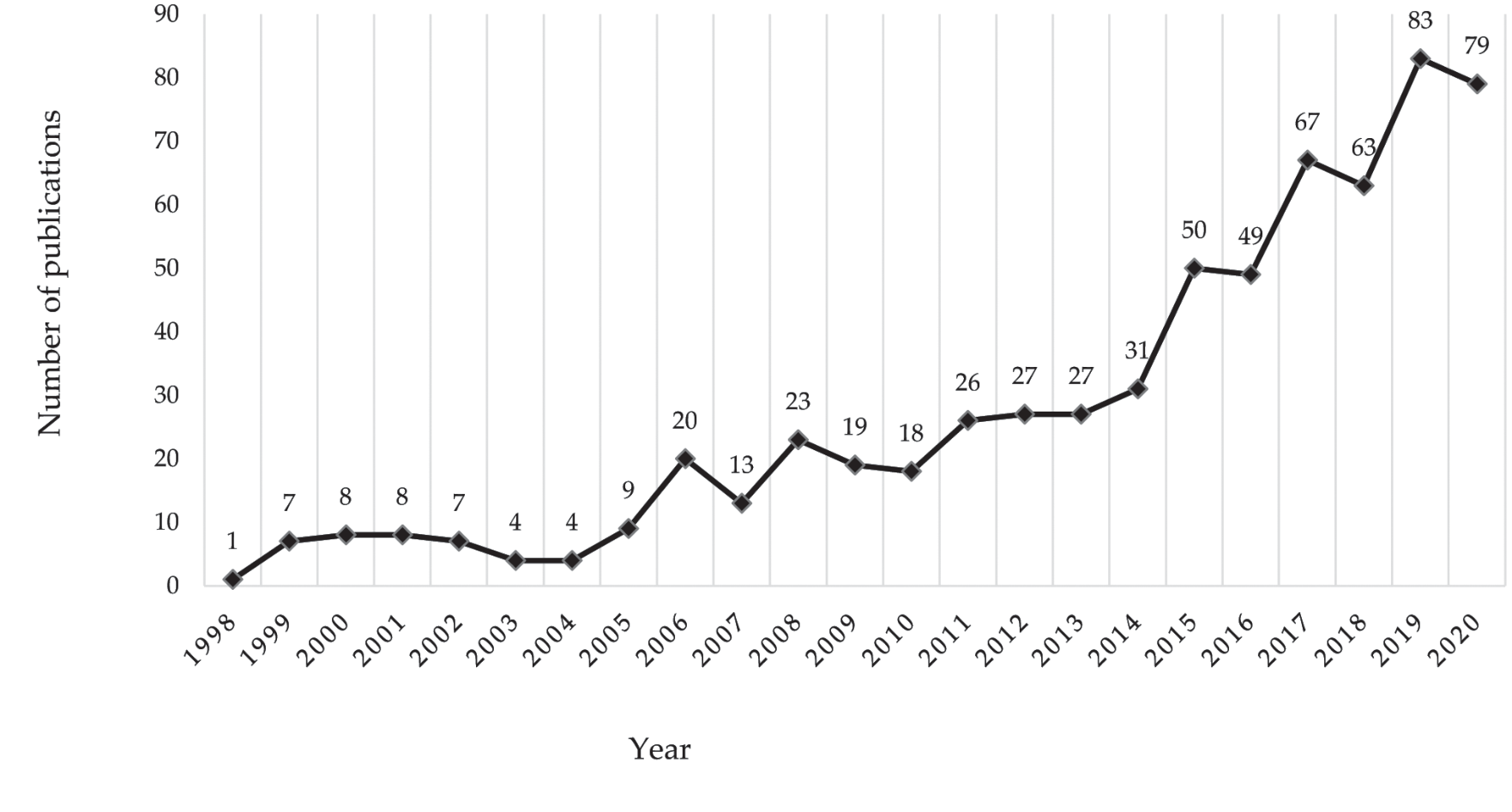
The annual number of publications of research literature can reflect the degree of activity and attention in this research field [35]. Fig. 1 shows the publication of research papers on rural planning in China from 1998 to 2020. As can be seen from the figure, in the past 22 years, Chinese scholars have published 643 papers on rural planning research. The average annual number of published papers was 29.23, and the average annual growth rate was 21.97%. The number of papers published in 2019 was the largest, accounting for 83—12.91% of the total number of published papers. In 2003 and 2004, the smallest number of papers were published, only four (0.62%); from 1998 to 2006, the number of papers published per year increased from 1 to 20, and the average annual number was 7.56, with an average annual growth rate of 39.50%. From 2007 to 2017, the number of papers published per year increased from 20 to 67, averaging 31.82 papers published, with an average annual growth rate of 16.08%. From 2018 to 2020, the number of published papers increased from 67 to 79, with an average annual publication of 75 papers and an average annual growth rate of 7.84%. The average annual number of published papers has been increasing, while the average annual growth rate has been gradually decreasing, indicating that research on rural planning has received continuous attention from relevant scholars during the studied period.
Research Topics of Rural Planning in China
Keywords, as important terms that can reflect the core content and research focus of the article, allow a high degree of generalization and refinement of the subject of the article [35]. The paper adopts the method of keyword clustering, which is labeled by the LRI algorithm, to explore research topics regarding rural planning in China. A total of 14 clusters are formed, as shown in Fig. 2. The module value Q (Modularity) and the average contour value S (Mean Silhouette) were used as important indicators to measure the clarity and scale of clustering. It is generally believed that the Q-value is generally in the [0, 1) interval, and Q > 0.3 means that the divided community structure is significant. When the S-value is 0.7, the clustering is highly efficient and convincing. If the Q-value is above 0.5, clustering is generally considered reasonable [32]. The results show that the module value Q = 0.8982, the average profile value S = 0.9561, and the results are robust, indicating that the boundaries between the research topics of rural planning are clear and the field differentiation is obvious.
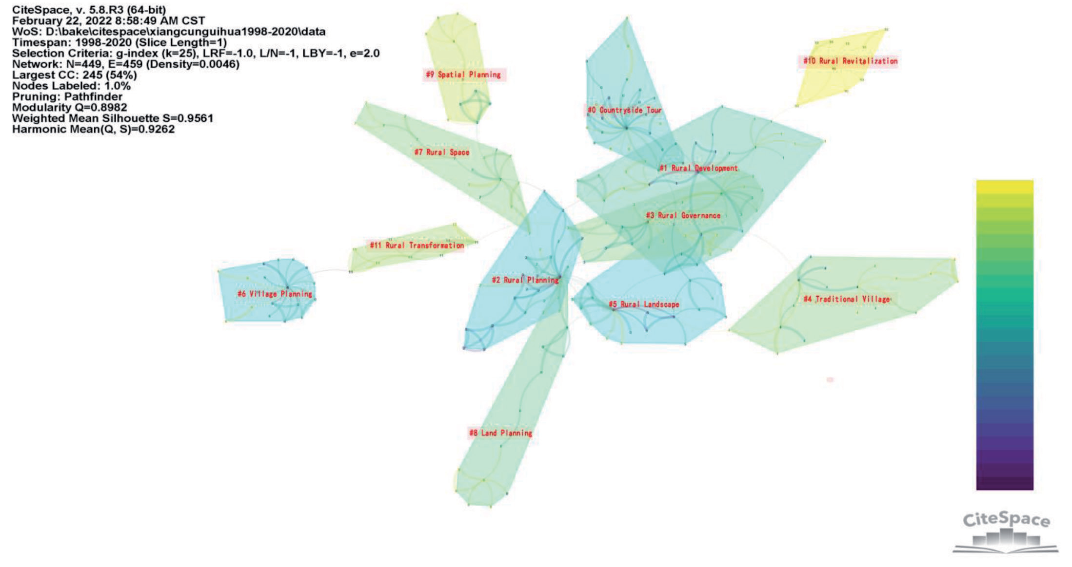
According to the research content and clustering situation, cluster numbers #0, #1, #4, #10, and #11 belong to the theme of rural transformation and development. Cluster numbers #3, #7, and #9 belong to the theme of rural spatial characterization and optimization. Cluster numbers #2, #5, #6, and #8 belong to the subject of rural planning techniques and methods.
Research Hotspots and Evolution of Rural Planning in China
Hotspots are scientific issues or topics that have attracted widespread attention and discussion by scholars or experts over a certain period of time [35]. Keywords reflect a high-frequency period and the attention of scholars and experts discussing related issues. The paper uses keyword co-occurrence to detect high-frequency keywords and the co-occurrence relationships between them to explore research hotspots and the evolution of rural planning in China. Table 1 provides the highest frequency of 20 keyword statistics, ranked in descending columns.
It can be seen from Table 5 that the high-frequency keywords are mainly concentrated in “Rural Revitalization” (57 times), “Rural Planning” (43 times), “Rural Tourism” (38 times), “Village Planning” (31 times), “Traditional Village” (31 times), “Rural Governance” (21 times), “urbanization” (17 times), etc. These high-frequency keywords show the current research hotspots in rural planning.
Table 1.
Top 20 keywords’ co-occurrence frequency.
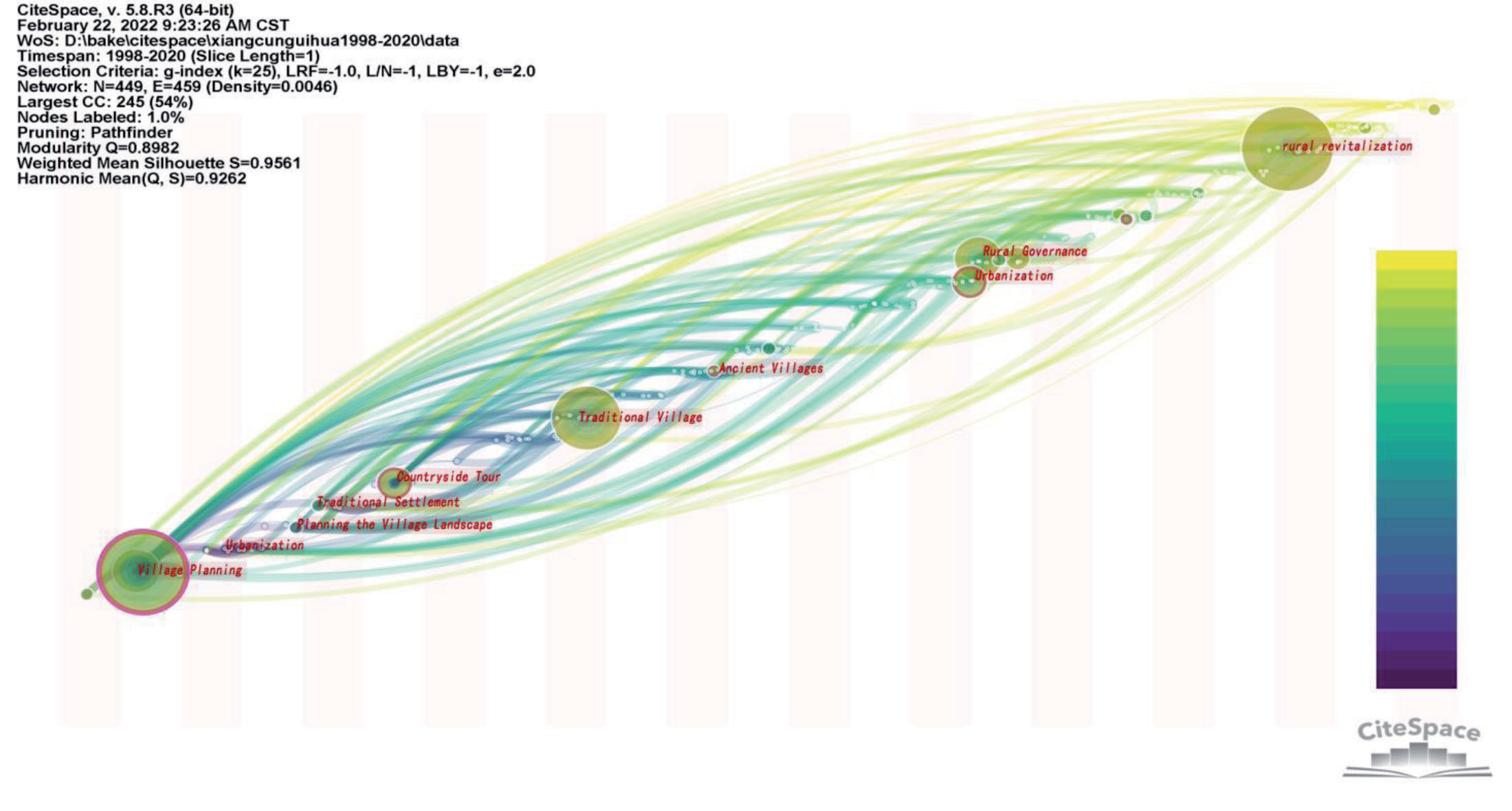
Table 2.
Top 20 keywords’ co-occurrence frequency.
In order to discover the evolutionary laws of research hotspots of rural planning in China, the paper adds time elements to keywords and forms a time zone map of these words. The Node Type was set to keywords, the program was run, and a time zone map of hot words was generated, as shown in Fig. 3. The results show that there are 449 nodes, 459 connections, and a network density of 0.0046. Each node represents a keyword, the size of the node represents the frequency, the colorful columns represent the year, the connection between the nodes represents the co-occurrence network of the keyword, and the horizontal axis time represents the year when the hot word appeared.
It shows from the time zone map of hot words that the three-time points for the appearance of high-frequency hot words were 2005, 2013, and 2018, after deducting the publication period of hot literature (tentatively one year). That is, the time when the hotspot of rural planning research appeared was 2004, 2012, and 2017.
According to the time node when the hot words appeared, the evolution of the research hotspots of rural planning in China is divided into three stages. The first stage was the preliminary rejuvenation period (1998–2004), and the main hot words were “village development” and “village planning.” The second stage was the rapid development period (2005–2012), and the main hot words were “village planning,” “rural tourism,” “new rural construction,” “village,” “planning,” “village construction,” “Southern Jiangsu,” “urbanization,” “rural geography,” and “urban and rural coordination.” The third stage was a period of steady growth (2013–2020), and the main hot words were “traditional villages,” “township,” village governance,” “village transformation,” “ancient villages,” “beautiful villages,” “village revitalization,” and “village revitalization.”
Research Frontiers of Rural Planning in China
Research frontiers refer to a group of emergent “dynamic concepts and potential research problems” and emphasize the characteristics of new trends and bursts, which can be characterized by the rate of change in the frequency of literature citations or the number of occurrences of keywords [32]. Therefore, the detection of emergence is considered to be an indication of highly active areas of research that can explore emerging and fleeting trends [36].
In order to study the research frontiers of rural planning in China, the thesis utilizes Burst Detection to extract words with a high word frequency change rate. Articles for keyword emergent testing identified seven emergent vocabularies, namely, “rural revitalization,” “rural planning,” “new rural construction,” “rural tourism,” “urbanization,” “urban and rural coordination,” and “planning,” arranged in ascending order of appearance as shown in Table 2.
Research Collaborative Models of Rural Planning in China
A cooperation map can discover the social relationships between scholars, countries, or research institutions in a certain research field and can provide a new perspective for evaluating the academic influence of scientific researchers, countries, or institutions, as well as help to discover those significant researchers, institutions, and countries [32]. The following section analyzes the cooperation between institutions and authors in the study of rural planning in China.
Analysis of Institutional Cooperation
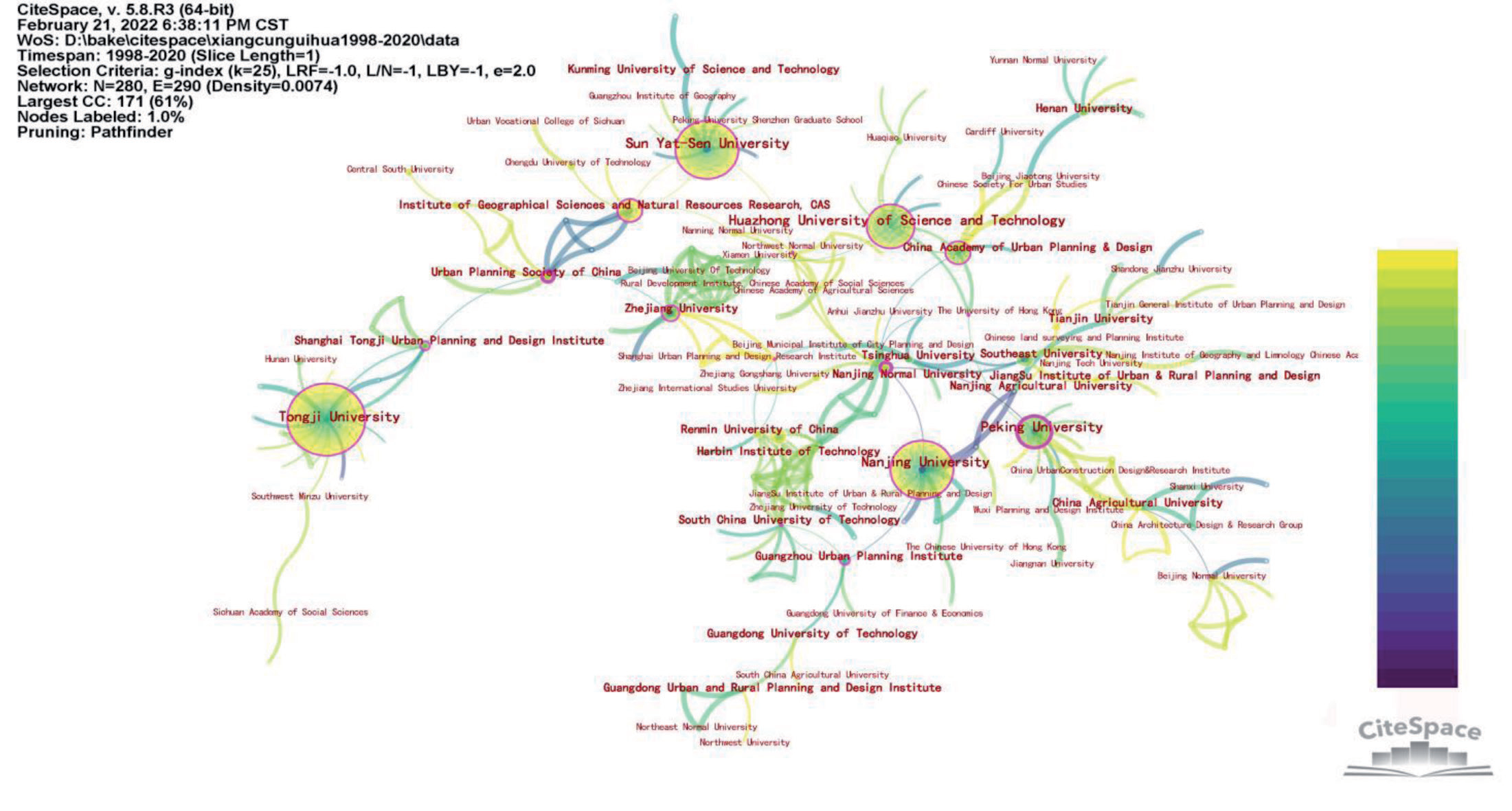
The network pruning method was set to pathfinder and the Node Type to Institution, and then the program was run to generate a knowledge network graph of institutional cooperation, as shown in Fig. 4.
As shown in Fig. 4, there are 280 nodes and 292 connections, and the network density is 0.0075. Each node represents a research institution, the size represents the frequency of the institution’s posting, and the connection represents the cooperative relationship between institutions. Overall, 280 institutions had published papers on China’s rural planning research, of which 152 were universities, accounting for 54.29%, and there were 290 cooperative groups among them. Table 3 shows that universities account for a relatively high proportion of China’s rural planning research institutions, and most of the cooperation between these research institutions revolves around universities.
Analysis of Author Collaboration
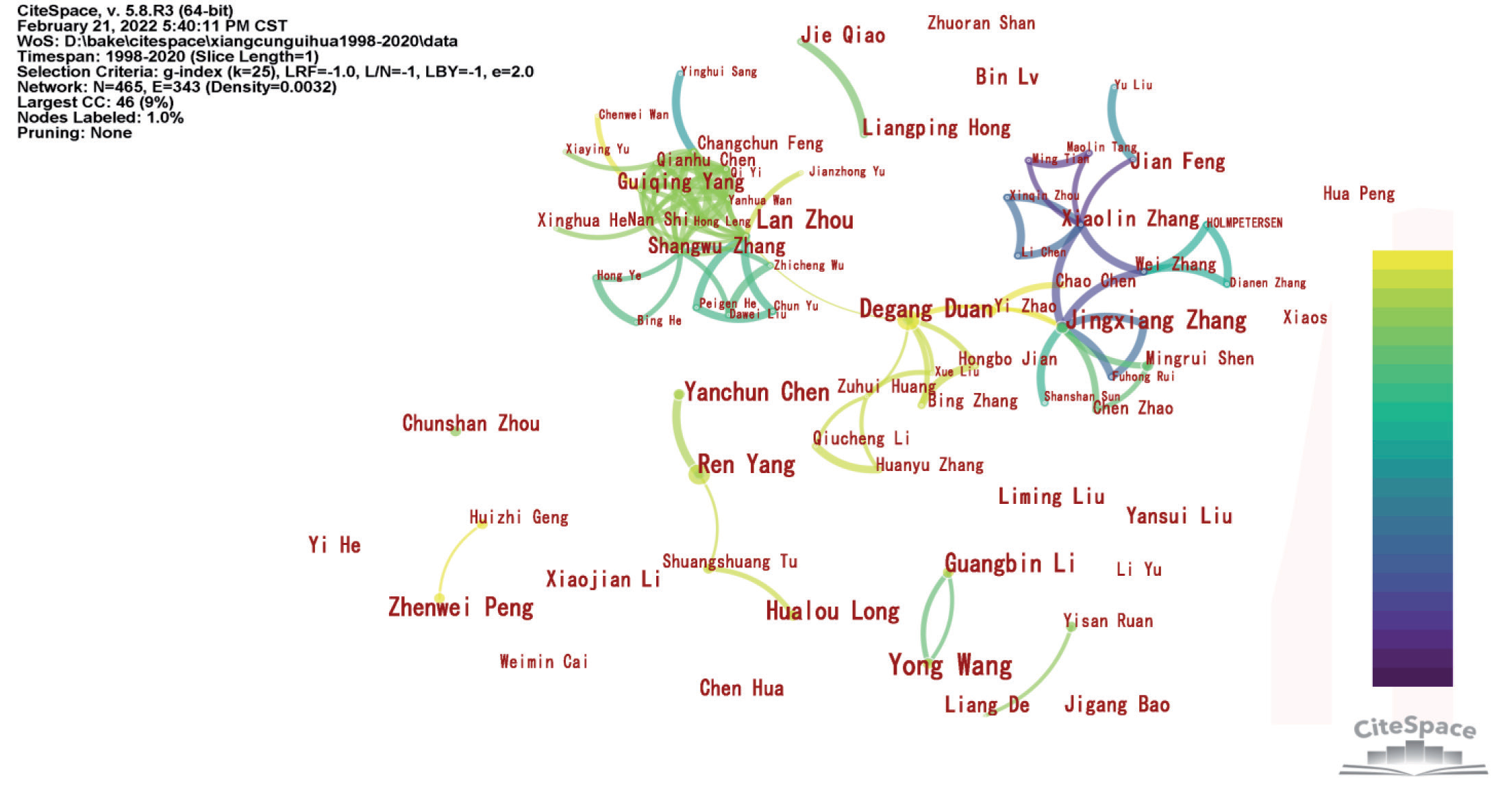
As shown in Fig. 5, there are 465 nodes, 343 connections, and a network density of 0.0133. Each node in the figure represents an author, the size represents the frequency of the authors’ publications of papers, the connection represents the cooperative relationship between the authors, and the thickness represents a close degree of cooperation.
The results show that 465 authors had published papers on the study of rural planning in China, of which 343 groups of authors had a cooperative relationship. From Table 4, it can be seen that there were 27 authors with more than four papers. There are about ten authors forming ten collaborative teams. Among them, the teamwork network of Zhou Lan [37], Duan Degang [38-40], Zhang Jingxiang [41-43], and Zhang Xiaolin cooperated in a more complex network, followed by Yang Ren’s [44-46] team, while the rest of the five teams, including Li Guangbin [47-53], and Ruan Yisan [54-59], had a simple approach to collaboration.
Research Disciplinary Foundations of Rural Planning in China
Journal Co-Citation Analysis
Journal co-citation can be used for basic research in the field of discipline [32]. The center of the journal may indicate that it functions as a bridge between the subject areas. As shown in Fig. 6, there are 635 nodes, 2063 connections, and a network density of 0.0103. Each node in the map represents a journal, the size represents the frequency of citations, the purple circle outside the node represents the centrality of the node, and the thickness of the purple ring represents the strength of the centrality.
Table 3.
Institutions with more than 20 papers published in 1998–2020.
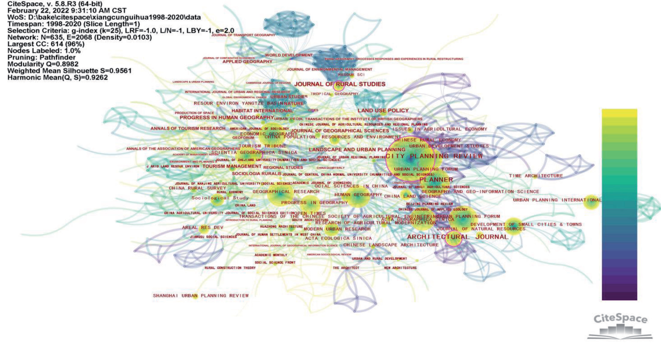
The results show that 635 journals had been cited, and there were 2068 groups of co-citation relationships. The journals with a frequency of more than 30 citations were counted, as shown in Table 5. It showed that there are three categories of cited journals: namely, urban and rural planning, geography, and other rural-related disciplines. In geography, rural geography takes the vast rural areas outside the city as the research object and is committed to studying the human geography of rural areas. The main focus is on the socioeconomic regional system and its environmental relationship in rural areas, as well as the science of predicting its development, while rural planning, with the characteristics of “social planning,” faces social and renewal issues caused by rural shrinking [60]. Therefore, there are many important and highly cited journals in geography. It shows that geography and sociology were the disciplinary foundations of rural planning research.
Table 4.
Authors with more than four papers published in 1998–2020.
Table 5.
Journals with more than 30 citations.
Literature Co-Citation Analysis
In the evolutionary relationship of a document co-citation network, there are usually nodal documents that play a turning point in the field of research. We call such documents Key Node documents [61]. Betweenness centrality is a concept developed primarily by the American sociologist Professor Linton C. Freeman and is a measure of the extent to which a point lies “in the middle” of other “pairs” of points in a diagram [62]. Different document clusters are linked by key node documents. Usually, these document nodes have high betweenness centrality and play the role of a bridge for connection and transition among different clustering networks [61]. The betweenness centrality is greater than or equal to 0.1, which is the key node. Herein, we counted the documents of these key nodes and arranged them in descending order of centrality, as shown in Table 6.
Table 6 shows there were a total of 25 key node literature works. There were 17 nationally important journals in the direction of geographic sciences, six in the direction of urban and rural planning, and two in the direction of social sciences. It shows that geographic sciences and social sciences, which play a key transitional role in rural planning research, are the important bridge for rural planning research in China and the disciplinary foundation of rural planning research.
Table 6.
Co-cited documents with a centrality greater than 0.1.
Discussion
Advantages of Bibliometrics
The innovations of this paper lie in the use of scientific metrology and visual analysis techniques to analyze the evolution and picture of rural planning research in China, followed by systematically sorting out research topics, research hotspots evolution and research frontiers, models of cooperation, and disciplinary foundations over the past 20 years. Compared to traditional literature review methods, bibliometrics has the following advantages: It can comprehensively grasp the research status (number of authors, institutions, and articles) in the past decades through co-occurrence analysis; determine the disciplinary foundations of research objects through co-citation analysis; find articles and journals that are in the bridge of knowledge network by calculating centrality; understand research topics through keyword clustering analysis; understand the evolution pattern of research hotspots through high-frequency keywords and the co-occurrence between them; and discover the frontier of knowledge through keyword burst analysis.
Research Topics
The results of the keyword cluster analysis and Chinese rural planning research mainly focus on three topics: rural transformation and development, rural spatial characterization and optimization, and rural planning techniques and methods.
Rural transformation and development topics: Research on rural transformation focuses on the transformation and reconstruction of the Chinese countryside [63, 64], the understanding of the countryside [65], and the transformation of the world’s countryside [66]; research on the development of China’s countryside focuses on multifunctionality [67], farmer tourism [68], the protection of traditional villages [69], and countryside lodging [45].
Rural spatial characterization and optimization topics: Relevant researchers have studied the characteristics of rural space in Jiangsu Province [70], Southern Jiangsu [71, 72], Longzhong loess hilly area [73] and Guangdong Province [74]; rural spatial reconstruction [75], spatial transformation [76], and spatial optimization [77] are also research themes of rural space.
Rural planning techniques and methods topics: Many studies on these topics have examined rural planning techniques and methods from different perspectives. For example, the geographical perspective [78, 79], the economic cycle perspective [80, 81], and the governance system perspective [82] are common entry points for research.
Evolution of Research Hotspots
From the results of keyword co-occurrence and emergence analysis, the stage of hotspot evolution of rural planning research in China is close to the level of urbanization. In the early 1990s in China, the urbanization rate was low. At this stage, urban development was the main focus, and the rural areas were in a period of slow development. After 2004, China’s urbanization rate exceeded 40%. The imbalance between urban and rural development increased. In order to balance the urban-rural conflict, rural development has been accelerated into a period of rapid development. During this period, the legal status of rural planning was established, new rural construction was carried out, and the rural living environment was greatly upgraded. By 2012, China’s urbanization rate had risen again, exceeding 50 percent, and the upgrading of the rural living environment had been basically completed. Rural development had entered a stage of stable development, with the protection of traditional villages and the revitalization of rural industries proceeding steadily.
Research Frontiers
The emergence of the word “urbanization” started in 2000 and ended in 2007, with an intensity of 4.00. Since the reform and opening up, especially since the 1990s, urbanization has been advancing rapidly in China [83], which has had an impact on the rural settlement space [84], leading to a strong demand for the transformation of peri-urban villages [83] to meet the demand for urban tourism [85]. “Urbanization” is the main reason for the emergence of the term in the latter years.
(2) Emerging Words Appearing at the Same Time: “New Countryside Construction,” “Rural Tourism,” “Urban and Rural Planning,” “Village Planning,” and “Planning”
Urbanization has driven the upgrading of rural environments, reconfigured urban-rural relations and industries, and strengthened planning. It is mainly reflected in the following five emergent words:
New Environment—the emergent word “new countryside construction” began in 2006 and ended in 2011, with a strength value of 7.48. This term refers to the new requirements of the “Eleventh Five-Year Plan Outline and Proposals” adopted by the Fifth Plenary Session of the Sixteenth Central Committee of the Communist Party of China on 8, October 2005, for China’s rural development. Subsequently, studies on residential surveys [86], public participation [87], and rural planning methods [88] for new rural construction have emerged in the research on rural planning in China.
New Industry—the emergent term “rural tourism” began in 2005 and ended in 2011, with an intensity of 6.20. With the increase in urbanization, the demand for urban tourism increases, and villages have taken advantage of the natural environment and have actively developed the tertiary industry. Therefore, there have been studies related to the new model of rural tourism [89], the spatial regional characteristics of rural tourism [90], and the standardization of rural tourism [91].
New Relations—the emergent term “urban and rural coordination” started in 2006 and ended in 2013, with an intensity of 3.75. In terms of urban–rural relations, developing from urban-rural dual structure to urban-rural integration, the system reconstruction [92], layout reconstruction [93], and habitat reconstruction [94] of the countryside have become the focus of research.
New Planning—the emergent word “rural planning” started in 2004 and ended in 2012, with an intensity of 8.42. After the Fifth Plenary Session of the Sixteenth Central Committee of the Communist Party of China proposed the construction of a new countryside, the study of Chinese rural planning gradually increased, providing a planning basis for the construction of a new countryside. The emergent word “planning” started in 2009 and ended in 2011, with an intensity of 3.59. In 2008, China promulgated the “Law of the People’s Republic of China on Urban and Rural Planning” to replace the “Law of the People’s Republic of China on Urban Planning,” incorporating village planning into China’s urban and rural planning law system. There is also a further increase in the types [95] and systems [96] of research on village planning.
The emergent word “rural revitalization” started in 2018 and ended in 2020 (the data collection period was 2020), with an intensity of 14.28. General Secretary Xi Jinping put the rural revitalization strategy forward in the report of the 19th National Congress of the Communist Party of China. It is a strategy to be implemented in order to solve the “three rural” issues of agricultural and rural farmers. As a result, studies on network pathways for rural revitalization [97], key technologies for rural revitalization [98], and village planning for county town systems for rural revitalization [99] emerged.
Models of Cooperation
The results of the cooperative network analysis show that the cooperative relationship between rural planning preparation enterprises in China is weak. The number of rural planning preparation enterprises accounts for 45.71% of the total number of organizations in China’s rural planning research and publication institutions, which is a high proportion. However, these enterprises do not form cooperative teams with each other, but all of them work as members of university teams. None of the enterprise authors are also core authors in any of the five main author cooperative teams.
Disciplinary Foundations
The results of the analysis of journal co-citations show that the disciplinary foundations of rural planning research are geography and sociology. Rural geography is a discipline that studies the formation, functional structure, development, and evolution of villages, as well as their spatial system distribution patterns. It explores a range of economic, social, demographic, settlement, cultural, and resource utilization issues in villages in different regions. Sociology is a social science that systematically studies social behavior and human groups. As the rural area is a social form of human agglomeration, geography and sociology naturally become the disciplinary basis of rural planning research.
Value of Practical and Academic Research
This paper’s objective judgment of rural planning research in China can help rural planners approach rural planning research topics and evolution in a rational way. It is because of this study that the field can be better understood. The study identifies rural planning research topics, hotspots, stages of development, and frontiers, which means that learners of rural planning at different stages will receive different perspectives and sources of knowledge. The frontiers in rural planning are varied at each stage, and education should then adapt its content to suit the needs of the rural village. Rural planners should be retrained to meet the new requirements of rural planning development. It has significant implications for both rural planning practice and planning education theory.
Limitations of This Study
There are still many unanswerable questions about the trends observed in rural planning. Firstly, further research is needed to specifically investigate the dynamics of each cluster and the reasons for their interconnections and transformations; secondly, appropriate policy documents should be added to the data. A textbook analysis of the document data is conducted to discover the relevance of the research to policy; finally, a modest increase in research occurs at the intersection of disciplines. The follow-up study adds data from non-rural planning disciplines to discover trends in the intersection of rural planning with other disciplines. These limitations are also the directions that need to be further improved upon in follow-up research.
Conclusions
Over the past two decades, developing countries have experienced rapid urbanization. It has been accompanied by unusually sharp urban-rural conflicts, which have posed major challenges to social stability. China, as the largest developing country, has completed the task of preparing rural planning for 5.3 million square kilometers and implementing rural planning, which is rare in the world. Therefore, our review of China’s rural planning research during this period is of great value and significance to rural planning and related research worldwide.
This paper used the bibliometric analysis software CiteSpace, based on CSSCI data, and visually analyzed the progress and frontiers of China’s rural planning research. The research found that: Firstly, the number of rural planning research literature has been increasing year by year, since 2006, and it reached a peak in 2019; the proportion of colleges and universities in research institutions is high, and a cooperation network has been formed with colleges and universities as the core; the cooperation between research scholars is weak, and a total of 10 cooperation networks have been formed, among which the team cooperation network of Zhou Lan, Duan Degang, Zhang Jingxiang, and Zhang Xiaolin is more complicated, followed by Yang Ren’s team, and the other five teams are composed of two authors, where the cooperation is relatively simple. Secondly, geography and sociology are the disciplines of basic Chinese rural planning research. Finally, the research on rural planning in China mainly focuses on three aspects: rural transformation and development, rural spatial characterization and optimization, and rural planning techniques and methods. Research hotspots have experienced three stages: the initial revival period, the rapid growth period, and the steady development period. The frontiers of the research are: “rural revitalization,” “village planning,” “new rural construction,” “rural tourism,” “city,” “urban and rural,” and “planning.”

