

Introduction
Phytosociology deals with the classification of vegetation based on the co-occurrence of species and their interactions with the environment. Vegetation is a component that is so distinctive in its physiognomy and structure that it can be distinguished from other such components [1]. Given the diverse environmental factors at play, the composition and species of plants fluctuate across geographical zones worldwide. Vegetation is a unit that possesses traits in physiognomy and structure sufficiently large enough to facilitate its distinction from other similar units [2]. Examination of vegetation sheds light on how plant communities interact with the climate and soil characteristics within a particular region [3]. The composition, structural dynamics, and function of forest ecosystems are influenced by topographic, climatic, edaphic, and anthropogenic variables [4-7]. Mountain ecosystems provide a wide variety of products and resources to humans, both those who live in the mountains and those who do not. For example, more than half of the world’s population relies on freshwater gathered, conserved, and filtered in hilly places. Mountainous places are hotspots of biodiversity. Furthermore, mountains are important tourist and recreational destinations around the world. Mountains are essential resources for rapid world development [8]. Globally, every third plant species is native to mountain regions [9]. Forest ecosystems cover almost 5.01% of Pakistan’s land area, which is far below the international per capita standard. Khyber Pakhtunkhwa, the northern province of Pakistan, is home to nearly 40% of the country’s natural forests, covering almost 17% of the total land area of the province [10]. Malakand has the largest number of natural forests in Khyber Pakhtunkhwa. Several studies around Dir Upper, Pakistan, contributed to our understanding of forest types ranging from subtropical to high altitude. Deforestation, logging, clearing for terrace cultivation, and overgrazing are the major challenges for these forests [7]. Important ecological characteristics that are significantly related to anthropogenic and environmental factors include vegetation structure, species composition, and diversity [11]. The distribution of plant communities is influenced not only by environmental variables, but also by geographical and human factors, as well as species competition [12]. Advances in phytosociological techniques include the use of different advanced software packages, such as JUICE [13] and R Package [14]. Cluster analysis [15] and ordination [16] are the most commonly used techniques for the classification and ordination of vegetation communities. Cluster analysis approaches are applied to analyze ecological groups and group them into associations [17], while ordinations provide specific patterns for plant associations in relation to environmental gradients [15]. Multivariate statistical techniques are techniques that summarize data by bringing similar samples and species closer together while separating different species [18]. In recent decades, multivariate statistical studies have become popular and are used to analyze vegetation communities and explore the effects of environmental factors on plant distribution patterns in different areas of the world [19, 20] and in Pakistan [17, 21-24]. The previous study revealed that no such work on the vegetation of the Sultan Khail Valley of Hindu Kush in Pakistan is found in the published literature. Therefore, the present study aims to fill this knowledge gap and explore the patterns and characteristics of vegetation in relation to topographic and edaphic factors in this area. The findings of this study could have important implications for the protection and conservation of vegetation in the region. The present work aims to analyze the following hypotheses: (i) How does altitude affect the formation and distribution of vegetation associations in the Sultan Khail Valley? (ii) Do aspect, slope gradient, and soil physico-chemical properties contribute to the variations of vegetation associations in the study area? (iii) Which environmental and edaphic factors are most crucial in determining the predominant plant species in each association?
Through a comprehensive analysis of the research questions, valuable insights can be gained into the intricate interactions between environmental and edaphic factors and their effects on plant community structures in the Sultan Khail Valley of Hindu Kush in Pakistan. This work is unique in that it employs advanced multivariate analysis techniques to analyze the intricate dynamics of vegetation diversity and environmental influences in the Sultan Khail Valley in Pakistan’s Hindu Kush Range. By using sophisticated analytical approaches, this study provides a better understanding of the intricate interactions that shape the ecosystem in this particular geographic setting and thus makes a significant contribution to the scientific literature on biodiversity conservation and ecosystem management.
Materials and Methods
Study Site Details
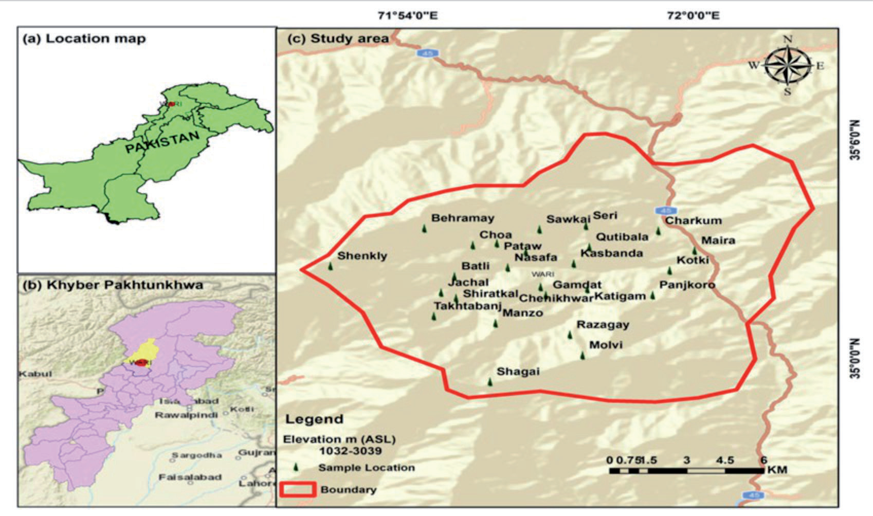
The beautiful Sultan Khail Valley is located in the western part of the Tehsil Wari, Dir Upper, Pakistan. The valley is bounded by the Panjkora River and Nehag Dara to the east, Dir Lower (Maidan) to the west, Jelar Valley to the south, and Kair Dara to the north (Fig. 1). It is located in the subtropical, arid, and temperate zone of Pakistan [18] between “34°59.339’’and 35°59.870’’ north latitude and 71°00.176’’ and 72°00.036’’ east longitude. The altitude of the area varies between 1015 and 3230 meters. The valley is largely dominated by hills and mountains that are part of the Hindu Kush range of Pakistan. The total area of the Sultan Khail Valley, Dir Upper, Pakistan, is 84.2 km2, of which almost 70% of the area is covered by forests. The climate of the study area is influenced by various topographical and ecological factors. There are four distinct seasons in the year in the area. The winter season is very cold and severe, starting in mid-November with an abrupt drop in temperature. Summer temperatures in the valley are generally moderate, with June and July being the hottest months of the year. January and February are the coldest months of the year in the region, with the average minimum temperature in January falling below zero degrees Celsius. The highest rainfall occurs in February, March, and August. In the upper parts of the valley, it usually starts snowing in December, and temperatures gradually drop [25].
Data Collection
In the years 2017 to 2019, regular trips were carried out to collect data. The valley was divided into various ecological zones based on altitude, aspect, and physiognomy. Two hundred “releves” (10 m × 10 m for trees and shrubs and 1 m x 1 m for herbs) were created for data collection. The geographical coordinates (WGS 84) and the altitudes of all the open areas were measured with a GPS device. The slope was calculated using a magnetic compass, while the angle of inclination was determined using a clinometer. Canopy cover or vascular plant species abundance was determined using the [26] canopy frequency scale. The soil was randomly sampled at three locations in each plot to a depth of 15 cm and mixed to form a composite sample, placed in a polyethylene bag, and labeled. The collected plant specimens were identified from the flora of Pakistan [27, 28].
Soil Analysis
The soil was analyzed at the Agricultural Research Station, Mingora, Swat. The soil texture was determined using the hydrometer method [28]. Soil pH was determined in a 1:5 soil water suspension [29], while soil lime content was determined using an acid neutralization method according to [30], soil organic matter was determined according to [31], phosphorus was determined according to [32], potassium and nitrogen from basic soil were extracted using AB-DTPA, and total potassium was determined according to [33]. Nitrogen was extracted according to [34].
Data Analysis
The structural data of 218 species and 200 reliefs corresponding to various topographic and edaphic variables were entered into a Microsoft Excel spreadsheet and exported as standard CSV files in JUICE V. 7.1.30 [13] for multivariate analysis. The modified two-way analysis of indicator types (TWINSPAN) was selected for clustering in the JUICE package. Whittaker’s beta-diversity and five pseudospecies thresholds (0, 2, 5, 10, and 20) were set as TWINSPAN parameters for clustering. To emphasize diagnostic, constant, and dominant species [35], a threshold of 40% was set for the fidelity, abundance, and cover of species in each association. Associations were named based on the highest fidelity abundance, and cover values of three species. ArcGIS version 9 [36] was used for map generation.
Results
Classification of Vegetation
In the present study, the vegetation data of 218 plant species and two hundred vineyards was analyzed using the Juice software (version 7.1). The modified TWINSPAN analysis resulted in the formation of 5 vegetation associations (Fig. 2) with 6.729% dissimilarities and five pseudo-species intersection levels (0, 2, 5, 10, and 20). A summary of the species fidelity values of species and their percentage abundance and important associations is summarized below.
Abies-Picea-Sibbaldia Association (APS)
This association is found at higher altitudes (2468- 3230 m) in Shekly Hill, Behramay, Shagay, Takhtabanj, and Sawkai on the east, east-south, and east-north slopes, with an average slope angle of 35.55±10.54 degrees. This association included 22 relevant and 75 species. The soil of this association was loamy in texture and slightly alkaline, with a pH of 7.1±0.43. The organic matter content was 0.53±0.31%. The phosphorus (7.0±1.05) and potassium (61.23±10.8) content of the soil of this community was low, while the lime and nitrogen content was high (Table 1). The cover of herbaceous flora was highest in this association with a mean value of 82.27±13.57, followed by the cover of trees (56.55±18.47) and shrubs (29.95±31.03) (Table 1). The diagnostic species of this association were A. pindrow with a fidelity value of 82.5, P. smithiana (70.8), and S. cuneata (63.2). Other diagnostic species of this association were E. multiradiatus with a fidelity value of 57.3, A. margaritacea (55), B. amplexicaulis (53), P. nemorosa (52.1), S. cordata (51.1), T. linearis (49.2), A. obtusiloba (48), R. webbiana and P. denticulata (43.6 each), D. indica (42.8), A. flavum (40.3), P. floribunda (41.2), N. discolor (40.5), and C. reflexum (48.7). Among the constant species, the frequency of D. indica was 82, A. pindrow (73), P. smithiana (64), V. canescens (59), E. multiradiatus (57), P. wallichiana, A. flavum (55), G. aparine (50), I. heterantha, S. cuneata, C. reflexum (45 each), A. margaritacea and B. amplexicaulis were represented with the same frequency value (41 each). A. pindrow and I. heterantha were recognized as dominant species in this association as they were represented with the highest values.
Fig. 2.
Cluster dendrogram of five association of Sultan Khail valley, Dir Upper, Hindukush range of Pakistan.
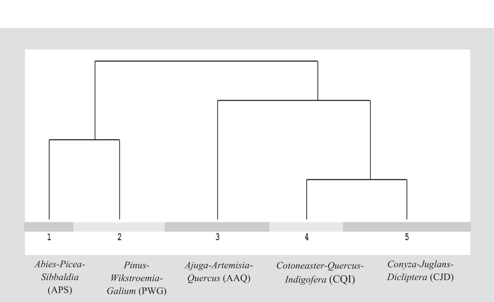
Table 1.
Environmental variables and average cover of different layers of vegetation in the five associations of the Sultan Khail Valley, Hindukush range of Pakistan.
Pinus-Wikstroemia-Galium Association (PWG)
This association is found in Jachal, Gamdat, Batli, Behramay, Malovi, Manzo Nasafa, Razagay, Shagay, and Shiratkal at an altitude of 1585-2631 m, (2070.41±221.97) mean altitude, and 35.20±8.51 degree slope angle. The mean value of aspect shows that this association is mainly found in the valleys with east-north, east-south, northwest, and west aspects. This association included 41 relevant and 114 species. The soil of this association was loamy sand, with an acidic (pH 6.8), the lime content was higher than that of the soil of the CQI association, but lower than that of the other sites. The concentrations of organic matter, nitrogen, phosphorus, and potassium were low (Table 1). The average percentage of tree species was found to be 56.10±18.36%, shrubs 54.39±22.39, and herbs 68.54±18.91%.
Among the diagnostic species of this association, P. wallichiana was represented with a fidelity value 50.2, G. aparine, (52.1) W. canescens, (42.6), P. jacquemontiana, (41.9), and T. anathera with 41.1. Among the constant species, the frequency of G. aparine (90) was P. wallichiana (78), V. canescens, T. anathera (73 each), D. indica, B. lyceum (68 each), I. heterantha (63), I. rugosus (59), Q. dilatata (46), W. canescens, and A. flavum (41 each). P. wallichiana, Q. baloot, Q. dilatata, and P. jacquemontiana are the predominant species in this association.
Ajuga-Artemisia-Quercus Association (AAQ)
This association is found in the foothills of the lower half of the valley in Nagrail, Chenikhwar, Kasbanda, Qutibala, Seri, Panjkoro, Katigam, Maira, Kotki, Charkum (upper part), and in the lower parts of Gamdat, Sawkai, Malovi, and Razagay at low altitude (1072-1810 m, mean 1427.96±211.31 m), and with low degree slope angle (27.64±9.80). The mean value of aspect shows that the sites were mostly oriented east-north and east-south (Table 1). The texture of the soil was loamy-sandy, silty-loamy to clayey, and alkaline, with an average pH of 7.0±0.76. The organic matter and potassium content were higher than the soils in the other associations. The lime concentration was low compared to the soils of the APS association. Nitrogen and phosphorus were found to be 0.12±0.2 and 7.7±1.92, respectively (Table 1).
This association comprised 85 species found in 47 relevés. The proportion of herbs (62.70±15.91%) and shrubs (32.40±14.61%) was low compared to the other associations. The mean cover of tree species (59.68±14.79%) was low compared to the CJD association, while it was higher than other associations.
The diagnostic species of this association were T. stocksianum, with a fidelity value (66), A. scoparia (54.3), O. ferruginea (42.7), Q. baloot (41.4), A. bracteosa (54.7), M. biflora (46.6), and P. paronchioides (44.1). Among the constant species of this association, the abundance of Q. baloot (91) was observed, followed by A. bracteosa (77), M. biflora (74), O. ferruginea (68), A. scoparia (66), T. stocksianum (55), O. corniculata (53), M. africana (49), P. paronchioides (43), C. nummularia (40), O. vulgare (40), and P. aviculare (40). This association was represented by three dominant species (Q. baloot, M. africana, and P. roxberghii).
Cotoneaster-Quercus-Indigofera Association (CQI)
This association was found at an altitude of 1258- 2251 meters and a mean altitude of 1720.61±255.39 meters in Behramay, Sawkai, Pataw, Choa, Batli, Shiratkal, Takhtabanj, Malovi, Razagay, Nasafa, Nagrail, Panjkoro, and at the lower end of Chenikhwar Hill. This association was found on the north, northwest, east-south, and east-north slopes with an average slope angle of 29.24±8.73 degrees (Table 1). The soil texture was predominantly loamy-sandy and silty-loamy to clayey, with a maximum percentage of sand particles compared to the soils of the other communities. The soil was acidic in nature with a low lime concentration; the organic matter content was 0.58±0.33%, the nitrogen content (0.14±0.25), and the phosphorus content (7.5±1.95). The potassium content was high compared to the soils of the APS and PWG associations (Table 1). A total of 105 species were found in the 33 relevant areas of this association. The average cover of the tree layer was 56.06±20.62%, the shrub layer (54.30±19.74%), and the herb layer (67.39±17.73%) (Table 1).
C. microphyllus was the only diagnostic species of this association. Consistent species in this association were Q. baloot with a frequency of 88, C. microphyllus (79), I. heterantha (82), B. lyceum (76), and V. canescens (73). I. rugosus, O. corniculata, and T. anathera were equally represented, with a frequency value of 64 each. Similarly, the abundance of C. nummularia, M. africana, G. aparine, M. biflora was equal (45 each), while the abundance of Q. dilatata was 42. Q. baloot, and I. heterantha were observed as dominant species in this association.
Conyza-Juglans-Dicliptera Association (CJD)
This association included 57 releves and 140 species distributed in Kotki, Qutibala flore, Chenikhwar, Batli, Choa, Gamdat, Kasbanda, Katigam, Maira, Malovi, Nagrail, Nasafa Panjkoro, Pataw, Razagay, Seri, Shagay, and Shiratkal at an altitude of 1015-2031 meters and an average altitude of 1479.72±251.45 meters. The average slope angle for this association was 31.04±12.31. The orientation was variable and ranged from east-south to southwest, north to northwest, and east. The soils of this association were predominantly silty loam and loamy sand to loam, with a maximum proportion of silt particles compared to the soils of the other associations. Like the soils of communities 1 and 3, the soil of this association was alkaline. Organic matter content was 0.60±0.36%, lime content was 2.13±1.65% and nitrogen content was 0.13±0.3%, while phosphorus and potassium contents were higher than in the soils of the other communities. The average vegetation cover of trees (75.47±11.87%) and herbaceous layer (80.72±14.73%) was high compared to the other associations. The average shrub layer cover of this association was high compared to the APS and AAQ associations, while the shrub layer cover of the PWG and CQI associations was low (Table 1).
The diagnostic species of this association were D. bupleuroides with a fidelity value of 65.7, C. sativa (62.9), M. azedarach (58.6), F. palmate (55.9), C. canadensis (54.7), J. regia (54.5), D. lotus (52.4), A. viridis (49.8), A. cordifolia (45.7), A. altissima (47.5), T. minuta (42.9), and R. fruticosus (41.2). Among the constant species of this association, O. corniculata (84) was represented with the highest frequency, followed by C. canadensis (70), J. regia (68), C. nummularia (61), and B. lyceum (60). I. rugosus, F. palmate, and Q. baloot were represented with the same frequency (58 each). These were followed by D. lotus (54), A. altissima (53), A. cordifolia, C. sativa, and O. ferruginea (51 each), M. azedarach (42), D. bupleuroides (58), and A. viridis (40). No dominant species was found in this association.
Ordination (Vegetation Environmental Relationship): Detrended Correspondence Analysis (DCA)
The results of the ordination (DCA) of the environmental gradients in relation to the vegetation association are shown in Table 2. The DCA ordination plot shows the effects of different environmental gradients on the distribution of species in different associations. The points in the ordination diagram represent the species, while the length of the gradients indicates the importance of the variables responsible for the distribution of the species. The distance between the communities represents similarities and differences. The association Abies-Picea-Sibbaldia and the association Pinus-Wikstroemia-Galium are very close to each other and show maximum similarities. Fig. 3 shows that the Conyza-Juglans-Dicliptera association represented in the first quadrant (upper left) along axis 2 is composed under the influence of high pH (7.2±0.46), high phosphorus (8.1±2.24), medium nitrogen (0.13±0.3), and variable aspects mainly from east-south to southwest, from north to northwest, and from east to east. In the second quadrant (bottom left) of the DCA order map (axis 1), the species of the Ajuga-Artemisia-Quercus association are gathered under the influence of a high organic matter content (0.62±0.41%) and a low sand particle content (44.88±14.7%) in the soil. The plant species of the Pinus-Wikstroemia-Galium association represented in the third quadrant (bottom right) are gathered under the influence of a high altitude (2070.41±221.97 m) and a low concentration of lime (2.06±1.38%), while in the fourth quadrant, a low concentration of silt (41.87±8.08%), a high concentration of clay particles (17.21±5.73), a large slope angle (35.55±10.54), and a high altitude (2716.91±185.23 m) are the main gradients controlling the distribution of plant species in the Abies-Picea-Sibbaldia association (Figs. 3, 4, and 5).
Correlation of DCA Ordination Axes with Environmental Variables
The results of the Pearson product movement correlation of the DCA ordination axis with the environmental gradient are shown in Table 3. A significant positive correlation was found between altitude and Releves value on axes 1 and 3. Orientation was negatively correlated with axes 1, 2, and 3, but highly significantly correlated with axis 1. The slope angle was significantly correlated with axes 1, 2, and 3. Abies-Picea-Sibbaldia associations and Pinus-Wikstroemia-Galium associations were found at high altitudes and with a strong slope angle in the valley. DCA axes 1 and 2 are significantly correlated with clay (%), while a significant negative correlation of potassium with DCA axes 1 and 3 was observed. DCA ordination axis 2 is significantly correlated with soil pH (Table 3).
Discussion
The spatial distribution of plant associations in the area is apparently determined by a complex of environmental factors such as climate, topography, soil, and anthropogenic factors. These factors change to varying degrees due to their interactions, resulting in microgradients [37]. Different communities are found at different altitudes, aspects, and slopes. Sultan Khail is located in the subtropical, temperate, and, to a limited extent, in the subalpine zones of Pakistan [38]. Due to marked differences in local climate, topography, edaphic, and physiographic conditions, five different types of vegetation associations are found in Sultan Khail Valley (Fig. 2 and Table 1). The APS association is found at higher altitudes (2468-3230 m) of the valley on the east, east-south, and east-north slopes with an average slope angle of 35.55±10.54 degrees. The soil of this association had a loamy texture, was slightly alkaline, and had low concentrations of organic matter, phosphorus, and potassium, while the lime and nitrogen content was high compared to the soils of the other vegetation groups (Table 1). The influence of the physico-chemical properties of the soil on the distribution of plant species is also described by [5, 24, 39]. An almost similar community was also reported by [40] from Azad Kashmir and from the alpine and subalpine zones of Miandam, northern Pakistan [41]. Also [42], A. pindrow was reported as being the dominant species in seven communities in Sudan Galli, Bagh, at 2200 m to 2500 m altitude. A. pindrow is also described by [24] in association with P. wallichiana at almost the same altitude in Skyland. Also, [5] reported A. pindrow as a codominant species in a community with C. deodara in Chitral and stated that A. pindrow and P. smithiana are the indicator species for the ecotonal zone between dry and moist temperate areas. A. pindrow and P. smithiana were also observed in association with C. deodara [6, 43] from different climatic zones of the Himalayan and Hindukush regions of the country. Most of the diagnostic, constant, and dominant species found in this association were also reported from Skyland Dir Upper [24], Kabal (Swat) [4], and Azad Jammu and Kashmir [40]. The reason for this could be due to almost the same altitudinal differences. We found the Pinus-Wikstroemia-Galium (PWG) association at the second highest altitude in Sultan Khail Valley, at almost the same slope angle as the APS association. This association is mainly found in the valley at east-north, east-south, northwest, and west orientations. This association comprised 41 releves’ and 114 species. The soil of this association was loamy sand with acidic (pH, 6.8), the lime content was higher than that of the soils of the CQI association, while it was low compared to the soils of the other associations. The content of organic matter, nitrogen, phosphorus, and potassium was low compared to the soils of the other associations. P. wallichiana is the dominant species in three communities, with B. lyceum, Viburnum, and A. pindrow in Skyland [24]. P. wallichiana was found to be the dominant species in Jelar Valley, while W. canescens was also found to be the dominant species in a community with B. lyceum [44]. The present finding is also in agreement with [45], who reported the community structure in the temperate forests of Swat and found P. wallichiana to be a dominant species in two communities with Indigofera, Galium, Viburnum, and Leucas. A similar study was conducted by [46] in Naran Valley. Also, [47] conducted a similar study and found P. wallichiana to be dominant in all communities at an altitude of 1200 m to 3600 m in Thandiani in the western Himalayas. [40] reported on pine forests in Azad Jammu and Kashmir and found P. wallichiana to be dominant in two communities, while [41] reported P. wallichiana as the dominant species in three communities in association with Q. floribunda, S. tomentosa, and I. heterantha from Miandam, northern Pakistan.
Fig. 3.
DCA ordination plot represent the relationship of releves and species with environmental gradients. The dots represent the distribution of species. Numbers: 1-5 represent associations.
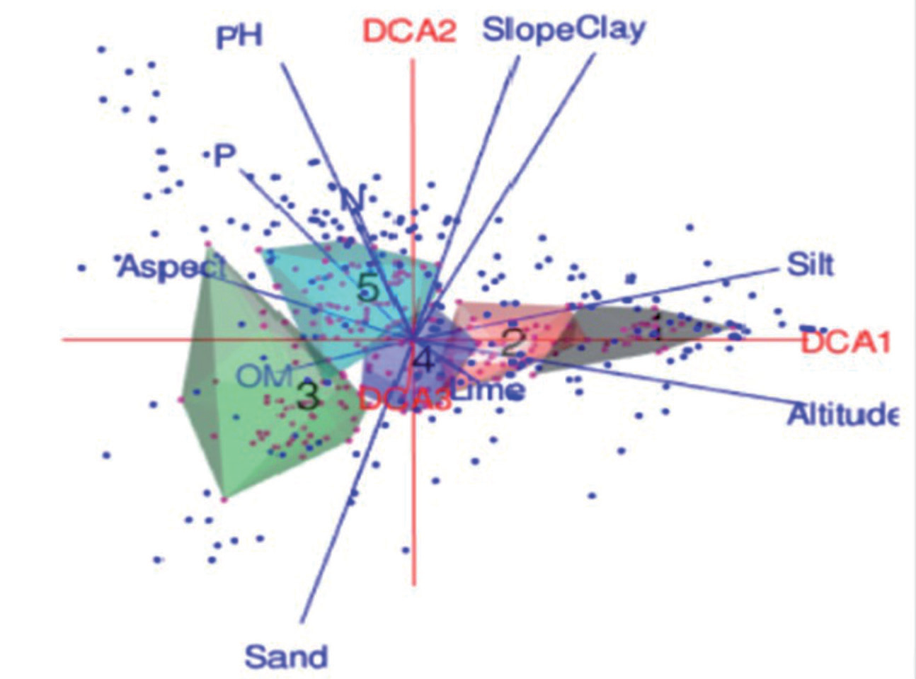
Fig. 4.
DCA ordination plot represent the distribution of species along the DCA ordination axis in different association. Numbers: 1-5 represents associations.
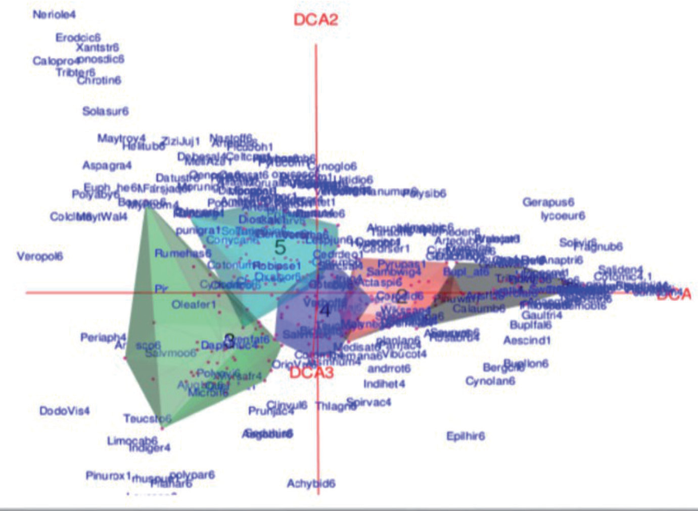
Fig. 5.
DCA ordination plot showing the effect of different environmental gradients on the distribution of species in different associations. Dots represent distribution of the species in associations (1-5).
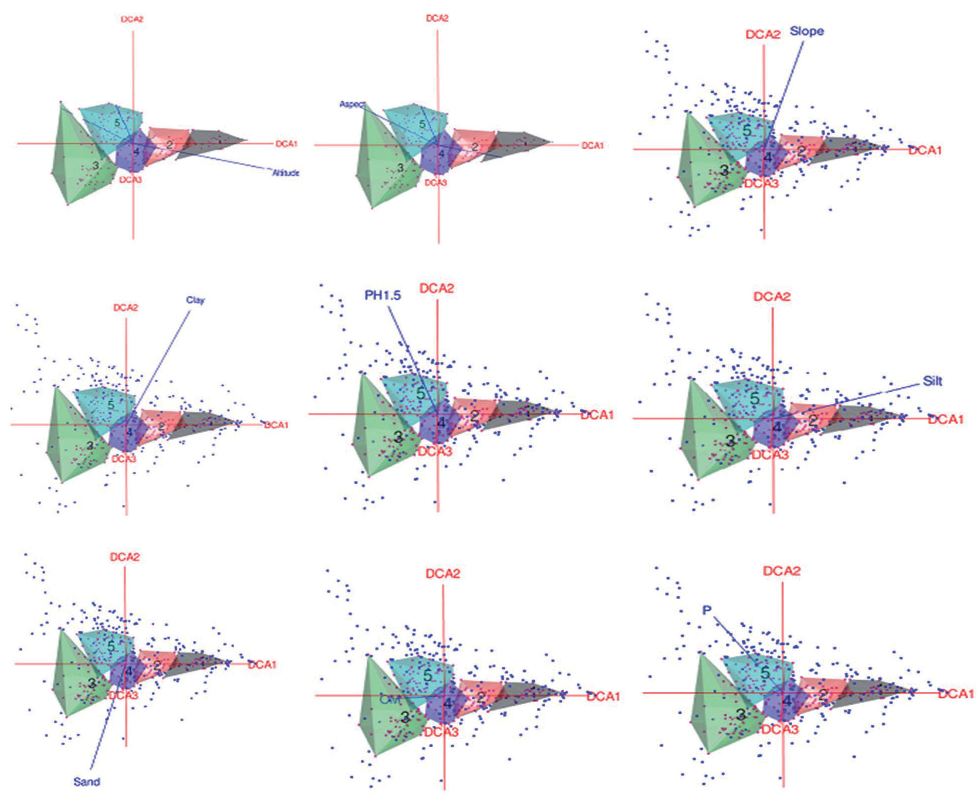
Table 3.
Pearson’s correlations between explanatory variables and DCA relieve scores along the first three axes of DCA ordination axes.
The AAQ association is found in the foothills of the lower half of the valley at low altitudes and with a low slope gradient in east-north and east-south orientations. This association included 85 species found in 47 releases. The soil was loamy-sandy, silty-loamy to clayey, and alkaline, and the organic matter and potassium content were high compared to the soils in the other groups. The lime concentration was low compared to the soils of the APS association. Nitrogen and phosphorus concentrations were 0.12±0.2 and 7.7±1.92, respectively. The present results are in agreement with [5, 17, 23]. Q. baloot is a stress-tolerant species, but it is under high pressure in this area due to its valuable wood for fuel purposes. The other characteristic species found in this association were also reported by [6, 41, 44] and [48], indicating almost similar climatic conditions in the areas or a wide range of ecological amplitude for these dominant species.
The Cotoneaster-Quercus-Indigofera association (CQI) is found at an elevation of 1258-2251 meters and a mean elevation of 1720.61±255.39 meters in the north, northwest, east-south, and east-north orientations in the valley, with an average slope angle of 29.24±8.73 degrees. A total of 105 species were found in this association with 33 relevesˊ. The soil was mostly loamy-sandy, silty-loamy to clayey, and acidic, with a high proportion of sand particles and a low concentration of lime compared to the soils of the other communities. The organic matter content was 0.58±0.33%, the nitrogen content (0.14±0.25) and the phosphorus content (7.5±1.95). The potassium content of the soil was high compared to the soils of the APS and PWG associations. C. microphyllus proved to be the only diagnostic species in this association, while the dominant species were Q. baloot and I. heterantha. C. microphyllus was also described by [49] as the dominant species in a community from Swat, while Q. baloot and I. heterantha were described as dominant in different communities from the temperate forests of Swat [45], Dir [17], and Jelar Valley [44], while [5] described Q. baloot as dominant in association with conifers in Chitral. The present finding is also in agreement with [50] and [41], who reported almost similar communities.
The CJD association is located at an elevation of 1015 to 2031 meters and at a mean elevation of 1479.72±251.45 meters, with a dip angle of 31.04±12.31 degrees in east-south to south-west, north to northwest, and east orientation in the valley. The soil of this association was silty loam and loamy sand to loam, with the maximum amount of silt particles while being alkaline in nature. Organic matter was 0.60±0.36%, lime content (2.13±1.65), and nitrogen content (0.13±0.3), while phosphorus and potassium content was higher than in the soils of the other communities. This association comprised 57 releve̕ and 140 species, including 12 diagnostic and 17 constant species, with no dominant species found in this association. The characteristic species of this association are also described by [4, 5, 21] and [44], while the absence of dominant species in this association is due to strong anthropogenic disturbances, as this association is easily accessible to the inhabitants of the valley.
Vegetation cover can reflect the conditions of the ecological environment [51]. Different factors, such as annual temperature, rainfall, altitude, topographic aspect, soil erosion, overgrazing [1], the physicochemical properties of the soil, and human activities [4, 38, 51], are responsible for the variation in vegetation cover. However, in the present study area, the differences in vegetation cover in different associations are due to unequal anthropogenic pressure [52, 53], different aspects, and the easy accessibility of forests in different parts of the valley for the collection of tree and shrub species by the inhabitants.
The ordination results showed that the groups identified by the cluster analysis were also superimposed on the DCA ordination axes under the influence of different environmental gradients. Climate, topographic, and physico-chemical properties of the soil and biotic pressure determined the floristic composition and spatial distribution of the communities. Any change in these parameters has a significant impact on the formation of different associations of vegetation in an area [54- 57]. The species of different associations came together under the influence of various parameters (Figs. 3, 4, and 5). Ordination is able to reveal at least one underlying gradient associated with vegetation community distribution [58, 59]. In the present study, a significant correlation was found between altitude, aspect, slope angle, clay particles, potassium content, soil pH, and DCA ordination axes. In [44], a significant correlation of ordination axes with altitude and organic matter was found. In [60], altitude, conductivity, phosphorus, and nitrogen were all observed to correlate significantly with DCA ordination axes. The present findings are consistent with [23, 55, 56] and [61]. The present results suggest that altitude, aspect, slope angle, clay particles, potassium, and soil pH are mainly responsible for the spatial distribution of species in different associations of vegetation in the Sultan Khail Valley, while friction factors move along.
Conclusions
We concluded that the vegetation of the Sultan Khail Valley consists of five main associations namely: Abies-Picea-Sibbaldia association (APS), Pinus-Wikstroemia-Galium association (PWG), Ajuga-Artemisia-Quercus association (AAQ), Cotoneaster-Quercus-Indigofera association (CQI), and Conyza-Juglans-Dicliptera association (CJD). The soils of the study area are loamy, loamy sand to silty loam, alkaline to acidic with varying contents of lime, organic matter, nitrogen, phosphorus, and potassium. The altitude aspect, slope angle, clay content (%), potassium, and soil pH are the main factors controlling the distribution of species in the different associations of the valley, while the other factors are in flux.

